
Comprehensive Plan
2019-2040
Conservation and Open Space
GOAL
TO CONSERVE, MANAGE AND RESTORE OR ENHANCE THE NATURAL AND HUMAN-RELATED RESOURCES OF ALACHUA COUNTY TO ENSURE LONG-TERM ENVIRONMENTAL QUALITY FOR THE FUTURE.
1.0 CONSERVATION OVERVIEW
OBJECTIVE 1.1 - CONSERVATION STRATEGIES
Embrace multiple, diverse strategies for the conservation of natural systems in Alachua County.
Policy 1.1.1 The County shall promote the long-term maintenance of natural systems through a comprehensive approach that involves education, public participation, regulations, incentives, acquisition, intergovernmental coordination, and other appropriate mechanisms.
OBJECTIVE 1.2 - CONSERVATION AS PRIORITY
Establish environmental conservation as a priority in all decision-making for Alachua County.
Policy 1.2.1 Any decision may directly or indirectly affect the conservation, management, preservation, enhancement, and use of the natural resources of Alachua County. It is the intent of this Element that County officials, staff, and citizens constantly monitor all decisions for the effects they may have on appropriate conservation and use of resources, and that such decisions be made with consideration given to the principles and policies of the Comprehensive Plan and this Element.
Policy 1.2.2 The County shall establish as a priority all principles and policies in this Element when making decisions concerning new or expanded public facilities.
2.0 ENVIRONMENTAL INFORMATION MANAGEMENT
OBJECTIVE 2.1 - INFORMATION SYSTEM
Establish an information system for the natural resources and human-related resources associated with the natural environment, and be proactive in providing public access to this information. Use the information system to measure environmental quality necessary to protect and maintain natural resources that provide a safe and healthy environment for all living things in Alachua County.
Policy 2.1.1 The County shall update and maintain the Conservation Element Map Series and related information system containing data relevant to protect the environmental quality of Alachua County's natural resources. The information shall include, at a minimum, an inventory and maps of:
(a) Surface waters, wetlands and floodplains;
(b) Groundwater resources, including high aquifer recharge areas and wellfield protection areas, and groundwater quality;
(c) Strategic ecosystems;
(d) Listed species and their habitat;
(e) Public parks, preserves and forests, including those held in fee and less than fee simple ownership, such as conservation easements and leaseholds;
(f) Significant geologic features;
(g) Scenic corridors;
(h) Hazard areas including fire and flood prone areas, and existing and potential hazardous materials storage, treatment, and disposal sites; and
(i) Alachua County soil survey and maps.
(j) Open space and greenways.
Policy 2.1.2 Alachua County shall establish a monitoring program using performance indicators to determine the health of natural resources. The monitoring program shall be developed as part of a special work program that includes the following components:
(a) The County shall develop indicators that highlight changes in natural resources.
(1) Indicators may include but are not limited to:
a. Indicators of natural resource losses:
1. Loss of various types of habitat, including wetlands and uplands.
2. Increase in density or intensity of zoning, land use and development in conservation areas.
3. Increase in impervious surfaces in the unincorporated portions of the County.
4. Acres of land converted from agriculture and silviculture.
5. Habitat fragmentation.
6. Acres of forest converted to plantations.
b. Indicators of natural resource gains:
1. Number of acres of preservation land owned or protected by the public or private sector.
2. Number of acres of land that is restored to more natural functioning or quality.
3. Number and acreage of farms using sustainable practices for irrigation, fertilizing, and disposal of animal wastes.
4. Number of housing developments utilizing native plant materials.
5. Acres of forest under certified sustainable management.
c. Indicators whose change may show either natural resources gains or losses:
1. Tree canopy.
2. Air quality.
3. Surface water and ground water quality.
4. Results of voluntary community-based species counts such as Audubon bird counts.
5. Number of listed and/or indicator (key) species.
(b) Indicators shall be tracked and measured incrementally using a geographic information system as part of the land use planning and development review processes.
(c) The County shall implement a performance-based development review process based on selected indicators in conjunction with items in the natural resources checklist referenced in Policy 3.4.1.
(d) The County annually shall compile and review data on selected indicators to determine resource losses and gains and the impacts of development on natural resources in Alachua County.
(e) These data shall be gathered from best available existing sources, including development review data, aerial photography, and mapping resources of other governmental agencies, academic institutions, and non-profit organizations.
(f) The review shall include an evaluation of the effectiveness of current policies and land development regulations, and identification of areas that need improvement to ensure the meaningful protection of natural resources.
(g) The County shall incorporate the results of the review into an annual report that presents the state of the County’s natural resources. The report shall be publicized and made readily accessible to all members of the community.
OBJECTIVE 2.2 - EDUCATION AND OUTREACH
Increase public understanding of natural resources issues and provide access to the most current and reliable information so that the public may make informed decisions regarding their health, welfare, and safety.
Policy 2.2.1 The County shall encourage environmental stewardship among all citizens of Alachua County by advancing conservation principles in the everyday operations of Alachua County.
Policy 2.2.2 The County shall implement proactive, innovative, and creative educational programs concerning natural resource issues including, but not limited to:
Air quality;
Surface water and wetlands quality and function;
Groundwater quality and vulnerability;
Water conservation;
Wildlife and aquatic species and habitat;
Native vegetative communities;
Invasive species control;
Natural areas protection;
Agricultural preservation;
Sustainable agriculture and forestry;
Soil conservation;
Energy conservation;
Flood and fire hazard mitigation;
Hazardous waste; and
Waste management.
Policy 2.2.3 The County shall actively pursue interactive public involvement and functional partnerships with the School Board of Alachua County, private schools, the University of Florida and Santa Fe College, the Alachua County Extension Office, and environmental and agricultural organizations, for the purposes of developing and disseminating educational materials and programs.
Policy 2.2.4 The County shall develop and disseminate information bulletins regarding development review regulations and criteria which can be used in the field by field technicians to promote environmentally responsible land use and development practices.
Policy 2.2.5 Educational materials shall be made available to developers, homeowners, and other interested citizens concerning proper maintenance, management, restoration, and development in natural areas (for example, habitat creation, endangered species, management of development ponds, wetlands vegetation, xeriscape, water quality, and water conservation).
Policy 2.2.6 The County shall recognize individuals, groups, developments and projects that exemplify concepts of environmental stewardship embodied in the Comprehensive Plan.
Policy 2.2.7 The County shall actively pursue funding sources for environmental programs based on volunteer participation, such as the River keepers, Lake Watch, World Games, Forest Stewardship Council certification, and Environmental Justice/Environmental Ambassadors programs.
Policy 2.2.8 Where consistent with natural resources protection, the County shall provide interactive opportunities for education and public viewing and enjoyment of wildlife at County-owned lands.
OBJECTIVE 2.3 - RESOURCE AREAS PLANNING
Manage natural resources at a scale appropriate to their protection, and facilitate consensus-building in the public participation process.
Policy 2.3.1 The County shall implement a geographic area-based approach to environmental planning programs.
(a) Area boundaries shall be determined based on the location of natural resources, for example, watersheds.
(b) The County shall seek residents, property owners, and business owners in the area that represent a diversity of environmental, economic, and social interests to form a task force in each area.
(c) Each task force shall work with the County to create plans for the efficient utilization and conservation of human-related and natural resources in the area.
Policy 2.3.2 A Community and Neighborhood Planning program, per Future Land Use Element Section 7 (Implementation), shall address conservation issues including provisions for regional habitat corridors, watersheds and greenways.
3.0 ENVIRONMENTAL LAND USE CATEGORIES
OBJECTIVE 3.1 - CONSERVATION LAND USE CATEGORIES
A conservation land use category shall be established to recognize and protect natural resources within privately owned lands in Alachua County utilizing appropriate regulatory, acquisition, and incentive mechanisms.
Policy 3.1.1 Conservation areas shall consist of natural resources that, because of their ecological value, uniqueness and particular sensitivity to development activities, require stringent protective measures to sustain their ecological integrity. These areas shall include:
(a) Wetlands;
(b) Surface waters;
(c) 100-year floodplains;
(d) Listed species habitat;
(e) Significant geologic features;
(f) Strategic ecosystems; and
(g) Champion trees and Landmark Live Oaks.
Policy 3.1.2 In conservation areas, the following uses, if otherwise consistent with the Comprehensive Plan, generally shall be permitted to the extent that they do not significantly alter the natural functions of the conservation area:
(a) Public and private conservation, recreation and open space uses.
(b) Public and private wildlife preserves, game management and refuge areas.
(c) Water conservation and retention/detention areas that are determined to be appropriate for stormwater management.
(d) Agricultural uses, employing latest applicable best management practices.
Policy 3.1.3 Conservation areas shall be developed only in a manner consistent with protection of the ecological integrity of natural resources, and in accordance with standards which are outlined subsequently in this Element.
Policy 3.1.4 All conservation areas should be avoided as potential locations for personal wireless service facilities.
Policy 3.1.5 Certain resources such as mineral resources and high aquifer recharge areas, because of their location, nature, or extent cannot be protected to the extent of conservation areas, but have been identified for protection in this Element. Policies applicable to these resources shall be those specific policies in Section 4 which apply to development activities within or affecting such areas and policies which apply generally to natural resources.
OBJECTIVE 3.2 - PRESERVATION LAND USE CATEGORY
A preservation land use category shall be established to recognize and protect natural resources within publicly owned lands in Alachua County.
Policy 3.2.1 Preservation areas shall consist of publicly owned lands, including lands owned and managed by non-profit conservation organizations, which are intended for use as natural reserves or managed conservation lands for the preservation of natural resources in perpetuity.
Policy 3.2.2 Preservation areas shall include but are not limited to:
(a) Austin Carey Memorial Forest;
(b) Goethe State Forest (Watermelon Pond Unit)
(c) Gum Root Swamp Conservation Area;
(d) Lake Alto Swamp;
(e) Lochloosa Wildlife Conservation Area;
(f) OLeno State Park;
(g) Orange Lake (Bird Island);
(h) Paynes Prairie Preserve State Park;
(i) Poe Springs;
(j) Prairie Creek Conservation Area;
(k) River Rise Preserve State Park;
(l) San Felasco Hammock Preserve State Park;
(m) Santa Fe Swamp Conservation Area;
(n) Warren Cave; and
(o) Property acquired in fee or less than fee simple for preservation by federal, state, and local agencies, Water Management Districts, local municipalities, or Alachua County for use as natural reserves or managed conservation lands for the preservation of natural resources in perpetuity. The identification of less-than-fee properties as preservation areas will be based on the management goals and objectives for the property. This includes properties acquired or managed under programs such as Alachua County Forever, Florida Communities Trust, Save-Our-Rivers, and Conservation and Recreation Lands.
Policy 3.2.3 A management plan shall be developed for each preservation area by the responsible public agency, in accordance with the following:
(a) The management plan shall include but is not limited to:
(1) Documents and maps that identify the location of areas and natural resources to be preserved, including any protective buffers.
(2) An assessment of the existing quality and characteristics of the natural resources to be preserved and/or restored.
(3) A description of the goals and objectives for each site.
(4) A description of all proposed uses, including existing and any proposed physical and access improvements.
(5) A description of activities that will be performed to protect, restore, or enhance the natural resources to be preserved.
(6) A set of schedules and assignments of responsibility for specific implementation activities to be performed as part of the management plan.
(b) The management plan shall take into account the ownership interests of public and private entities and provide for protection of private ownership interests.
(c) If a preservation area is subject to a conservation easement, the agreement for the conservation easement may serve as the management plan in the absence of a management plan.
(d) The land shall be subject to the conservation policies of the Comprehensive Plan that are applicable to the resources within those areas.
OBJECTIVE 3.3 - FUTURE LAND USE MAP
Identify conservation and preservation areas on the Future Land Use Map.
Policy 3.3.1 The adopted Future Land Use Map shall identify wetlands, surface waters, wellfield protection areas, 100-year floodplains, soils, strategic ecosystems and preservation areas.
Policy 3.3.2 The Conservation Element Map Series data and analysis shall identify the resources listed in policy 3.3.1, as well as other conservation areas, in the form of individual, resource-specific maps consistent with policy 2.1.1.
Policy 3.3.3 The adopted Future Land Use Map and the Conservation and Open Space Element Map Series data and analysis are general in nature.
(a) This mapping shall be based upon the best available digital data sources, including digital resources from the National Wetlands Inventory, Florida Geographical Data Library, Water Management Districts, Federal Emergency Management Agency (FEMA), and United States Department of Agriculture Natural Resources Conservation Service (USDA-NRCS).
(b) This mapping shall be used for multiple planning purposes, for example, as a first review in the land use, zoning, and development approval processes, as a tool in the identification and evaluation of potential land acquisition projects, and as a guide in identifying potential special area planning boundaries.
Policy 3.3.4 Site Specific Delineation: The parcel-specific boundaries of preservation and conservation areas shall be verified by ground surveys conducted in the course of special studies or development review. County-initiated mapping efforts shall be performed at the County’s expense, except when an applicant seeks land use change, zoning change, or development approval prior to the completion of the County’s mapping efforts, consistent with policies 3.4.2 and 4.10.3. Conservation policies shall be applied based on the resulting site specific delineation.
OBJECTIVE 3.4 - DEVELOPMENT REVIEW PROCESS
Protect natural resources during the land use planning and development review process from activities that would significantly damage the ecological integrity of these areas. The applicability of the policies and standards in this section shall be determined for all development at each stage of the land use planning, zoning, and development review and permitting process.
Policy 3.4.1 All applications for land use change, zoning change and development approval shall be required to submit an inventory of natural resource information.
(a) The inventory shall include site specific identification, mapping, and analysis of each natural resource or natural resource characteristic present on or adjacent to the site.
(b) The inventory shall be prepared by person(s) qualified in the appropriate fields of study, and conducted according to professionally accepted standards.
(c) The County shall provide a natural resources checklist to each applicant identifying natural resources that must be analyzed.
(d) The analysis shall consist of a resources management plan that includes the following:
(1) an assessment of the existing quality and characteristics of each natural resource,
(2) an evaluation of the impact of the proposed land use change, zoning change, or development on the resource, with consideration of the indicators in Policy 2.1.2,
(3) a discussion of the proposed measures to protect or mitigate the impacts on the resource, and
(4) a maintenance and monitoring plan.
(e) In the land use and zoning context, the County shall use this information to determine whether the requested change is consistent with protection of natural resources. In the development review context, the County shall use this information to determine appropriate site designs and strategies that maintain and protect the character and amenities of the natural environment on the site during construction and after development.
Policy 3.4.2 Where site specific analysis or verification is required to determine the presence of natural resources protected under this Element the cost of such analysis or verification shall be borne by the applicant.
Policy 3.4.3 The County shall require landowners or developers to notify and copy the Alachua County Environmental Protection Department on permit applications, approvals, compliance and enforcement issues, and other significant contact with Water Management Districts and state and federal environmental permitting agencies.
Policy 3.4.4 For certain developments located within greenline areas designated by the Florida Department of Environmental Protection around State parks and preserves, the County shall notify and request comments from the State Division of Recreation and Parks(DRP) concerning potential impacts that such developments could have on the State parks or preserves. The notification process shall apply to those developments meeting specified threshold requirements to be developed by the County and the State Division of Recreation and Parks. Information provided by DRP shall be considered with other comments during rezonings and the development review processes prior to making decisions regarding proposed developments.
OBJECTIVE 3.5 - DEVELOPMENT REGULATIONS
Adoption of new or revisions to existing land development regulations based on policies in this Element shall begin immediately following the adoption of this Element by the Alachua County Board of County Commissioners and shall be completed in accordance with a rigorous adoption schedule.
Policy 3.5.1 The County shall collaborate with affected local, state, and federal regulatory agencies and the Water Management Districts to adopt and enforce specific land development regulations (LDRs) that implement the goals, objectives, and policies of this Element and provide the fullest protection for natural resource areas and characteristics.
Policy 3.5.2 LDRs shall provide performance standards for development in and adjacent to conservation and preservation areas to protect and enhance the natural, physical, biological, ecological, aesthetic, and recreational functions of these areas. Performance standards for the rural area shall include innovative approaches such as flexible lot sizes, clustered subdivisions, setbacks, buffers, and density transfers as provided in the policies under Objective 6.2 of the Future Land Use Element.
Policy 3.5.3 LDRs shall provide standards for the placement of public facilities that address, at a minimum, the impacts to air, surface water and groundwater quality, wildlife, vegetation, natural systems function, noise, and waste disposal.
OBJECTIVE 3.6 - RESOURCE PROTECTION STANDARDS
Protect natural resources by requiring that all development activities be conducted in accordance with at least minimum resource protection standards.
Policy 3.6.1 All development shall conform with the environmental regulations of federal, state, and local agencies as well as the Water Management Districts.
Policy 3.6.2 The County shall coordinate with adjacent counties and WMDs to conserve, appropriately use, or protect unique natural resources located within more than one local jurisdiction.
Policy 3.6.3 Parcels that include or are adjacent to conservation or preservation areas shall not receive planning and zoning designations that are higher in density or intensity than the currently adopted designations unless adequate natural resources protection is ensured.
Policy 3.6.4 The County shall prohibit subdivision of land after January 21, 1993 that would create new lots lacking sufficient buildable area, as defined by setback requirements and other development standards, outside of conservation areas.
Policy 3.6.5 Development on land that includes conservation areas shall be sited and designed according to the following standards and consistent with policies under Objective 5.2:
(a) The preservation of conservation areas shall be required on all development sites to the greatest extent possible, consistent with standards which are outlined subsequently in this Element.
(b) Density or intensity shall be transferred from conservation areas to non-conservation portions of the property, to adjoining property under common ownership or management and within a unified development, or to other development receivership areas, at a rate consistent with that of the underlying zoning district, but not to exceed the maximum density allowed by the land use designation.
(c) When there are no non-conservation areas to which density or intensity may be transferred, the development shall be clustered in the portion of the site that will result in least environmental impact.
(d) When connection to central sewer is not required, septic wastes shall be disposed of according to the Comprehensive Plan, land development regulations, and health department standards, and without adversely affecting ecosystem health. When septic systems must be installed within surface water and wetland buffers they must be located and designed to minimize impacts to regulated resources as determined in the Land Development Regulations and Water Quality Code.
(e) Existing landscape connections to other conservation areas shall be maintained so that fragmentation is avoided.
(f) Development in rural areas shall be consistent with policies under Objective 6.2. of the Future Land Use Element.
Policy 3.6.6 Development on land that includes or is adjacent to conservation or preservation areas shall exhibit best environmental management practices with the emphasis on designing with nature, e.g. in the context of the natural features of the landscape, such as topographic and stormwater features, vegetative edges, and soil types, to avoid and minimize adverse environmental and visual impacts. The major criterion for approval shall be the continued functioning, with minimum disturbance, of the ecosystem which the development is impacting.
Policy 3.6.7 Development shall not be allowed at the maximum densities and intensities of the underlying zoning district, if those densities would be harmful to natural resources.
Policy 3.6.8 Development occurring along the edges of conservation and preservation areas shall be designed to protect and minimize the impact of development on conservation areas through the use of natural vegetative buffers.
(a) Buffer width shall be determined on a case-by-case basis depending on what is demonstrated to be scientifically necessary to protect natural ecosystems from significant adverse impact. This determination shall be made in consideration of at least the following factors:
(1) Type of development and associated potential for adverse site-specific and off-site impacts;
(2) Natural community type and associated hydrologic or management requirements;
(3) Buffer area characteristics and function;
(4) Presence of listed species of plants and animals.
(b) Absent scientific information which demonstrates that a larger or smaller buffer width is appropriate, the following buffer widths shall apply for the resources set forth in the table below.
|
Protected Resource |
Buffer Distance (feet)* |
|
Surface waters and wetlands less than or equal to 0.5 acre that do not include OFWs or listed animal species as described elsewhere in this table |
50 average, 35 minimum |
|
Surface waters and wetlands greater than 0.5 acre that do not include OFWs or listed animal species as described elsewhere in this table |
75 average, 50 minimum |
|
Areas where federally and/or state regulated vertebrate wetland/aquatic dependent animal species have been documented within 300 feet of a surface water or wetland |
100 average, 75 minimum |
|
Outstanding Florida Waters (OFWs) |
200 average, 100 minimum |
* If the buffer precludes all economically viable use of a particular property, development may be allowed within the buffer in accordance with policy 3.6.5, and where applicable, policies 4.6.6 and 4.7.4.
(c) Buffers shall be measured from the outer edge of the protected resource.
Policy 3.6.9 The County shall encourage the control or elimination where feasible, of invasive vegetation within the protected area.
Policy 3.6.10 The intensity of development on land adjacent to conservation and preservation areas shall be determined based on the unique characteristics of the conservation area. Land use shall be consistent with natural resource protection.
Policy 3.6.11 Septic tanks and drainfields shall be sited in a manner to protect conservation areas from the discharge of improperly treated effluent. The use of alternative systems shall be required under appropriate circumstances to protect environmental health.
Policy 3.6.12 All public projects, such as utilities, new travel corridors, and travel corridor modifications, shall be located and designed to avoid adverse impacts to conservation and preservation areas, except where it is demonstrated that there is no prudent and feasible alternative that avoids adverse impact. The County shall use an interdepartmental team to determine whether a particular project warrants adverse impact, based on an evaluation of the environmental, economic, and social costs and benefits of the proposal and alternatives. Inconvenience alone is insufficient justification for adverse impact.
Policy 3.6.13 In the case of a public project for which there is no prudent and feasible alternative that avoids adverse impacts to conservation and preservation areas, the project shall incorporate appropriate design features that enhance habitat connectivity, provide for the safe passage of wildlife, and provide other significant environmental benefits. Mitigation shall be required as for private developments.
Policy 3.6.14 Alachua County shall require mitigation of significant adverse impacts on conservation and preservation areas within the County. Mitigation shall include funding for the acquisition and management, preservation, replacement, or restoration of significant ecological resources.
Policy 3.6.15 The County shall identify and protect green infrastructure through the development review process by protecting conservation resources and natural areas and allow and encourage proven environmentally-friendly development techniques, like low impact development that minimize impacts to natural resources and water quality and maintain existing hydrologic conditions.
4.0 NATURAL RESOURCES
OBJECTIVE 4.1 - AIR RESOURCES
Alachua County shall take appropriate steps to maintain or improve ambient air quality to ensure the protection of public health and the environment and to exceed compliance with state and national ambient air quality standards.
Policy 4.1.1 The County shall track and maintain awareness of air quality regulatory issues and new emission sources which have the potential to impact ambient air quality in the County including the potential to increase the levels of hazardous air pollutants in the County.
Policy 4.1.2 The County shall maintain an inventory of greenhouse gas emissions (GHG) for County operations and the local community, and shall develop and implement a plan to reduce countywide GHG emissions by 80% from 2009 baseline emissions by 2050, with an intermediate goal of a 40% reduction by 2020 and a short term goal of 5% annual reduction. Findings shall be released in an annual status report for County operations, with an estimate of community emissions reported biennially (i.e., every two years). In addition to changes in total GHG emissions, reports shall include indicators of improvements in efficiency such as reductions in emissions per person, per employee or per square foot, improvements in building performance ratings, or similar measures.
Policy 4.1.3 The County shall maintain an air quality public education function that has the following components:
(a) A general air quality website to provide the public with educational information about air quality, radon and indoor air pollution issues.
(b) A radon information education program that informs the public about the soil radon potential in different areas of Alachua County.
Policy 4.1.4 All incineration, prescribed open burning, and yard trash burning shall be conducted in accordance with local, State and Federal regulations such that the health and safety of the public and the environment is protected.
(a) Open burning of land clearing debris in the urban cluster shall be prohibited. This does not preclude burning of vegetative debris accumulated as a result of cleanup from a local emergency or severe weather event, such as a hurricane or tornado. Such burning shall only be conducted with a permit from the appropriate local or state agency(s).
(b) In lieu of burning, the following practices shall be used:
(1) Vegetative debris may be ground and used as mulch or compost onsite;
(2) Vegetative debris may be delivered to an appropriately permitted facility for processing and disposal;
(3) Non-vegetative land clearing debris must be separated out of the vegetative debris and transported to an appropriately permitted facility for processing and disposal.
(c) Prescribed burning for fuel reduction or maintenance of ecosystem health shall be in accordance with a land management plan, where required, and all applicable permits.
Policy 4.1.5 Factors contributing to the maintenance or improvement of air quality shall be identified and considered during land use planning and development review. These factors include but are not limited to:
(a) Increased use of mass transit and non‑motorized modes of transportation, and the promotion of a land development pattern conducive to support of public transportation, including containment of urban development in existing urban areas or carefully planned expansions of urban areas;
(b) Increased use of green space in site planning for all types of development and along major roadways; and
(c) Increased strategic planting of trees and shrubs to shade streets and buildings, and use physical barriers if necessary to reduce particulate air pollution, and reduce energy consumption and new carbon dioxide generation caused by combustion of fossil fuels; and
(d) Control of airborne dust generated from land clearing and site preparation activities. Control may involve the use of techniques such as temporary silt fencing, immediate seeding or sodding, permanent vegetative buffering, phasing land clearing with development, or sprinkling the area with water.
(e) Promotion of industries that exceed Federal and State air quality and emission standards.
Policy 4.1.6 The County shall pursue and support programs that reduce adverse impacts on air quality due to traffic emissions by encouraging use of public transit, multiple ridership in automobiles, and safe use of bikeways.
Policy 4.1.7 Asbestos shall be surveyed for and removed by a licensed contractor prior to demolition or renovation of all buildings.
Policy 4.1.8 The County shall establish a tree planting program to improve air quality in designated areas.
Policy 4.1.9 The County shall establish an intergovernmental task force, comprised minimally of representatives from local governments and utilities, to coordinate on air quality issues such as alternative fuels and the use of hybrid fuel vehicles.
OBJECTIVE 4.2 - SOILS AND SLOPES
Reduce the rate of soil erosion and sedimentation from development activities and encourage the utilization of the soil consistent with the ability of the physical properties of the soil to support appropriate land uses.
Policy 4.2.1 Characteristics of soil suitability and capability shall be considered in determining appropriate land uses. Preliminary recommendations concerning soil suitability can be found in the Alachua County Soil Survey prepared by the United States Department of Agriculture Natural Resources Conservation Service (USDA NRCS). To insure that the soils at the development site can support the development, the County will require the developer to submit detailed information on soils which may require an independent soil analysis with detailed information on soils.
Policy 4.2.2 Land clearing. All development shall occur such that land clearing is phased with construction activity and includes measures to:
(a) Minimize soil erosion.
(b) Minimize removal of native and non-invasive trees and vegetation.
(c) Strictly limit the removal and damage of champion and designated specimen trees in accordance with policy 5.4.3.
(d) Stabilize and revegetate the site with native vegetation after clearing.
Specific criteria for achieving these standards shall be provided in the land development regulations.
Policy 4.2.3 Land shall be developed with regard for natural topographic features. The development regulations shall provide standards to minimize adverse impacts on development in areas with extreme slopes. Such standards shall include minimizing disturbance of steep slope areas in site designs by retaining existing vegetation.
Policy 4.2.4 Where steep slopes are found adjacent to watercourses, existing vegetation shall be substantially retained to minimize erosion consistent with Best Management Practices and surface water and wetland buffers. The slopes of constructed lakes from the top of the bank to the control water elevation (landward edge of littoral zone) shall be immediately stabilized using appropriate vegetation upon completion of the lake construction.
Policy 4.2.5 Development shall be designed to include retention of the natural character of seepage slopes and shallow ground water tables that have been demonstrated to be essential to the hydrologic support of associated conservation areas. Specific standards to accomplish this shall be included in the development regulations. In the interim, the Development Review Committee shall require measures that execute this policy.
Policy 4.2.6 The County shall continue to cooperate with and assist the Alachua County Soil and Water Conservation District in their efforts to implement techniques such as best management practices to reduce the rate of soil erosion. The County Agricultural Extension Office will assure that the recent applications and research results of these control techniques are made available through demonstration projects, educational seminars and information pamphlets to the public.
Policy 4.2.7 In conjunction with the Soil and Water Conservation District, Water Management Districts, the U.S. Geological Survey, and Army Corp of Engineers, Alachua County shall seek funding to perform a comprehensive soil erosion control study to identify relative erosion potentials for the soil types found in the County, identify a standard for soil erosion reduction that can be technically achieved, and require that standard be maintained at all sites where site alteration is being done.
Policy 4.2.8 All stormwater outfall and irrigation connections, including those associated with agricultural uses shall be designed to prevent erosion and sedimentation.
OBJECTIVE 4.3 - MINERAL RESOURCES
Regulate extraction activities so that they do not adversely affect the quality of air, groundwater, surface water, land, and wildlife.
Policy 4.3.1 The County shall develop a comprehensive approach to mineral resources. Existing land development regulations that address mineral resources shall be reviewed, consolidated, and revised to provide for comprehensive natural resource protection. Revisions shall include the following:
(a) Identification of a mining and excavation district, with associated policy directives.
(b) Restriction of mining and excavation in conservation and preservation areas.
(c) Provisions for avoidance, minimization, and mitigation of adverse impacts, including but not limited to impacts related to noise, lighting, traffic, habitat, listed species, air, surface water and ground water quality and quantity.
(d) Standards for reclamation and reuse that provide for restoration of the functions of natural systems.
Policy 4.3.2 The County shall review its regulatory approach to filling activities, including landfilling, and the storage and handling of construction and demolition debris. The County shall revise its approach to ensure natural resources protection and consistency with state law.
Policy 4.3.3 The development regulations shall address mining, land excavation, and filling activities, and shall include provisions for reclamation and reuse, and assure successful completion of approved reclamation and reuse plans. Mining, land excavation, and filling activities shall be consistent, at a minimum, with the Alachua County Excavation and Fill Ordinance and the Alachua County Surface Mining and Land Reclamation Ordinance which provide for permit requirements and standards for site location, site design, environmental protection and reclamation.
Policy 4.3.4 The quality and quantity of ground and surface waters shall not be significantly altered through extraction operations. Potential groundwater impacts shall be evaluated by the applicant prior to commencement of mining activities as part of the permitting process. Water quality and quantity monitoring activities at extraction sites shall be reviewed by the County. Costs for providing water quality and quantity monitoring at extraction sites shall be borne by the extractor.
Policy 4.3.5 Extraction operations shall minimize potential adverse impacts to surrounding areas and use specific mitigation criteria to minimize air, noise, and traffic impacts.
Policy 4.3.6 Buffer zones shall be established adjacent to natural streams and watercourses and existing parks and preserves so that they will not be adversely impacted by extraction activities.
Policy 4.3.7 Mining activities shall not be initiated in established residential areas or in designated conservation or preservation areas identified on the Future Land Use Map. New residential developments shall be restricted in the vicinity of operating mines or shall provide for adequate buffers and noise abatement. Areas containing sources of commercially valuable minerals shall be protected from the encroachment of incompatible land uses.
OBJECTIVE 4.4 - GEOLOGICAL RESOURCES
Protect and maintain significant natural geologic features such as special karst features -- springs, caves and sinkholes in their natural condition.
Policy 4.4.1 Significant geologic features, such as springs, caves, sinkholes, and other karst features, shall be identified and evaluated for their importance to the overall natural resource system of the County.
Policy 4.4.2 Outstanding geologic features, such as certain springs, sinkholes, and caves, shall be considered for acquisition, provided appropriate protective management can be assured.
Policy 4.4.3 In instances where geologic features function as habitats for listed species, special protection will be provided commensurate with the character of the habitat.
Policy 4.4.4 Significant geological features shall be accurately identified on development proposals. The Development Review Committee shall require strategies for protecting these features during construction and after development. These strategies shall address:
(a) Inclusion of significant geologic features as part of common open space;
(b) Utilization of principles of good landscape design to incorporate features as aesthetic elements;
(c) Pretreatment of stormwater runoff, in accordance with County and water management district rules and regulations, prior to discharging to karst geology features;
(d) The identification of the appropriate level of treatment of wastewater effluent prior to discharge to any karst geology features; and
(e) Perimeter edge buffering around features to maintain natural context, edge vegetation, and structural protection.
Policy 4.4.5 The land development regulations shall include standards and procedures consistent with this policy.
Policy 4.4.6 The County shall cooperate with municipalities on the protection of groundwater within any watershed having the Floridan aquifer exposed in sinks or open pits to potentially harmful deposition of atmospheric and other non-point source surface pollution where citizens of the County may be affected.
Policy 4.4.7 The County shall establish management strategies for sinkholes and sinkhole-prone areas that protect water quality, hydrologic integrity, and ecological value. Management strategies may include, among other techniques, filling and development restrictions, buffers, runoff diversion, muck and debris removal, berm and weir construction, and filtration.
OBJECTIVE 4.5 - GROUNDWATER AND SPRINGS
Protect and conserve the quality and quantity of groundwater and springs resources to ensure long-term public health and safety, potable water supplies from surficial, intermediate, and Floridan aquifers, adequate flow to springs, and the ecological integrity of natural resources.
Policy 4.5.1 The County shall establish a comprehensive wellhead protection program through implementation of the Murphree Wellfield Code and the Hazardous Materials Management Code to protect current and future public water supply needs from potential adverse effects from incompatible land uses and activities.
(a) The County shall assist the WMDs and the municipalities with environmental suitability analysis for expansion of existing wellfields or location of future wellfield areas.
Policy 4.5.2 Until wellfield protection areas are established for each public water supply well, the following standards shall apply in the areas surrounding such wells:
(a) Each public water supply well shall be protected by a 200 foot zone of exclusion within which no new development approvals will be granted.
(b) The following new uses or expansions of existing uses shall be prohibited in the vicinity of each public water supply well as specified in the Alachua County Hazardous Materials Management Code:
(1) Class C or D facilities as defined by the Alachua County Hazardous Materials Management Code.
(c) The following new uses or expansions of existing uses shall be prohibited in the vicinity of public water supply wells:
(1) Landfills;
(2) Feedlots or other commercial animal facilities;
(3) Wastewater treatment plants and percolation ponds, including wastewater reuse and discharge facilities;
(4) Mines;
(5) Excavation of waterways or stormwater management facilities which intersect the water table;
(6) Stormwater retention and detention basins except pursuant to performance controls where configuration or topography of a lot of record precludes location of a required retention or detention basin outside the Wellfield Protection Area; and
(7) All uses prohibited in High Aquifer Recharge Areas by Policy 4.5.5(e), below.
Policy 4.5.3 The County adopts the Alachua County Floridan Aquifer High Recharge Area map. This map is for information and outreach purposes and provides a generalized indication/depiction of relative aquifer recharge/vulnerability and high aquifer recharge areas as general background to be used in combination with site-specific hydrogeologic assessment for development review in the unincorporated portion of the County.
Policy 4.5.4 The County adopts the Alachua County Outstanding Florida Springs Priority Focus Areas (PFAs) map. This map is to guide the implementation of springs protection measures throughout the County.
Policy 4.5.5 Appropriate local planning, development design standards, and special construction practices shall be required to ensure both short and long‑term mitigation of impacts on groundwater created by activities occurring in High Aquifer Recharge Areas. The following provisions shall apply:
(a) All new development or modifications to existing development shall provide stormwater treatment consistent with the Stormwater Element of the Comprehensive Plan.
(b) All stormwater basins in high aquifer recharge areas shall be designed and constructed to provide for at least three (3) feet of unconsolidated solid materials such as sand, silts, and clays between the surface of limestone bedrock and the bottom and sides of the stormwater basin. Utility lines shall not be installed beneath stormwater basins in karst sensitive areas. Any lines for temporary irrigation of vegetation in and around stormwater management systems shall be installed to minimize excavation in karst sensitive areas.
(c) Corrective action to retrofit or upgrade existing hazardous material facilities consistent with standards applicable to new facilities shall be required by the County.
(d) New development activities which involve handling or storing of hazardous materials may be prohibited in High Aquifer Recharge Areas and Outstanding Florida Springs Priority Focus Areas, and, where permitted, shall be subject to the general requirements, siting prohibitions, storage facility standards, secondary containment requirements, and monitoring provisions of the Hazardous Materials Management Code. Where such facilities exist and are proposed to be modified, development review and permitting activities shall include careful evaluation and implementation of engineering and management controls, setbacks and buffers, and monitoring. Existing facilities shall meet the requirements of the Hazardous Materials Management Code pertaining to such facilities.
(e) The following new uses shall be prohibited in unincorporated areas of Alachua County designated as the high vulnerability zone of the Alachua County Floridan Aquifer High Recharge Area map and Outstanding Florida Springs Priority Focus Areas, unless it can be demonstrated that the material, in the quantity and/or solution stored or the conditions under which it is to be stored, does not pose a hazard to human health or the environment:
(1) Wholesale bulk fuel storage;
(2) Chemical manufacturing;
(3) Pesticide manufacturing;
(4) Auto salvage or junk yard;
(5) Asphalt plant;
(6) Battery reclamation or manufacturing;
(7) Electronics manufacturing using halogenated solvents;
(8) Any hazardous waste transfer site;
(9) Any site defined by the Resource Conservation and Recovery Act (RCRA) as a treatment, storage, or disposal (TSD) facility for hazardous waste;
(10) Regional pesticide distribution site;
(11) Underground storage tank for the storage of hazardous materials; and
(12) Portland cement manufacturing.
(f) Limitations on package treatment plants and septic systems are as follows:
(1) Package treatment plants shall not be allowed in areas served by centralized wastewater treatment plants. The use of new package treatment plants is discouraged, and may be considered outside the urban cluster only in accordance with Policy 2.1.6 of the Potable Water and Sanitary Sewer Element.
(2) New development not connected to central sanitary sewer shall be limited to a minimum lot size of one (1) acre to prevent degradation of groundwater quality unless the applicant can demonstrate that smaller lot sizes and associated sanitary systems will cause no degradation of groundwater quality.
(g) The Alachua County Hazardous Materials Management Code provides the following measures towards the protection of natural resources:
(1) Regulates hazardous materials to prevent discharges to the environment in the County.
(2) Provides uniform standards for the proper storage, handling, and monitoring of hazardous materials on a county-wide basis.
(3) Provides for early detection, containment, and recovery of discharges.
(4) Establishes a cost recovery mechanism to pay for hazardous materials emergency response actions performed by the Environmental Protection Department.
(5) Provides Alachua County with legal authority to establish environmental monitoring, remediation, and closure requirements for contaminated sites: and,
(6) Disallows the construction of new storage tank systems within three hundred (300) feet of an existing private water supply utility well, or within one thousand (1000) feet of an existing public water supply well.
Policy 4.5.6 Appropriate development regulations shall be established to control land uses and activities in proximity to wellfields and designated High Aquifer Recharge Areas and Outstanding Florida Springs Priority Focus Areas. These controls will be based at a minimum upon:
(a) The potential of the land use or activity to contaminate groundwater;
(b) Distance from a public wellfield;
(c) Local aquifer geology; and
(d) The capability of the activity to contain or eliminate the hazard of contamination.
These regulations shall control activities involving fuel storage tanks, hazardous waste generators and hazardous material users, private wells, waste water treatment systems, landfilling operations, dairies or other uses with a high potential for ground water contamination. Interim control of activities shall be through the development review Committee process and shall be consistent, at a minimum, with the Hazardous Materials Management Code.
Policy 4.5.7 The land development regulations shall be reviewed and revised, if necessary, to ensure that groundwater is adequately protected.
Policy 4.5.8 Applicants for new development or additions to existing development shall address potential groundwater quality impacts. Development applications shall be denied if they are insufficiently protective of groundwater quality.
Policy 4.5.9 In accordance with Florida Statutes for Water Supply Planning, the County shall cooperate with the St. Johns River and Suwannee River Water Management Districts in the evaluation of updates of applicable data and analysis of current and projected water needs for at least a 10-year period; initiate Comprehensive Plan amendments to incorporate appropriate water supply projects, including conservation and reuse projects, identified in regional water supply plans; and coordinate with WMD updates of the regional water supply plans. Within 18 months of adoption of an updated North Florida Regional Water Supply Plan (NFRWSP), the County shall update the Joint Alachua County/City of Gainesville Water Supply Facilities Work Plan (WSFWP) as needed and any corresponding County comprehensive plan amendments as needed with Gainesville Regional Utilities.
Policy 4.5.10 Withdrawals of ground water have the potential to result in adverse impacts on potable water supply and natural ecosystems. Development shall occur only when adequate water supplies are concurrently available to serve such development without adversely affecting local or regional water sources or the natural ecosystem, as determined in accordance with local and state law.
(a) The County shall take an active role in providing input to the water management districts permitting process for activities that use large volumes of groundwater.
(b) The County shall support the efforts of the Alachua County Health Department to seek delegation of water well construction permitting responsibility from both the St. Johns River and Suwannee River Water Management Districts to ensure that all new wells are properly constructed, modified, sealed or abandoned.
Policy 4.5.11 The County shall encourage the development of local and regional water supplies within water management districts through the following strategies
(a) Participating in the development of the water supply assessments, regional water supply plans, and five year work plans of the Suwannee River and St. Johns River Water Management Districts;
(b) Requesting to receive water management district notice of any consumptive use applications that involve the transfer of water, where that transfer originates within the jurisdictional boundaries of the County and advocating for water conservation and reuse, and the development of alternate supply sources (such as desalinization) by such applicants;
(c) Considering the establishment of a regional water supply authority; and
(d) Amending existing legislation regarding consumptive use permitting and exercising vigilance through the County’s legislative delegation.
Policy 4.5.12 The County shall cooperate with the Suwannee River Water Management District, the St. Johns River Water Management District, and local governments to update the Joint Alachua County/City of Gainesville Water Supply Facilities Work Plan 2025-2035,conduct current and future water conservation programs and prepare an emergency water management conservation plan.
Policy 4.5.13 A County-wide groundwater monitoring program shall be developed and funded to coordinate and expand upon existing groundwater monitoring efforts. This program shall include monitoring of springs in coordination with state agencies.
Policy 4.5.14 Groundwaters shall be monitored throughout the County to provide ambient quantity and quality information. Contaminated sites shall be identified and groundwater in these areas shall be monitored by the responsible party for the purpose of providing water quality and hydrogeologic information to the County. This information shall be used by the County to determine and require the implementation of appropriate corrective or protective action. The development regulations shall specify the measures necessary to protect the groundwater and remediate contaminated groundwater. The measures to be required shall be determined by the activity's potential for groundwater contamination and the vulnerability of the area to groundwater contamination. The regulations shall, at a minimum, address:
(a) Method(s) of assessing contamination risk.
(b) Types of controls to abate the risk. Methods may include, but are not limited to, stringent engineering controls, limited densities, setback requirements, buffers, restricted uses, types of leak detection, operating procedures, and types of primary and secondary containment.
(c) Monitoring activities which verify the success of the controls. It shall be the responsibility of the facility or activity to pay the costs of the monitoring activities.
Applicable interim standards shall be consistent, at a minimum, with federal, state, and water management regulations in effect at the time of adoption of the Comprehensive Plan.
Policy 4.5.15 Abandoned installations or facilities shall be properly deactivated, with contaminants properly disposed. Leaking underground storage tanks shall be promptly taken out of service and repaired. Abandoned underground storage tanks shall be removed, unless removal would threaten the structural integrity of a nearby building or other structure. In such cases where in‑place abandonment is necessary, the tanks shall be abandoned in‑place by removing all hazardous materials, cleaning the tank, and filling with an appropriate inert substance. The development regulations shall specify proper procedures for the various types of materials and installations and shall address methods of assessing and recovering the costs of the activity. Abandoned wells shall be sealed. The County shall evaluate the feasibility of locating and regulating all drainage wells in Alachua County. Interim applicable standards shall, at a minimum, be consistent with federal, state, local, and water management district regulations in effect at the time of adoption of the Comprehensive Plan.
Policy 4.5.16 Existing installations or facilities that have the potential for significant contamination of ground waters shall be retrofitted or replaced with leak detection, secondary containment, and environmental monitoring. Ground waters that may be significantly and adversely affected by new installations, facilities, or other development activities shall be protected by stringent engineering controls, limited development densities and/or use restrictions, and monitoring. The development regulations shall specify the engineering controls, setback requirements, buffers, appropriate densities, use restrictions, and monitoring to implement this policy. This policy is implemented through the provisions of the County's Hazardous Materials Management Code.
Policy 4.5.17 Approval of development or redevelopment of a contaminated site shall be withheld until the applicant demonstrates to the County’s satisfaction that contamination will not be exacerbated by the activity.
Policy 4.5.18 Old garbage disposal areas, illegal dumps, other waste sites where groundwater contamination has been determined to exist, and such other sites that may potentially contain contaminants that threaten groundwater resources shall be evaluated and appropriate cleanup activities identified and implemented. When the responsible party for the site is known, such person or persons shall assume the costs of the evaluation, monitoring and cleanup measures.
Policy 4.5.19 Disposal of effluents of wastewater treatment processes shall be accomplished by environmentally sound procedures consistent with FDEP regulations which may include land application, deep well injection, and reuse or wetlands disposal. New deep well injection shall be prohibited except for the return of non-contact water from residential and commercial heat pumps, and injection of “high-quality” treated water and for the purpose of aquifer storage and recovery. Expansion or renewal of existing deep well injection operations shall require a special use permit through which monitoring conditions will be established. All new wastewater treatment plants in high aquifer recharge areas shall provide advanced treatment including nutrient removal prior to discharge. All existing wastewater treatment plants in high aquifer recharge areas shall be encouraged to upgrade to provide for advanced treatment. Alachua County shall emphasize the reuse of water where economically feasible. High rates of infiltration shall not be permitted in high aquifer recharge areas unless the effluent has received advanced treatment and nutrient removal and the wastewater treatment plant has been built and is being operated according to DEP Class I reliability standards.
Policy 4.5.20 The County shall encourage the redevelopment of brownfields consistent with protection of human health and natural resources.
Policy 4.5.21 The County shall continue to promote water conservation techniques and programs for current and future development (consistent with Energy Element Objective 1.1). The County shall support water conservation practices and standards, including but not limited to, Florida Water Star SM, Florida Friendly Landscaping, LID techniques, installation of water efficient fixtures, soil moisture sensors and smart irrigation systems, and landscape irrigation restrictions.
(a) The County shall continue to update its land development regulations to require a reduction in permanently irrigated areas for all new development.
(b) Indoor and outdoor use of water should, at a minimum, meet or exceed Florida Water Star SM criteria or the equivalent intended to provide water-efficient options for homes and landscapes. The County will coordinate with potable water suppliers to develop an incentive, education and outreach program that encourages participation in water conservation programs such as Florida Water Star SM.
(c) The County shall develop measures that promote water conservation to preserve groundwater levels that retain adequate spring discharge from the Floridan Aquifer springs along the Santa Fe River with the objective of no net loss in biological, ecological, and hydrological function.
(d) The County shall lead by example in the area of water conservation by reducing indoor and outdoor water use at all County facilities with a goal of meeting Florida Water StarSM commercial criteria by 2022.
(e) The County shall encourage the public and private water suppliers in the County to implement aggressive but fair water conservation pricing rate structures.
Policy 4.5.22 The County shall establish a comprehensive springshed protection program to protect the resource from potential adverse effects from incompatible land uses and activities.
(a) Springshed protection areas shall be identified for all springs in the County; springsheds within the County that extend from springs located outside the County shall also be identified.
(b) The latest scientific modeling shall be reviewed and, as necessary, updated to assist in the identification of springshed, springs, Outstanding Florida Springs, and Floridan Aquifer High Recharge Areas.
(c) For these springs and groundwater protection areas, land development regulations shall specify the size, location, and applicable requirements of protection zones, including specific requirements on activities associated with domestic waste treatment including septic tanks, package plants, and regional wastewater treatment facilities and their effluent disposal practices.
(d) Fertilizer shall be regulated to ensure that excess nitrogen and phosphorus are not leached into the Floridan Aquifer.
(e) The County shall provide municipalities with current modeling and protection standards for their use in protecting these resources.
(f) The following new uses or expansions of existing uses shall be prohibited in designated springsheds, springs buffers, and Floridan Aquifer High Recharge Areas:
(1) Rapid infiltration basins (RIBs) for wastewater effluent disposal.
(2) New or expanded surface water discharge of treated wastewater.
(3) Large scale land application of Class A or B biosolids.
(4) Land application of septage.
(g) The County shall develop effluent discharge standards for new and existing wastewater treatment plants in springshed protection areas for inclusion in the Land Development Code.
(h) Reclaimed water standards in Policy 4.6.16 item (d) shall apply.
OBJECTIVE 4.6 - SURFACE WATER SYSTEMS
Ensure the protection and improvement of the water quality, biological health, and natural functions of surface water systems in Alachua County.
Policy 4.6.1 Water quality standards for Class III surface waters shall be used as minimum criteria for maintenance of water quality in Alachua County, unless a water body is specifically exempted as a Class IV surface water.
Policy 4.6.2 Alachua County shall promote recovery to water quality standards by identifying significant point and non-point sources of water pollution, and acting to reduce the harmful impacts of these pollutants on the natural environment.
Policy 4.6.3 Biodiversity shall be used as a measure of the biological health of surface water systems. Alachua County shall strive to maintain the biodiversity and habitat diversity of its surface water systems.
Policy 4.6.4 The natural hydrologic character and function of surface waters, including natural hydroperiods, flows found in floodways, flows that connect wetlands with other wetlands and surface waters, and wildlife habitat and connectivity, shall be protected. Land development regulations shall specify criteria for site design including limits on and mitigation for filling and excavation. In addition, the County shall establish an appropriate review and approval process that provides for regulation of docks, boat ramps, water control structures and other water dependent structures including but not limited to indirect impacts from land development activities.
Policy 4.6.5 All surface water systems in the County shall continue to be protected by buffer widths established in Policy 3.6.8.
Policy 4.6.6 The following activities may be allowed within the buffer subject to standards that regulate environmental impacts:
(a) Agricultural and silvicultural operations consistent with Objective 5.5;
(b) Water dependent facilities;
(c) Minimal impact activities;
(d) Activities that serve the overriding public interest; and
(e) Development allowed through implementation of Policy 3.6.5(c), provided that the development impact area shall not exceed the rate of one-half (1/2) acre per ten acres of conservation area, including the footprint of principal and accessory structures and parking, allowing for reasonable access.
Policy 4.6.7 The clearing of shorelines and riparian wetlands for viewsheds, sand beaches, access, and similar purposes shall be prohibited, except when clearing constitutes a minimal impact activity or serves an overriding public interest.
Policy 4.6.8 Native vegetation that occurs in natural surface waters, buffers, and natural floodways shall be retained in its natural state. Harvesting, cutting, and clearing activities shall be restricted except to remove non-native species or as part of good vegetative management, including legitimate silvicultural activities consistent with Objective 5.5, or to protect public health, safety, and welfare.
Policy 4.6.9 Chemical control of aquatic weeds, non-native species, animal pests, insect pests, or undesirable fish shall be performed as specified under State and Federal Law, such that degradation of surface water quality will be minimized consistent with the protection of the health of the public and wildlife. The use of safe biological and mechanical controls shall be encouraged. Any such activity shall be conducted to maintain natural ecosystems and to achieve sound resource management and public health objectives consistent with all applicable regulations.
Policy 4.6.10 The County shall maintain a local surface water monitoring program dually focused on water quality and biological health.
(a) Monitoring shall be conducted to determine baseline water quality and biological health, as well as to establish trends.
(b) Water quality indicators to be monitored include field parameters, flow, general physical parameters, selected major ions, nutrients and bacteria.
(c) Biological health shall be determined by conducting habitat assessments and collecting macro invertebrate samples.
(d) Monitoring shall be performed by the Alachua County Environmental Protection Department, in cooperation with the Florida Department of Environmental Protection, applicable Water Management Districts and local municipalities.
(e) The County shall adjust its sampling locations, parameters, and frequency to maximize county-wide coverage while minimizing duplication of sampling efforts by other entities. Locations shall include mining pits and sinkholes.
(f) Alachua County shall continue to seek funding from the Water Management Districts, state, federal, and other appropriate entities for surface water quality and biological monitoring purposes.
(g) Subject to available funding, implement a volunteer water quality monitoring program.
Policy 4.6.11 Alachua County shall continue to support the Basin Management Action Plans (BMAPs) and the ongoing refinement of these plans. The County shall participate in multi-agency task forces and working groups established to address specific surface water quality concerns in the County. Alachua County shall continue to work towards the restoration of impaired water bodies and to meet Orange Creek Basin and Santa Fe River Basin Total Maximum Daily Loads (TMDLs) and BMAPs. Alachua County shall continue to conduct projects for water quality improvement, including land acquisition and restoration, in the Orange Creek Basin (OCB) and Santa Fe River Basin (SFRB) in conjunction with those individual BMAPs.
Policy 4.6.12 Alachua County shall continue to coordinate with the water management districts on activities in the Orange Creek and Santa Fe River basins. Alachua County shall continue to work with the water management districts toward meeting Minimum Flows and Levels (MFLs) on the Upper and Lower Santa Fe River as established by the districts and implementation for future water supply and need for conservation.
Policy 4.6.13 Alachua County shall develop watershed management plans.
Policy 4.6.14 There shall be no direct or indirect discharge of pollutants to surface waters, ground waters, or sinkholes in violation of federal, state, Water Management District, or local water quality standards.
Policy 4.6.15 Land uses that have the potential to pollute surface waters (are located adjacent to surface waters and that contribute significant nutrient loadings) shall be identified and regulated using the following measures to protect water quality and biological health.
(a) Buffers to surface waters shall be increased for activities which have been associated with surface water quality and biological health problems such as landfills, composting facilities, wastewater treatment percolation ponds or rapid infiltration basins (RIBs), spray fields, golf courses, dairies, row crops, septage or biosolids land application sites, septage stabilization facilities, and onsite sewage treatment systems or septic systems.
(b) The implementation of best management practices shall be required in buffers to surface waters to control nutrient loadings, including retrofitting if needed to maintain water quality and biological health.
(c) The use of pesticides and fertilizers shall be discouraged in buffers.
(d) The use of reclaimed water shall be regulated to conform with environmentally sound practices and not allowed to adversely impact surface water or groundwater by increasing nutrient concentrations. Nutrients present in the reclaimed water shall not be discharged in a manner that will cause impairment of surface waters, cause an imbalance of flora and fauna in the aquatic ecosystem, or cause eutrophication of the receiving waters. Land development regulations shall be adopted that include setbacks to surface waters for the use of reclaimed water for irrigation that are protective of the aquatic ecosystem.
(e) All fill material used onsite shall be free of phosphatic Hawthorn Group sediments or other phosphorous rich materials that may leach phosphorus causing surface water quality degradation and lake eutrophication.
(f) Any excavation that would lead to exposure of Hawthorn Group sediments or other phosphorus rich materials that could leach and adversely impact groundwater or surface water shall be mitigated by covering, backfilling or using other techniques to reduce phosphorus leaching.
(g) Fertilizer shall be regulated in buffers to surface waters to ensure that excess nitrogen and phosphorus are not leached into surface water bodies causing water quality degradation and/or lake eutrophication.
(h) The use of enhanced nitrogen reduction septic tank systems may be required in highly sensitive areas, such as in proximity to Outstanding Florida Waters, impaired waters, springs priority focus areas, in other areas and springsheds where karst features are prominent and conduit flow is known to exist, or where the lot sizes are small and do not allow for adequate nutrient reduction to be met at the property boundary. These systems shall be designed and permitted through the Florida Department of Health in Alachua County. This measurable performance standard can be adopted as a risk based mitigation strategy for site specific concerns.
Policy 4.6.16 Wastewater and stormwater discharges to surface waters and wetlands shall be allowed only if the following criteria are satisfied:
(a) The quantity, timing, and quality of the discharge maintain or improve water quality, biological health, and the function of the natural ecosystem.
(b) Downstream waters are not affected by nutrient loading.
(c) The project owner or developer prepares and implements maintenance and monitoring plan acceptable to the County.
(d) The project owner or developer corrects any failures in design or operation of the system that cause degradation of water quality, biological health, or the function of the natural ecosystem.
(e) The owner or developer posts a performance bond or similar financial guarantee to assure implementation of the maintenance and monitoring plan.
Policy 4.6.17 Wastewater treatment facilities shall be planned and constructed at a scale that is compatible with the natural hydroperiod and the assimilative and hydraulic loading capacities of receiving surface waters and associated wetlands. The use of alternative technologies that are more protective of water quality, biological health, and the function of the natural ecosystem shall be encouraged.
Policy 4.6.18 Alachua County shall prohibit the use of wastewater treatment plants and septic tanks in flood prone areas.
Policy 4.6.19 The County shall monitor emerging state-of-the-art wastewater and stormwater treatment technology and shall cooperate with Water Management Districts, state and local agencies to ensure that water quality objectives are met through the most appropriate and effective methodologies.
Policy 4.6.20 Retrofitting where practicable of substandard stormwater management systems shall be required during repair, expansion, or redevelopment activities. This policy is intended to address water quality and biological health problems resulting from the absence of stormwater management systems, as well as obsolete, inadequately designed or improperly maintained systems. Where retrofit occurs, protection of water quality, biological health, and the function of the natural ecosystem shall be required.
Policy 4.6.21 The development of stormwater management systems across or for multiple properties and for multi-purpose use shall be encouraged.
Policy 4.6.22 The County shall coordinate with the Water Management Districts and applicable local, state and federal agencies on the evaluation of existing surface water control structures, such as, but not limited to, those on Orange Creek and Prairie Creek, for their economic benefits and impact on lake and wetland ecosystems.
Policy 4.6.23 Where past modifications have been made and restoration of original natural flows would be beneficial to water management and wildlife needs, consistent with development needs and good site design practices, restoration shall be encouraged and may be required prior to development approval. The County shall include standards in the development regulations that will evaluate the feasibility of restoration on a case-by-case basis.
OBJECTIVE 4.7 - WETLAND ECOSYSTEMS
Wetland acreage and function shall be protected.
Policy 4.7.1 Wetlands of all sizes shall be regulated without exception.
Policy 4.7.2 Alachua County shall utilize the uniform statewide methodology adopted by the Florida Department of Environmental Protection and Water Management Districts to delineate wetlands, as outlined in Rule 62-340, Florida Administrative Code, as the rule exists on January 1, 2001. The County shall not be limited by the threshold or connection requirements utilized by these agencies for purposes other than delineation.
Policy 4.7.3 Wetland ecosystems shall be protected by buffer widths established in Policy 3.6.8.
Policy 4.7.4 Development activity shall not be authorized in wetlands or wetland buffers except when all of the following conditions are met:
(a) The applicant has taken every reasonable step to avoid adverse impact to the wetland and buffer; and
(b) The applicant has taken every reasonable step to minimize adverse impact to the wetland and buffer; and
(c) The applicant has provided appropriate mitigation for adverse impact to the wetland and buffer; and
(d) The applicant shows that one of the following circumstances applies:
(1) Minimal impact activity; or
(2) Overriding public interest; or
(3) All economically beneficial or productive use of the property is otherwise precluded.
The development impact area shall not exceed the rate of one-half (½) acre per ten acres of conservation area, including the footprint of principal and accessory structures and parking, allowing for reasonable access. Notwithstanding the above, mitigated impact may be allowed to any isolated poor quality wetland that is less than 0.25 acre in size, provided the total impact area is not greater than or equal to 0.25 acre per development. Poor quality shall be defined in the land development regulations based on factors relative to ecological value.
Policy 4.7.5 Structural and hydrologic alterations to wetlands shall be designed to ensure that natural hydroperiods and functions are maintained. Draining or filling wetlands shall not be allowed, except as permitted by the most restrictive of federal or state law, water management district rules, or Alachua County land development regulations. All forestry operations conducted in wetlands shall, be conducted in accordance with the following policies and consistent with Objective 5.5:
(a) Silviculture activities shall follow the most recent applicable best management practices. The silvicultural policies and the references to best management practices in this Comprehensive Plan shall not be construed as authorizing new regulations that conflict with Section 823.14(6), Florida Statutes (Florida Right to Farm Act).
(b) The overall ecological integrity of the wetlands community shall be maintained as follows:
(1) Viable populations of the endangered, threatened, and species of special concern found onsite can be maintained onsite;
(2) Harvests are planned to provide for varying age and height diversity, supporting a variety of vegetative successional stages within the overall wetland ecosystem;
(3) The natural hydrology and hydroperiod of wetlands are not significantly modified on a long-term basis and state water quality standards are not violated; and
(4) There is no conversion of wetland system to upland systems.
Policy 4.7.6 The County may provide incentives such as density bonuses to developments for restoration of previously degraded wetlands on proposed new development sites. The extent of degradation of such wetlands and necessary steps to restore them shall be evaluated during the development review process. The evaluation shall include consideration of the feasibility of restoration and reasons for current state of degradation. Restoration of degraded wetlands shall be required where such degradation has been a result of new development or agricultural activities. The development regulations shall set forth the measures to be taken when restoration is required or intended.
Policy 4.7.7 Any development activity or alteration within an onsite, or affecting an offsite, surface waters or wetlands or associated buffers that are expected to result in significant adverse impacts, and any unavoidable significant adverse impacts to wetland and wetland buffers must be subject to review and approval by the Board of County Commissioners (BoCC). Mitigation proposals shall be submitted for consideration by to the BoCC only after all practicable alternatives to direct impacts have been implemented and after all practicable measures to reduce unavoidable impacts have been incorporated into the project design. The BoCC shall approve, approve with conditions, or deny impacts and mitigation proposals.
The Land Development Regulations shall require Development Review Committee (DRC) approval of a final development plan ensuring implementation of the BoCC-approved mitigation plan and such DRC approval must be received prior to wetland or buffer alteration. BoCC/DRC-approved mitigation generally shall be required to be completed prior to issuance of a project construction permit except in those cases where BoCC and/or DRC approvals specifically authorize alternate timelines.
In order to be considered, the mitigation plan must ensure the long term viability of the mitigation project, advance the County’s natural resources conservation objectives and policies, and meet the following minimum guidelines:
(a) Wetland buffer mitigation shall include any one or a combination of: monetary compensation, or acquisition, restoration, enhancement, or preservation of wetlands, other surface waters or uplands.
(b) Preservation shall not be considered when protection of the resource proposed for preservation is already ensured by federal, state, water management district, or local regulations.
(c) Wetland buffer mitigation shall be determined by applying the Uniform Mitigation Assessment Method (UMAM), pursuant to Chapter 62-345, F.A.C.
(d) Mitigation should be permitted only within the boundaries of Alachua County and, to the maximum extent practicable, within the local watershed in which the impact occurs.
(e) Wetland mitigation activity conducted by a public agency may not be utilized for wetland mitigation credit by private entities unless approved by Alachua County.
(f) The landowner shall post a performance bond or similar financial guarantee to assure implementation of the mitigation and monitoring plan.
(g) No mitigation credits will be given for onsite preservation of wetlands, unless such proposals can demonstrate implementation and sustainability of adequate and appropriate enhancement and/or restoration of habitat.
(h) Designated wetland and buffer mitigation areas related to development shall be permanently protected in perpetuity using a legal instrument that runs with the land, in a form acceptable to the County, and duly recorded in the Public Records of Alachua County, which assures preservation and maintenance of the associated areas. The preferred legal instrument shall be a conservation easement (Section 407.06, F.S.), however depending on conditions, may also include other dedication options such as deed restrictions.
Policy 4.7.8 Development activity that occurs in violation of the County’s Comprehensive Plan or land development regulations shall be required to mitigate, in addition to paying monetary penalties provided by the land development regulations. Mitigation shall include, at a minimum, onsite restoration of buffers, habitat, and hydrology of the original wetland area.
Policy 4.7.9 The County shall support the development of a unified and coordinated wetland compensatory mitigation and restoration program by appropriate federal, state and local environmental regulatory agencies that will not weaken local regulatory authority and will ensure no net loss of wetland acreage and a measurable increase in restored wetland function and acreage.
Policy 4.7.10 Use of certain wetlands for stormwater treatment or for tertiary treatment of wastewater may be allowed only for innovative designs which demonstrate that:
(a) The continued natural functioning of the wetland system will be maintained or improved.
(b) The natural hydroperiod of the wetland will be maintained.
(c) Water quality, vegetation, and aquatic lifeforms will be maintained or improved.
(d) All substances that could adversely impact water quality, vegetation and aquatic lifeforms will be removed or treated prior to discharge to the wetland system.
(e) The wetland's ability to assimilate any nutrients in the effluent discharged to the wetland system will not be exceeded.
The project shall be monitored over time at the owner’s expense. Any degradation of the wetland system that occurs during the monitoring period due to project design failure shall be corrected by the project owner or operator at the owner or operator’s expense.
Policy 4.7.11 The County shall require the use of native wetland plant species, where design allows, for the creation of wetland habitat and for biologically enhancing filtration and treatment of pollutants in newly constructed stormwater retention and detention ponds.
Policy 4.7.12 The development regulations shall incorporate the policies in this element for wetlands protection and provide standards for development within or near wetlands. These regulations shall address, at a minimum, the following:
(a) location and extent of wetlands on site plans;
(b) provisions for wetlands delineation consistent with the uniform statewide methodology outlined in Chapter 62-340, Florida Administrative Code;
(c) measures to assure normal flows and quality of water during and after development;
(d) requirements for review and approval of any use, development, or capital improvement resulting in the conversion of existing wetlands to a non-wetland ecosystem through filling, drainage or other measures;
(e) clustering of development away from wetland areas;
(f) provision of undisturbed natural buffers;
(g) mitigation requirements;
(h) measures to be taken when restoration is required or intended; and
(i) modification and use of wetlands.
OBJECTIVE 4.8 - FLOOD PLAINS AND FLOODWAYS
Protect and maintain the natural functions of floodplains, floodways, and all other natural areas having hydrological characteristics of the one hundred (100)-year flood elevation. Natural functions include water purification, flood hazard mitigation, water supply, and wildlife habitat and connectivity.
Policy 4.8.1 The County shall encourage and contribute to watershed management through a variety of programs to include education initiatives, enforcement of wetland and surface water setbacks, and interagency partnerships and workshops.
Policy 4.8.2 The County shall encourage watershed planning and shall:
(a) Define 100-year floodplains and floodways as conservation areas;
(b) Continue to maintain, and enhance where possible, the current biodiversity in floodplains of the County;
(c) Continue to cooperate with the Water Management Districts and other appropriate agencies in expanding or enhancing existing natural habitats associated with floodplains;
(d) Recognize floodplains in the land development regulations as unique resources requiring protection and conservation;
(e) Develop specific criteria for slope protection and erosion control in floodplains and along natural banks and shores; and
(f) Enforce erosion control regulations to reduce sedimentation in floodplains resulting from development activities.
Policy 4.8.3 Development regulations shall provide specific standards for development activities (including permitted land uses and development limitations) in areas of special flood hazard. These standards shall:
(a) At a minimum, be consistent with General Objective 3 of the Stormwater Element, the Alachua County Flood Hazard Area Ordinance, Surface Waters and Wetlands Ordinance, Hazardous Materials Management Code, and other County regulations.
(b) Recognize that, in some instances, the character of the area of special flood hazard is inappropriate for alteration due to the existence of other natural resource constraints.
(c) Include a review process allowing for:
(1) Evaluation of sites for compliance with this policy; and
(2) The implementing of regulations on a case-by-case basis.
Policy 4.8.4 Connectivity of floodways and habitat for wildlife and their mobility shall be accommodated by applying design criteria consistent with Stormwater Element policies.
Policy 4.8.5 An undisturbed regulated buffer determined on a site-specific basis shall be required within the property lines of public lands within the one hundred (100) - year floodplain for the purposes of visual screening, stormwater treatment, erosion control, and public safety.
Policy 4.8.6 The County shall participate in the acquisition planning process of federal, state, local and regional agencies for lands and unique natural areas located within the one hundred (100)-year floodplain.
Policy 4.8.7 The County shall monitor the use of County-owned facilities on or within the one hundred (100)-year floodplain to ensure that the public use of these facilities does not threaten the facility or adjacent natural resources. Such facilities shall be maintained in order to prevent any potential adverse impacts such as erosion, release of inadequately treated stormwater or wastewater, or the accumulation of trash and debris.
Policy 4.8.8 The County shall coordinate with the Water Management Districts during the Development Review Process for development located in the 100-year floodplain to allow them an opportunity to review and make comments on proposed development activities.
Policy 4.8.9 Shallow wells, solid waste disposal sites, septic tank drainfields, and sewage treatment plants shall be located to prevent inundation by floodwaters.
OBJECTIVE 4.9 – BIODIVERSITY
Maintain and enhance plant and animal species diversity and distribution within Alachua County by protecting significant plant and wildlife habitats, providing for habitat corridors, and preventing habitat fragmentation.
Policy 4.9.1 A critical portion of each significant plant and wildlife habitat type in Alachua County shall be protected. Protection shall be accomplished using all available methods, including land acquisition, incentives and requirements for the provision of conservation or preservation areas, habitat corridors, greenways, and common open space.
Policy 4.9.2 During the land use planning and development review processes, the County shall minimize the effects of development on significant plant and wildlife habitat. All developments shall protect the significant plant and wildlife habitat that occurs on site, subject to the limitation of 4.9.12.
(a) The habitat to be conserved shall be selected based on the quality and viability of the habitat. The County shall work with the landowner to select the portion of the habitat that will be included in the set aside.
(b) Conserved habitat shall be located and maintained in areas with intact canopy, understory and groundcover in functional, clustered arrangement which maximizes use by wildlife and maintains the long-term viability of native upland plant communities. Linkages to habitat corridors and greenways shall be required where available.
(c) The County shall have the authority to accept alternatives to onsite conservation that provide for the long-term protection and management of significant plant and wildlife habitat of equal or greater habitat value that would not have otherwise been preserved.
(d) The land development regulations shall establish criteria for determining which projects warrant the use of alternatives to onsite conservation. Criteria may include but are not limited to: the size of the development site, habitat quality, uniqueness, connectivity, management opportunities, and adjacent uses.
(e) Off-site conservation shall not be permitted for listed species habitat that is capable of being managed or restored on-site as a high quality natural plant or animal community or communities.
(f) This requirement is not intended to limit the effect of other resource-specific protective measures in this element, such as clustering and buffers.
Policy 4.9.3 The County shall require the development and implementation of management plans for all significant plant and wildlife habitat that is to be protected. The management plan shall be prepared at the expense of the developer by an appropriately qualified professional and provide for the following:
(a) Removal of invasive vegetation and debris.
(b) Replanting with native vegetation as necessary.
(c) Maintenance of biodiversity, with special emphasis on protection of listed plant and animal species.
(d) Any additional measures determined to be necessary to protect and maintain the functions and values of the habitat conservation areas while ensuring protection from wildfire.
Policy 4.9.4 The County shall consult with the Florida Fish and Wildlife Conservation Commission, United States Fish and Wildlife Service, Florida Department of Agriculture and Consumer Services or other appropriate agencies prior to authorizing development that could result in potential adverse impacts to any listed species. The County shall utilize these recommendations to provide specific requirements regarding development where these species are encountered. Conditions of approval shall ensure the maintenance and, where feasible and appropriate, increase the abundance and distribution of populations of listed species.
Policy 4.9.5 The use of listed plant and wildlife species habitat shall be restricted to that which is compatible with the requirements of listed species. Development activities that would threaten the life or habitat of any listed species shall not be permitted.
Policy 4.9.6 The County shall prohibit the alteration of natural shorelines or degradation of water quality where listed species feed or breed, through the establishment of buffers as set out in Policy 3.6.8. The County shall encourage the restoration of degraded shorelines when possible.
Policy 4.9.7 The County shall periodically review monitoring data from federal, state, regional, and local agencies to determine the status of listed species habitats in Alachua County. The County shall use this information to maintain and provide, for the convenience of the public, a table of listed species and listed species habitats in Alachua County.
Policy 4.9.8 The County shall recommend specific management and recovery strategies for listed species, as they are developed by the Florida Fish and Wildlife Conservation Commission and the U.S. Fish and Wildlife Service, and shall assist in their implementation. These management techniques shall be incorporated into the land development regulations, as well as the management plans of County-owned preservation areas.
Policy 4.9.9 Wildlife habitat enhancement and management programs in urban areas shall be promoted through such techniques as designation of bird sanctuary areas where rookeries or other significant bird populations exist and landscaping schemes for stormwater detention and retention areas that maintain native vegetation and establish littoral zones which encourage wildlife usage.
Policy 4.9.10 The County shall develop incentives designed to encourage private land owners to manage land holdings for wildlife attributes.
Policy 4.9.11 The County shall establish and preserve habitat corridors that connect significant plant and wildlife habitats throughout the County. The County shall perform an objective analysis to determine the appropriateness of habitat corridors, how extensive they should be the location of potential corridors, what fiscal resources are available for implementation, and economic incentives for property owners to voluntarily participate in formation of a habitat corridor program.
Policy 4.9.12 Upland habitat protections under Objective 4.9 shall be limited as follows:
(a) No more than 25% of the upland portion of a property may be required to be set aside for preservation pursuant to policies under this Objective without landowner consent. Upland areas required to be protected pursuant to policies for significant geological features and wetland and surface water buffers shall be counted in calculation of the 25% limitation, however, the extent of protection of significant geological features and wetland and surface water buffers shall not be reduced by this limitation.
(b) This limitation shall not apply to 100-year floodplains and wellfield protection areas, which are addressed independently through policies under Objectives 4.8 and 4.5, respectively.
(c) This limitation shall not restrict in any way state and federal agency protections.
(d) For purposes of applying this limitation, a property shall include all contiguous land under common ownership or control. Properties may not be disaggregated, processed in piecemeal fashion, reviewed or developed in any manner that results in lesser upland protections than would otherwise be required under this Objective.
OBJECTIVE 4.10 - STRATEGIC ECOSYSTEMS
Protect, conserve, enhance, and manage the ecological integrity of strategic ecosystems in Alachua County.
Policy 4.10.1 Conserve strategic ecosystems that are determined through ground-truthing using the KBN/Golder report as a guide to maintain or enhance biodiversity based on an overall assessment of the following characteristics:
(a) Natural ecological communities that exhibit:
(1) Native biodiversity within or across natural ecological communities.
(2) Ecological integrity.
(3) Rarity.
(4) Functional connectedness.
(b) Plant and animal species habitat that is:
(1) Documented for listed species.
(2) Documented for species with large home ranges.
(3) Documented as a special wildlife migration or aggregation site for activities such as breeding, roosting, colonial nesting, or over-wintering.
(4) High in vegetation quality and species diversity.
(5) Low in non-native invasive species.
(c) Size, shape, and landscape features that allow the ecosystem to be restored to or maintained in good condition with regular management activities, such as prescribed burning, removal of exotic vegetation, or hydrological restoration.
The Alachua County 2001 digital orthophotographic series (for purposes of this policy, the date of this photography is March 1, 2001) shall presumptively establish the baseline condition of the strategic ecosystem property as of the effective date of this policy. The County shall adopt land development regulations that set forth additional guidance for the determination of whether and the extent to which strategic ecosystems exist on a property.
Policy 4.10.2 Strategies shall be implemented through the land use planning and development review processes to ensure that each strategic ecosystem is evaluated and protected based on the integrity of the ecological unit.
(a) The County shall create special area plans in cooperation with landowners to establish specific guidelines for strategic ecosystems prior to approval of land use change, zoning change, or development approval.
(b) The County shall devise a schedule for creating special area plans, based on current development pressures and anticipated priorities.
(c) The County shall create special area plans for each strategic ecosystem, in accordance with the schedule and with the standards under Objective 3.6.
Policy 4.10.3 If an applicant seeks development prior to the County’s creation of a special area plan for a particular strategic ecosystem, the applicant has two avenues for pursuing development. A special area study may be conducted at the applicant’s expense. Alternatively, if the applicant demonstrates that the ecological integrity of the strategic ecosystem will be sufficiently protected, the applicant may proceed according to the clustering provisions in policies under Objective 6.2 of the Future Land Use Element.
Policy 4.10.4 Management strategies for strategic ecosystems shall be developed with landowners in conjunction with special area plans or cluster developments and may include, but are not limited to:
(a) Prescribed burning.
(b) Control of invasive species.
(c) Silvicultural activities according to BMPs, with particular emphasis on maintenance and improvement of water quality, biological health, and the function of natural systems.
(d) Reduction in the intensity of site preparation activities, including bedding and herbicide application.
(e) Provision for listed species habitat needs, including restricting, at appropriate times, intrusions into sensitive feeding and breeding areas.
(f) Cooperative efforts and agreements to help promote or conduct certain management activities, such as cleanups, maintenance, public education, observation, monitoring, and reporting.
(g) Land acquisition.
Policy 4.10.5 Each strategic ecosystem shall be preserved as undeveloped area, not to exceed 50% of the upland portion of the property without landowner consent and in accordance with the following:
(a) Upland areas required to be protected pursuant to policies for significant geological features and wetland and surface water buffers shall be counted in calculation of the 50% limitation, however, the extent of protection of significant geological features and wetland and surface water buffers shall not be reduced by this limitation.
(b) This limitation shall not apply to 100-year floodplains and wellfield protection areas, which are addressed independently through policies under Objectives 4.8 and 4.5, respectively.
(c) This limitation shall not restrict in any way state and federal agency protections.
Policy 4.10.6 The County shall provide regulatory flexibility to facilitate planning across multiple parcels that protects the integrity of the strategic ecosystem as an ecological unit. Existing cluster and PUD ordinances shall be revised to enhance long-term protection of strategic ecosystems.
Policy 4.10.7 The County shall work with owners of agricultural and silvicultural lands to retain the ecological integrity and ecological value of strategic ecosystems through management plans and incentives. A management plan shall be required before any activity occurs in a strategic ecosystem that has not been used for agriculture or silviculture within the last 20 years, in accordance with the following:
(a) The management plan shall provide for retention of the ecological integrity and ecological value of the strategic ecosystem.
(b) The management plan shall be submitted to Alachua County for review and approval by appropriately qualified technical staff.
(c) The management plan may be satisfied by Forest Stewardship Council certification, land acquisition, or participation in a conservation program sponsored by the USDA Natural Resources Conservation Service.
(d) Passive recreational and ecotourism activities shall be encouraged where consistent with protection of the ecological integrity of the strategic ecosystem.
The County shall, through community outreach and collaboration, facilitate participation of landowners in forestry certification programs, land acquisition programs, and federal and state cost-share conservation programs, such as the Environmental Quality Incentive Program, the Conservation Reserve Program, the Wildlife Habitat Incentive Program, and the Farmland Protection Program.
Policy 4.10.8 Alachua County shall implement an ordinance that specifically addresses the preservation of strategic ecosystems, significant plant and wildlife habitat, habitat corridors, and vegetative communities.
OBJECTIVE 4.11 - CHAMPION TREES AND LANDMARK LIVE OAKS
Protect and conserve Champion trees and Landmark Live Oaks, as determined in the land development regulations, to support biological systems, provide for ecological benefits to the developed environment and maximize the enjoyment of natural settings.
Policy 4.11.1 The land development regulations shall establish standards for designating Champion trees and Landmark Live Oaks, with a focus on large, long-lived, high-quality trees. Canopy areas associated with preserved trees may be counted towards a development’s required Open Space consistent with COSE Policy 5.2.2.
Policy 4.11.2 Outside of the preservation of large, long-lived high-quality trees, the land development regulations should incentivize new development to preserve other existing tree canopy consistent with COSE Policies 5.4.2 and 5.4.3.
Policy 4.11.3 Preserved trees and tree canopy should be accessible to the public, where appropriate, to provide for enjoyment of the natural systems associated with them. The land development regulations shall establish standards for limited impacts within the tree canopy area.
5.0 HUMAN-RELATED RESOURCES
OBJECTIVE 5.1 - ENERGY DEVELOPMENT AND CONSERVATION
Provide for energy efficiency in human activities, land uses, and development patterns in order to reduce overall energy requirements for the County and its residents.
Policy 5.1.1 The County shall encourage the development and use of economically feasible and environmentally safe, innovative energy sources and management techniques for housing, transportation, commerce, and government offices by providing amendments to building codes, where applicable, that facilitate the use of such sources and techniques and through promotion of applicable tax incentives.
Policy 5.1.2 The development regulations shall be revised to encourage and accommodate site design techniques which provide for passive heating and cooling in construction and landscape design.
Policy 5.1.3 A safe, practical system of walkways and/or bikeways shall be established in conjunction with County road improvement projects within and between activity centers within the Gainesville Urban Area and high density residential areas. Wide use of public transportation to activity centers shall be encouraged by expanding bus routes and locating public transit stops at urban residential areas and urban activity centers. The provisions of this policy shall be implemented consistent with the objectives and policies of the Transportation Mobility Element.
Policy 5.1.4 Governmental agencies shall identify active energy conservation programs and major energy users and shall encourage use and expansion of such programs.
Policy 5.1.5 Alachua County should support the efforts of private individuals and organizations in their attempt to reduce the County's dependency on conventional sources of energy.
Policy 5.1.6 Recognizing that efficiency of transportation systems is a major factor in achieving energy conservation, the County shall utilize transportation planning and design efforts, consistent with the provisions of the Transportation Mobility Element, which improve traffic flow and reduce congestion.
OBJECTIVE 5.2 - OPEN SPACE
To permanently preserve public Open Space within developments within Alachua County that protects natural resources, provides recreation, and augments the community network of bicycle and pedestrian infrastructure.
Policy 5.2.1 Open Space shall be provided on at least ten percent of every development, except as specified in Policy 5.2.5.
Policy 5.2.2 Open space is not intended to diminish other conservation requirements in this Element. The open space requirement in Policy 5.2.1 shall be fulfilled first with any of the conservation areas listed in Policy 3.1.1 followed by any significant habitat, if such exist on the site. All Conservation Areas or significant habitat within Open Space, with the exception of Champion Trees and Landmark Live Oaks, shall be maintained and remain undeveloped in perpetuity using a legal instrument that runs with the land and sets forth conditions and restrictions on use. The ULDC shall provide alternative options for protection of conservation resources based on quality, size, connectivity, and any other specified criteria. The boundaries of all Open Space shall be clearly delineated on plans, including recorded plats, and marked in the field to distinguish Open Space from developed areas.
Policy 5.2.3 After the requirements of Policy 5.2.2 have been met, additional Open Space shall minimize the fragmentation of open space areas and be located to best meet the following goals:
(a) Augment required conservation areas
(b) Provide accessible open space in the form of community gardens, community fields, greens, and pocket parks
(c) Promote greater accessibility, resource protection, and connectivity by being contiguous or linked through multiuse paths to greenways, trails, public parks, and Open Space on adjoining parcels.
Policy 5.2.4 Open space in clustered rural residential subdivisions and Planned Developments with Transfers of Development Rights (PD-TDR) shall be preserved in accordance with policies under Objective 6.2 of the Future Land Use Element.
Policy 5.2.5 After meeting the requirement to preserve any conservation resources listed in Policy 3.1.1 or significant habitat, the following types of development are not required to provide additional Open Space:
(a) Nonresidential Development
(b) Family Homestead Subdivisions
(c) Rural Residential Subdivisions with no more than 9 lots
(d) Towers, major utilities, and outdoor recreation
Developments not required to provide additional open space shall still provide pedestrian and bicycle connections between designated greenways when applicable.
OBJECTIVE 5.3 - SCENIC QUALITY
Protect the natural resources and scenic quality of the community to preserve and cultivate a unique sense of place while maintaining economic well-being.
Policy 5.3.1 Alachua County shall develop standards and incentives to protect, maintain, enhance, and improve the landscape and built environment.
Policy 5.3.2 Infrastructure and utility structures, such as communication towers, personal wireless service facilities, radio and television antennas, water and sewer, and energy generation and distribution facilities shall be designed and located to minimize adverse visual impacts on the landscape and avian mortality. Public utilities shall be located underground to the maximum extent possible. The County shall coordinate with local municipalities and public utilities to implement this policy.
Policy 5.3.3 All forms of outdoor advertising shall be designed and located to minimize adverse impacts on the visual quality of the built and natural environments.
Policy 5.3.4 Landscaping of highways and community gateways shall incorporate native vegetation and reflect themes of local history and culture. Tree preservation and planting of low-maintenance native vegetation should be pursued along public rights-of-way throughout the County, with special focus on entranceway corridors.
(a) The County shall promote and protect the visual characteristics of canopy roads through tree planting programs and tree maintenance practices, in cooperation with other agencies and private landowners.
(b) The County shall promote and protect the visual characteristics of wildflower areas through planting programs and maintenance practices, in cooperation with other agencies and private landowners.
Policy 5.3.5 The County shall recognize and participate in voluntary programs for the beautification of public roadways, such as:
(a) I-75, through participation on the I-75 Corridor Council.
(b) FDOT Florida Scenic highways, such as the citizen-initiated designation of a portion of SR 441 and spur road system.
(c) The Transportation map series shall depict the FDOT designation of a portion of SR 441 in Alachua County and related county roads as the Scenic 441 Old Florida Heritage Highway.
(d) Alachua County shall participate in the preservation and protection of the natural and cultural resources of the Scenic 441 Old Florida Heritage Highway by supporting the concepts described in the Scenic 441 Vision Statement, and by providing appropriate resources and support to the Corridor Management Council for implementation of the Corridor Management Plan.
(e) Gateway streets in conjunction with the City of Gainesville and other participating municipalities.
Policy 5.3.6 The County shall enhance the value and beauty of bicycle and pedestrian routes by locating them to take advantage of scenic resources while maintaining the ecological integrity of other conservation and preservation areas.
Policy 5.3.7 The County shall require that adverse impacts of outdoor lighting be minimized in order to preserve the ambiance and quality of the nighttime sky and reduce energy consumption while allowing for public safety and security.
(a) The following conservation principles shall be required:
(1) Minimize offsite lighting impacts, including glare, light trespass, and light pollution.
(2) Use lighting at the appropriate intensity, direction, and times, to ensure light is not overused or impacting areas where it is not intended.
(3) Maximize energy and cost efficiency.
(b) The County shall adopt land development regulations for a comprehensive set of outdoor lighting design standards based on conservation principles.
(c) Land development regulations shall address the outdoor lighting of roadways, parking lots, advertisements, commercial, industrial, residential, municipal and recreational activities.
(d) Current and planned municipal outdoor street lighting shall be evaluated and, where practicable, revised for consistency with conservation principles.
(e) The County shall seek the involvement of all of the local municipalities.
Policy 5.3.8 Development shall avoid and minimize adverse environmental and visual impacts through innovative planning, design, and management practices in the context of the natural features of the landscape, such as topography, vegetative edges, and soil types. Built and natural features shall be harmonized to the greatest extent practicable.
Policy 5.3.9 Alachua County shall identify and protect the scenic quality of the community through special area plans and a Community and Neighborhood Planning Program. Such plans shall include:
(a) Identification of scenic resources, such as viewsheds and scenic corridors, which exhibit unique scenic, historic, architectural, and/or cultural qualities due to tree canopy, substantial wooded fringes, lakes, ponds, streams, wetlands, rocky outcrops, scenic vistas, wildlife populations, wildflowers and/or other appropriate features.
(b) Identification of measures to preserve and enhance the visual, cultural and environmental quality of scenic resources, including development standards and incentives that may include:
(1) Requirements that site plans and planning efforts address preservation and enhancement of the scenic beauty and visual heritage of the community through measures such as:
a. Locating development in consideration of significant public viewsheds, e.g. off of hilltops and visually sensitive horizon lines.
b. The siting, form, scale, and profile of multi-family and non-residential buildings to blend with and preserve the character of the community and natural landscape.
c. Use of materials and methods of construction that are specific to the region, exhibiting a continuity of history and culture and compatibility with the climate to encourage the development of local character and community identity.
(2) Standards for scenic corridors, including:
a. Setbacks, limitations on removal of existing vegetation, additional restrictions on erection of signs for development adjacent to adopted scenic corridors, and modifications to scenic corridors, so as not to disrupt the canopy vegetation or the historical or natural character of the corridor.
b. Development and implementation of management plans to maintain each scenic corridor according to its unique attributes.
c. Minimizing traffic impacts and the limiting driveway access to the scenic corridor.
d. Prohibiting land use and zoning changes which change the character of designated scenic corridors.
e. Scenic easements as a means of protecting scenic corridors in collaboration with landowners.
(c) Provisions for adoption in land development regulations of specific, objective design standards for development on lands within the scope of each special area plan.
OBJECTIVE 5.4 - VEGETATION MANAGEMENT
Require and encourage public and private land clearing and landscaping practices that conserve, appropriately use, and protect native vegetation, including forests.
Policy 5.4.1 Landscaping shall be compatible with the natural environment. Existing on-site vegetation shall be incorporated into landscape plans to the maximum extent practicable, according to the following priorities:
(a) First, keep and enhance existing native vegetation onsite and intact as elements of the landscape design.
(b) If priority #1 is not practicable, onsite native species shall be transplanted to another location onsite.
(c) If priority #2 is not practicable, plant native species to simulate lost native habitat.
(d) If priority #3 is not practicable, then the new landscape design shall incorporate the use of plants that have similar texture, form, water requirements, and growth habits as the surrounding native vegetation.
Policy 5.4.2 New development shall conserve existing trees and native vegetation by use of sound arboricultural and horticultural practices that provide for the protection and long-term survival of the vegetation, as part of an overall strategy to achieve landscape, habitat preservation, and open space requirements. Conservation may entail grading restrictions, vegetation clustering, protective buffers, and density and intensity limitations, consideration of alternative layouts of permitted uses, and similar techniques that provide for the long-term survival of vegetation.
Policy 5.4.3 The County shall protect trees according to a species specific hierarchy. Trees shall receive priority for protection based on species, in conjunction with other features including size, age, condition, historic association, and uniqueness. Removal or damage of champion trees shall be prohibited, and removal or damage of designated specimen trees shall be avoided, or mitigated if removal or damage cannot be avoided. Specific protections shall be provided in the land development regulations.
Policy 5.4.4 The County shall incorporate native vegetation into the landscaping and provide for continued maintenance of County-owned buildings and grounds.
Policy 5.4.5 The County shall promote the conservation of native vegetation removed during land-clearing and use of this resource for transplanting and revegetation.
Policy 5.4.6 The County shall require the use of xeriscape principles in the landscaping of new development projects to conserve water. The use of non-invasive alternatives to lawn grass as ground cover shall be encouraged.
Policy 5.4.7 The County shall develop a program to utilize xeriscape principles in conjunction with native plants and trees in public rights-of-way and other public lands, whenever practical, thereby conserving water, improving habitat for urban wildlife, conserving North Central Florida vegetation, and improving the county’s aesthetic appeal and environmental quality.
Policy 5.4.8 Cypress mulch and mulch derived from other native wetland species shall be prohibited in County projects. The County shall discourage in private developments the use of mulch derived from native wetland species (e.g. cypress), and shall identify and encourage through education and incentives the use of alternatives to such mulches.
Policy 5.4.9 In all new private development, redevelopment, and public projects, the County shall prohibit the planting of invasive plant species. Sods shall be certified free of noxious weeds by the Florida Department of Agriculture and Consumer Services, Division of Plant Industry.
Policy 5.4.10 As part of the development review process, the County shall require new developments and redevelopments to submit and implement a plan for the removal and continued management of invasive species that have been identified within the development site.
Policy 5.4.11 The County shall develop and implement a plan for removal and continued management of invasive species on County-owned or controlled lands and shall incorporate them into the management plans of preservation areas.
Policy 5.4.12 The County shall continue to assist the Florida Department of Agriculture and Consumer Services, the Water Management Districts and the Florida Department of Environmental Protection in controlling invasive plant species.
Policy 5.4.13 The County shall accommodate the use of prescribed burning as a tool to promote ecosystem health and wildfire prevention.
OBJECTIVE 5.5 - AGRICULTURAL AND SILVICULTURAL PRACTICES
The County shall encourage the retention of agricultural and silvicultural operations that are conducted in accordance with best management practices.
Policy 5.5.1 The most recent federal, state, and water management district BMPs shall be required, as applicable, to all agricultural and silvicultural activities, including but not limited to the following:
(a) Silviculture Best Management Practices, published by the Florida Department of Agriculture and Consumer Services (FDACS), 2000.
(b) BMPs for Agrichemical Handling and Farm Equipment Maintenance, published by FDACS and FDEP, 1998.
(c) Water Quality BMPs for Cow/Calf Operations, published by the Florida Cattlemen’s Association, 1999.
(d) Protecting Natural Wetlands: A Guide to Stormwater BMPs, published by the U.S. EPA, 1996.
Policy 5.5.2 Where the use of BMPs is required, property owners shall identify and verify to the County the use of the most recent applicable best management practices.
Policy 5.5.3 The County shall cooperate with agricultural and silvicultural operations, as well as the appropriate federal, state, and regional agencies, to address weaknesses in the implementation and effectiveness of BMPs related to issues such as water quality and habitat protection. The County shall participate in State Division of Forestry compliance audits and coordinate site inspections to address natural resource concerns.
Policy 5.5.4 County policies and regulations should be reviewed for guidance with respect to agricultural and silvicultural practices. Federal, state, water management district, and county resource quality standards shall be maintained.
Policy 5.5.5 The County shall encourage and recognize those operations which receive industry certification of forest management practices, including the following:
(a) Forest Stewardship Council (FSC).
(b) American Forest and Paper Association’s Sustainable Forestry Initiative (SFI).
(c) American Forest Foundation’s American Tree Farm System.
(d) Green Tag Forestry.
(e) Forest Stewardship Program (FSP).
Policy 5.5.6 The land development regulations shall be reviewed for the inclusion of incentives to encourage voluntary participation in certification programs whose standards meet or exceed best management practices.
Policy 5.5.7 The County shall seek funds for pilot projects in agricultural and silvicultural areas that demonstrate the use of conservation practices.
Policy 5.5.8 The County shall work with agricultural and silvicultural land owners and operators, the U.F. Agricultural Extension Office, the Florida Division of Forestry, the Florida Farm Bureau, and other appropriate entities to develop conservation management plans for lands that contain conservation areas.
Policy 5.5.9 Agricultural and silvicultural lands which have value for historic or natural resources conservation, recreation, or open space purposes shall be identified and, based upon willing landowner participation, may be included as part of the County’s land conservation program.
OBJECTIVE 5.6 - WILDFIRE MITIGATION
Protect life, property, and the economy by eliminating or minimizing the present and future vulnerability to wildfire hazards.
Policy 5.6.1 Areas of wildfire hazard within Alachua County shall be mapped and ranked using features such as plant community type and development stage, canopy cover, hydrography, soils, slope, aspect, and elevation. The initial mapping shall be based on the Fire Risk Assessment Model contracted by the Florida Division of Forestry for completion in 2002. Mapping shall be reviewed annually and, as necessary, updated in response to changing fuel conditions.
Policy 5.6.2 The County shall educate the public, especially those at high risk from wildfires, and make them aware of proactive steps that they can take to mitigate wildfire damage.
Policy 5.6.3 The County shall advance the directives and policies of local emergency management operational plans and the Alachua County Local Mitigation Strategy.
Policy 5.6.4 The County shall implement a Firewise Medal Community Program that involves community fire preparation, evaluation and awards for program involvement. The County shall seek recognition of this program by the state Firewise Communities Recognition Program.
Policy 5.6.5 Alachua County shall carefully consider all land uses in areas at risk from wildfire and restrict or prohibit certain land uses as necessary to assure public health, safety, and welfare and the protection of property. Land uses and specific development plans for which adequate wildfire mitigation cannot be provided, or that would preclude or severely limit the use of wildfire mitigation or natural resource management options such as prescribed fire, shall not be authorized in severe wildfire hazard areas.
Policy 5.6.6 Development in wildfire hazard areas shall comply with the following minimum standards:
(a) All new development shall complete and implement a wildfire mitigation plan specific to that development, subject to review and approval by the Alachua County Fire Rescue Department, which shall be incorporated as part of the development plan approved for that development.
(1) The mitigation plan shall include project and parcel design features, such as defensible project perimeters, interior project fuel breaks, individual site defensible space, landscaping guidelines and plant material suggestions, and the placement of structures.
(2) The mitigation plan shall include provisions for periodic inspection by the County to verify construction, implementation, and maintenance of the wildfire mitigation features in accordance with the plan. The inspection period may range from once a year to once every three years depending upon the site conditions.
(3) The wildfire mitigation plan requirements shall be implemented for the entire life cycle of all developments requiring plans.
(b) Structures shall be designed to minimize the potential for loss of life and property from wildfires, through requirements for outdoor sprinkler systems, fire-resistant building materials or treatments, landscaping with appropriate vegetation species, and site design practices.
(c) Water storage facilities, accessible by standard fire-fighting equipment, shall be provided, dedicated, or identified for fighting wildfires. Where public supply is available, fire hydrants of sufficient pressure shall be required.
(d) Streets, roads, driveways, bridges, culverts, and cul-de-sacs shall be designed to assure access by firefighting equipment, providing for weight class, cornering, turnaround and overhead clearance.
Policy 5.6.7 The County shall pursue available funding for community/volunteer service programs for fuel management on lands owned or managed by Alachua County.
Policy 5.6.8 The County shall implement a fuels management program that consists of the following:
(a) Practices such as prescribed burning, mechanical fuel reduction, and thinning, as necessary and appropriate to reduce wildfire hazards consistent with natural resources protection.
(b) Increased public awareness of the benefits of prescribed burning and the inevitability of resulting smoke.
(c) Acknowledgment by occupants in areas where prescribed burning is appropriate that they have been informed that prescribed burning may be used to manage wildfire hazards and that smoke will be present.
(d) Special focus on the wild land-urban interface as an area exposed to wildfire hazard.
OBJECTIVE 5.7 - HAZARDOUS MATERIALS
Act to reduce the risks associated with hazardous materials and encourage the reduction of hazardous waste generation. Protect and enhance the quality and safety of the environment by requiring that disposal methods for hazardous waste and handling and storage methods for hazardous materials are properly designed, operated, and monitored.
Policy 5.7.1 Land use policies, engineering practices, Federal and State financial incentives, and regulatory and non‑regulatory programs shall be utilized to prevent or reduce community and environmental exposure to hazardous materials.
Policy 5.7.2 The County has enacted and shall enforce a comprehensive hazardous materials ordinance to reduce risks associated with the handling, storage, transportation, and disposal of hazardous materials.
Policy 5.7.3 The management of hazardous materials shall be assessed by surveying hazardous material handlers, identifying abandoned dump sites, and evaluating operating procedures at solid waste systems.
Policy 5.7.4 The County shall coordinate with adjacent local governments, and State and Federal agencies to insure adequate regulation and management of hazardous materials.
Policy 5.7.5 Large and small quantity generators of hazardous wastes shall be encouraged to reduce wastes, where feasible, by on‑site treatment, waste recycling, change in production methods, and substitution of raw materials. It is not the intent of this policy to require hazardous material facilities to become Treatment, Storage, and Disposal (TSD) facilities.
Policy 5.7.6 As part of its overall hazardous materials management programs, the County shall conduct periodic inspections and environmental audits of commercial and industrial facilities that handle or store hazardous materials to ensure that management practices and engineering controls are compatible with environmental conditions and development regulations.
Policy 5.7.7 The health and safety of citizens and protection of the environment are primary concerns for determining locations for hazardous materials facilities. As such, appropriate locations for commercial and industrial facilities that handle or store hazardous materials which present a significant threat to the health and safety of the public shall consider the following criteria:
(a) Access to major transportation routes and potential impact of transportation‑related accidents on heavily populated areas;
(b) Proper staff training and equipment and response times for emergency medical and fire protective services;
(c) Safe distance from schools, hospitals, residential neighborhoods, or other sensitive existing and future land uses;
(d) Compatibility of the proposed use with respect to the nature of hazardous materials stored or utilized in adjacent land uses;
(e) Drainage patterns and basin characteristics;
(f) Location of sinkholes, potable water supply wells, and other conduits for potential migration of contaminants;
(g) Existence of wetlands and other ground water recharge areas;
(h) Soil characteristics;
(i) Existence of streamcourse-related floodplains, wild-life habitats, or other unique ecological features; and
(j) Climatic conditions, including prevailing winds.
Compliance standards outlining the circumstances for implementation of this policy, including extent of risk and types and quantities of hazardous materials, shall be set forth in the development regulations.
Policy 5.7.8 Any hazardous waste treatment, storage, transfer, and collection site, as well as facilities storing or utilizing significant amounts of radioactive materials, shall be permitted only upon demonstration that the facility shall meet all applicable federal, state, and local regulations and that the facility shall not endanger public health and safety or have significant impacts on the environment. All publicly and privately operated landfills and solid waste disposal sites, including construction and demolition landfills, shall be regulated, inspected, and monitored, consistent with FDEP regulations and applicable county regulations consistent with Objective 1.4 and accompanying policies contained in the Solid Waste Element of the Alachua County Comprehensive Plan, in order to evaluate and minimize the impact of such landfills on the environment and the public health and safety, particularly in areas of the county where the Floridan Aquifer is shown as high vulnerability on the Alachua County Floridan Aquifer High Recharge Area map. The County’s development regulations shall define the circumstances, if any, in which construction and demolition debris landfills will be permitted in areas where the Floridan Aquifer is shown as high vulnerability.
Policy 5.7.9 The use of land, water or air for uncontrolled disposal of any waste shall be prohibited. This policy does not preclude the proper use of manure, mulching of yard waste, composting, or regulated use of septic sludge for land application.
Policy 5.7.10 The use of tires, plastics or plastic derived materials as a fuel source or as feedstock for a waste to energy facility is prohibited. Exceptions to this policy may be allowed for research and development activities by special exception when approved by the Board of County Commissioners. Additional standards including limitations on scale and environmental and safety standards shall be included in the Unified Land Development Code for such research and development activities.
6.0 LAND CONSERVATION PROGRAM
OBJECTIVE 6.1 - PROGRAM OVERVIEW
Establish and maintain a land conservation program for the purchase, preservation, and management of natural areas and open space to complement the regulatory approaches identified in other sections of this element.
Policy 6.1.1 A land conservation master plan shall be developed to detail the vision, goals, and organizational framework for a county-wide system of natural areas and trails for wildlife and people.
Policy 6.1.2 The land conservation master plan shall identify the components of the land conservation program, including but not limited to:
(a) The Alachua County Forever program.
(b) Open space and greenways programs.
(c) Coordination with other land acquisition and management programs.
(d) Private donations and dedications.
(e) Regulatory mechanisms.
(f) Taxation policies, such as agricultural and conservation assessments.
(g) Purchase of agricultural conservation easements and purchase of development rights for agricultural areas.
Policy 6.1.3 The County shall coordinate the efforts of various components of the land conservation program in order to maximize opportunities to acquire lands for appropriate conservation and recreation purposes.
OBJECTIVE 6.2 - ALACHUA COUNTY FOREVER
Implement the Alachua County Forever program.
Policy 6.2.1 The County shall establish and maintain the Alachua County Forever program to acquire and manage environmentally significant lands for the protection of water resources, wildlife habitat, and natural areas suitable for resource-based recreation.
Policy 6.2.2 Alachua County Forever shall be funded for a minimum of 20 years, as approved by voter referendum on November 7, 2000.
Policy 6.2.3 The emphasis of Alachua County Forever shall be to increase the acreage of environmentally significant lands managed in perpetuity for conservation purposes.
Policy 6.2.4 Lands shall be selected for acquisition under the Alachua County Forever program based on an evaluation of environmental, social, and management criteria as adopted by the Alachua County Board of County Commissioners.
Policy 6.2.5 During the acquisition of environmentally significant lands, the County shall give priority to acquiring the optimal acreage needed to maintain the integrity of the natural plant communities or ecological units involved.
Policy 6.2.6 All acquisitions under the Alachua County Forever program shall be based on voluntary participation by a willing property owner.
Policy 6.2.7 Resource-based recreation may be considered on and adjacent to land acquired through Alachua County Forever provided the associated activities do not have significant adverse impacts on the ecological integrity or ecological or historical values of the resources in these areas.
OBJECTIVE 6.3 - ECOLOGICALLY FUNCTIONAL LINKAGES
Develop a linked network of protected natural areas and open space that can be managed to support the protection, enhancement and restoration of functional and connected natural systems while providing unique opportunities for recreation, and economic development.
Policy 6.3.1 The County shall prioritize maintenance of ecologically functional linkages between ecological corridor core areas as shown on the Critical Ecological Corridors Map through various programs and activities, including:
(a) Implementation of development review
(b) Special area planning for Strategic Ecosystems
(c) Land acquisition programs and associated management plans
(d) Transfer of Development Rights program (see Future Land Use Element Section 9.0)
(e) Intergovernmental coordination efforts with municipalities, adjacent counties, regional entities, state and federal agencies
(f) Outreach programs to promote the value of conserving linked ecosystems/corridors and support tax incentives that promote the preservation of mapped ecological core areas.
Policy 6.3.2 Where necessary to connect publicly owned recreation and conservation lands to develop the greenways system, the County shall encourage public acquisition of land and other means of voluntary landowner participation.
Policy 6.3.3 To protect sensitive ecosystems and habitat corridors, the County shall locate and design public access in an environmentally sensitive manner, including limiting or prohibiting public access where necessary to protect such resources.
Policy 6.3.4 The County shall coordinate with local municipalities in order to include appropriate incorporated properties as part of the greenways system.
OBJECTIVE 6.4 - OTHER ACQUISITION PROGRAMS
Coordinate with other programs for the acquisition and management of natural areas and open space for recreational, open space and conservation purposes.
Policy 6.4.1 The County shall seek to maximize the effectiveness of local revenue sources by using them to leverage funds available from federal, state, municipal, private non-profit, and Water Management District programs, such as Florida Forever, Florida Communities Trust (FCT), Conservation and Recreation Lands (CARL), and Save-Our-Rivers (SOR).
Policy 6.4.2 The County shall provide support, in the form of information, coordination, assistance in obtaining grants, and other support activities to organizations and agencies that acquire and protect natural areas and open space for conservation, open space, and recreational purposes.
Policy 6.4.3 The County shall pursue Florida Communities Trust funds, and support the municipalities in submitting applications, for acquisition projects that maximize environmental and social considerations, including but not limited to:
(a) Preserving natural communities or listed species habitat.
(b) Restoring or enhancing degraded natural areas.
(c) Protecting or enhancing water quality.
(d) Enhancing greenways or recreational trails.
(e) Providing appropriate access to natural areas, including water bodies.
(f) Directing development to urban infill, redevelopment, or downtown revitalization areas.
(g) Preserving historical, cultural or archaeological features.
OBJECTIVE 6.5 - ACQUISITION TOOLBOX
Encourage the use of multiple, diverse land acquisition strategies.
Policy 6.5.1 The County shall use and promote a variety of tools for acquiring and protecting natural areas and open space. Acquisition tools shall include, at a minimum, fee simple purchase, conservation easements, conservation trusts, land donations and dedications, transfer or purchase of development rights, long-term leases, and tax incentives.
Policy 6.5.2 These tools shall be used in the most cost effective manner that ensures long-term protection of natural areas and open space.
Policy 6.5.3 The County shall proactively seek private land donations and dedications, and shall establish guidelines for accepting them.
Policy 6.5.4 The County shall discuss with landowners the alternatives for protecting environmentally significant lands which have qualified for acquisition by federal, state, regional, or local land management agencies, in an effort to discourage more intense land uses.
Policy 6.5.5 The County shall provide educational programs on the benefits of incentives available for private donation or protection of environmentally significant lands. The County shall inform the public of state and federal cost sharing available for conservation.
Policy 6.5.6 The County shall encourage private land owners to utilize multiple-use management techniques to provide both economic (e.g., silviculture) and ecological (e.g., provision of wildlife habitat) benefits and shall develop a technical assistance manual addressing such techniques.
OBJECTIVE 6.6 – MANAGEMENT
Improve the environmental stewardship of all preservation, conservation and recreation areas within Alachua County.
Policy 6.6.1 The County shall provide public education on the benefits of natural systems functions to decrease the effects of human intrusion into areas designated for limited public access.
Policy 6.6.2 The County shall take an active role in the development of management plans for preservation, conservation and recreation areas in Alachua County that are not owned by the County.
Policy 6.6.3 The County shall continue to manage natural resources in County- owned preservation areas in cooperation with the U.S. Fish and Wildlife Service, Florida Fish and Wildlife Conservation Commission, the Florida Department of Environmental Protection, the Suwannee River and St. Johns River Water Management Districts, the Florida Department of Agriculture and Consumer Services, local municipalities, and other agencies, as appropriate.
Policy 6.6.4 Within one year of acquisition, the County shall develop site specific management plans for all preservation, conservation and recreation lands owned, leased or purchased by the County. The County shall review these plans periodically, at least every three years, to ensure compliance with conservation objectives.
Policy 6.6.5 The County shall restore and enhance degraded natural areas on County-owned preservation, conservation and recreation lands, including removal of invasive non-native plants and animals, reforestation, re-establishment of burn regimes for fire-adapted ecosystems, and restoration of shorelines and natural hydrology, as needed.
Policy 6.6.6 The County shall manage and maintain County-owned preservation, conservation and recreation areas to ensure the ongoing conservation of desirable plants and animals and their associated ecosystems, and to control the invasion and spread of undesirable non-native plants and animals.
Policy 6.6.7 Management techniques such as prescribed burning and mechanical removal shall be used in County-owned preservation, conservation and recreation areas where necessary and appropriate for ecological reasons or fuel reduction.
Policy 6.6.8 Where consistent with natural resources protection, the County may provide public access to preservation and conservation areas, including water bodies. A hierarchy will be established to determine the appropriate type of access, with special attention given to environmentally sensitive design, location and construction.
Policy 6.6.9 Multiple use opportunities, including resource-based recreation, shall be considered in County-owned preservation and conservation areas where consistent with conservation of wildlife habitat, watershed protection, erosion control, maintenance or enhancement of water quality, and aquifer recharge protection.
Policy 6.6.10 The County shall manage, and support stewardship strategies that maximize biodiversity at the species, natural community, and landscape levels.
Policy 6.6.11 The County shall provide continued funding for ongoing operation and maintenance costs associated with County-owned lands.
7.0 GREENWAYS MASTER PLAN
OBJECTIVE 7.1 - Greenways Master Plan
Develop a linked greenway system that provides unique opportunities for recreation, multi-modal transportation, and economic development.
Policy 7.1.1 The County Commission shall adopt a Greenways Master Plan that functionally integrates the County's bicycle/pedestrian infrastructure, conservation lands, parks, and Open Spaces. The Greenways Master Plan is intended to guide and prioritize future Open Space designations, construction of bicycle/pedestrian facilities, and public land acquisitions needed to complete the Plan, consistent with respective program policies.
Policy 7.1.2 The County shall strive to coordinate the Greenways Master Plan with public parks, conservation lands, and bicycle/pedestrian infrastructure within the County's municipalities.
Policy 7.1.3 The County shall locate and design Greenways Master Plan infrastructure so as to protect sensitive ecosystems or natural features.
Policy 7.1.4 The County shall seek grant funds from established federal and state greenways funding programs for construction and maintenance.
Policy 7.1.5 The County shall approve a master management plan for the Greenways Master Plan, and specific plans for lands acquired, preserved, or otherwise included in the greenways plan. The management plans shall address natural resources protection, public access, recreation, education, and opportunities for economic development that is complementary to maintaining the system. The management plans shall identify anticipated costs and departments responsible for implementation of the plans.
Policy 7.1.6 The County shall develop a strategy for identifying and providing for publicly accessible open spaces of native flora and fauna in or near neighborhood settings. Resource-based recreation such as picnicking and hiking shall be encouraged.
Policy 7.1.7 The County shall coordinate with local municipalities in order to include appropriate incorporated properties as part of the greenways plan.
CONSERVATION AND OPEN SPACE ELEMENT DEFINITIONS
Adverse Impact (upon a natural resource): Direct contamination, alteration, or destruction, or that which contributes to the contamination, alteration, or destruction of a natural resource, or portion thereof, to the degree that its environmental benefits are or will be eliminated, reduced or impaired.
Agriculture: The use of land predominantly for the cultivation of crops and livestock including: cropland, pastureland, orchards, vineyards, nurseries, ornamental horticulture areas, groves, confined feeding operations, specialty farms, and silviculture.
Ambient: Circulating or surrounding.
Aquifer: A geologic formation, group of formations, or part of a formation that contains sufficient saturated permeable material to yield significant quantities of water to wells and springs. (See Floridian Aquifer System; Intermediate Aquifer System; and Surficial Aquifer System.)
Aquifer Recharge: The replenishment of groundwater in an aquifer occurring primarily as result of infiltration of rainfall, and secondarily by the movement of water from adjacent aquifers or surface water bodies.
Area of Special Flood Hazard: Any locality that, because of topography, soil limitations or geographic location, is subject to periodic or occasional inundation.
Assimilative Capacity: The greatest amount of a pollutant loading that a water or wetland can receive without violating state water quality standards.
Best Management Practices (BMPs): A series of guidelines or minimum standards adopted for area wide application, typically associated with agricultural, silvicultural, golf course, and similar operations, designed primarily to prevent soil erosion and water pollution, and to protect certain wildlife habitat values in riparian and wetland areas.
Bikeway: Any road, path, or way which in some manner is specifically designated as being open to bicycle travel regardless of whether such facilities are designated for the exclusive use of bicycles or are to be shared with other transportation modes. This includes bike lanes, wide curb lanes, sidewalks, and local streets.
Biodiversity (Biological diversity): The variety, distribution and abundance of living organisms in an ecosystem. Maintaining biodiversity is believed to promote stability, sustainability and resilience of ecosystems.
Bioretention: Filtering stormwater runoff through a terrestrial aerobic (upland) plant/soil/microbe complex to remove pollutants through a variety of physical, chemical, and biological processes.
Bona Fide Agricultural Purposes: Good faith commercial agricultural use of the land, provided the land is classified for assessment purposes by the property appraiser as agricultural to pursuant to Chapter 193, Florida Statutes. In determining whether the use of the land for agricultural purposes is bona fide, the following factors may be taken into consideration:
(1) The length of time the land has been so utilized;
(2) Whether the use has been continuous;
(3) The purchase price paid;
(4) Size, as it relates to specific agricultural use;
(5) Whether an indicated effort has been made to care sufficiently and adequately for the land in accordance with accepted commercial agricultural practices, including, without limitation, fertilizing, liming, tilling, mowing, reforesting, and other accepted agricultural practices;
(6) Whether such land is under lease and, if so, the effective length, terms, and conditions of the lease; and
(7) Such other factors as may from time to time become applicable.
Borrow Activities: See Excavation.
Buffer: An area of planted or natural vegetation or open space maintained for various purposes, including reduction of erosion and siltation along surface waters and wetlands, reduction of poaching and wind erosion along roads and field edges, and provision of wildlife travel corridors and habitat.
Champion Trees: Those trees that have been identified by the Florida Forest Service as being the largest of their species within the State of Florida or by American Forests as the largest of their species in the United States.
Class I Waters: Potable water supplies as classified and specified in Chapter 62-302, Florida Administrative Code.
Class II Waters: Shellfish propagation or harvesting water as classified and specified in Chapter 62-302, Florida Administrative Code.
Class III Waters: Waters deemed suitable for recreation, propagation and protection of fish and wildlife as classified and specified in Chapter 62-302, Florida Administrative Code.
Class IV Waters: Agricultural water supplies as classified and specified in Chapter 62-302, Florida Administrative Code.
Clustering: The grouping together of structures and infrastructure on a portion of a development site.
Common Area: Any part of a development designed and intended to be used in common by the owners, residents or tenants of the development.
Common Open Space: All open space, natural areas and recreational areas which are part of a common area.
Compensating Storage: Physical replacement of natural flood water storage volumes that would be displaced in areas of special flood hazard due to development. The volume of compensating storage shall be calculated assuming normal wet season ground water levels.
Cone of Depression: A description phrase relating to the events that occur in an aquifer when withdrawal of well water exceeds recharge.
Confined Aquifer: An aquifer that is bounded above and below by impermeable beds or by beds of distinctly lower permeability than that of the aquifer itself.
Confining Layer: A rock or soil bed that lies above or below an aquifer and that allows very little water to flow through the other layers.
Connected Wetland: A vegetative community which is part of a flowing water system or a runoff system where waters flow through during times of heavy rainfall.
Conservation Area/Land: In the land use category context, this term encompasses conservation areas and refers to identified natural resource areas on privately owned lands in Alachua County.
Conserve /Conservation: The prudent use of natural resources commensurate with environmental functions.
Creation: A type of mitigation in which persistent wetlands are created through the engineered conversion of non-wetland areas.
Criteria Pollutants: Air pollutants for which National Ambient Air Quality Standards exist. The United States Environmental Protection Agency has set National Air Quality Standards for the following six air pollutants: carbon monoxide, lead, nitrogen dioxide, ozone, particulate matter, and sulfur dioxide.
Critical: Of special importance, requiring high‑priority treatment, usually applied to resource areas of special importance due to their usefulness, hazard, or pending impact from alteration.
Critical Habitat (also called essential habitat): The specific areas that contain biological or physical features upon which a listed species depends. These include recently documented feeding, breeding, nesting, or repetitive use areas.
Depression Basins: Natural depression watershed areas which have no positive outfall for surface water runoff except by infiltration as evapotranspiration.
Detention: The collection and temporary storage of stormwater in such a manner as to provide for treatment through physical, chemical or biological processes with subsequent gradual release of stormwater.
Development Activity: Any dredging, filling, excavation, construction of new structures, expansion of existing structures ,installation of utilities, roads, personal wireless service facilities, stormwater management systems, septic tanks, bulk heading, land clearing, tree cutting, mechanized vegetation removal and the disposal of solid or liquid waste.
Documented [adapted from 9J-2.041]: The existence of a scientifically credible occurrence record for a listed species, including surveys, scientific publications, or other information from a developer or landowner, local, regional, state or federal agencies.
Drainage Basin: A subdivision of a watershed.
Ecological Integrity: The condition of an ecosystem having the biotic communities and physical environment with structure, composition, and natural processes that is resilient, self-sustaining, and able to accommodate stress and change. Its key ecosystem processes, such as nutrient cycles, succession, water levels and flow patterns, and the dynamics of sediment erosion and deposition, are functioning properly within the natural range of variability.
Ecological Value: The value of functions performed by uplands, wetlands, and other surface water3 to the abundance, diversity, and habitats of fish, wildlife, and listed species. These functions include, but are not limited to, providing cover and refuge; breeding, nesting, denning, and nursery areas; corridors for wildlife movement; food chain support; and natural water storage, natural flow attenuation, and water quality improvement, which enhances fish, wildlife, and listed species utilization.
Ecosystem: A community of all plants and animals and their physical environment, functioning together as an interdependent unit.
Ecosystem Management: The conservation, restoration or enhancement of, and planning for the maintenance of, parts or whole natural systems inter-related or associated with particular resources. Ecosystem management is an approach to natural resources that integrates ecological, economic, and social principles to manage biological and physical systems in a manner that safeguards the ecological sustainability, natural diversity, and productivity of the landscape. Examples of ecosystem management practices include: using fire to restore longleaf pine forests, leaving buffer zones to protect water quality, and using harvesting techniques that enhance forest productivity and provide critical wildlife habitat.
Endangered species: Species in danger of extinction if the deleterious factors affecting their populations continue to operate. These are forms whose numbers have already declined to such a critically low level or whose habitats have been so seriously reduced or degraded that without active assistance, their survival in Florida is questionable.
Enhancement: A type of mitigation in which there is an engineered increase in one or more values of all or a portion of an existing wetland, surface water, or upland.
Environmentally Sensitive Areas: Areas where natural resource values or hazards play a primary role in land suitability and capability. These include areas with special natural resource characteristics which may be described as fragile and subject to harm with a minimal amount of alteration.
Environmentally Significant Lands: Lands containing natural resources and open space that Alachua County acquires for resource protection and the provision of appropriate resource-based recreation.
Environmental Quality: The character or degree of excellence or degradation in the total essential natural resources of the area as measured by the findings and standards of the physical, natural, and social sciences, the arts and technology, and the quantitative guidelines of federal, state and county governments.
Environmental Stewardship: Care and supervision of natural resources common to all citizens.
EPA Identified Toxic Pollutants: The 188 toxic air pollutants listed in the 1990 amendments to the Federal Clean Air Act that the United States Environmental Protection Agency is required to control.
Excavation: The removal and transport of earth materials (sometimes referred to as "borrow" activities). This definition excludes commercial mining operations (such as limerock and sand mining operations), excavation associated with construction of storm water management facilities, excavation activities governed by the Alachua County Subdivision Regulations, and excavation associated with sod farming and removal activities, and tree farming activities.
Extraction: The removal of soil, sand, mineral, etc. from the earth through mining or excavation (borrow) activities.
Fill: Raising the surface level of the land with suitable soil material.
Flatwood: Broad, nearly level, low ridges of dominantly poorly drained soils characteristically vegetated with open woods of pine and saw palmetto.
Flood or Flooding: The inundation of land by the overflow of a stream basin or depression basin, the accumulation of runoff, or the rise of ground water.
Flood plain: Any land area susceptible to being inundated by water from a storm of a specified frequency of occurrence.
Flood plain, 100-year: Areas subject to inundation by a flood having a one-percent (1%) probability of occurrence in any given year. The 100-year flood elevation is the highest elevation of flood waters during the 100-year storm event and is calculated or estimated from the best available information.
Floodway: The channel of a river, stream, or other watercourse and of the adjacent land areas that must be reserved in order to discharge the 100-year flood without cumulatively increasing the 100-year flood elevation more than a designated height.
Floridan Aquifer System: The thick carbonate sequence which includes all or part of the Paleocene to early Miocene Series and functions regionally as a water‑yielding hydraulic unit. Where overlaid by either the intermediate aquifer system or the intermediate confining unit, the Floridan contains water under confined conditions. Where overlaid directly by the surficial aquifer system, the Floridan may or may not contain water under confined conditions, depending on the extent of low permeability materials in the surficial aquifer system. Where the carbonate rocks crop out, the Floridan generally contains water under unconfined conditions near the top of the aquifer system; but, because of vertical variations in permeability, deeper zones may contain water under confined conditions. The Floridan aquifer system is present throughout the County in the deepest part of the active ground water flow system. The top of the aquifer system generally coincides with the absence of significant thicknesses of clastics from the section and with the top of the vertically persistent permeable carbonate section. For the most part, the top of the aquifer system coincides with the top of the Suwannee Limestone, where present, or the top of the Ocala Group. Where these are missing, the Avon Park Limestone or permeable carbonate beds of the Hawthorn Formation form the top of the aquifer system. The base of the aquifer system coincides with the appearance of the regionally persistent sequence of anhydrite beds that lie near the top of the Cedar Keys Limestone.
Florida Scenic Highways Program: Grass-roots effort to heighten awareness of our State’s historical and intrinsic resources - cultural, historic, archaeological, recreational, natural and scenic - which collectively, enhance the overall traveling experience. Program participation provides benefits to the community, such as resource preservation, enhancement and protection, as well as community recognition and promotion of tourism and economic development. The program is a partnership between Florida Department of Transportation, Federal Highway Administration, Florida citizen groups, businesses, and local governments.
Fragmentation: The loss of connections between natural areas, or the breaking up of habitat into isolated areas.
Functional Connectedness: The characteristic of a natural community that has connections to other natural areas. Wild plants and animals typically require avenues for dispersal to different feeding and breeding sites in order to survive.
Geologic Features: A prominent or conspicuous characteristic of earth materials in the landscape. In Alachua County, prominent geologic features include sinkholes, caves, stream bluffs, escarpments, outcroppings, and springs.
Geophysical: Of or pertaining to the physical properties of earth materials and their chemical composition and transformations.
Glare: The sensation produced by a bright source within the visual field that is sufficiently brighter than the level to which the eyes are adapted to cause annoyance, discomfort, or loss in visual performance and visibility; blinding light. The magnitude of glare depends on such factors as the size, position, brightness of the source, and on the brightness level to which the eyes are adapted.
Green Infrastructure: An interconnected network of green space that conserves natural ecosystem values and functions and provides associated benefits to human populations.
Green Roof: A roof of a building that is partially or completely covered with vegetation and a growing medium, planted over a waterproofing membrane. It may also include additional layers such as a root barrier and drainage and irrigation systems (also see Energy Element Definitions).
Greenway: A corridor of protected open space that is managed for conservation, recreation purposes. Greenways follow natural land or water features or abandoned railroad corridors or canals, and link natural reserves, parks, cultural and historic sites.
Groundwater: Water occurring beneath the surface of the ground, whether or not flowing through known or definite channels.
Habitat: The natural abode of a plant or animal that contains the arrangement of food, water, cover and space required to meet the biological needs of a given species. Different species have different requirements, and these requirements vary over the course of a year.
Habitat Corridors: A naturally‑vegetated transportation route for plants and animals that connects larger natural areas. Wild plants and animals typically require avenues for dispersal to different feeding and breeding sites in order to survive.
Habitat Diversity: The variety of habitat features and types in a specific area. Habitat diversity takes many forms: the variety of plants and animals on a site; structural diversity or the vertical arrangement of vegetation from canopy to forest floor; horizontal diversity or the distribution of habitat types across the landscape; and temporal diversity or habitat changes over time. Generally, areas with substantial habitat diversity will support more wildlife species than areas with less habitat diversity.
High Aquifer Recharge Areas: Areas where stream‑to‑sink surface water basins occur, and areas where the Floridan aquifer system is designated as high vulnerability or vulnerable on the Alachua County Floridan Aquifer High Recharge Area map.
Human-related Resources: Resources or products that are associated with human interaction with the environment, including energy, open space, scenic quality, landscaping/vegetation management, agricultural and silvicultural resources, wildfire hazards, and hazardous materials.
Hydro geologic: Of or pertaining to the interrelationship of earth materials and processes with water. The movement patterns and chemistry of groundwater are heavily dependent on geology of the area.
Hydro period: Period of time and frequency in which soils, water bodies, and sites are wet.
I-75 Corridor Council: Intergovernmental work group that provides guidance to the Florida Department of Transportation on the highway beautification and tourism promotion project established in 1996 for the portion of I-75 that extends from the Georgia state line to Florida’s Turnpike in Wildwood.
Impervious Surface: Land surfaces which do not allow, or minimally allow, the penetration of water; included as examples are building roofs and typical continuous concrete and asphalt pavements.
Important Agricultural Areas: The important farmlands that are identified by the U.S. Natural Resources Conservation Service. These include prime and unique farmlands, and additional farmland of statewide and local importance as described in 7 Code of Federal Regulations 657.
Indicator (Key) Species: An organism that occurs only in areas with specific environmental conditions.
Indicators: Quantitative information, or data, tracked over time, designed to provide a comprehensive assessment of trends in community conditions (i.e. environmental quality) to support planning and management decisions affecting the County’s future.
Injection Well: A well into which fluids are drained, either by gravity flow or under pressure. The terms deep well and shallow well injection has no real significance relative to the actual depth of a well. Specific depths should be stated. Deep well injection does not include the return of groundwater used for heat exchange, or the injection of non-contact cooling water from residential and commercial heat pumps, to the aquifer.
Intermediate Aquifer System: All rocks that lie between the overlying surficial aquifer system and the underlying Floridan aquifer system. These rocks in general consist of fine‑grained clastic deposits interlayered with carbonate strata belonging to all or parts of the Miocene and younger Series. In places, poorly‑water‑yielding to non‑water‑yielding strata mainly occur; there the term "intermediate confining unit" applies. In other places, one or more low‑ to moderate‑yielding aquifers may be interlayered with relative impermeable confining beds; there the term "intermediate aquifer system" applies. The aquifers within this system contain water under confined conditions. The top of the intermediate aquifer system or the intermediate confining unit coincides with the base of the surficial aquifer system. The base of the intermediate aquifer is the top of the vertically persistent permeable carbonate section that comprises the Floridan aquifer system, or, in other words, that place in the section where clastic layers of significant thickness are absent and permeable carbonate rocks are dominant. Where the upper layers of the persistent carbonate section are of low permeability, they are part of either the intermediate aquifer system or intermediate confining unit, as applicable to the area.
Invasive Species: Imported plant species that are widespread in Florida and have the established potential to invade and disrupt native plant communities; are localized but have a rapidly expanding population or have shown a potential to invade and disrupt native vegetation in other areas or other countries with climates similar to Florida.
Isolated Wetland: Any wetland without a direct hydrologic connection to a lake, stream, estuary or marine water.
Karst Topography: The relief of an area underlain by limestone that dissolves in differing degrees, thus forming numerous depressions or small basins.
Land Application: The act of disposing of sewage effluent and/or sludge on the earth's surface. There are three primary types of land application: (1) overland flow, which includes depository sludge in landfills, (2) rapid rate infiltration, such as in percolation ponds, and (3) slow rate infiltration such as spray irrigation.
Landscape: A geographical mosaic composed of interacting ecosystems resulting from the influence of geological, topographical, soil, climatic, biotic and human interactions in a given area.
Light Pollution: Any adverse effect of manmade light.
Light Trespass: Light falling where it is not wanted or needed, typically across property boundaries.
Listed Species: Those species of plants and animals listed as endangered, threatened, rare, or species of special concern by an official state or federal plant or wildlife agency, or the Florida Natural Areas Inventory (FNAI, includes species ranked as S1, S2, or S3). These species are targeted for protection for a number of reasons, e.g. they are in imminent danger of extinction, are rapidly declining in number or habitat, or have an inherent vulnerability to habitat modification, environmental alteration, or human disturbance which puts them at risk of extinction.
Littoral Zone: In reference to stormwater management systems, that portion which is designed to contain rooted aquatic plants.
Low Impact Design (LID): See Stormwater Management Element definitions.
Management Plan: A plan prepared to address preservation/restoration and management of natural resources. The plan consists of a set of documents, including maps, that describes and depicts the location of areas and natural resources to be preserved, including any protective buffers. The plan identifies specific implementation activities, schedules, and assignments of responsibilities.
Mineral Resource Areas: Areas of active or proposed resource extraction activity and areas containing known valuable mineral resource deposits.
Minimal Impact Activities: Activities that will have no significant adverse impact on the resource. Such activities may include installation of navigational aids marked consistent with the requirements of Section 327.40, Florida Statutes; construction and maintenance of public or private nature trails not more than ten (10) feet in width; installation of docks not in excess of one thousand (1,000) square feet in size, subject to performance standards, and other similar activities.
Minimum Flows and Levels or MFLs: are the minimum water levels and/or flows adopted by the water management district governing boards to prevent significant harm to the water resources or ecology of an area resulting from water withdrawals permitted by the districts.
Mining: The extraction of natural deposits from the earth which are regulated by the State of Florida under Part II of Chapter 211 and Chapter 378, Florida Statutes, and by Alachua County Ordinance 68.
Mitigation: An action or series of actions that offsets adverse environmental impacts. Mitigation may consist of any one or a combination of monetary compensation, or acquisition, restoration, enhancement, or preservation of wetlands, other surface waters or uplands.
Mounding: Filling the area of the absorption field of a septic tank with suitable soil material to raise it above the water table to meet state and local regulations.
Multiple-use Forestry: Managing a forested area to simultaneously provide more than one of the following resource objectives: fish and wildlife, wood products, recreation, aesthetics, grazing, watershed protection, and historic or scientific values.
Multiple use opportunities: The coordinated management of a natural area to simultaneously provide more than one of the following resource objectives: conservation of fish and wildlife, habitat, natural communities, or other ecological values, watershed protection, sustainable agricultural and silvicultural activities, preservation of scenic quality, open space, or historic resources, provision of resource-based recreation, educational, and scientific activities, and environmental stewardship.
Native Species: Plants and animals that, based on current knowledge, are known to have been present regionally before the time of documented European contact (~1500 A.D.).
Natural Ecological Communities: An assemblage of native plants and animals that is: (1) repeatable in general terms under similar physical conditions over the landscape, (2) capable of self‑maintenance, (3) recognizable as being distinct from adjoining communities, and (4) has not been significantly altered by previous manmade activities. A community can usually be recognized by a few key species of plants. A natural ecological community is one that is important as a reserve of biological diversity.
Natural Resources: Alachua County’s biological, physical, geological and hydrological components of the environment.
Non-native Species: Plants and animals that are not native regionally.
Non‑point Source Pollution: Contamination arising from the discharge of wastes to water bodies or to the atmosphere from dispersed sources.
Non-profit conservation organization: Any private organization, existing under the provisions of Section 501 (c)(3) of the Internal Revenue Code, which has among its principal goals the conservation of natural resources or protection of the environment.
Onsite sewage treatment and disposal system: a system that contains a standard, subsurface, filled, or mound drainfield system; an aerobic treatment unit; a graywater system tank; a laundry wastewater system tank; a septic tank; a grease interceptor; a pump tank; a solids or effluent pump; a waterless, incinerating, or organic waste-composting toilet; or a sanitary pit privy that is installed or proposed to be installed beyond the building sewer on land of the owner or on other land to which the owner has the legal right to install a system. The term includes any item placed within, or intended to be used in conjunction with, the system. This term does not include package sewage treatment facilities and other treatment works regulated under Chapter 403, F.S.
Open Space: Any natural, recreational, or common open areas, either publicly or privately owned, set aside, dedicated, designated, or reserved for the private use or enjoyment of owners or occupants of land adjoining such open space, or for the public at large.
Outstanding Florida Waters (OFWs): Surface waters that have been determined to be worthy of special protection as identified in Section 62-302.700, Florida Administrative Code. In Alachua County, these surface waters include Lochloosa Lake (including Little Lochloosa Lake, Lochloosa Lake Right Arm, and Lochloosa Creek upstream to County Road 20A); Orange Lake up to the U.S. Highway 301 bridge, the River Styx up to Camps Canal, and Cross Creek; and the Santa Fe River System (consisting of the Santa Fe River, Lake Santa Fe, Little Lake Santa Fe, Santa Fe Swamp, Olustee Creek, and the Ichetucknee River south of S.R. 27, but excluding all other tributaries). Also included are waters within state parks and preserves, such as Devil’s Millhopper State Geological Site, the Marjorie Kinnan Rawlings State Historic Site, O’Leno State Park, Paynes Prairie Preserve State Park, River Rise Preserve State Park, and San Felasco Hammock Preserve State Park.
Overriding Public Interest: Actions required by local, regional, state, or federal government, necessary for the promotion of public safety, health or general welfare, such as clean-up of a spill of hazardous material, removal of exotic species, or fighting wildfires.
Percolation: The downward movement of water through the soil or geologic features.
Performance-based treatment system: a specialized onsite sewage treatment and disposal system designed by a professional engineer with a background in wastewater engineering, licensed in the state of Florida, using appropriate application of sound engineering principles to achieve specified levels of CBOD5 (carbonaceous biochemical oxygen demand),TSS (total suspended solids), TN (total nitrogen), TP (total phosphorus), and fecal coliform found in domestic sewage waste, to a specific and measurable established performance standard. This term also includes innovative systems.
Permeability: The quality of the soil that enables water to move downward through the profile. Permeability is measured as the number of inches per hour that water moves downward through the saturated soil.
Personal Wireless Service Facility (PWSF): Facility for the provision of personal wireless services, as defined by Section 704 of the Telecommunications Act of 1996. A PWSF is any facility for the transmission and/or reception of personal wireless services, which may consist of an antenna array, transmission cables, equipment shelter or building, access road, mount, and a guy system.
Point Source Pollution: Contamination arising from direct discharge of wastes to water bodies or to the atmosphere through a pipe, ditch, channel, or other concentrated means.
Pollution: The presence in the outdoor atmosphere, ground or water, of any substances, contaminants, noise or man-made or human-induced alteration of the chemical, physical, biological, or radiological integrity of air, soil, or water, in quantities or at levels that are or may be potentially harmful or injurious to human health or welfare, animal or plant life, or property, or that does or may unreasonably interfere with the enjoyment of life or property.
Ponding: Standing water on soils in closed depressions.
Prescribed Burn: The controlled application of fire to naturally occurring vegetative fuels, under specified environmental conditions and following appropriate precautionary measures, to achieve specific objectives, such as ecosystem restoration, brush control or reduction of fuel hazards.
Preservation: In the mitigation context, this term refers to the protection of wetlands, surface waters, or uplands from adverse impacts by placing a conservation easement or other comparable land use restriction over the property or by donation of fee simple interest in the property.
Preservation Area/Land: An environmental land use category that consists of publicly owned lands which are intended for use as natural reserves or managed conservation lands for the preservation of natural resources. Preservation areas include lands owned in fee simple or less-than-fee simple title.
Preserve/Preservation: To maintain areas in their natural state in perpetuity; the perpetual maintenance of areas in their natural state.
Productivity (soil): The capacity of a soil for producing a specified plant or sequence of plants under specified management.
Public Access: The ability of the public to physically reach, enter or use recreation sites.
Public Facilities: Major capital improvements owned, operated, or maintained by a governmental entity on behalf of the public, including, but not limited to, government buildings, transportation, sanitary sewer, solid waste, stormwater, potable water, educational, parks and recreational, and health systems and facilities.
Public Water Supply Well: A system for the provision of piped water to the public for human consumption which serves at least fifteen (15) service connections used year-round or regularly serves at least twenty-five (25) individuals daily at least sixty (60) days out of the year.
Rain garden: A planted depression that allows rainwater runoff from impervious areas like roofs, driveways, walkways, and compacted lawn areas the opportunity to be absorbed. This reduces rain runoff by allowing stormwater to soak into the ground (as opposed to flowing into storm drains and surface waters which can cause erosion, flooding, water pollution, and diminished ground water recharge
Rapid Infiltration Basins (RIBs): An artificial impoundment similar to a holding pond for which the design and operation provides for fluid losses through percolation/seepage in addition to evaporative losses, and includes also called a “percolation pond”.
Rare species: Species which, although not presently endangered or threatened as defined, are potentially at risk because they are found only within a restricted geographic area or habitat in the State, or are sparsely distributed over a wider range.
Rarity: The characteristic of a natural community or organism that is imperiled at the state, regional, or local level.
Reclamation: The filling, backfilling, restructuring, reshaping, and/or revegetation within and around a land excavation or filling area to a safe and aesthetic condition.
Recreation Facility: A component of a recreation site used by the public such as a trail, court, athletic field, or swimming pool.
Relief: The elevations of inequalities of a land surface, considered collectively.
Remove or Removal: The actual physical removal of a tree or plant or the effective removal through damaging, poisoning or other direct or indirect action resulting in or likely to result in, the death or a tree or plant.
Resilient landscaping: landscaping practices that do not include the application of fertilizer and permanent irrigation and are more resilient to extreme weather conditions.
Resource-based recreation: Recreational activities that are essentially dependent upon the natural, scenic, or historic resources of the area provided the associated activities do not have significant adverse impacts on the ecological integrity or ecological or historical values of the resources in these areas.
Restoration: A type of mitigation in which wetlands, surface waters, or uplands are returned from a disturbed or altered condition to a previously existing natural condition to the maximum extent possible.
Retention: The prevention of the discharge of a given volume of stormwater runoff by complete on-site storage.
Reuse: The planned activity or activities that are intended for the land excavation or filling area and/or abutting land after the excavation or filling ceases and reclamation is completed.
Runoff: The precipitation discharged into stream channels from an area. The water that flows off the surface of the land without sinking into the soil is called surface runoff. Water that enters the soil before reaching surface streams is called groundwater runoff or seepage flow from groundwater.
Scenic Corridor: A visual opening along a traveled route, such as a road, waterway, bike path, or pedestrian trail, that allows either glimpses or extended views of built or natural resources having historical or cultural significance or scenic beauty.
Scenic Resources: Shared images of what is special or unique about the County's landscape.
Scenic Road: Any presently existing or future public roadway in the county system having historical or cultural significance or natural beauty as designated pursuant to the Alachua County Scenic Roads Ordinance.
Secondary Treatment: The second step in wastewater processing whereby most of the organic material in sewage areas are broken down to simpler, inorganic molecules. The biological demands of sewage, such as the heavy use of oxygen, are reduced at this step. This kind of treatment is commonly the last step in sewage treatment plants.
Seepage: The movement of water through the soil.
Septic System: An onsite sewage treatment and disposal system that consists of a watertight septic tank that receives wastewater from the home plumbing system. The tank is followed by an underground drainfield consisting of a network of perforated pipe or chambers for distributing partially treated water from the septic tank to the soil for final treatment and disposal.
Septic Tank: A watertight receptacle constructed to promote separation of solid and liquid components of wastewater to provide limited digestion of organic matter, to store solids, and to allow clarified liquid to discharge for further treatment and disposal in a soil absorption system.
Sheet Flow: The pattern of water movement where large quantities of water move in broad‑spread, shallow layers across the ground's surface. This is typical in wetlands, marshes, grasslands, pine flatwoods, and prairies such as Payne's Prairie and the Everglades.
Significant Adverse Impact (upon a natural resource): Direct contamination, alteration, or destruction, or that which contributes to the contamination, alteration, or destruction of a natural resource, or portion thereof, to the degree that its environmental benefits are or will be eliminated, reduced or impaired, such that the activity will cause long term negative impacts on the natural resource.
Significant Geologic Features: Geologic features such as sinkholes, springs, caves, stream bluffs, escarpments, outcroppings, and other karst features.
Significant Habitat: Contiguous stands of natural upland plant communities which have been documented to support, and which have the potential to maintain, healthy and diverse populations of plants or wildlife.
Silviculture: The art and science of producing and tending a forest by manipulating its establishment, composition and growth to best fulfill the objectives of the owner. This may, or may not, include timber production.
Sinkhole: A funnel‑shaped depression in the land surface, generally in a limestone region, caused by solution processes and often resulting in connection(s) with subterranean passages and groundwater systems.
Sky Glow: The brightening of the night sky that result from the scattering of artificial visible radiation from the constituents of the atmosphere.
Slough: A broad, slightly depress ional, poorly defined drainage way.
Soil: A natural three‑dimensional body at the earth's surface. It is capable of supporting plants and has properties resulting from the integrated effect of climate and living matter acting on earthy parent material, as conditioned by relief over periods of time.
Source Separation: The separation of the components of solid waste (glass, metal, paper, chemicals, plastic, kitchen wastes, etc.) at the source of generation before disposal to allow for alternative waste management practices such as reuse, recycling, and energy recovery.
Species of special concern ‑ Species that do not clearly fit into the endangered, threatened or rare categories, yet warrant special attention. Included in this category are: (1) species that, although they are perhaps presently relatively abundant and widespread in the State, are especially vulnerable to certain types of exploitation or environmental changes and have experienced long‑term population declines; and (2) species whose status in Florida has a potential impact on endangered or threatened populations in the same or other species outside the State.
Specimen Tree: A tree which has been identified by the County to be of notable interest or high value because of its age, size, species, condition, historic association, or uniqueness.
State Water Quality Standards: Numerical and narrative standards that limit the amount of pollutants that are allowed in waters of the state, as defined by Chapter 62-302, Florida Administrative Code.
Steep Slope: Any topography having a slope of greater than or equal to 5%.
Stormwater: The flow of water which results from, and which occurs immediately following a rainfall event.
Strategic Ecosystem: Sites that are identified in the KBN/Golder Associates report, “Alachua County Ecological Inventory Project” (1996).
Stream Basins: Watershed areas which drain surface water runoff via streams and channels, both natural and manmade.
Stream Crossing: Transportation and utility crossings of stream basins.
Stream‑to‑sink Aquifer Recharge Basins: A drainage basin typified by streams discharging into sinkholes and other karst features.
Structure: Anything constructed or erected, the use of which requires permanent location on the ground or attachment to something having a permanent location on the ground as well as a mobile home.
Surface Waters: Rivers, streams, creeks, springs, lakes, ponds, intermittent water courses and associated wetlands that hold or transport water on the ground surface.
Surficial Aquifer System: The permeable hydro geologic unit contiguous with land surface that is comprised principally of unconsolidated to poorly indurate clastic deposits. It also includes well‑inundated carbonate rocks, other than those of the Floridan aquifer system where the Floridan is at or near land surface. Rocks making up the surficial aquifer system belong to all or part of the upper Miocene to Holocene Series. It contains the water table and water within it is under mainly unconfined conditions; but beds of low permeability may cause semi‑confined or locally confined conditions to prevail in its deeper parts. The lower limit of the surficial aquifer system coincides with the top of laterally extensive and vertically persistent beds of much lower permeability. Within the surficial aquifer system, one or more aquifers may be designated based on lateral or vertical variations in water‑bearing properties.
Tertiary Treatment: The third and usually most expensive in a series of processes whereby pollutants such as phosphorous or nitrogen compounds are removed from wastewater. Most sewage treatment plants are only capable of secondary treatment of wastewater.
Threatened Species: Species that are likely to become endangered in the State within the foreseeable future if current trends continue. This category includes: (1) species in which most or all populations are decreasing because of overexploitation, habitat loss, or other factors; (2) species whose populations have already been heavily depleted by deleterious conditions and which, while not actually endangered, are nevertheless in a critical state; and (3) species which may still be relatively abundant, but are being subjected to serious adverse pressures throughout their range.
Total Maximum Daily Load (TMDL): determined by the Florida Department of Environmental Protection and adopted by the Environmental Regulatory Commission (ERC) to establish the maximum amount of a pollutant that a water body can assimilate without causing exceedances of state water quality standards.
Toxic Air Pollutants: Also known as hazardous air pollutants, toxic air pollutants are generally defined as those pollutants that are known or suspected to cause serious health problems.
Unconfined Aquifer: An aquifer that has no impermeable layer between the zone of saturation and water table.
Upland Communities: Those non‑wetland, non‑aquatic areas not subject to regular flooding. These include but are not limited to: scrub, sandhill, xeric hammock, upland pine forest, upland mixed forest, mesic hammock, slope forest, mesic flatwoods and scrubby flatwoods. For this Element, communities that do not consistently meet legal criteria for protection as a wetland have also been included. These are floodplain forest, baygall, wet flatwoods, and hydric hammocks.
Vertical Drainage: The characteristic of porous soils and rocks whereby water pools only temporarily and cannot form perennial streams on the earth's surface; instead, water fl/ws straight down through soils and rock to an underlying aquifer.
Viewshed: A generally recognizable, noteworthy view that is characteristic of the visual appeal of Alachua County, such as the view of Paynes Prairie.
Wastewater: The combination of liquid and water-carried pollutants from residences, commercial buildings, industrial plants, and institutions together with any ground water, surface runoff or leachate that may be present.
Water Dependent Facilities: Facilities such as boat ramps, parks, beaches, stream crossings, and other similar facilities which require close proximity to surface waters.
Water Management District: Any flood control, resource management, or water management district operating under the authority of Chapter 373, Florida Statutes. Unless otherwise stated, water management district shall refer to either or both, the St. Johns River Water Management District or the Suwannee River Water Management District.
Watershed: The land area which contributes to the flow of water into a receiving body of water.
Water table: That surface in an unconfined water body at which the pressure is atmospheric. It is defined by the levels at which water stands in wells that penetrate the water body just far enough to hold standing water.
Wellfield Protection Areas: Identified areas surrounding public water supply wellfields which, because of low potentiometric surface of water yielding aquifer units resulting from pumping large amounts of water from these units, are considered critical aquifer recharge areas with significant risk of contamination of public water supply from overlying land uses within the area.
Wetlands: Those areas that are inundated or saturated by surface water or ground water at a frequency and duration sufficient to support, and, under normal conditions do support, a prevalence of vegetation typically adapted for life in saturated soils. Soils present in wetlands generally are classified as hydric or alluvial, or possess characteristics that are associated with reducing soil conditions. The prevalent vegetation in wetlands generally consists of facultative or obligate hydrophytic macrophytes that are typically adapted to areas having soil conditions described above. These species, due to morphological, physiological, or reproductive adaptations, have the ability to grow, reproduce or persist in aquatic environments or anaerobic soil conditions. Florida wetlands generally include swamps, marshes, bayheads, bogs, cypress domes and strands, sloughs, wet prairies, riverine swamps and marshes, hydric seepage slopes, tidal marshes, mangrove swamps and other similar areas. Florida wetlands generally do not include longleaf or slash pine flatwoods with an understory dominated by saw palmetto.
Wildfire: An uncontrolled fire, burning vegetation, structures, or other improvements.
Xeriscape Landscaping: Landscape methods that conserve water and protect the environment through the use of native, drought-tolerant plants and planting techniques. The St. Johns River Water Management District provides seven xeriscape principles which may be referenced at: http://sjr.state.fl.us/index8.html.
Adopted Maps – Conservation and Open Space Element
1. Murphree Well Field Management Zones (part of Future Land Use Map Series)
2. Alachua County Floridan Aquifer High Recharge Area
3. USDA Soils Map (Adopted by Reference) (part of Future Land Use Map Series)
4. Strategic Ecosystems, Alachua County, Florida (part of Future Land Use Map Series)
5. Critical Ecological Corridors
6. Devil’s, Hornsby, and Poe Springs Conceptual Priority Focus Areas (PFA)
7. Alachua County Greenways and Blueways
Map 1. Murphree Well Field Management Zones (part of Future Land Use Map Series)
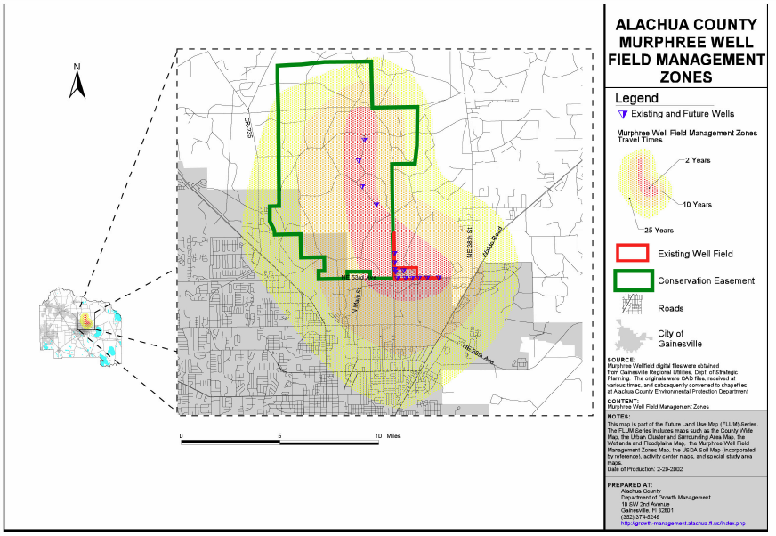
Map 2. Alachua County Floridan Aquifer High Recharge Area

Map 3. USDA Soils Map (Adopted by Reference) (part of Future Land Use Map Series)
Available online at: https://websoilsurvey.sc.egov.usda.gov/App/WebSoilSurvey.aspx
Map 4. Strategic Ecosystems, Alachua County, Florida (part of Future Land Use Map Series)
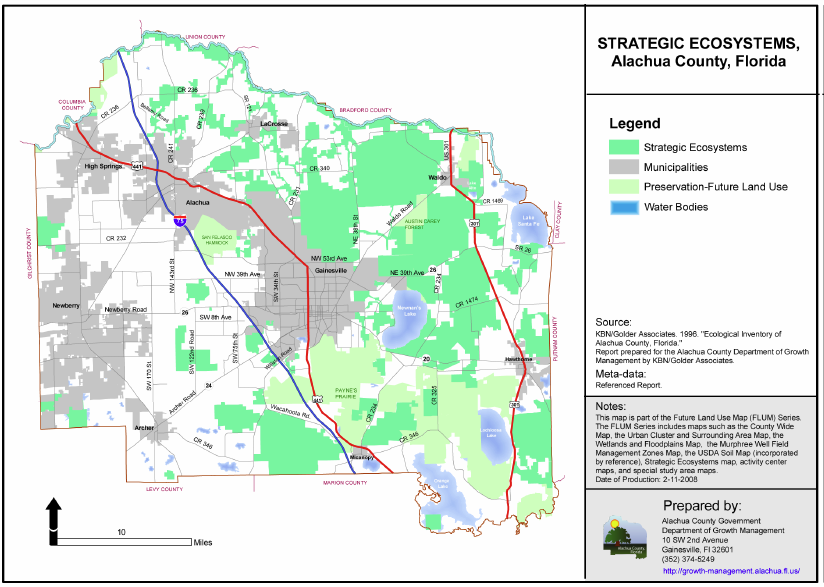
Map 5. Critical Ecological Corridors

Map 6. Devil’s, Hornsby, and Poe Springs Conceptual Priority Focus Areas (PFA)
.jpg)
Map 7. Alachua County Greenways and Blueways

Top