
The Mobility Plan
Alachua County’s Plan to Effectively Link Land Use and Transportation
Alachua County has adopted amendments to its Comprehensive Plan which will reduce vehicle miles travelled and greenhouse gas emissions per capita by providing for enhanced transportation mobility options in conjunction with land use changes that bring services closer to residents and provide for development densities and intensities that are transit supportive.
Key features of this plan include: building permits
- An alternative concurrency management system that enables new development to satisfy its transportation mitigation obligations through the payment of a multimodal transportation mitigation contribution.
- Provisions and incentives for Transit OrientedDevelopments and Traditional Neighborhood Developments that will facilitate a reduction in vehicle miles travelled per capita.
- A financially feasible multimodal infrastructure plan to accommodate future growth and transportation demands within the Urban Cluster Boundary in an fiscally efficient and ecologicallyresponsible way.
The Full Mobility Plan & Mobility Fees Technical Report can be viewed here.
EXISTING & FUTURE BICYCLE & PEDESTRIAN NETWORK
Land Use
The community our children will inherit
Urban Cluster Alachua County identified an Urban Cluster Boundary in 1991. Since that time urban densities are only provided for inside the urban cluster boundary and inside municiple boundaries.
Traditional Neighborhood
Development (TND)
The Mobility Plan encourages
TNDs which allow residents
to walk and bike to a village
center containing a mixture
of commercial, residential,
office and civic uses.
Town of Tioga is a TND.
Transit Oriented
Development (TOD)
TODs are a key feature of The
Mobility Plan. These developments
contain a mix of uses and provide
a higher density focal point for
transit.
They also will be the
location of park and ride lots to
serve residents in outlying areas.
Imagine driving a short distance,
parking, getting a cup of coffee,
checking your email as you take
transit into town, taking transit
back to your vehicle, picking up
groceries inthe village center,
and heading home for dinner.
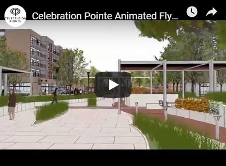
Celebraton Pointe is a Transit Oriented Development currently under development in Alachua County:
Transportation
Getting from here to there
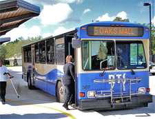
Express Transit Service
 The Mobility Plan includes
Express Transit Service from
the edges of the Urban Cluster
to UF/Shands and Downtown
Gainesville beginning in 2015.
Proposed express transit routes
serving commuting trips from
East Gainesville, Southwest
Gainesville, Jonesville
& Santa Fe College.
The Mobility Plan includes
Express Transit Service from
the edges of the Urban Cluster
to UF/Shands and Downtown
Gainesville beginning in 2015.
Proposed express transit routes
serving commuting trips from
East Gainesville, Southwest
Gainesville, Jonesville
& Santa Fe College.
EXPRESS TRANSIT CORRIDORS
Rapid Transit Service
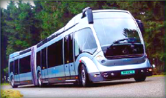 As a second phase, The Mobility
Plan includes a rapid transit
service commonly referred to as
“Bus Rapid Transit”. The primary
feature of this system is buses
running in dedicated lanes in a
“raillike” configuration. The system
will be developed in conjunction
with TODs and as density increases
within the Urban Cluster.
As a second phase, The Mobility
Plan includes a rapid transit
service commonly referred to as
“Bus Rapid Transit”. The primary
feature of this system is buses
running in dedicated lanes in a
“raillike” configuration. The system
will be developed in conjunction
with TODs and as density increases
within the Urban Cluster.
Interconnected Road Network
The Mobility Plan includes the
continued development of the
gridded roadway network as well
as addressing the bottlenecks
crossing Interstate-75.
RAPID TRANSIT CORRIDORS
Bicycle and
Pedestrian Connectivity
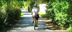 The Mobility Plan includes a
connected bicycle and pedestrian
network with new on-road bicycle
lanes and off-road multi-use
paths. These facilities will connect
existing and future residential
development to TODs, TNDs and
Activity Centers.
The Mobility Plan includes a
connected bicycle and pedestrian
network with new on-road bicycle
lanes and off-road multi-use
paths. These facilities will connect
existing and future residential
development to TODs, TNDs and
Activity Centers.
TRANSPORTATION MOBILITY AREAS
Sustainability
The How and Why of Mobility Choices
Mobility Choices: The Mobility Plan creates more mobility options for residents, especially for young people, the elderly and people who do not own cars or prefer not to drive. The Mobility Plan provides for express transit and park and ride opportunities from outlying areas into the major regional employment and commercial hubs within the City of Gainesville
Mixed Use The Mobility Plan provides for commercial, office, civic and institutional uses within walking and biking distance to residents by providing incentives for mixed-use development.
Energy Efficiency The Mobility Plan is consistent with the County’s Energy Conservation Strategies Commissions recommendations regarding land use and transportation. The plan’s focus on alternative modes of transportation and compact development patterns is key to reducing energy use, personal transportation costs and dependence on foreign-sourced fossil fuels.
Greenhouse Gases Peak hour transit service has the lowest greenhouse gas emissions of any motorized transportation mode. Bicycle and pedestrian modes are virtually greenhouse gas free.
Reduced Fiscal Impacts The Mobility Plan provides a fiscally responsible bridge to the future by positioning the County to be able to reduce future infrastructure construction and maintenance costs. The Plan focuses on the existing Urban Cluster and transitions the County from chasing congestion with new roadways to funding increased transit service over time.