
Comprehensive Plan
2019-2040
Transportation Mobility
GOAL
ESTABLISH A MULTI-MODAL TRANSPORTATION SYSTEM THAT PROVIDES MOBILITY FOR PEDESTRIANS, BICYCLISTS, TRANSIT USERS, MOTORIZED-VEHICLE USERS, USERS OF RAIL AND AVIATION FACILITIES, AND IS SENSITIVE TO THE CULTURAL AND ENVIRONMENTAL AMENITIES OF ALACHUA COUNTY.
AUTOMOBILE, BICYCLE AND PEDESTRIAN CIRCULATION
PRINCIPLE 1
TO ESTABLISH AND MAINTAIN A SAFE, CONVENIENT, AND EFFICIENT TRANSPORTATION SYSTEM FOR ALL USERS THAT IS CAPABLE OF MOVING PEOPLE AND GOODS THROUGHOUT THE COUNTY.
PRINCIPLE 2
TO REDUCE VEHICLE MILES OF TRAVEL AND PER CAPITA GREEN HOUSE GAS EMISSIONS THROUGH THE PROVISION OF MOBILITY WITHIN COMPACT, MIXED-USE, INTERCONNECTED DEVELOPMENTS THAT PROMOTE WALKING AND BICYCLING, ALLOW FOR THE INTERNAL CAPTURE OF VEHICULAR TRIPS AND PROVIDE THE DENSITIES AND INTENSITIES NEEDED TO SUPPORT TRANSIT.
PRINCIPLE 3
DISCOURAGE SPRAWL AND ENCOURAGE THE EFFICIENT USE OF THE URBAN CLUSTER BY DIRECTING NEW DEVELOPMENT AND INFRASTRUCTURE TO AREAS WHERE MOBILITY CAN BE PROVIDED VIA MULTIPLE MODES OF TRANSPORTATION.
PRINCIPLE 4
TO REPEAL TRANSPORTATION CONCURRENCY AND PROVIDE FOR AN ALTERNATIVE TO CONVENTIONAL TRANSPORTATION FUNDING SYSTEM THAT RECOGNIZES THAT CONGESTION IS ACCEPTED IN GROWING URBAN AREAS, SO LONG AS VIABLE ALTERNATIVE MODES OF TRANSPORTATION ARE PROVIDED THAT SERVE TRAVEL DEMAND ALONG CONGESTED CORRIDORS. CONGESTION ALONG SOME ROADWAYS IS THE TRADEOFF BETWEEN ADDING ROADWAY CAPACITY ON CONGESTED CORRIDORS AND DEVELOPING AN INTERCONNECTED NETWORK OF ROADWAYS, BICYCLE AND PEDESTRIAN FACILITIES AND RAPID TRANSIT FACILITIES SERVED BY EFFICIENT TRANSIT SERVICE.
1.0 TRANSPORTATION SYSTEM CAPACITY
OBJECTIVE 1.1 Urban Transportation Mobility Districts
Urban Transportation Mobility Districts encourage future land use and transportation patterns that emphasize mixed-use, interconnected developments, promote walking and biking, reduce vehicle miles of travel and per capita greenhouse gas emissions, and provide the densities and intensities needed to support transit.
Policy 1.1.1 The Urban Cluster Area as identified on the Future Land Use Map of the Comprehensive Plan shall serve as the boundary for the Urban Transportation Mobility Districts. Urban Transportation Mobility Districts shall be established for the Northwest, Southwest and Eastern portions of the Urban Cluster.
Policy 1.1.2 Urban Transportation Mobility Districts are designed to support compact, mixed-use developments provided for in the Future Land Use Element by developing an interconnected multi-modal transportation system that reduces per capita greenhouse gas emissions by encouraging walking, bicycling and driving short distances between residential, retail, office, educational, civic and institutional uses and utilizing transit to commute to regional employment, educational and entertainment destinations.
Policy 1.1.3 The intent of Urban Transportation Mobility Districts are:
(a) To provide for mobility within urban areas through the development of an interconnected network of:
(1) Roadways that provide multiple route choices, alternatives to the state road system and protect the Strategic Intermodal System (SIS).
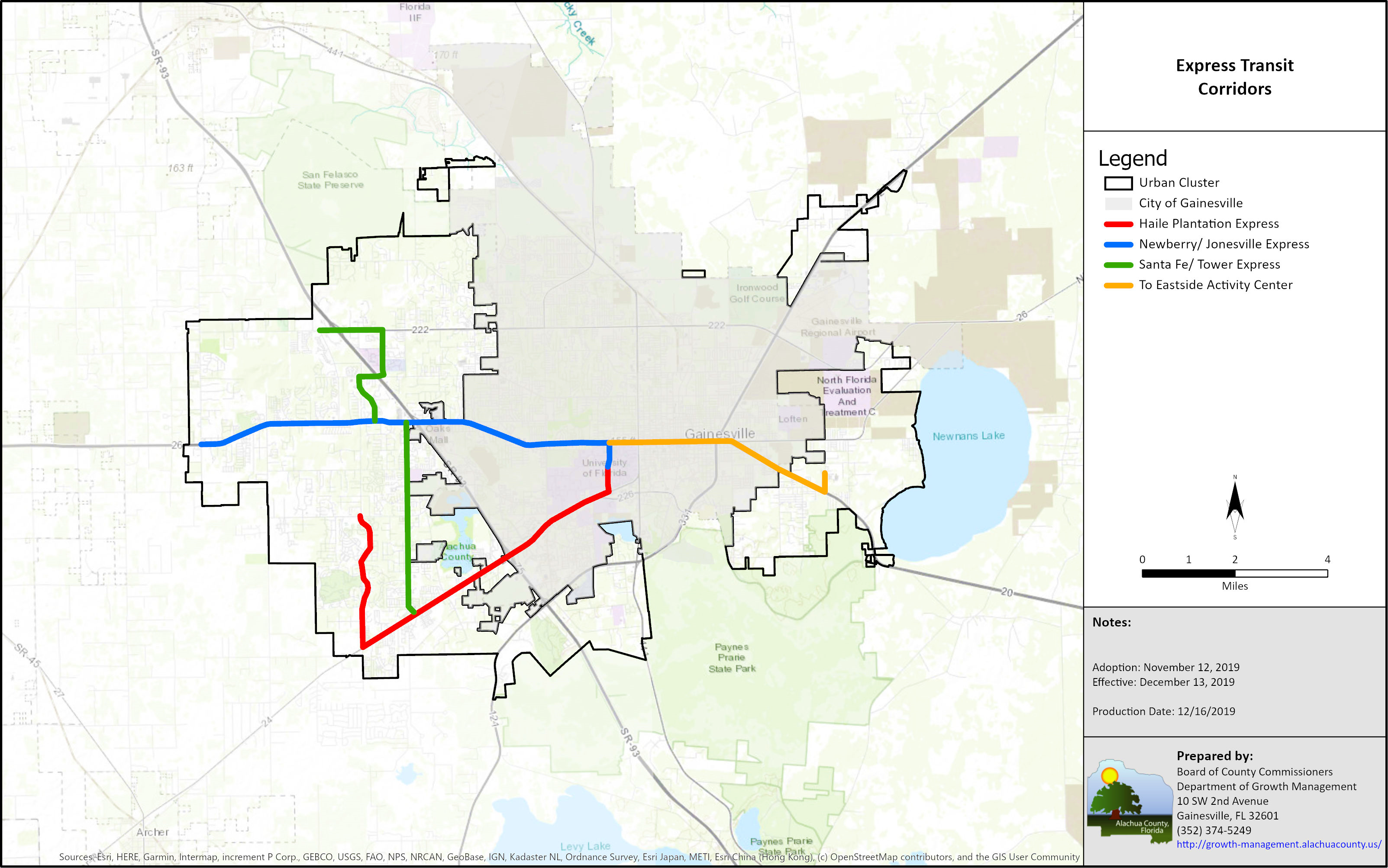
(2) Rapid Transit and Express Transit Corridors that connect Transit Oriented Developments, Traditional Neighborhood Developments and Activity Centers and facilitate efficient and cost effective transit service to regional employment, educational and entertainment destinations.
(3) Bicycle lanes, sidewalks, and multi-use paths that connect residential, commercial, office, educational and recreation uses and provide multi-modal access to transit.
(b) To recognize that certain roadway corridors will be congested and that congestion will be addressed by means other than solely adding capacity for motor vehicles and maintaining roadway level of service on those corridors.
(c) To utilize features of an alternative mobility funding system per F.S. 163.3180.
(d) Reduce vehicle miles of travel and per capita greenhouse gas emissions through compact, mixed-use, interconnected developments served by multiple modes of transportation.
(e) Reduce sprawl and encourage urban development by planning and constructing the necessary infrastructure to meet the demands for bicycle, pedestrian, transit and motor vehicle mobility.
(f) Reduce congestion within the Urban Cluster by capturing trips from surrounding rural areas, municipalities and adjacent counties through provision of park and ride facilities located within transit supportive developments in the Urban Cluster served by transit service that connects to regional employment and educational destinations.
(g) To provide for multi-modal cross-access and connectivity within and between uses to encourage walking and bicycling and reduce travel distances and impact to collector and arterial roadways.
Policy 1.1.4 Within the Urban Cluster, the County adopts multi-modal level of service (LOS) guidelines for the following:
|
|
Level of Service (LOS) |
Standard of Measure |
|
Pedestrian |
B |
Based on Presence of a pedestrian facility |
|
Bicycle |
B |
Based on Presence of a bike lanes / paved shoulders |
|
Express Transit |
B |
Based on Peak Hour Frequency of 15 minutes or less |
|
Motor Vehicle* |
D |
Professionally Accepted Traffic Analysis |
* Guideline applies to Collector and Arterial Roads
(a) In order to achieve the level of service guideline for pedestrians and bicyclists, the facility shall run the entire length of the roadway segment. A pedestrian facility shall be either a multi-use path on one (1) side of the roadway or sidewalks on both sides of the roadway. A multi-use path along a roadway shall result in a LOS B for bicyclists. The LOS for bicycle and pedestrian travel is the goal for all collector and arterial roadways within the Urban Cluster by 2040, not a standard that is intended to be achieved on an annual basis for each roadway.
(b) Express Transit Service shall be provided for a minimum of two (2) hours during both the AM and PM peak periods. The LOS for Express Transit Service shall be a goal achieved within the Urban Cluster on each of the routes shown on the Express Transit Corridors map by 2030. The peak hour frequency for each route shall be a minimum of 30 minutes and may be increased to additional service to meet demand and maintain up to fifteen (15) minute headways based on the capacity and productivity of the service.
(c) Within each Urban Transportation Mobility District, achievement of the LOS for all functionally classified roadways shall be based on an Areawide LOS. The Areawide LOS shall be determined by dividing the sum (∑) of total traffic by the sum (∑) of the total maximum service volume at the adopted LOS guideline for all functionally classified roadways.
Policy 1.1.5 Over the time horizon of the Comprehensive Plan, as the densities and intensities within the Urban Cluster necessary to support transit are realized, the County shall transition from providing new capital infrastructure for a multi-modal transportation network to providing frequent transit service along rapid transit corridors. The Twenty (20) year Multi-Modal Transportation Capital Improvements Program provides a schedule of the transition from development of the interconnected network to provision of transportation services.
Policy 1.1.6 The Multi-Modal Infrastructure Projects in the Capital Improvements Element are identified to meet the adopted level of service guidelines and proactively address projected transportation needs from new development and redevelopment within the Urban Cluster by 2040.
Policy 1.1.6.1 Updates of the Capital Improvements Element (CIE) shall include a roadway LOS analysis that demonstrates that the Areawide LOS for each Transportation Mobility District is being achieved. Updates shall also demonstrate that progress is being made toward achieving the identified bicycle, pedestrian and transit LOS. To measure and evaluate the effectiveness of the Transportation Mobility Districts policies, updates of the CIE shall also include a vehicle miles of travel (VMT) and mode share analysis for each Transportation Mobility District and the Urban Cluster.
Policy 1.1.6.2 Roadway capacity projects shall focus on the development of an interconnected network that provides alternatives to the State Road system, including the provision of additional lanes over Interstate 75.
Policy 1.1.6.3 With the exception of Interstate 75, roadways shall be limited to no more than a total of four (4) through motor vehicle lanes. All new bridges over Interstate 75 shall contain provisions for transit, bicycle lanes, sidewalks and/or multi-use paths.
Policy 1.1.6.4 The time frame for construction of the projects identified in the Capital Improvements Element is intended to be flexible to address impact from development as it occurs. Should development activity increase, then the identified projects will be constructed earlier in the time period; conversely, should development activity be below normal rates, then the construction start dates will be pushed back to a later period.
Policy 1.1.6.5 The County intends to engage in Public/Private Partnerships to develop an interconnected roadway network in undeveloped and underdeveloped portions of the Urban Cluster to accommodate both the impact from development currently allowed in the Comprehensive Plan and traffic utilizing existing roadways.
Policy 1.1.6.6 Should the Areawide LOS for motor vehicles within a Transportation Mobility District fall below adopted LOS guideline, then the County shall as a part of its update to the Capital Improvements Element either identify additional motor vehicle capacity projects or additional bicycle, pedestrian and transit projects in order to provide enhanced mobility.
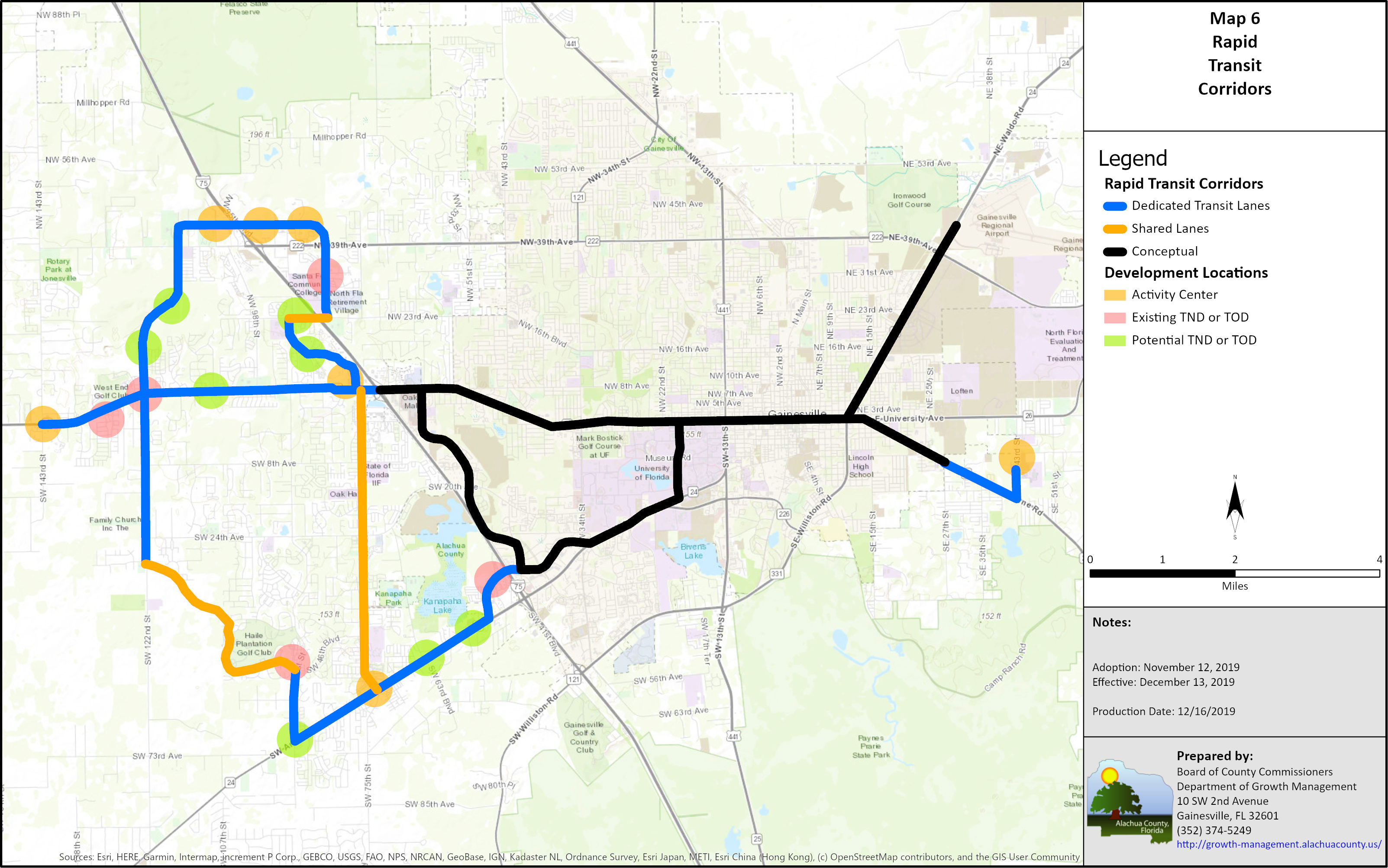
Policy 1.1.6.7 A network of corridors with dedicated transit lane(s) as shown on the Rapid Transit Corridors Map shall be developed to provide a sense of permanence and provide developers seeking to build Transit Oriented Development with the assurance that there is a commitment to transit. Dedicated Transit Lane(s) shall connect transit supportive development with regional employment, educational and entertainment centers. The design of dedicated transit lanes (s) shall be done in consultation with RTS and FDOT on State Roadways. Rapid Transit Corridors may deviate slightly from the alignment shown to serve a Transit Oriented Development, Traditional Neighborhood Development or Activity Center. A Comprehensive Plan amendment shall be required to modify dedicated transit lane(s) for transportation uses other than provision of transit service.
Policy 1.1.6.8 Dedicated transit lane(s) shall be designed and constructed in conjunction with any new roadway projects consistent with the Rapid Transit Corridors map.
Policy 1.1.6.9 The County shall coordinate the provision of park and ride facilities with transit supportive developments located along Rapid Transit Corridors consistent with the Capital Improvements Element and associated maps.
Policy 1.1.6.10 Bicycle and Pedestrian facilities shall be provided in accordance with Objective 1.6.
Policy 1.1.6.11 Large Scale Comprehensive Plan amendments to the Future Land Use Element or Map that result in a greater transportation impact shall require the entity requesting the amendment to demonstrate that the adopted LOS guidelines for the affected Urban Transportation Mobility District are achieved and that additional required infrastructure is fully funded. Applicants may only include projects that are fully funded and scheduled to commence construction within one (1) year of approval of the Comprehensive Plan Amendment.
Policy 1.1.6.12 Requests to expand the Urban Cluster Boundary, whether by public or private entities, shall require the entity to demonstrate that the adopted LOS guidelines for the affected Urban Transportation Mobility District are achieved and that additional required infrastructure is fully funded. The entity shall also be required to construct or fully fund bicycle and pedestrian facilities necessary to achieve the adopted LOS from the proposed newly included properties to an existing facility or a logical terminus within the existing Urban Cluster Boundary. Applicants may only include projects that are fully funded and scheduled to commence construction within one (1) year of approval of the request to expand the Urban Cluster Boundary. This requirement is in addition to all other conditions of the Comprehensive Plan, including Policy 7.1.3 of the Future Land Use Element in order amend the Comprehensive Plan to the expand the Urban Cluster.
Policy 1.1.6.13 For Annexations within the Urban Cluster the County shall coordinate with applicable jurisdictions to incorporate the transportation infrastructure improvements into the jurisdictions Capital Improvements Element. The County shall not expend any funds for transportation projects within annexed areas or to mitigate the impact of developments within municipalities, unless an intergovernmental agreement is established with the municipality to have developments fund their proportionate share of the cost to address the developments impact.
Policy 1.1.6.14 Amendments to projects in the Capital Improvements Element are permitted so long as it can be demonstrated that the LOS standards can be meet and that the amendment is in keeping with providing mobility by multiple modes of transportation within the Urban Cluster.
Policy 1.1.7 A mobility fee shall be adopted to ensure that a development funds mobility and fully mitigates its impact to the transportation system.
(a) Development shall satisfy transportation impact mitigation obligations through payment of a mobility fee.
(b) Modes of transportation to be addressed by the mobility fee shall be consistent with the modes identified in Policy 1.1.4.
(c) The mobility fee should reflect the potential to reduce impact to the major roadway network through an increase in internal capture of trips and increase in pedestrian, bicycle and transit mode share from Transit Oriented Developments and Traditional Neighborhood Developments, including redevelopment of existing areas consistent with design requirements for such types of development.
Policy 1.1.8 The following are internal street network requirements for all development within the Urban Cluster:
(a) Developments are required to design and construct a continuous interconnected network designed to safely calm traffic and encourage walking and bicycling throughout the development.
(b) Street design standards shall address narrow pavement and right-of-way widths, turning radii, on-street parking, and other design criteria for streets and alleys. Standards shall promote walking and biking, ensure safety for all users and allow for emergency access.
(c) A connectivity index standard shall be developed to ensure adequate internal connections as well as connections to adjacent and nearby uses. The connectivity standards shall address connectivity for bicycles, pedestrians, and motor vehicles.
(d) Stub-outs of the street network to adjacent parcels with development or redevelopment potential shall be provided. Provisions for future connections should be made in all directions whether streets are public or private, except where abutting land is undevelopable due to environmental or topographical constraints. To plan for future adaptive redevelopment of adjacent developed land, cross-access shall be provided even if a cross-access connection on the developed land does not currently exist. Cross-access connections shall be paved to the property boundary. All private streets shall provide full access to the general public.
(e) Internal streets shall connect to stub-outs provided by adjacent developments.
(f) Developments shall provide a pedestrian and bicycle circulation system that includes a network of multi-use paths throughout the development. The multi-use paths shall connect open space areas, adjacent developments, and existing or planned bicycle pedestrian facilities along collector and arterial roadways.
(g) A developer shall be allowed to propose a plan to provide a network of shared or separate facilities to provide mobility through low speed electric vehicles. The plan shall address safety for all modes of transportation with particular attention paid to bicycle and pedestrian interactions.
Policy 1.1.9 Roadways, dedicated transit lanes and trails identified in the Capital Improvements Element shall be constructed by the development where the facilities either run through or are contiguous with the development.
Policy 1.1.10 A development greater than 1,000 dwelling units or 350,000 sq ft of non-residential uses shall be required to either:
(a) Mitigate its proportionate share cost for all significant and adverse impacts to roadways, interstates, intersections and interchanges not addressed through the multi-modal transportation fee. Significant and adverse impacts to roadways, intersections, interstates and interchanges shall include all roadways where the development generates traffic that is five (5) percent or more of the Florida Department of Transportation Generalized Tables capacity at the adopted roadway level of service guideline. Adverse roadways are roadways that operate below that adopted roadway level of service guideline. The Florida Department of Transportation shall be consulted on impacts to Strategic Intermodal System (SIS) facilities, or
(b) Construct and fund multi-modal improvements, to the extent permitted by law, as described below (capital projects shall be consistent with the Capital Improvements Element):
(1) Construct one of the following:
a. Construct an overpass over Interstate 75 that accommodates at least three of the following modes of travel: walking, biking, driving or riding transit, or
b. Construct two (2) miles of an off-site roadway capacity project, or
c. Construct four (4) miles of single track or two (2) miles of dual track off-site dedicated transit lanes.
(2) Construct an off-site multi-use trail connecting two pedestrian generators.
(3) Fund four (4) hybrid or alternative fuel buses.
(4) Construct a surface park and ride lot designed to accommodate a multi-story parking structure at a future date, the multi-story parking structure may be constructed in-lieu of the surface lot.
(5) All projects, regardless of proximity to Interstate 75, shall be required to fund transit for a cumulative twenty (20) year period. The funding of transit shall be phased in such a manner to increase service frequency coincident with the construction of the development up to eventual 10 minute headways along Rapid Transit Corridors from the development site to a centrally located transit hub on the University of Florida Campus and the Eastside Activity Center. Timing of the commencement of transit service shall be scheduled to begin when there are sufficient users projected to utilize the service.
Policy 1.1.11 Developments may receive mobility fee credit for the construction of non-site related infrastructure, purchase of buses and funding of transit required in Policy 1.1.10.3. Where the cost of the required multi-modal improvements is greater than the multi-modal transportation fee, the Developer may seek reimbursement for the additional funds expended from a Community Development District (CDD)or Transportation Improvement District (TID) District. The Developer shall enter into a Development Agreement with the County to specify timing for the infrastructure projects and funding of transit service, mobility fee credit, development entitlements, and funding mechanisms.
Objective 1.2 Transportation Management Outside of Urban Cluster Mobility Areas
OBJECTIVE 1.2 - Rural Transportation Mobility Districts
To protect and support agricultural activities, preserve the character of rural communities and encourage development in areas where infrastructure can be provided in a financially feasible manner, the unincorporated area outside the Urban Cluster as identified in the Comprehensive Plan shall be established as Rural Transportation Mobility Districts. Developments within Rural Transportation Mobility Districts are required to mitigate impacts to roadways within the Rural and Urban Transportation Mobility Districts as established in the adopted Mobility Fee.
Policy 1.2.1 Alachua County shall adopt the following level of service guidelines based on daily traffic for functionally classified roadways in order to maximize the efficient use and safety of roadway facilities:
|
Mode of Travel |
Level of Service (LOS) |
|
Motor Vehicle |
C |
Policy 1.2.2 Alachua County has established level of service guidelines for rural areas to coordinate capital improvement planning and land use to ensure that growth does not occur faster than the County’s ability to provide for infrastructure in a financially feasible manner. The level of service guidelines shall not compel or require the County to widen or construct new roadways outside of the Urban Cluster in order to provide capacity to support new development or to address the unmitigated impact of development from adjacent municipalities and counties.
Policy 1.2.3 Amendments to the Future Land Use Element and/or Map, including Sector Plans and Special Area Plans, will be coordinated with the Transportation Mobility Element and the Capital Improvement Element through the evaluation of the impact of additional traffic projected to result from proposed land use plan amendments. This evaluation shall include assessment of the impact on the level of service of individual affected roads based on the roadway functional classification and number of lanes.
Policy 1.2.4 Where the evaluation of a proposed Future Land Use amendment indicates that the level of service on affected individual roads segments would be reduced below the adopted level of service guidelines, the amendment shall be accompanied by corresponding amendments to identify roadway modifications needed to maintain the existing individual segment by segment level of service guideline, as well as the scheduling of such modifications in Alachua County's Five Year Capital Improvement Program.
OBJECTIVE 1.3
To coordinate land use decisions and access locations and configurations in order to maintain and improve the efficiency and safety of the transportation system.
Policy 1.3.1 Proposed development shall be reviewed during the Development Review process for the provision of adequate and safe on-site circulation, including pedestrian and bicycle facilities, public transit facilities, access modifications, loading facilities, and parking facilities. In addition to Comprehensive Plan policies, such review shall include FDOT access management standards. Design criteria, standards, and requirements to implement this policy shall be included in the update of the land development regulations.
Policy 1.3.2 Access to roadways shall be controlled in order to maximize the efficiency of the transportation network. The FDOT Access Management Classification System and Standards shall be incorporated and utilized for reviewing plans submitted to the DRC for review and approval. All development orders shall meet at a minimum the FDOT requirements.
Policy 1.3.3 Alachua County will incorporate within their Land Development Regulations provisions which address the following:
(a) frontage road, joint access, or cross access easement requirements, where appropriate.
(b) mandatory off-street loading and parking
(c) intersection/interchange locational restrictions for land uses, including distance requirements for access cuts near intersections and interchanges
(d) building setback requirements
(e) design standards (i.e., acceleration and deceleration lanes, turning radii, signalization, etc.)
(f) intersection spacing standards
(g) minimum maintenance responsibility requirements
(h) sight distance standards
(i) incentives to mitigate poor traffic access/hazardous situations
(j) standards to eliminate traffic conflicts with bicyclists and pedestrians
(k) highway safety for all users
(l) commercial signage/utilities restrictions within rights-of-way
(m) FDOT Access Management Classification System and Standards
(n) cross-access and stub-outs to adjacent parcels
Policy 1.3.4 Development shall be required to address operational site related improvements and operational affects to adjacent major roadway intersections. Criteria shall be developed based on trip generation to determine the limits for major intersections to be addressed and the extent of required operational improvements to ensure safe operations for motor vehicles, pedestrians, and bicyclists. Operational improvements are considered site related requirements. The addition of through motor vehicle lanes not directly related to facilitating access to the site are considered capacity projects and shall be credited accordingly.
Policy 1.3.5 The land development regulations shall include standards, criteria, and procedures to ensure that an adequate system of roads functionally classified as local provides safe and maintainable access to new development that will use such roads. These regulations shall include design standards to ensure that the structural integrity and volume capacity of such roads are adequate based on projected trips to and from such development and shall take into account requirements for fire-fighting and other emergency vehicle access. Evaluation and approval of new development proposals shall include assessment of impact on and capacity of directly connected existing local roads.
Policy 1.3.6 The land development regulations shall include guidelines, standards, and procedures for the identification of existing local graded roads providing access to existing development that are deficient based on findings that the condition of such roads is below or is projected to be below that required to meet minimum standards for public safety based on factors such as accidents, indications of inaccessibility to emergency vehicles, indications of inability to properly maintain, and projected traffic volumes in relation to the condition of the road. A management program for such roads identified as deficient shall be developed by the Alachua County Public Works Department for consideration as part of the annual Capital Improvements Program update. This shall include identification of the cost of required maintenance or improvements necessary to remedy identified deficiencies, identification of existing or proposed sources of funding such expenditures, and identification of areas proposed for deferral of further development pending remedy of existing local road deficiencies.
Policy 1.3.7 Development shall be required to dedicate the necessary right-of-way proportionate to the impacts of development along property boundaries of external roadways to accommodate standard lane widths, turn lanes, bike lanes, clear recovery zones, stormwater, utilities, sidewalks and multi-use paths. Sidewalks and multi-use paths may be provided within an easement along major roadways to preserve and take advantage of proposed buffers, existing vegetation, environmentally sensitive areas, and natural features.
Policy 1.3.8 Developments that are twenty-five (25) or more residential units in size or that generate more than 250 daily trips shall provide a minimum of two (2) functional access points. Exceptions for secondary access are permitted where infeasible due to original tract dimensions, environmental or topography constraints or existing development patterns.
Objective 1.4 Future Transportation Circulation Maps (FTCM)
OBJECTIVE 1.4
To provide for support for the continued electrification of the vehicle fleet.
Policy 1.4.1 The land development regulations shall require a minimum provision of Level 2 Charging Stations (240v) be provided in new multifamily and TND/TOD developments with multifamily components.
Objective 1.5
OBJECTIVE 1.5
Avoid, minimize, and mitigate adverse impacts upon natural and historic resources and scenic quality during the siting, design, construction, operation, and maintenance of the transportation system. Use the transportation system to enhance natural and historic resources and scenic quality where possible.
Policy 1.5.1 Transportation facilities shall be located, designed, constructed, and maintained to avoid, minimize and mitigate adverse impacts Conservation and Preservation areas consistent with Objective 3.6 of the Conservation and Open Space Element.
Policy 1.5.2 Appropriate conservation, arboricultural, and horticultural standards shall be used in the design, construction, and maintenance of transportation facilities in order to promote energy conservation, enhance habitat connectivity, provide for the safe passage of wildlife, and improve scenic quality, consistent with Objectives 5.3 and 5.4 of the Conservation and Open Space Element.
Policy 1.5.3 The county determines through the adoption of this Comprehensive Plan that there is no need for, or public purpose for any new turnpikes, expressways or toll roads in Alachua County that are significantly outside of the rights of way of existing highways. This policy constitutes a finding of fact that the construction of any new expressways, turnpikes or toll roads significantly outside of existing highway rights of way by any agency of government or other entity does not serve a public purpose, and would be inconsistent with this adopted Comprehensive Plan.
OBJECTIVE 1.6
Provide a system of safe, pleasant, convenient, and continuous bicycle and pedestrian network throughout the community.
Policy 1.6.1 Transportation facilities shall be designed to result in a pleasing environment enhanced by trees and landscaping that will present an attractive community appearance, calm traffic, enhance safety, reduce heat island effects, and provide shade for pedestrians, bicyclists and transit uses. Where possible, the existing natural landscape shall be retained or appropriately replicated in roadway design so as to maintain the sense of place and environmental heritage of Alachua County.
Policy 1.6.2 The County shall strive to achieve Platinum Level Bicycle Friendly Community Status from the League of American Bicyclists.
Policy 1.6.3 Alachua County will promote the development of a multi-modal transportation system consistent with the Capital Improvements Element.
Policy 1.6.4 New development proposals shall be reviewed as part of the Development Review process for the provision of adequate and safe bicycle and pedestrian facilities consistent with policies in the Future Land Use Element. Standards and requirements for bicycle and pedestrian facilities (such as sidewalks, pedestrian paths, bicycle lanes, and bicycle parking) shall be detailed in the land development regulations and include elements such as amount, design, and location.
Policy 1.6.5 Streets and roads shall be designed such that automobile and non-automobile modes of transportation are equitably served to the greatest extent possible. Design will include public and emergency vehicle access. Such designs shall include strategies to calm automobile traffic, provide a pleasant pedestrian environment, and create safe, balanced, livable streets, such as:
(a) narrow travel lane width,
(b) minimum turning radius,
(c) bike lanes,
(d) pedestrian-friendly frontage uses and design,
(e) street trees, street furniture, and landscaping,
(f) wide sidewalks,
(g) crosswalks, and/or
(h) gridded street system of short blocks.
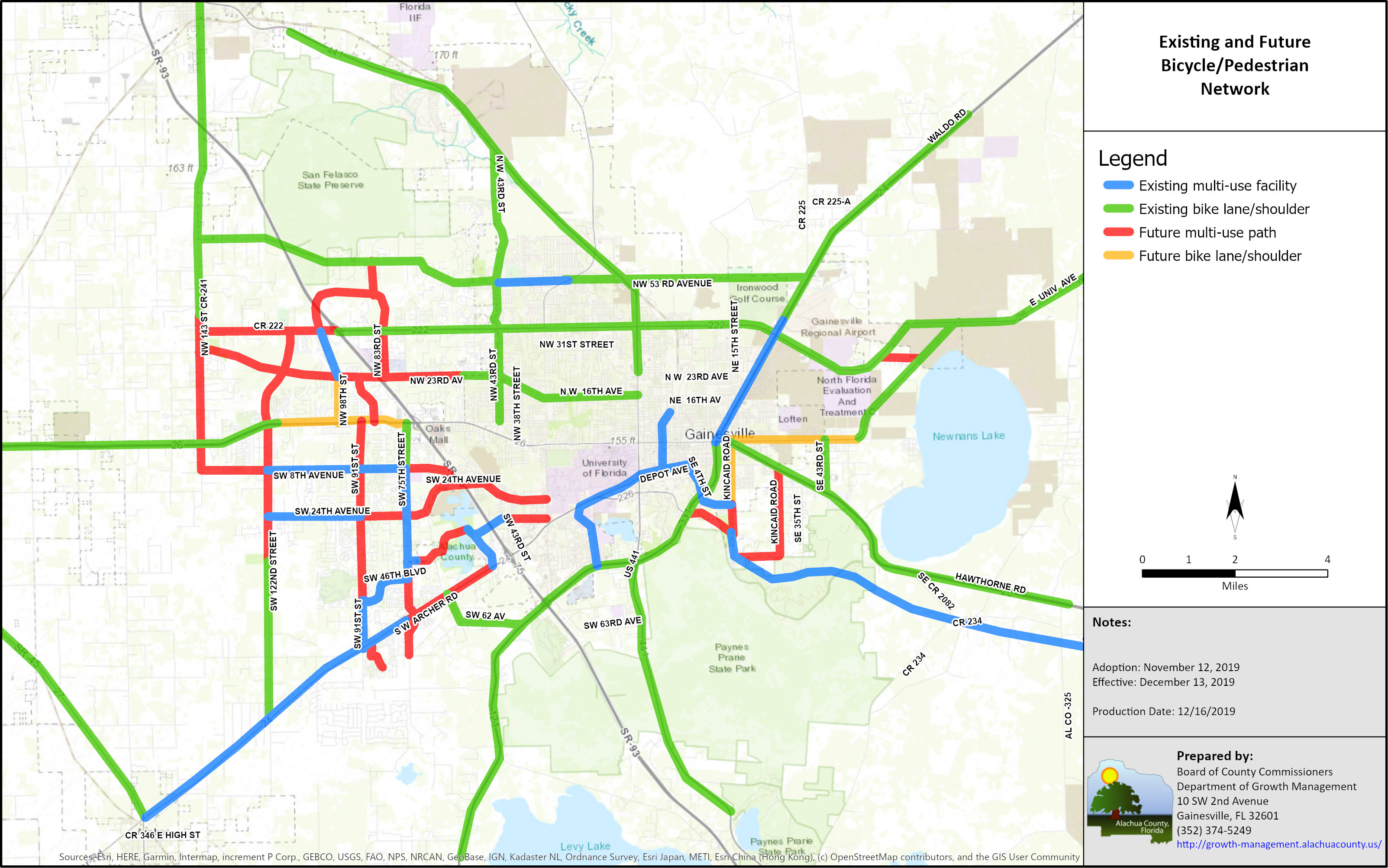
Policy 1.6.6 The preferred location for sidewalks and multi-use paths is the edge of the right-of-way, behind existing or proposed vegetation.
Policy 1.6.7 The minimum width for multi-use paths is eight (8) feet. In recognition of the difficulty in retrofitting existing roadways, the width of the multi-use path may be decreased to five (5) feet in specific locations to address utilities, stormwater facilities, and right-of-way constraints.
Policy 1.6.8 Inside the Urban Cluster, on existing open drainage collector and arterial roadways, bicycle lanes or paved shoulders shall be provided:
(a) whenever auxiliary lanes or medians are constructed unless prohibited due to stormwater, environmental or right-of-way constraints.
(b) on reconstruction projects unless prohibited due to stormwater, environmental or right-of-way constraints.
(c) with resurfacing projects unless prohibited due to stormwater, environmental, or right-of-way constraints; except where a benefit cost analysis prepared using a professionally accepted methodology considering benefits and costs that accrue to the general public as well as to the County itself does not support the installation of a paved shoulder, the County may consider an adjacent or parallel multi-use path.
Policy 1.6.9 The County shall incorporate bikeways, trails, and scenic corridors into the greenways system as provided in Objective 6.3 of the Conservation and Open Space Element.
Policy 1.6.10 Bicycle and pedestrian access for recreation and transportation throughout the community shall be incorporated into a linked open space network, or greenways system, consistent with Objective 6.3 of the Conservation and Open Space Element and the County’s Greenways Master Plan.
Policy 1.6.11 The County shall design and locate recreation sites to encourage and expand bicycle and pedestrian access consistent with the Recreation Element.
Policy 1.6.12 Developments are encouraged to utilize the sidewalk mitigation fund in lieu of constructing a sidewalk along property boundaries with an external roadway.
Objective 1.7
OBJECTIVE 1.7
To promote a comprehensive transportation planning process which coordinates state, regional, and local transportation plans.
Policy 1.7.1 In developing Alachua County's transportation plan, the following plans shall be considered:
(a) The Florida Department of Transportation's adopted Five-Year Work Program;
(b) the annual Transportation Improvement Program and Long Range Transportation Plan of the Metropolitan Transportation Planning Organization;
(c) the transportation plans of the municipalities within Alachua County; and
(d) the transportation plans of adjacent counties.
Policy 1.7.2 Alachua County will coordinate transportation modifications with state, local, and regional plans. Regional plans shall be coordinated through the MTPO for the urbanized area. For other areas of the County, transportation improvements shall be coordinated through mutual review of proposed modification programs on an annual basis with affected municipalities and the state. Alachua County shall consider the Long Range Transportation Plan in the development of its Transportation Improvement Program (TIP) for County maintained facilities in the municipalities.
Policy 1.7.3 Road projects may be constructed by private development interests to provide access to properties for the purposes of development in accordance with the Future Land Use Element. These roads must be constructed to appropriate County standards for the anticipated long-range need of the road projects.
Policy 1.7.4 In order to assess intergovernmental traffic impacts, Alachua County shall continue to coordinate with the following entities concerning the indicated facilities:
(a) the FDOT for state-maintained roads in the unincorporated area,
(b) municipalities in Alachua County for County-maintained roads within the municipality and municipal roads which may impact those County-maintained roads, and;
(c) adjacent counties for inter-county roads, where appropriate.
The coordination shall include provisions for:
(1) Periodic monitoring reports to be prepared by Alachua County for use by the FDOT in determining road modifications needs in their five-year work program.
(2) Reporting of development activity from the entity approving development orders that would result in additional traffic on County roads to monitor the capacity of County-maintained facilities and for use in capital improvement programming.
(3) Procedures for verification with the County of road capacity for developments whose approval by the entity would generate traffic exceeding more than five percent (5%) of the maximum capacity of the road based on the adopted minimum level of service guidelines.
(4) Bicycle facilities and sidewalks.
Policy 1.7.5 Alachua County shall continue to coordinate with the Florida Department of Transportation on development orders issued by the County with access to SIS and state-maintained roadways by requiring implementation of FDOT access control regulations and by involving the FDOT in the County's development review process.
Policy 1.7.6 Alachua County will continue to participate in and support the efforts of the Metropolitan Transportation Planning Organization (MTPO) through provision of the County's proposed transportation modification program to the MTPO for review, exchange of information such as traffic counts, accident data necessary for planning by the MTPO, and participation in the MTPO technical advisory committee and on the MTPO.
Policy 1.7.7 Citizen participation shall be a part of the traffic circulation planning process. This shall include, but not be limited to, citizen participation in the Capital Improvement Element review process, conducted in accordance with Policy 1.6.1 of the Capital Improvement Element.
OBJECTIVE 1.8 SAFETY
To provide a safe transportation network that supports the needs of all system users.
Policy 1.8.1 Alachua County shall strive to minimize the number of crashes resulting in fatalities and severe injuries for all transportation network users. This shall include a system wide approach.
Policy 1.8.2 The County supports a multi-disciplinary approach to safety that includes engineers, planners, law enforcement and public health representatives and other community partners. The County will establish a task force or workgroup that includes agency and community representatives to aid in identification of specific strategies that may be available to minimize the number of fatalities and severe injuries on the County’s transportation network.
Policy 1.8.3 The Board of County Commissioners shall receive a report, annually, identifying all fatalities and severe injuries that occur on the County’s roadway network. The report shall include an analysis of whether any specific system-wide improvements can be identified to reduce problem areas or corridors.
Policy 1.8.4 Alachua County recognizes the disadvantage that pedestrians and bicyclists have when crashes occur and shall work with local and State agencies to identify cost-effective improvements to the transportation network that will result in the reduction in severity of crashes.
Policy 1.8.5 It shall be the Policy of the Board of County Commissioners that speeds on County roads shall be the minimum necessary to ensure safe and efficient travel. Roads and streets shall be designed with context sensitivity using the techniques in Transportation Mobility Element Policy 1.6.5 to encourage reduced speeds. The County’s general policy shall be that proposed posted speed increases shall be brought to the Board for approval along with suggested alternatives.
Policy 1.8.6 Alachua County shall, in conjunction with the FDOT and the municipalities within the County, continue to identify and maintain data on locations of current high concentrations of crashes. This information shall be used as part of the identification of projects for Transportation System Management programs.
Policy 1.8.7 Alachua County shall develop a long range program in conjunction with the Capital Improvement Element to improve County-maintained roadways/intersections identified as having safety problems. Alachua County shall notify the FDOT of the need for modifications for safety problems identified on state-maintained roadways.
Objective 1.9
OBJECTIVE 1.9
To provide for the acquisition and protection of existing and future rights-of-way from development, including building encroachment.
Policy 1.9.1 The Future Transportation Corridor Map incorporated herein will be used to identify right-of-way needs along given transportation corridors.
Policy 1.9.2 Alachua County shall protect existing and future rights-of-way through its development review process. Rights-of-way necessary for County-maintained projects shall be acquired as soon as funds become available for such specific projects. The County will coordinate with the FDOT to determine right-of-way needs when proposed developments or modifications are adjacent to state-maintained roadways. The County will coordinate with the Regional Transit Service to determine right-of-way needs when proposed developments or modifications are adjacent to future transit corridors. Alachua County shall encourage the FDOT to acquire rights-of-way necessary for state-maintained projects as soon as funds become available for such specific projects.
Policy 1.9.3 Standards for roadway construction and development will be established as part of the land development regulations providing for the protection of existing and future rights-of-way and easements. This policy shall be applied through the County's Development Review process.
Objective 2.1 Transit
OBJECTIVE 2.1 – TRANSIT
To assist the providers of mass transit in Alachua County in their planning efforts through coordination, informational support and participation in planning efforts.
Policy 2.1.1 Alachua County will provide pertinent data to the City of Gainesville to enhance planning for the Regional Transit System (RTS) service area in the unincorporated portion of the County.
Policy 2.1.2 Alachua County shall continue to promote the enhancement of transit through the Long Range Transportation Plan.
Policy 2.1.3 Alachua County shall coordinate with the Regional Transit System (RTS) on all future transit service, express transit service, rapid transit service, and the location and design of park and ride facilities, transit stations and dedicated transit lanes.
Policy 2.1.4 Alachua County shall continue to coordinate transit issues with its municipalities, the Regional Transit System and other transportation providers, transportation disadvantaged programs, Florida Department of Transportation and Metropolitan Transportation Planning Organization.
Objective 2.2
OBJECTIVE 2.2 – Transportation Disadvantaged
To coordinate and assist the agencies planning and providing service delivery for the transportation disadvantaged.
Policy 2.2.1 Alachua County will assist the Metropolitan Transportation Planning Organization and the Florida Department of Transportation in planning services for the transportation disadvantaged.
Policy 2.2.2 Alachua County will continue to provide support for the operation of paratransit services in unincorporated Alachua County in order to provide 24-hour ambulatory and wheelchair service on a demand-responsive basis within available financial resources.
Objective 2.3
OBJECTIVE 2.3 – Rail Transportation
To promote an appropriate rail transportation system.
Policy 2.3.1 Alachua County shall promote MTPO activities to coordinate with Federal, State, regional, and local agencies to study the feasibility of a regional light rail system.
Policy 2.3.2 Alachua County shall encourage continued provision of existing freight and passenger railroad service in the County and promote the expansion of freight and passenger railroad service in the County and explore the possibility of intercity high speed rail.
3.0 AVIATION
OBJECTIVE 3.1
To coordinate improvements or expansions of aviation facilities with the Comprehensive Plan; and to prevent obstructions to airport operations.
Policy 3.1.1 The land development regulations shall provide for airport protection zoning regulations and airport land use compatibility zoning regulations in order to protect designated airport hazard areas from potential obstructions to airport operations, and to prevent incompatible land uses in the vicinity of public use airports. Such land development regulations shall be adopted or amended, as needed, administered, and enforced in accordance with the interlocal agreement for airport zoning regulations between Alachua County, the City of Gainesville, and the Gainesville-Alachua County Regional Airport Authority, as required by Chapter 333, Florida Statutes. Such land development regulations shall be based on the most current Gainesville Regional Airport Part 150 Noise Study that has been determined to be compliant by the FAA and the most current version of the Gainesville Regional Airport Master Plan.
Policy 3.1.2 Alachua County shall protect and conserve natural resources from improvements or expansions of aviation facilities, except in accordance with state and local permitting and any approved mitigation plan, consistent with the Conservation and Open Space Element.
Policy 3.1.3 Expansion of existing airport facilities or construction of new airport facilities in the unincorporated County shall be directed away from existing residential areas or areas planned for residential use, except as may be permitted by the Alachua County Board of County Commissioners in accordance with the Land Development Regulations.
Policy 3.1.4 Alachua County will notify with the Gainesville Regional Airport Authority and the Flying Ten Airport concerning proposed changes in land use within designated runway protection zones, and any application for approval of communication towers or other structures that would be more than 500 feet above mean sea level in the unincorporated portion of Alachua County. All other (private) air facilities identified in the most recent report for the Continuing Florida Aviation System Planning Process shall be notified of any application for approval of communication towers or other structures that would be more than 500 feet above mean sea level in the unincorporated portion of Alachua County.
Policy 3.1.5 Surface transportation access to aviation facilities shall be coordinated with the traffic circulation system shown on the traffic circulation maps.
Policy 3.1.6 Alachua County shall coordinate its transportation planning efforts with the Gainesville-Alachua County Regional Airport Authority, the City of Gainesville, the Gainesville-Alachua County Metropolitan Transportation Planning Organization, and the Florida Department of Transportation, in order to address the impacts of planned airport expansions on transportation needs.
Objective 3.3
OBJECTIVE 3.2
To coordinate the capital improvement plans associated with aviation facilities of the Federal Aviation Administration, the Florida Department of Transportation, the Gainesville-Alachua County Metropolitan Transportation Planning Organization, the City of Gainesville, Alachua County, and the Multi-County Regional Airport Task Force.
Policy 3.2.1 Fiscal impacts for improvements or expansions of aviation facilities, as well as transportation plans impacted by such improvements or expansions, shall be reflected in the applicable budgets of the Federal Aviation Administration, the Florida Department of Transportation Five-Year Transportation Plan, the Gainesville-Alachua County Metropolitan Transportation Planning Organization, and the Alachua County Capital Improvement Element.
Policy 3.2.2 The County shall encourage and support appropriate funding applications submitted by the Airport Authority to the appropriate agencies.
Policy 3.2.3 Improvements or the expansion of airport facilities shall be coordinated with the necessary expansion or modifications to the traffic system to support the facility.
Policy 3.2.4 The costs and funding sources for right-of-way acquisition and road improvement projects needed to meet the impact of airport facilities on the traffic circulation plan shall be reviewed and taken into account in the annual update of the Alachua County Capital Improvement Program.
Transportation Mobility Element Map Series
1. Future Transportation Functional Classifications (2025)
2. Future Transportation Functional Classifications (2040)
3. Future Transportation Circulation Map (Number of Traffic Lanes) (2025)
4. Future Transportation Circulation Map (Number of Traffic Lanes) (2025)
5. Express Transit Corridors
6. Rapid Transit Corridors
7. RTS Routes
8. Existing & Future Bicycle and Pedestrian Network
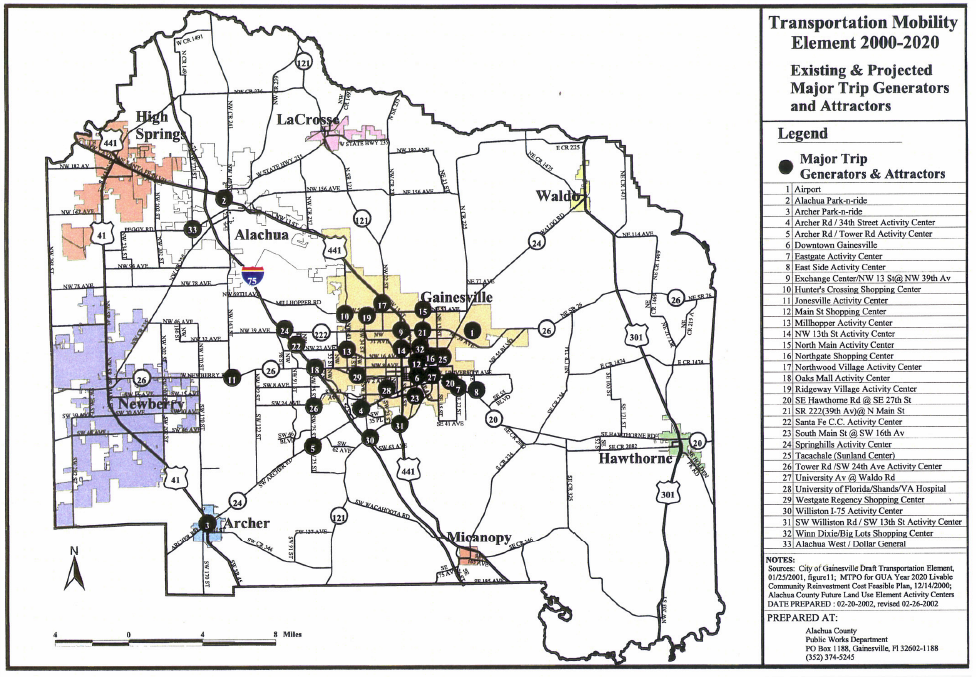
9. Existing and Projected Major Trip Generators and Attractors
10. Transportation Mobility Districts
Future Aviation and Related Facilities Map Series
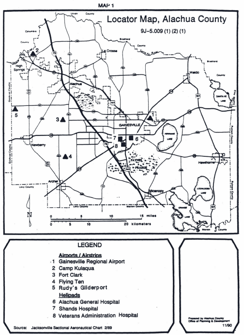
11. Air Facilities Locator Map, Alachua County
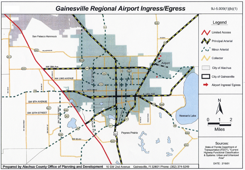
12. Gainesville Regional Airport Ingress/Egress
Map 1. Future Transportation Functional Classifications (2025)
.jpg)
Map 2. Future Transportation Functional Classifications (2040)
.jpg)
Map 3. Future Transportation Circulation Map (Number of Traffic Lanes) (2025)
.jpg)
Map 4. Future Transportation Circulation Map (Number of Traffic Lanes) (2025)
.jpg)
Map 5. Express Transit Corridors
Map 6. Rapid Transit Corridor
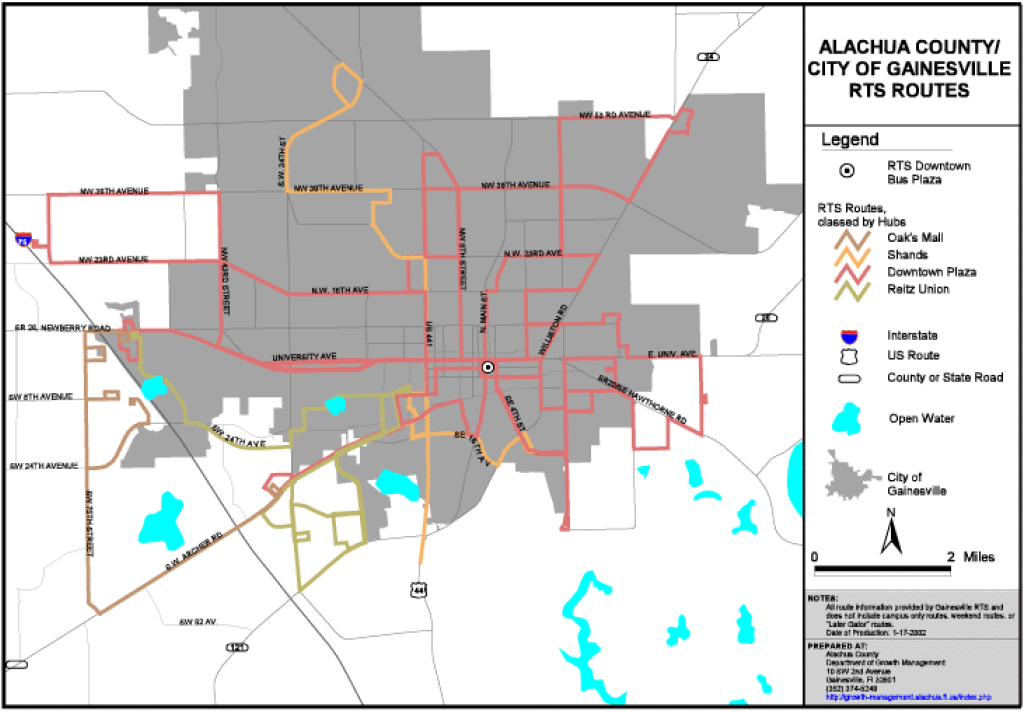
Map 7. RTS Routes
Map 8. Existing & Future Bicycle and Pedestrian Network
Map 9. Existing and Projected Major Trip Generators and Attractors
Map 10. Transportation Mobility Districts

Map 11. Air Facilities Locator Map, Alachua County
Map 12. Gainesville Regional Airport Ingress/Egress
Top