
Comprehensive Plan
2019-2040
Future Land Use - Page 1
GOAL
ENCOURAGE THE ORDERLY, HARMONIOUS, AND JUDICIOUS USE OF LAND, CONSISTENT WITH THE FOLLOWING GUIDING PRINCIPLES.
PRINCIPLE 1
PROMOTE SUSTAINABLE LAND DEVELOPMENT THAT PROVIDES FOR A BALANCE OF ECONOMIC OPPORTUNITY, EQUITY, ENVIRONMENTAL JUSTICE, AND PROTECTION OF THE NATURAL ENVIRONMENT.
PRINCIPLE 2
BASE NEW DEVELOPMENT UPON THE PROVISION OF NECESSARY SERVICES AND INFRASTRUCTURE. FOCUS URBAN DEVELOPMENT IN A CLEARLY DEFINED AREA AND STRENGTHEN THE SEPARATION OF RURAL AND URBAN USES.
PRINCIPLE 3
RECOGNIZE RESIDENTIAL NEIGHBORHOODS AS A COLLECTIVE ASSET FOR ALL RESIDENTS OF THE COUNTY.
PRINCIPLE 4
CREATE AND PROMOTE COHESIVE COMMUNITIES THAT PROVIDE FOR A FULL RANGE AND MIX OF LAND USES.
General Strategies to implement these Principles include:
GENERAL STRATEGY 1
Minimize the conversion of land from rural to urban uses by maximizing the efficient use of available urban infrastructure, while preserving environmentally sensitive areas, according to the following:
· Designate and maintain on the Future Land Use Map an urban cluster that sets a boundary for urban growth.
· Provide incentives for higher average densities for residential development and mixed uses in the urban cluster, including density bonuses and transfer of development rights.
· Provide a range of urban residential densities with the highest densities located in or near urban activity centers, and lower densities located in outlying rural areas or areas of the County which have physical limitations to development.
· Utilize mechanisms such as land acquisition, conservation easements, variable lot sizes, and conservation subdivisions.
· Preserve ecosystems of a given area and incorporate hazard-resilient land planning.
· Time development approval in conjunction with the economic and efficient provision of supporting community facilities, urban services, and infrastructure, such as streets, utilities, police and fire protection service, emergency medical service, mass transit, public schools, recreation and open space, in coordination with policies in the Capital Improvements Element.
GENERAL STRATEGY 2
Promote land development that maximizes the use of public investments in facilities and services, ensures a proper level of public services for all new development, and preserves existing amenities. Land use decisions shall be made consistent with public facility improvements which shall be provided in accordance with the following priorities:
· in areas where the lack of public facilities threatens the health and safety of the community;
· in urban areas that are lacking adequate public facilities to meet the needs of existing development and to encourage infill development, and mixed-use redevelopment;
· in new areas which are part of a planned expansion of public services to encourage growth; and
· to extend individual services to meet the demands created by a specific development.
GENERAL STRATEGY 3
Promote the spatial organization of neighborhoods, districts, and corridors through urban design codes, incorporating graphics that serve as predictable guides for community development. Implementation shall be through a combination of standard requirements and incentives, creating a planning framework that includes provisions to:
· Create neighborhoods that are compact, connected to adjacent development, have limited mixed uses at centers, and have interconnected, mixed modal streets with pedestrian, bicycle, and transit friendly areas.
· Integrate civic, institutional, and commercial activity in neighborhoods and districts, not isolated in remote, single-use complexes.
· Avoid large areas of single-use, similar densities, and similar types of units. A diverse mix of land uses, housing types and costs and densities shall be promoted. Identify locations or districts where special or single use activities shall be allowed or restricted (e.g., large scale retail or industrial areas).
· Link corridors that are regional connectors of neighborhoods and districts, ranging from parkways and transit lines to watersheds and greenways.
· Provide for infill where appropriate.
1.0 URBAN RESIDENTIAL POLICIES
OBJECTIVE 1.1 – GENERAL
Encourage development of residential land in a manner which promotes social and economic diversity, provides for phased and orderly growth consistent with available public facilities, and provides for access to existing or planned public services such as schools, parks, and cultural facilities.
Policy 1.1.1 Adequate locations shall be available in the urban cluster for all types of housing including the placement of manufactured homes, and manufactured home parks and subdivisions.
Policy 1.1.2 Urban Residential development situated adjacent to Interstate 75 shall be adequately buffered to attenuate traffic noise.
Policy 1.1.3 Urban Residential development shall be consistent with the Conservation policies of Alachua County.
Policy 1.1.4 Higher urban densities than designated on the Future Land Use Map may be allowed for housing as established by policies in the Housing Element of the Comprehensive Plan.
Policy 1.1.5 Master planning of all contiguous land under common ownership or control is strongly encouraged.
OBJECTIVE 1.2 - LOCATION, MIX OF USES, AND IMPLEMENTATION CONSISTENT WITH MARKET DEMAND
Provide for adequate future urban residential development that includes a full range of housing types and densities to serve different segments of the housing market, designed to be integrated and connected with surrounding neighborhoods and the community, with opportunities for recreation and other mixed uses within walking or bicycling distance.
Policy 1.2.1 Residential areas shall allow mixed uses in traditional neighborhood developments free from the influence and encroachment of incompatible land uses, such as heavy industrial, and inappropriately scaled or designed developments, such as large-scale retail. In mixed use traditional neighborhood developments, appropriately scaled and designed non-residential land uses are compatible with single family or multi-family residential development. Mixed use traditional neighborhood developments shall be allowed in residential zoning districts and through the planned development process.
Policy 1.2.1.1 Residential areas shall be designed to provide for an interconnected system of internal circulation, including the provision of streets dedicated to the public connecting the residential area to the major street system. New development shall not preclude public access to the development. Residential areas shall also be designed to provide for substantial interconnectivity between adjacent developments and within developments, except where such connectivity is precluded by constraints resulting from physical layout of existing development or environmental features. The land development regulations shall detail the requirements for public access and substantial interconnectivity based on standards such as a connectivity index, maximum separations between connections to adjacent developments, and rules relative to hours, operations, and public safety considerations for any restriction of access through use of gates.
Policy 1.2.1.2 Landscapes, buffers, natural areas or transitional development practices shall be utilized in site planning to lessen impacts and integrate development along the edges of different land use categories, screen undesirable views, preserve tree canopy and vegetation in accordance with the Conservation and Open Space Element, and facilitate the safe movement of traffic and pedestrians in vehicle use areas. Such practices may take the form of any combination of the followi
(a) undisturbed natural areas of non-invasive trees and plants;
(b) landscaped open spaces with canopy trees and under-story trees and plants;
(c) physical elements that do not impede the interconnectivity of pedestrian, bicycle, and automobile facilities, such as landscaped screens, walls, or fences; or
(d) development practices to use massing, scale of structures, design, and transitions of intensity of uses to provide for building types, building sizes, and activities that are similar to or compatible with the character of the surrounding neighborhood and community.
Policy 1.2.2 The Unified Land Development Code shall contain regulations to preclude detrimental airport noise impact on residential areas and to protect the public's investment in the Gainesville Regional Airport. New residential development should be allowed only under certain conditions within the Noise Contour (DNL) lines as shown on the noise exposure map included in the most current Part 150 Noise Study for Gainesville Regional Airport that has been determined to be compliant by the FAA.
Policy 1.2.3 Residential care facilities shall be allowed in residential areas and shall be designed and located to maintain compatibility with the existing residential character of neighborhoods, and shall be sufficiently dispersed to afford clients the opportunity for community integration and to avoid the concentration of residential care facilities.
Policy 1.2.4 All new residential development in the urban cluster shall:
(a) be economically and efficiently served by supporting community facilities, and services such as streets, utilities, public educational facilities, and public protection.
(b) connect to centralized potable water supply and sanitary sewer systems in accordance with Policy 2.1.1 of the Potable Water and Sanitary Sewer Element.
OBJECTIVE 1.3 – DENSITY
Gross residential densities shall be established to serve as a guideline for evaluating development in Alachua County.
Policy 1.3.1 Gross residential densities shall be used for the following reasons:
(a) In order to plan for public facilities and services such as schools, sewers, fire protection, parks, roads, and storm water management , the total number of persons living in an area must be known; while, the density of specific development sites is less significant.
(b) For any given area with the same gross residential density, the total number of dwelling units ‑ which relates to population ‑ would remain the same regardless of the type of development or the distribution of land uses in that area. Thus, gross residential density allows greater flexibility of housing types in each area.
(c) The concept of gross density encourages developers to allocate land for public facilities, such as schools, fire stations, roads, storm water management and parks, without being penalized for reduction in total dwelling units.
(d) Gross residential density provides the developer with incentives to reduce overall site and housing costs, as well as to provide for more innovative design than is possible under conventional (net density) development.
(e) Gross density encourages the protection of undevelopable conservation areas through the transfer of dwelling units on the property. However, there may be instances where the resulting net density will be inappropriate for a given site. These proposals shall be reviewed on an individual case basis.
Policy 1.3.2 The following classification of gross residential densities shall serve as a standard for evaluating development in Alachua County, unless specific provisions are otherwise provided in the Plan (DU/Acre = Dwelling Units per Acre), such as for Transit Oriented Developments and Traditional Neighborhood Developments.
Policy 1.3.2.1 Urban Residential Densities ‑ Areas designated on the Future Land Use Map for gross residential densities of one unit per acre or greater shall be considered as urban in character. There shall be four gross residential density ranges as follows:
(a) Low Density: One to Four dwelling units per acre
(b) Medium Density: Greater than Four to less than or equal to Eight dwelling units per acre
(c) Medium‑High Density: Greater than Eight to less than or equal to 14 dwelling units per acre
(d) High Density: Greater than 14 to less than or equal to 24 dwelling units per acre
Policy 1.3.2.2 Estate Residential - The Estate Residential designation, with a maximum density of one dwelling unit per two acres, shall only be located in the urban cluster on properties adjacent or near Preservation areas, as identified on the Future Land Use Map, as a transitional land use to higher intensity or density urban development.
Policy 1.3.3 A range in urban residential densities should be provided with the highest densities located in or near urban activity centers and transit oriented developments, and lower densities located in outlying areas or areas of the County which have physical limitations to development.
Policy 1.3.4 The gross residential densities of new subdivisions and multi-family developments shall not be less than the urban residential density range for the assigned future land use category except where necessary to protect natural resource conservation areas as identified in Objective 3.1 of the Conservation and Open Space Element. With regard to land designated Low Density Residential (1-4 DU/acre) on the Future Land Use Map, an exception may be made for subdivisions with gross densities of one dwelling unit per two acres with lots as small as one dwelling unit per acre, if it is determined that severe environmental site constraints, infrastructure constraints, or parcels of limited scale preclude achieving a gross density of one unit per acre. However, nothing in this policy shall be interpreted to preclude single-family residential construction on one or two new parcels, each not exceeding 5 acres, where such parcels are divided from a parcel of record (as of October 2, 1991) when such division is not subject to subdivision regulations.
Policy 1.3.5 Within areas designated Low Density Residential (1-4 DU/acre) on the Future Land Use Map, the Agriculture zoning district may be maintained pursuant to the following requirements:
(a) The parcel contains a minimum of 40 acres;
(b) The property has a bonafide agricultural use which is evidenced by maintenance of an agricultural exemption for ad valorem tax purposes.
(c) Two new parcels of 5 acres or less may be created from such Agricultural parcels. Any further division shall be subject to rezoning to an Urban Residential zoning classification, compliance with minimum density requirements, and compliance with applicable subdivision regulations.
ACCESSORY DWELLING UNITS
Policy 1.3.6 To provide for a greater range of choices of housing types in single family residential areas, affordable housing, and the promotion of infill to new and existing neighborhoods while maintaining single family character, one accessory dwelling unit shall be allowed on single family residential lots in the Estate, Low, and Medium Density residential areas without being included in gross residential density calculations. Performance criteria shall be detailed in the land development regulations and include elements such as size, site design, landscaping, access, and parking requirements.
Policy 1.3.6.1 Prior to the issuance of a building permit for the construction of an accessory dwelling unit in an existing residential area, the applicant shall provide proof of homestead exemption status establishing ownership and principal residence of the lot. Prior to the issuance of a building permit for the construction of an accessory dwelling unit(s) in a new residential development, the applicant shall provide proof of deed restrictions or covenants requiring that an accessory unit may not be inhabited unless homestead status is maintained on the lot. Permanent occupancy by the owner of either the primary or accessory dwelling unit shall be required for all accessory dwelling units.
Policy 1.3.6.2 All accessory dwelling units shall be required to connect to the municipal potable water and sewer system of the primary residence and shall not have separate services. Where central water and sewer service is not available, the accessory dwelling unit shall be required to connect to the septic system and well of the primary residence in accordance with all applicable requirements of the Florida Department of Health. The septic system shall meet the residential lot requirements for well and septic provided in the land development regulations.
URBAN RESIDENTIAL DENSITIES
Policy 1.3.7 Low Density Residential land use category shall provide for a gross density of one to four dwelling units per acre except as provided for in Cottage Neighborhoods, Transit Oriented Development (TOD) and Traditional Neighborhood Development (TND) meeting the requirements of this Element.
Policy 1.3.7.1 Low Density residential land use category shall provide for single residential detached and attached dwellings. In addition, traditional neighborhood developments (TND), transit oriented developments (TOD) and planned developments may include mixed housing types and mixed uses.
Policy 1.3.7.2 The Low Density residential land use category shall provide for various housing types, such as conventional site-built single family homes, accessory living units, attached structures including townhouses, multi-family developments in planned developments, dwellings with zero lot line orientation, factory-built modular units, manufactured homes, or mobile homes.
Policy 1.3.7.3 The County’s Land Development Regulations shall allow Low or Medium density residential land use to include flexible and mixed minimum lot sizes, relying on design standards and gross density. Such provisions shall address the need for affordable housing, compatibility with transit alternatives, and open space preservation including greenway corridors.
Policy 1.3.8 Medium Density Residential land use category shall provide for a gross density of four to eight dwelling units per acre except as provided for in Cottage Neighborhoods, Transit Oriented Development (TOD) and Traditional Neighborhood Development (TND) meeting the requirements of this Element.
Policy 1.3.8.1 Medium Density residential development shall provide for small lot single family residential detached and attached dwellings, and multi-family residential dwellings. In addition, traditional neighborhood developments (TND), transit oriented developments (TOD) may include mixed housing types and mixed uses.
Policy 1.3.8.2 Multi‑family development outside a TND or TOD in the Medium Density Residential land use category shall:
(a) have direct access to an arterial or collector, or alternate access if the access meets the following requirements and is approved by the Board of County Commissioners:
(1) The character of the primary access street should not be single family residential in nature and use of the street for multi-family development shall not create an adverse impact on surrounding properties.
(2) The access street shall generally meet the criteria for an arterial or collector street in an Urban Activity Center including the design elements found in the Alachua County Corridor Design Manual.
(b) provide natural and landscaped open spaces, or transitional development and design practices, to adequately integrate the development along the edges of different land use categories.
(c) provide common open space as part of open space requirements established in the Conservation and Open Space Element.
(d) provide adequate developed recreation at the scale of the development, according to criteria in the land development regulations.
Policy 1.3.8.3 The Medium Density residential land use category shall provide for various housing types, such as conventional, site-built single family dwellings, accessory living units, attached structures including townhouses, dwellings with zero lot line orientation, factory-built modular units, manufactured homes, mobile homes, or multi-family dwellings.
Policy 1.3.8.4 Medium density residential areas shall be located in the urban cluster.
Policy 1.3.9 Medium High Density Residential land use category shall provide for a gross density of eight to 14 dwelling units per acre, except as provided for in Transit Oriented Development (TOD) and Traditional Neighborhood Development (TND) meeting the requirements of this Element.
Policy 1.3.9.1 The Medium-High Density residential land use category shall provide for small lot single family residential detached and attached dwellings, and multiple family residential dwellings. In addition, traditional neighborhood developments (TND) and transit oriented developments (TOD) may include mixed housing types and mixed uses.
Policy 1.3.9.2 Multi-family development outside a TND or TOD in the Medium-High Density Residential, land use category shall:
(a) Have direct access to an arterial or collector, or alternate access if the access meets the following requirements and is approved by the Board of County Commissioners:
(1) The character of the access street should not be single family residential in nature and use of the street for multi-family development shall not create an adverse impact on surrounding properties.
(2) The access street shall generally meet the criteria for an arterial or collector street in an Urban Activity Center including the design elements found in the Alachua County Corridor Design Manual.
(3) The land development regulations have been updated with specific criteria to be met for approval of an alternate access road.
(b) Provide natural and landscaped open spaces, or transitional development and design practices, to adequately integrate the development along the edges of different land use categories.
(c) Provide common open space as part of open space requirements established in the Conservation and Open Space Element.
(d) Provide adequate developed recreation at the scale of the development, according to criteria in the land development regulations
Policy 1.3.10 High Density Residential shall provide for a gross density of 14 to 24 dwelling units per acre.
Policy 1.3.10.1 High Density Residential development should occur within transit oriented developments in activity centers and immediately adjacent to Santa Fe Community College to reduce the length and number of automobile trips. High density residential areas shall be located in the urban cluster.
Policy 1.3.10.2 The High Density Residential land use category shall provide for small lot single family residential detached and attached dwellings, and multiple family residential dwellings. In addition, transit oriented developments (TOD) may include mixed housing types and mixed uses.
Policy 1.3.10.3 High Density Residential outside of a TOD development shall:
(a) Have access to an arterial or collector.
(b) Provide natural and landscaped open spaces, or transitional development and design practices, to adequately integrate the development along the edges of different land use categories.
(c) Provide common open space as part of open space requirements established in the Conservation and Open Space Element.
(d) Provide adequate developed recreation at the scale of the development, according to criteria in the land development regulations.
(e) Provide transit facilities, if warranted based on existing or planned transit service determined through consultation with the appropriate transit provider, and connect pedestrian facilities into the nearest pedestrian network and available or planned mass transit facility.
Policy 1.3.10.4 Densities higher than 24.00 DU/Acre may be considered in activity centers and within developments that meet the standards for Traditional Neighborhood Development as provided in Objective 1.6 and subsequent policies, Transit Oriented Development as provided in Objective 1.7 and subsequent policies, and within residential or mixed-use developments that qualify for a density bonus by providing affordable housing as detailed in the Land Development Regulations.
OBJECTIVE 1.4 – NEIGHBORHOOD DESIGN AND SITE STANDARDS
Encourage the use of innovative concepts for residential development to allow for appropriate mixes of housing types and mixed-use development within Traditional Neighborhood and Transit Oriented Development, adequately served by necessary supporting facilities, in an efficient, environmentally sensitive, and attractive manner.
Policy 1.4.1 The use of proven, innovative concepts for residential development such as TND and TOD are strongly encouraged.
Policy 1.4.1.1 Appropriate mixes of housing types shall be allowed where such mixes may be integrated with the character of the surrounding residential area.
Policy 1.4.1.2 Existing or planned supporting facilities and utilities shall be adequate to serve proposed densities.
Policy 1.4.1.3 Planned developments, subdivisions, traditional neighborhood developments and transit oriented developments designed for phasing shall embody proper access, circulation, drainage, open space and utilities for each phase to ensure viability at all stages of development.
Policy 1.4.1.4 Urban development shall incorporate design techniques to promote integration with adjacent neighborhoods and enhance the quality of the living environment. Such design techniques shall include:
(a) Quality design practices, transitional intensity (types of uses), stepped density, buffering, boundaries, landscaping, and natural open space.
(b) Open space shall be designed to be accessible as required by Conservation and Open Space Policy 5.2.3 and Stormwater Management Element Policy 5.1.11. Open space requirements fulfilled through the use of conservation resource areas per Conservation and Open Space Element Policy 5.2.2 shall incorporate accessible open space, to the extent consistent with the character and protection of the resource.
(c) Special attention shall be provided to the design of development and neighborhood edges, which shall be designed to be integrated into the surrounding community.
Policy 1.4.2 Residential developments of mixed housing types may be allowed through the development review process provided the development is consistent with Comprehensive Plan policies, Land Development Regulations, and provides:
(a) A pedestrian and bicycle friendly environment that encourages walking and bicycling as a primary means of mobility within the development,
(b) A gridded street network that allows for multiple route choices, reduces the distance between uses to encourage walking and biking, accommodates transit service and connects with adjacent developments,
(c) On-street parking and screening of off-street surface parking.
OBJECTIVE 1.5 – REQUIRED FACILITIES
All new residential development shall meet the requirements for adequate facilities as established or referenced in this section.
Policy 1.5.1 New residential development shall meet all of the requirements for adequate facilities based on the level of service standards adopted in this Plan for roads, potable water, sanitary sewer, solid waste, stormwater, public schools, recreation and open space facilities, and mass transit and the concurrency provisions of this Plan.
Policy 1.5.2 In addition to the facilities for which level of service standards are adopted as part of the concurrency management system of this Plan, other facilities that should be adequate to serve new urban residential development include:
(a) local streets;
(b) police, fire and emergency medical service protection;
(c) pedestrian and bicycle network; and
(d) primary and secondary schools.
Policy 1.5.3 New residential developments shall provide for the provision of high speed internet access as specified in the land development regulations.
OBJECTIVE 1.6 – TRADITIONAL NEIGHBORHOOD DEVELOPMENTS
To provide for interconnected, mixed-use development through specific site and design standards that create pedestrian and bicycle friendly communities, reduce per capita greenhouse gas emissions and vehicular trips on external roadways and provide development patterns that are transit supportive.
Policy 1.6.1 Traditional Neighborhood Developments shall be:
(a) Allowed in areas designated on the Future Land Use map for Urban Residential Densities (Policy 1.3.2.1) and Activity Centers within the Urban Cluster,
(b) At least 15 acres in size,
(c) Allowed through the development plan review process consistent with the Comprehensive Plan and Land Development Regulations.
Policy 1.6.2 Public Participation. A public involvement process shall be used for establishing Traditional Neighborhood Developments. The process shall include a neighborhood workshop or other similar forum to inform surrounding neighborhoods of the scope, scale, and character of services and impacts from the proposed village center, and to inform the developer of neighborhood concerns. The workshop will help to identify common interests as well as concerns and differences.
Policy 1.6.3 Traditional Neighborhood Developments shall provide:
(a) A village center, as provided in Policy 1.6.4 and subsequent policies,
(b) Compact, mixed-use development to allow for the internal capture of pedestrian, bicycle and vehicular trips,
(c) A pedestrian and bicycle friendly environment that encourages walking and bicycling as a primary means of mobility within the development and between adjacent developments,
(d) A gridded street networks that emanates from the village center that allows for multiple route choices, reduces the distance between uses to encourage walking and biking, accommodates transit and connects with adjacent developments,
(e) On-street parking and screening of off-street surface parking.
Policy 1.6.4 Village Centers. Traditional Neighborhood Developments shall be required to have compact, definable mixed use, pedestrian and bicycle friendly village centers that offer multiple destinations and reasons for pedestrians and bicyclist to frequent the area.
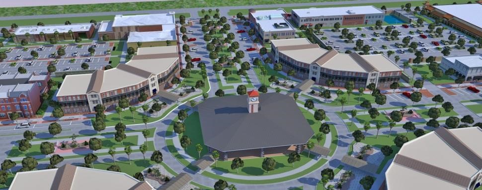
Policy 1.6.4.1 The village center shall offer a mixture of uses and community gathering spaces to attract pedestrians and bicyclists and serve as the focal point of the development. The highest density, intensity and mixture of uses shall be located within the village center and emanate from the village center along a gradient suitable to the site and surrounding land uses.
Policy 1.6.4.2 Plazas, squares, and open spaces that function as community gathering places shall be located within the village center and interspersed throughout the development. Plazas, squares and open space within the village center should be appropriately sized to maintain urban character, pedestrian scale, and compatibility with the typical block lengths provided in the village center.
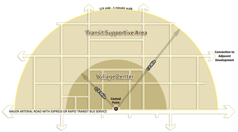
Policy 1.6.4.3 A central point located in a plaza, square, open space or denoted by an architecturally significant feature, shall be established as part of the development. The central point shall be the location from which policies related to the measurements of village centers and transit supportive areas are derived.
Policy 1.6.4.4 The maximum extent of the village center shall generally be a 1/8 mile radius in size utilizing a block or radial pattern, measured from the central point of the village center. The maximum extent of the transit supportive area, inclusive of the village center, shall generally be a 1/4 mile radius in size utilizing a block or radial pattern measured from the central point of the village center. The village center and transit supportive area boundaries may be limited in size due to environmental, topographical or physical constraints and shall not extend beyond the developments property boundary. Some flexibility may be provided within the Land Development Regulations (LDRs) for the standards regulated by these designations to allow for irregular shaped parcels, environmental, topographical or physical constraints and appropriate transition zones, provided the result is consistent with the general requirement to provide a walkable and bikeable environment that supports transit.
Policy 1.6.4.5 The primary orientation for a village center is internal to the development. Any portion of the village center oriented to major external roadways shall provide for an enhanced pedestrian environment including additional planting area between the village center and external collector and arterial roadway, pedestrian facilities, protection from the elements for pedestrians, on-street parking and vehicular access.
Policy 1.6.4.6 Village centers shall generally be located at least ½ mile from adjacent village centers and activity centers to optimize transit station spacing and reduce the potential for strip non-residential development patterns. Exceptions shall be established in the Land Development Regulations (LDR’s) for projects that can demonstrate through site design layout and building design that spacing less than ½ mile will not result in strip development patterns.
Policy 1.6.4.7 A transit station shall be provided within the village center for projects contiguous to a Rapid Transit or Express Transit Corridor; projects not located along a Transit Corridor shall provide right-of-way or an easement. The transit station shall be of sufficient size to accommodate the persons expected to live, work and shop within the development. Transit stations and access shall be safe, comfortable and convenient for its intended users. The transit station shall be integrated into the village center, in close proximity retail uses. Regional Transit System (RTS) shall be a reviewing entity along with the County and FDOT along State Roadways.
Policy 1.6.5 Density & Mixed Uses: A balanced mixture of uses shall be provided to create vibrant activity throughout the day and allow individuals to live, work and play in the same community without having to rely solely on a motor vehicle for mobility, thereby reducing per capita greenhouse gas emissions.
Policy 1.6.5.1 The density for Traditional Neighborhood Developments shall be as follows:
(a) Within the transit supportive area, a minimum of four (4) units per acre, or the minimum density of the underlying land use category, whichever is greater,
(b) The density for areas outside the transit supportive area shall be consistent with the underlying land use category,
(c) For TNDs that are not contiguous with a planned Rapid Transit or Express Transit Corridor, an additional four (4) units per acre within the transit supportive area are allowed,
(d) For TNDs contiguous with a Rapid Transit or Express Transit Corridor, an additional eight (8) units per acre within the village center and six (6) units per acre within the transit supportive area outside of the Village Center are allowed.
Policy 1.6.5.2 To ensure a mixture of uses, the following non-residential (heated and cooled) square footage is required:
(a) Provide at least 10,000 square feet of non-residential uses, plus
(b) A minimum of 50 square feet of non-residential uses for every 1 residential unit.
(c) A maximum of 250 square feet of non-residential uses for every 1 residential unit is allowed.
(d) For projects that provide 100% of the allowable underlying land use density, an additional 10,000 square feet square feet of non-residential development is allowed with an additional 10,000 square feet of non-residential development allowed for each one (1) unit per acre above 100% of the underlying land use.
(e) For projects contiguous with a Rapid Transit or Express Transit Corridor an additional 25,000 square feet of non-residential development is allowed.
(f) To encourage infill and redevelopment, the square footage of existing non-residential uses may either be utilized to meet the requirements above or be in addition to the above requirements.
Policy 1.6.5.3 To ensure goods and services are provided in a compact area that encourages pedestrian and bicycle mobility, a minimum of fifty (50) percent of non-residential square footage shall be located in the village center. Maximum percentages shall be established in the Land Development Regulations (LDR’s) for the amount of allowable non-residential square footage outside the transit supportive area.
Policy 1.6.5.4 A mixture of residential, commercial, office, financial, institutional, lodging, medical, research and development, clean / green technology, religious and civic uses are allowed throughout the development.
Policy 1.6.5.5 A range of housing options provides opportunities for a variety of residents of various ages and income levels to reside within the same community. Single-family detached, single-family attached, multi-family, assisted and independent living facilities are all allowable residential uses. The number of rooms for student oriented housing and lodging uses may be counted as residential units for the purposes of calculating non-residential square footage allowances.
Policy 1.6.5.6 Mixed uses, both horizontal and vertical, shall be allowed and are encouraged within all buildings.
Policy 1.6.5.7 The square footage of civic uses such as places of worship, libraries, schools and live-work studios may be excluded from the calculation of the maximum non-residential requirement provided that these uses are functionally integrated into the development, are located within the transit supportive area, and allow for shared parking during hours of non use.
Policy 1.6.5.8 To provide for the internal capture of trips and a mixture of non-residential uses, thresholds shall be established in the Land Development Regulations (LDR’s) to ensure that a minimum percentage of non-residential uses are required to be commercial and that a minimum percentage of non-residential uses are required to be uses other than commercial.
Policy 1.6.5.9 Minimum thresholds shall be established in the Land Development Regulations (LDRs) for the percentage of non-residential square footage required to provide a vertical mixture of uses.
Policy 1.6.5.10 To provide for a mixture of non-residential uses at a pedestrian friendly scale, maximum thresholds percentages shall be established in the Land Development Regulations (LDRs) for the square footage of a single non-residential uses in relation to the overall allowable non-residential square footage.
Policy 1.6.5.11 Single occupant retail uses 50,000 square feet or greater in addition to all policies contained in this Element shall provide:
(a) Separate liner buildings oriented towards a street on at least three (3) sides of the use with the rear of the building either fronting parking or lined by buildings, or
(b) Contain a vertical mixture of uses with at least one (1) story above the ground floor, or
(c) Multiple floors with a maximum of 50,000 square feet per floor, or
(d) Provide parking on top of the building, or
(e) Policy 1.6.8(h)
Policy 1.6.5.12 Non-residential uses shall be phased with the residential component of the development. Thresholds shall be established in the Land Development Regulations (LDRs) to ensure that the difference between non-residential square footage and residential units does not exceed a minimum percentage of the total allowable for each.
Policy 1.6.5.13 A restaurant or dry cleaner with drive-thru lanes shall only be allowed as part of a multi-tenant building. A bank or pharmacy shall be allowed to have drive-thru lanes. Drive-thru lanes and drive aisles shall be located at the rear of buildings and either architecturally integrated with the building or screened from the street. Green building standards to help off-set greenhouse gas emissions shall be established in the Land Development Regulations (LDRs) for uses with drive-thru lanes.
Policy 1.6.5.14 Uses for fueling, quick service or cleaning of motor vehicles that are located within a block fronting an arterial or collector street shall locate stalls, pumps, cleaning and servicing facilities to the rear or side of the building and these shall be architecturally integrated with the building and screened from the street. Uses for fueling shall be designed to allow for the addition of electric charging station and alternative fuels. Uses for fueling, cleaning and servicing vehicles shall be located within a block with multiple tenants and buildings and located in close proximity to a park and ride facility, if provided within the development. Green building standards to help offset greenhouse gas emissions shall be established in the Land Development Regulations (LDRs) for uses with fueling, quick service or cleaning of motor vehicles.
Policy 1.6.6 Site and Building Design: Site and building design and scale shall be oriented towards creating a pedestrian, bicycle and transit friendly environment. Architectural and site design techniques shall be used to promote walkable and bikeable communities.
Policy 1.6.6.1 The site layout and orientation of buildings shall create a development that is designed around the pedestrian and bicyclist and creates an environment that promotes walking and bicycling as a primary means of mobility. The following are the primary components of creating a pedestrian and bicycle friendly environment:
(a) An interconnected network of pedestrian and bicycle facilities,
(b) Shade and protection from the elements,
(c) Limited distances between attractors and generators,
(d) Mixture of uses, and
(e) Visual interest through site and building design and orientation.
Policy 1.6.6.2 Building design and placement shall be at a pedestrian scale with primary entrances located at the front of the building oriented towards a public space such as a street, park, plaza or square. Shade shall be provided for pedestrians through means such as covered walkways, terraces, balconies, awnings and street trees. Limited exceptions may be allowed for residential and lodging uses that have a portion of units fronting a parking area located interior to a block.
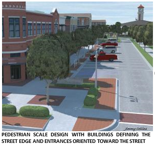
Policy 1.6.6.3 To enhance the pedestrian environment, buildings shall be oriented to visually define the street edge. Landscaping and street trees shall be utilized to define the street edge along open spaces.
Policy 1.6.6.4 Non-residential uses shall have minimal setbacks from a street right-of-way, so long as adequate space is provided for pedestrian facilities, amenities and street trees. Setbacks may be wider if a courtyard, plaza, public space or seating is provided between the building and the sidewalk. Outdoor seating is encouraged and allowed for non-residential uses. Setbacks and build-to lines shall be established for residential uses.
Policy 1.6.6.5 All single-family attached, multi-family and non-residential uses shall require architectural design review established in the Land Development Regulations (LDR’s) including:
(a) Flexibility in design shall allow for choice and variety in architectural style. Building facades shall provide variation in materials, roof lines, window patterns and reliefs. Objective, measurable criteria including size, scale, proportion, and materials shall be established.
(b) Large expanses of solid wall fronting a street are prohibited. Minimum percentages of transparent glass on the façade of buildings shall be established. All buildings shall articulate the line between the ground floor and upper levels.
Policy 1.6.6.6 Stormwater facilities shall be master planned. The location of surface stormwater facilities within the village center is discouraged. Surface stormwater facilities located in the village center should be designed in a park like manner serving as an amenity to the development. The use of Low Impact Design (LID) techniques is required in the Sensitive Karst Areas and encouraged Countywide.
Policy 1.6.6.7 Open Space provisions shall comply with all applicable Comprehensive Plan policies and land development regulations.
Policy 1.6.6.8 The preferred location of above ground utilities, except for life safety, is to the rear and side of buildings. Above ground utility access, transfer and conveyance points such as panels, boxes, meters, and valves shall be screened from the street and sidewalks through architectural features and/or landscaping. Underground utilities are encouraged to be compressed to minimize ROW width, allow adequate space for street trees and provide for the visual definition of the street.
Policy 1.6.6.9 All recycling and trash collection for non-residential, multi-family and single family attached uses shall be located to the rear of buildings or within parking facilities. Recycling and trash collection facilities shall be screened.
Policy 1.6.7 Transportation Network: The transportation network shall be designed as a continuous interconnected network of narrow streets, including a pedestrian and bicycle circulation system, designed to calm traffic speeds and encourage walking and bicycling throughout the development, provide connectivity, and functionally and physically integrate the various uses within and beyond the neighborhood to reduce the distances of travel between uses and promote the internal capture of trips, reduce impact on external roadways, and promote transit use.
Policy 1.6.7.1 The interconnected street network design shall be organic, block or radial.
Policy 1.6.7.2 The street network shall be designed to utilize smaller block lengths:
(a) Perimeter block lengths shall not exceed 1,300 linear feet within the village center, 1,600 linear feet within the transit supportive area outside of the village center, and 2,000 linear feet outside the transit supportive area.
(b) Perimeter blocks lengths with parking provided in the interior of the block shall not exceed 2,000 linear feet in the village center, 2,300 linear feet within the transit supportive area outside of the village center, and 2,700 linear feet outside the transit supportive area.
(c) Perimeter block lengths may be extended an additional 700 linear feet so long as parking is provided interior to the block, and a safe, convenient, landscaped pedestrian and bicycle path consistent with block lengths in (b) above is provided.
(d) In limited instances, for projects greater than 100 acres, perimeter block lengths may be extended up to 3,000 linear feet where a multi-level parking structure or single occupant retail use greater than 25,000 square feet are located, so long as parking is provided interior to the block, and a safe, convenient, landscaped pedestrian and bicycle path consistent with block lengths in (b) above is provided.
(e) The length of environmental, physical, topographic and property boundary constraints are allowed to be used to meet perimeter block length requirements.
Policy 1.6.7.3 Interconnectivity for vehicles, pedestrians and bicyclists shall be provided between uses. Access may be limited for independent / assisted living facilities in order to provide for the safety and security of residents.
Policy 1.6.7.4 Street design standards shall address narrow pavement and right-of-way widths, turning radii, on-street parking, and other design criteria for roads, alleys and lanes. Standards shall promote walking and biking, ensure pedestrian and bicyclists safety, and allow for emergency and transit access. Urban green streets and Low Impact Development (LID) techniques are allowed and encouraged.
Policy 1.6.7.5 Cross-access for vehicles, pedestrians and bicyclists shall be provided to adjacent developed and undeveloped land. Exceptions may be made for environmental, topographical, or physical constraints.
Policy 1.6.7.6 The street network shall include a pedestrian and bicycle circulation system that interconnects all uses, including parks, plaza, squares and open spaces.
Policy 1.6.7.7 The streetscape within village centers shall require street furniture, planters, location maps, signage, trash receptacles and lighting along streets. The streetscape shall be compatible with regards to sidewalk materials, streetlights, cross-walks, signage, benches, and pedestrian amenities.
Policy 1.6.7.8 Pedestrian facilities shall be provided on both sides of all streets within the right-of-way. The width of pedestrian facilities shall increase as densities and intensities increase. The widest pedestrian facilities shall be provided adjacent to non-residential and mixed-use buildings. Streets providing access to single-family detached units shall have the option of providing a multi-use path parallel to the streets in-lieu of sidewalks consistent with provisions in the Transportation Mobility Element.
Policy 1.6.7.9 One-way streets are allowed throughout the development as a means to reduce crossing distances and conflicts, impervious surfaces, and right-of way widths, thus allowing for further definition of the street edge and a sense of enclosure for pedestrians.
Policy 1.6.7.10 Street trees with adequate planting areas shall be provided along all streets.
Policy 1.6.7.11 For projects contiguous with a Rapid Transit Corridor, dedicated transit lane(s) for use by transit vehicles or fixed guide-way rail lines for streetcars or light rail shall be provided within or adjacent to the development consistent with the Rapid Transit Corridor Map. Multi-lane roadways in-lieu of dedicated lanes may be provided within the transit supportive area for developments that can demonstrate future transit headways of 10 minutes can be maintained and feature either block lengths that average 300 feet or less or include fixed guide-way rail lines. Regional Transit System (RTS) shall be a reviewing entity along with the County and FDOT along State roadways.
Policy 1.6.7.12 Projects contiguous with the portion of the Express Transit Corridor along Tower Road shall provide either site related turn out facilities (bus bays) or dedicated lane(s). Regional Transit System (RTS) shall be a reviewing entity along with the County and FDOT along State Roadways.
Policy 1.6.7.13 For projects contiguous with a Rapid Transit Corridor, a park and ride facility shall be provided within or adjacent to the development in close proximity to the transit station consistent with the Rapid Transit Corridor Map. Park and ride facilities shall be designed for shared evening and weekend use by the development. Park and rides shall be designed in accordance with block, street tree and pedestrian facility requirements of this Element and are encouraged to be screened by liner buildings. Regional Transit System (RTS) shall be a reviewing entity along with the County and FDOT along State roadways.
Policy 1.6.8 Parking: To promote a walkable, urban scale environment, off-street parking shall be significantly limited and designed in such a manner as to minimize visibility from the street. Parking areas shall be designed to minimize intrusiveness through the following techniques:
(a) Innovative solutions to reduce parking requirements, decoupling parking from residential uses, provision of shared parking to serve multiple uses and alternative paving materials are allowed. Parking maximums and innovative solutions to address parking shall be established in the Land Development Regulations. Reduced landscaped requirements may be allowed for off-street parking provided interior to blocks.
(b) On-street parking is allowed throughout the development. On-street parking is required on the majority of streets within the transit supportive area. Angled on-street parking shall be accessed via a drive aisle separated from through traffic by a landscaped median on roadways with a projected AADT greater than 5,000 trips.
(c) Off-street parking, except for ingress and egress, shall be located to the rear of buildings and shall be screened from streets and sidewalks, via liner buildings. Densely landscaped, pedestrian friendly squares and plazas may be allowed between liner buildings. A dense landscaped buffer with a multi-use pedestrian and bicycle facility may be utilized along one side of the off-street parking. Off-street parking adjacent to open space or an environmental, topographical, physical or property boundary constraint may be lined by either buildings or a dense landscaped buffer with a multi-use pedestrian and bicycle facility.
(d) Off-street parking shall clearly delineate routes for pedestrians and bicycles through parking areas to accommodate safe and convenient pedestrian and bicycle circulation between uses and create a park-once environment.
(e) Vehicular use areas, other than off-street parking, shall be located along the side and rear of a building. Limited exceptions may be allowed for loading areas within drive aisles provided as part of on-street parking separated from through traffic by a median.
(f) Single-family garages shall be located at the rear or side of the building. Exceptions shall be allowed to address environmental, topographical, physical or property boundary constraints.
(g) A single transitionary off-street parking area may be allowed. The perimeter block length shall not exceed the perimeter block length requirements in Policy 1.6.7.2. Sidewalks and street trees shall be provided along the entire perimeter block length. Plans shall be submitted demonstrating the liner buildings to be provided at a future date along with justification why the additional parking is needed and why it cannot be provided elsewhere.
(h) Single occupant retail uses greater than 25,000 square feet per floor may have parking in front of buildings so long as all surface parking and the side and rear of the building are screened from adjacent streets by liner buildings. The rear of the building for single occupant retail uses between 25,000 and 50,000 square feet per floor may front a street so long as a functional entrance is provided and the architecture of the building provides a pedestrian friendly environment and complies with all design requirements for buildings fronting a street.
Policy 1.6.9 Affordable Housing Incentives within Traditional Neighborhood Developments: : Affordable housing shall be encouraged and incentivized within Traditional Neighborhood Developments through the following strategies.
(a) Substitution of Non-Residential Floor Area with Affordable Residential Units
The minimum required amount of non-residential floor area within the TND may be substituted with affordable residential units in accordance with the following:
(1) The Land Development Regulations shall include detailed options for substituting non-residential floor area with affordable residential units within TNDs. Options shall include substitution rates that provide greater reduction in the required non-residential floor area per unit by providing greater depth of affordability. Options shall also include substitution rates that allow for and encourage the development of affordable residential units within unbuilt non-residential portions or phases of existing TNDs that are otherwise substantially built out.
(2) The total non-residential floor area within a TND shall not be reduced to an amount less than 10,000 square feet as a result of any substitution under this subsection.
(3) As a density bonus, affordable residential units proposed under this subsection shall not be counted toward the maximum allowable residential density within the development and they shall not be included in the calculation of the required non-residential floor area for the TND.
(b) Density Bonus for Provision of Affordable Residential Units
&A density bonus of up to 4 dwelling units per acre is allowable within a TND provided that a minimum of 20% of the additional units realized through this bonus are designated as affordable. Such bonus units shall not be included in the calculation of the required non-residential floor area for the TND.
(c) Affordability Standards
&For purposes of this policy, affordable residential units are residential units that are designated as affordable to households with income at or below 80% of the area median income (AMI) for households within the Metropolitan Statistical Area, adjusted for family size. Such units must remain affordable for a period of 30 years.
(d) General Standards for Affordable Residential Units
&Affordable residential units proposed under this policy must be provided on-site and should generally not be concentrated in one portion of the development. They must be comparable to market rate units within the development in terms of overall quality of construction, quality of exterior appearance, and energy efficiency, and must have the same access to all on-site amenities available to market rate units.
(e) Affordability requirements will be guaranteed by an agreement between the developer and the County as part of the development review process, as detailed in the Land Development Regulations. OBJECTIVE 1.7 - TRANSIT ORIENTED DEVELOPMENT To provide for compact, mixed-use, pedestrian and bicycle friendly communities designed with the densities and intensities needed to support transit service, reduced per capita greenhouse gas emissions and enable an individual to live, work, play and shop in a community without the need to rely on a motor vehicle for mobility. Policy 1.7.1 Transit Oriented Developments shall be: (a) Allowed in areas designated on the Future Land Use map for Urban Residential Densities (Policy 1.3.2.1) and Activity Centers within the Urban Cluster, (b) At least 15 acres in size, (c) Served by Express Transit Service and be contiguous to a Rapid Transit or Express Transit Corridor consistent with the Transportation Mobility Element. (d) Allowed through Development plan approval consistent with the Comprehensive Plan and Land Development Regulations. Policy 1.7.2 Public Participation. Public Participation shall be consistent with standards in Policy 1.6.2 . Policy 1.7.3 Transit Oriented Developments shall provide: (a) A village center with a transit station contiguous with a Rapid Transit or Express Transit corridor, (b) The necessary densities to support transit service, (c) Compact, mixed-use development to allow for the internal capture of pedestrian, bicycle and vehicular trips, (d) A pedestrian and bicycle friendly environment that encourages walking and bicycling as a primary means of mobility within the development, (e) A gridded street network that emanates from the village center that allows for multiple route choices, reduces the distance between uses to encourage walking and biking, and connects with adjacent developments, (f) Funding for express transit service consistent with the frequency and span of service specified within the Transportation Mobility Element, (g) On-street parking and screening of off-street surface parking. Policy 1.7.4 Village Center: Transit Oriented Developments shall be required to have a compact, definable mixed use, pedestrian and bicycle friendly village center that is served by transit and offers multiple destinations and reasons for pedestrians and bicyclist to frequent the area. The Village Center shall be consistent with the Policies 1.6.4.1 through1.6.4.7 of this element. Policy 1.7.5 Density & Mixed Uses: A balanced mixture of uses shall be provided to create activity throughout the day and allow individuals to live, work and play in the same community without having to rely solely on a motor vehicle for mobility, thereby allowing a reduction in per capita greenhouse gas emissions. Policy 1.7.5.1 To ensure the density needed to support transit service is provided within a walkable distance from transit, the following minimum residential densities shall be provided: (a) Ten (10) units per acre within the village center (b) Seven (7) units per acre within the transit supportive area outside of the village center (c) Three (3) units per acre outside the transit supportive area (d) Development less than 20 acres shall provide a minimum of at least 200 units Policy 1.7.5.2 The maximum allowable density within the transit supportive area is twenty-four (24) units per acre, except as provided for in Policy 1.3.10.4 of this element. The maximum allowable density within the Village Center is forty-eight (48) units per acre. The maximum allowable density outside the transit supportive area is the maximum allowable under the underlying land use. Policy 1.7.5.3 To ensure a mixture of uses, the following non-residential square footage (heated and cooled) his required: (a) Provide at least 10,000 square feet of non-residential uses, plus (b) A minimum of 100 square feet of non-residential uses for every 1 residential unit. (c) A maximum of 500 square feet of non-residential uses for every 1 residential unit shall be allowed. (d) To encourage infill and redevelopment, the square footage of existing non-residential may either be utilized to meet the requirements above or be in addition to the above requirements. Policy 1.7.5.4 For developments that are at least 100 acres in size, mini storage facilities principally designed to serve the project is allowed so long as specific design criteria are established to mask the facility, integrate the use with the surrounding development and comply with all required Transit Oriented Design criteria. The facility is not allowed within the village center and the square footage of the facility shall be excluded from the non-residential square footage in policy 1.7.5.3. Policy 1.7.5.5 Allowable uses, mixed use provisions and percentages and phasing shall be consistent with policies 1.6.5.3 through 1.6.5.14 of this element. Policy 1.7.6 Site and Building Design: Site and building design and scale shall be oriented towards creating a pedestrian, bicycle and transit friendly environment. Architectural and site design techniques shall be used to promote walkable, vibrant communities. Site and building design shall be consistent with policies 1.6.6 through 1.6.6.9 of this element. Policy 1.7.7 Transportation Network: The transportation network shall be designed as a continuous interconnected network of narrow streets, including a pedestrian and bicycle circulation system, designed to calm traffic speeds and encourage walking and bicycling throughout the development, provide connectivity, and functionally and physically integrate the various uses within and beyond the neighborhood to reduce the distances of travel between uses and promote the internal capture of trips, reduce impact on external roadways, and promote transit use. Transportation network design shall be consistent with policies 1.6.7 through 1.6.7.13 of this element. Policy 1.7.8 Parking: To promote a walkable urban scale environment, off-street parking shall be significantly limited and designed in such a manner as to minimize visibility from the street. Parking design shall be consistent with Policy 1.6.8 of this element and the following: Policy 1.7.8.1 For projects with more than 2,000 cumulative peak hour trips, 50% of all required parking shall be provided via parking structures and on-street parking. Policy 1.7.8.2 Non-residential uses shall be provided on the exterior of the 1st floor of any parking structure fronting a street, except for parking structures surrounded by liner buildings. Criteria shall be established for the exterior portions of parking structures not surrounded by liner buildings. Policy 1.7.9 Express Transit Service shall be provided from the development to the University of Florida consistent with Express Transit Corridors Map. The frequency and span of service required shall be consistent with the requirements of the Transportation Mobility Element. The Express Transit Service shall be funded for a fifteen (15) year period. Standards shall be established in the Land Development Regulations (LDRs) to ensure the level of funding is provided on a proportional basis. The employees, employers and residents of the development that contribute towards the Express Transit Service shall be provided with a mechanism that ensures they ride fare free so long as the development funds transit. The funding mechanism, details, and cost to provide Express Transit Service shall be memorialized in an enforceable developer agreement between the developer and the County in consultation with the Regional Transit System. Annexation into a municipality shall not absolve the developments requirement to fund express transit service. Policy 1.7.10 Dedicated transit lane(s), transit turnouts (bus bays) and park and ride facilities shall be provided consistent with policies 1.6.7.11 through 1.6.7.13 of this element. Policy 1.7.11 Affordable Housing Incentives within Transit Oriented Developments: : Affordable housing shall be encouraged and incentivized within Transit Oriented Developments through the following strategies. (a) Substitution of Non-Residential Floor Area with Affordable Residential Units
The minimum required amount of non-residential floor area within the TOD may be substituted with affordable residential units in accordance with the following:
(1) The Land Development Regulations shall include detailed options for substituting non-residential floor area with affordable residential units within TODs. Options shall include substitution rates that provide greater reduction in the required non-residential floor area per unit by providing greater depth of affordability. Options shall also include substitution rates that allow for and encourage the development of affordable residential units within unbuilt non-residential portions or phases of existing TODs that are otherwise substantially built out.
(2) The total non-residential floor area within a TOD shall not be reduced to an amount less than 10,000 square feet plus 50 square feet per total residential unit as a result of any substitution under this subsection.
(3) As a density bonus, the affordable residential units proposed under this policy shall not be counted toward the maximum allowable residential density within the development and they shall not be included in the calculation of the required non-residential floor area for the TOD.
(b) Density Bonus for Provision of Affordable Residential Units
A density bonus of up to 4 dwelling units per acre is allowable within a TOD provided that a minimum of 20% of the additional units realized through this bonus are designated as affordable. Such bonus units shall not be included in the calculation of the required non-residential floor area for the TOD.
(c) Affordability Standards
For purposes of this policy, affordable residential units are residential units that are designated as affordable to households with income at or below 80% of the area median income (AMI) for households within the Metropolitan Statistical Area, adjusted for family size. Such units must remain affordable for a period of 30 years.
(d) General Standards for Affordable Residential Units
Affordable residential units proposed under this policy must be provided on-site and should generally not be concentrated in one portion of the development. They must be comparable to market rate units within the development in terms of overall quality of construction, quality of exterior appearance, and energy efficiency, and must have the same access to all on-site amenities available to market rate units.
(e) Affordability requirements will be guaranteed by an agreement between the developer and the County as part of the development review process, as detailed in the Land Development Regulations. OBJECTIVE 1.8 COTTAGE NEIGHBORHOODS Cottage Neighborhoods offer opportunities for creative, diverse and high quality infill development within the Urban Cluster and promote a variety of housing types and sizes available within the community to meet the needs of a population diverse in age, income, and household composition. These neighborhoods provide for more efficient use of land through density bonuses consistent with Housing Element Policy 1.2.2, which provides incentives for development of affordable housing. Cottage Neighborhoods encourage the creation of more usable open space for residents of the development and maximize resident and pedestrian oriented outdoor spaces while minimizing the impact of automobile traffic and parking. Policy 1.8.1 Cottage Neighborhoods are groups of smaller homes built around a common green space. Policy 1.8.2 Design criteria for Cottage Neighborhoods shall be established in the Unified Land Development Code and shall include, but not be limited to, provisions for clustering, and maximum neighborhood size. Policy 1.8.3 Cottage Neighborhoods meeting the design requirements for such neighborhoods in the Unified Land Development Code shall be allowed to develop at two times the maximum units per acre of the zoning district designation. OBJECTIVE 1.9 CELEBRATION POINTE TRANSIT ORIENTED DEVELOPMENT To provide for a compact, mixed-use, interconnected development that creates a pedestrian, bicycle and transit friendly environment through site and building design with the densities and intensities of land uses needed to enable a person to live, work, play and shop within a development that provides mobility and accessibility options and that preserves natural areas adjacent to environmentally sensitive lands. Policy 1.9.1 The northwest quadrant of 1-75 and Archer Road designated as Mixed-use on the Future Land Use Map shall be known as the Celebration Pointe Transit Oriented Development and shall be developed as Transit Oriented Development consistent with policies under Future Land Use Element Objective 1.7 except as otherwise provided herein under Objective 1.9. Celebration Pointe TOD shall be: (a) Allowed 2,000 dwelling units and 1.5 million square feet of nonresidential uses. Upon entering into an agreement with the County that guarantees 10% of additional units over 2,000 are affordable to households earning up to 50% of the Area Median Income, an additional 500 units may be approved. Additional units over 2,000 will require a reduction of 750 sq. ft. of non-residential per dwelling unit. The maximum number of permitted units shall not exceed 2,500. Notwithstanding Policy 1.9.2(c), additional development beyond 2,000 units may be located anywhere within the development.
(b) Allowed to incorporate existing non-residential buildings and dwelling units into the development. Existing buildings, dwelling units and parking areas are not required to meet design elements of Objective 1.9 until they are redeveloped or enlarged. (c) Allowed to repurpose surface and structured parking areas throughout the development for infill and expansion of existing buildings up to the approved development entitlements. (d) Allowed to propose alternative design concepts where the applicant can demonstrate that deviation is necessary and will result in a better development outcome while maintaining consistency with the intent provided in the Comprehensive Plan and subject to ULDC regulations for alternative compliance in TNDs and TODs. (e) Allowed to amend the existing approved Preliminary Development Plan to be consistent with Objective 1.9 and be permitted, if desired by the Developer and approved by the County, to establish specific conditions, criteria and standards on a Preliminary Development Plan that are consistent with Objective 1.9. (f) Consistent with Unified Land Development Code (ULDC) policies for Transit Oriented Development, expect as otherwise provided for under Objective 1. 9 of the Future Land Use Element or through conditions, criteria and standards on an approved Preliminary Development Plan that are consistent with Objective 1.9.
(g) Allowed a multisport and entertainment events center. The events center shall be considered a civic use and shall not have a maximum building footprint size. The multisport floor area and ancillary facilities such as locker rooms, offices and restrooms shall not be calculated toward the total non-residential square footage allowance for the development. The events center shall be located within the village center and the front of the center
shall be screened along the pedestrian promenade by buildings with various permitted uses, except for the venue entrance. Public pedestrian entrances are not required along the sides and rear of the events center. Non-commercial wall murals may substitute for otherwise required glazing or architectural articulation and material change requirements. Off-street areas for service delivery and pick-up, drop-off and loading zones shall be exempted from shading requirements.
Policy 1.9.2 Celebration Pointe TOD shall provide: (a) A compact and centrally located village center (VC) oriented and designed around a main street and / or pedestrian promenade. (b) A transit supportive area (TSA) outside the village center. The extents of the VC, TSA and areas outside the TSA shall be shown on the Preliminary and Final Development Plan. (c) The highest concentration of residential dwelling units (DU) shall be within the VC and TSA. The following are the minimum and maximum DU required and allowed within the VC, TSA and outside the TSA: (1) A minimum of 500 DU and a maximum of 1,000 DU in the VC. (2) A minimum of 300 DU and a maximum of 600 DU in the TSA. (3) A minimum of 200 DU and a maximum of 400 DU outside the TSA. (d) The highest concentration of non-residential land uses shall be within the VC. The following are the minimum and maximum percentages of non-residential square footage (NRSF) required and allowed with the VC, TSA and outside the TSA: (1) A minimum of 50% NRSF and a maximum of 90% NRSF in the VC. (2) A minimum of 10% NRSF and a maximum of 50% NRSF in the TSA. (3) A minimum of 0% NRSF and a maximum of 10% NRS outside the TSA. (e) A vertical orientation and mixture of uses by requiring that a minimum of 25% of the allowed non-residential square footage shall be within multistory buildings. (f) Densities of residential uses and intensity of non-residential uses that encourages walking, bicycling, micromobility devices, low speed electric vehicles such as golf-carts, trolleys, autonomous transit shuttles and short vehicular trips. (g) A network of streets that provides interconnectivity, mobility and accessibility achieved through establishment of the following maximum perimeter block lengths: (1) A maximum of 2,000 linear feet in the VC. (2) A maximum of 2,300 linear feet in the TSA. (3) A maximum of 2,700 linear feet outside the TSA. (4) The maximum perimeter block length maybe extended an additional 700 linear feet where a multiuse path forms an internal block length consistent with the perimeter block lengths in Policy 1.9.2 (g) 1. 2. 3. (5) A maximum of 3,000 linear feet for blocks with a parking garage or single-use retail building 25,000 square feet of greater in size. (h) A centrally located multimodal center that allows for bike, micromobility, and car share programs, a park and ride, drop-off and loading areas for ride share programs, transit and autonomous transit, charging stations for electric vehicles, bikes and personal e-transport, and structured parking to promote a park-once environment. (i) For the continued maintenance, per the Conservation Management Area Management Plan, of 88.23 acres of environmentally sensitive land protected through a conservation easement approved on May 27th, 2014 and recorded on June 16th, 2014. Policy 1.9.3 Site, Building, Parking, and Street Design Site, building, parking and street design shall be oriented towards creating a multimodal supportive development that encourages walking, biking, transit, shared mobility and a park once environment. (a) The site, building, parking and street design shall create an environment that promotes walking and bicycling as a primary means of mobility. There shall be limited distances between attractors and generators and a mixture of land uses. Visual interest shall be provided through site and building design and orientation. (b) Building design and placement shall be at a pedestrian scale with primary entrances located at the front of the building oriented towards a public space such as a street, park, plaza, woonerf, open space or square. Outdoor seating is encouraged and allowed for all land uses. Shade shall be provided for pedestrians through means such as terraces, balconies, awnings, architectural features, buildings and trees. (c) Buffers within the development and along external boundaries are only required when adjacent to external single family detached dwellings on individual lots, or as required for outdoor storage. Arterial and collector road buffers for SW 45th St., SW 43rd St. and SW 32nd Rd. are not required. (d) To the extent feasible, utilities, except for life safety, shall be located to the rear and side of buildings. Underground utilities are encouraged. Above ground utility access, transfer and conveyance points such as panels, boxes, meters, and valves shall be screened from the street and sidewalks through architectural features and/or landscaping. (e) Innovative solutions to reduce parking requirements, decoupling parking from residential uses, provision of shared parking to serve multiple uses and alternative paving materials are allowed. No off-street surface parking is required for any use. Off-street parking may be shared and pooled between uses throughout the development. (f) Parking structures may be located throughout the development, except immediately adjacent to conservation areas and the village center main street/pedestrian promenade. Parking structures shall make provisions for liner buildings, bottom floor uses or landscaping when fronting a street. (g) Off-street surface parking areas shall be located to the rear of buildings in the VC and TSA. Parking areas along the external property boundaries of the Celebration Pointe TOD are not required to be screened by buildings at the property boundary. Outside the TSA, off-street surface parking areas are permitted around all sides of buildings and are not required to be screened by liner buildings or pocket parks. (h) Liner buildings are encouraged but are not required for off-street parking. If liner buildings are not proposed, landscaping shall be provided to screen the parking consistent with ULDC requirements for landscaping off-street parking in TODs. (i) Temporary off-street surface parking areas may be permitted throughout the development to allow for construction of parking structures. The time frame for temporary parking areas shall be included on a Preliminary Development Plan. (j) Travel lanes may be ten feet in width on public roads within the development that also include on-street bike lanes. Travel lanes on private roads may be as narrow as nine feet in width or fourteen feet in total width for living streets and alleys. Traffic calming, raised intersections, curb extensions, along with other appropriate techniques are permitted along private roads within the development. (k) In order to promote walkability and safe multiple modes of travel, speed limits may be posted as low as permissible under state statute, for public roads, or as low as can be demonstrated safe for private roads. (l) The use of golf carts and low-speed electric vehicles are permitted on all designated streets within the development. The use of golf carts and low-speed electric vehicles on Celebration Pointe Avenue over Interstate 75 and on SW 45th Street, south of the entrance to the Reserve at Kanapaha shall only be allowed if permitted by the County Engineer. The use of golf carts and low-speed electric vehicles on designated off-street facilities may be allowed subject to approval by the County Engineer. (m) A circulator system that provides access to the transit transfer station east of Interstate 75 shall be permitted on all roads within the development and may address the development’s requirements to provide transit service, if included in a developer agreement approved by Alachua County. The circulator may utilize dedicated transit lanes if approved by the County Engineer. (n) To provide the highest level of pedestrian and bicycle accommodation, land uses with drive-thru facilities are prohibited in the VC. In recognition of greater levels of vehicular traffic on SW 45th Street and Celebration Pointe Avenue, land uses with drive-thru facilities in the TSA are allowed so long as the drive-thru facilities are located to the rear of the building and screened from adjacent streets. In recognition of existing commercial and tourist entertainment land uses oriented to serve demand from Interstate 75 and Archer Road, drive-thru facilities outside the TSA are permitted and shall be developed consistent with the general standards of the land development regulations applicable to all districts where said use is permitted. Where drive-thru facilities cross a pedestrian facility, appropriate marking and /or materials shall be provided to provide for safe pedestrian crossing. (o) To provide the highest level of pedestrian and bicycle accommodation, land uses for the dispensing of fuel, cleaning or servicing of vehicles are prohibited in the VC and TSA. In recognition of existing commercial and tourist entertainment land uses oriented to serve demand from Interstate 75 and Archer Road, land uses for the dispensing of fuel, cleaning or servicing of vehicles are allowed outside the TSA are permitted and shall be developed consistent with the general standards of the land use development regulations applicable to all districts where said use is permitted. (p) Mini-storage land uses are prohibited within the VC. Mini-storage uses are permitted within the TSA and outside the TSA so long as they are located along the periphery. The square footage of mini-storage units shall be excluded from allowable non-residential development. (q) Outdoor storage of boats, recreational vehicles, golf carts, jet skis, trailers and all-terrain vehicles may be provided for residents of the development for non-commercial purposes along the periphery of the TSA and outside the TSA. Outdoor storage shall be enclosed by a 10’ tall masonry wall and a medium density landscape buffer. Policy 1.9.4 Landscaping A tree mitigation phasing shall be provided, subject to County approval, to phase the planting of trees within blocks and stormwater management areas concurrent with development of adjacent buildings. Trees required for public roads shall be planted prior to acceptance of the roads by the County and warrantied per the same requirements as established for the roads. 2.0 URBAN ACTIVITY CENTER POLICIES OBJECTIVE 2.1 – GENERAL Promote efficient use of land through designation of Activity Centers within the Urban Cluster which provide for nodes of higher density and intensity mixed uses that are interconnected with other commercial, employment, light industrial, and institutional centers within Alachua County through a system of multimodal corridors and a public transit system. Urban design standards for Activity Centers will provide for compact, mixed use, and pedestrian-friendly development, which is functionally integrated with surrounding land uses. Policy 2.1.1 Activity Centers are identified and designated on the Future Land Use Map. Policy 2.1.2 Activity Centers shall be designated based on two classifications depending on the size, location and function of the Activity Center: (a) High intensity activity centers are intended for commercial, employment, institutional, light industrial, and visitor-related uses of a scale and type that typically serve a regional or larger market. High activity centers shall also contain higher density residential uses which are phased and interconnected with the non-residential uses in the Activity Center. High intensity activity centers attract commercial customers or employees from within Alachua County and surrounding cities or counties; are generally greater than 200 total acres in area; are located proximate to major interstate transportation corridors; have access to at least two arterial roadways; and are near existing or planned rapid transit corridors. (b) Low intensity activity centers are intended for commercial, employment, institutional, and light industrial uses of a scale and type that typically serve a community or group of neighborhoods. Low activity centers shall also contain residential uses which are phased and interconnected with the non-residential uses in the Activity Center. Low intensity activity centers attract commercial customers or employees primarily from within Alachua County; are generally less than 200 total acres in area; have access to at least one arterial and one collector roadway, and are near existing or planned bus, express transit, or rapid transit routes. (c) Detailed standards shall be included in the Land Development Code which distinguish between Low intensity and High intensity activity centers in terms of the type and scale of allowable land uses, requirements for mixed uses, and development design requirements. Policy 2.1.3 New development and redevelopment within Activity Centers shall be consistent with the design standards of Policies 2.1.4 through 2.1.12. Policy 2.1.4 A mixture of residential and non-residential land uses shall be provided in Activity Centers to reduce travel distances between different types of land uses and support pedestrian, bicycle and transit opportunities. (a) Mixed use development plans, including vertical and horizontal mixed uses, shall be allowable in all areas within Activity Centers. (b) In order to increase the variety of housing opportunities within walking distance of existing or future commercial and employment areas, residential uses shall be allowable as part of mixed use development in non-residential Future Land Use designations, in accordance with the following: (1) Ratios of residential dwelling units to non-residential floor area shall be specified in the Land Development Code for mixed use development in accordance with this policy. The mixed use ratios will allow for existing commercial, office, or institutional uses within one-quarter mile of proposed residential development to be used in calculating the allowable number of residential units. (2) Residential uses in mixed use development in accordance with this policy shall be physically and functionally integrated with existing or proposed non-residential uses. (c) Within residential Future Land Use designations in Activity Centers, commercial, office, or institutional uses shall be allowable as part of mixed use developments, Traditional Neighborhood Developments, or Transit Oriented Developments. (d) Development projects which exceed minimum size thresholds shall be required to provide a mix of residential and non-residential uses. Minimum thresholds for acreage and non-residential floor area shall be established in the Land Development Code. Policy 2.1.5 Development within Activity Centers shall be designed to produce compact, pedestrian-oriented, mixed use development which is integrated within the surrounding community. Architectural and site design techniques shall be used to define pedestrian and public space and to provide human scale with the Activity Center. At a minimum, Activity Center sites and buildings shall achieve the following: (a) Land uses shall be organized around centralized public civic spaces, with pedestrian and bicycle routes connecting civic spaces to development within and surrounding the Activity Center. (b) Development shall be organized along a density and intensity gradient that takes into account surrounding land uses and existing and planned multimodal transportation corridors. The highest density and intensity development shall be located within walking distance of public civic spaces and existing or planned transit facilities. (c) Activity Centers shall be organized into an interconnected network of streets and blocks which minimizes walking distance between buildings and land uses. A range of average block perimeters shall be specified in the Land Development Code which take into account the level of the Activity Center, proposed land uses, and the availability of existing or planned transit service. Average block perimeters shall generally be smaller in areas located within walking distance of existing or planned transit service. Larger blocks shall be required to provide mid-block pedestrian connections. (d) Primary public entrances to buildings shall front adjacent public streets with sidewalks or a civic space; primary public entrances to buildings shall also be connected with the surrounding public sidewalk network. (e) Buildings shall be oriented to define the street edge in developed areas. Landscaping and street trees shall be used to define the street edge in open space areas. (f) Vistas created by street terminations within the Activity Center shall incorporate significant buildings or places to the maximum extent possible. (g) Shaded areas and protection from the elements for pedestrians shall be provided as part of the streetscape within developed areas. (h) Building facades shall provide variation in materials, roof lines, window patterns and reliefs. Multiple-story buildings shall articulate the division between the ground floor and upper floors. Minimum percentages of transparent glass on the facade of buildings shall be established in the Land Development Code. (i) A series of smaller, well defined customer entrances shall be used to break up long facades and provide pedestrian scale and variety. This may be achieved through the use of liner buildings. (j) Maximum building setbacks or build-to lines shall be established in the Land Development Code which allow sufficient space for pedestrian facilities and amenities, street trees, and utilities. Setbacks may be wider where a courtyard, plaza, public space or seating is provided as part of the streetscape in developed areas. Policy 2.1.6 Activity Centers shall include a multimodal street network which provides interconnectivity of land uses within and surrounding the Activity Center. (a) Activity Centers shall be organized into an interconnected network of streets and blocks in accordance with Policy 2.1.5.c. (b) The internal street network shall include a pedestrian and bicycle circulation system that interconnects all land uses, including residential, non-residential, parks, plazas, squares, and open spaces. Primary pedestrian and bicycle paths shall avoid routes through parking, loading, and delivery areas. (c) Points of individual driveway ingress to and egress from the Activity Center to the arterial and collector road (d) The street system shall provide multiple automobile, bicycle, and pedestrian linkages from the Activity Center to surrounding development as an alternative to arterial and collector road (e) Automobile-oriented uses shall have a limited number of driveways, and drive-in or drive-up windows shall be located to minimize conflict with pedestrian and bicycle traffic. (f) Pedestrian facilities shall be provided on both sides of all streets within the right-of-way. Streets providing access to single-family detached units may provide a multi-use path parallel to the street as an alternative to sidewalks, consistent with the Transportation Mobility Element. (g) Street furniture, planters, trash receptacles and lighting shall be provided as part of the streetscape in non-residential and mixed use areas. (h) One-way streets shall be allowable as a means to reduce crossing distances and conflicts, impervious surfaces, and right-of way widths. (i) Developments contiguous to an Express Transit Corridor as provided on the Express Transit Corridors Map shall provide either site related turn out facilities (bus bays) consistent with stop spacing standards, or dedicated lane(s) as part of the development plan. (j) Developments contiguous to a Rapid Transit Corridor as provided on the Rapid Transit Corridors Map shall dedicate the necessary right-of-way proportionate to the impacts of the development. Transit Oriented Developments and Traditional Neighborhood Developments shall provide dedicated facilities consistent with Future Land Use Element Policy1.6.7.11. (k) Street design standards shall be provided in the Land Development Code and shall address narrow pavement and right-of-way widths, turning radii, on-street parking, other design criteria for roads, alleys and lanes, and Low Impact Design (LID) techniques for urban green streets. Standards shall promote walking and biking, ensure pedestrian and bicyclist safety, and allow for emergency and transit access. Policy 2.1.7 Parking areas shall be designed to minimize intrusiveness and impacts on pedestrian circulation and accessibility to development through the following techniques: (a) On-street parking shall be included in developments in order to provide traffic calming and produce a comfortable and safe pedestrian environment. (b) Structured parking shall be encouraged in all Activity Centers in order to promote the efficient use of land and a compact development pattern. (c) Large expanses of contiguous off-street parking areas which discourage pedestrian access to development shall be prohibited. Where off-street surface parking lots are included in a development, the preferred location shall be interior to blocks or to the rear of buildings, with a limited number of access points from the adjacent street. Off-street surface parking lots may be located on the interior side of buildings, subject to limitations and design criteria to be specified in the Land Development Code. Off-street surface parking lots shall generally not be located between buildings and adjacent pedestrian areas such as storefront streets and public squares. (d) Off-street surface parking lots shall be screened from streets, sidewalks, and open spaces. (e) Parking lots or structures shall be designed with safe and convenient pedestrian connections to business and residential entrances and public space to create a park-once environment. Policy 2.1.8 Stormwater management facilities shall be sufficient to serve the functional purpose, and shall be designed as a public amenity that provides usable open space or an aesthetic feature that resembles natural areas. The use of shared stormwater facilities shall be evaluated as part of the development plan process, and utilized to the extent feasible. Low Impact Design (LID) techniques for stormwater management are required in the Sensitive Karst Areas and encouraged Countywide. Policy 2.1.9 Development plans which are consistent with Comprehensive Plan Objective 2.1 and Policies 2.1.1 through 2.1.8, and are consistent with other provisions of the Comprehensive Plan, and the Land Development Code standards for Activity Centers described in this policy, shall be allowable through the development plan review process, notwithstanding conflicting provisions in the specific activity center plans contained in Policies 2.5.1 through 2.5.9 of this Element. Policy 2.1.10 The County shall initiate master plans for Activity Centers where necessary to promote redevelopment in accordance with Objective 2.1 and Policies 2.1.1 through 2.1.8. An Activity Center master plan shall include a generalized site plan for the entire Activity Center with related policies and standards to address allowable land uses, site and building design, transportation circulation and connectivity, parking, natural resource protection, public civic space, stormwater management facilities, and specific redevelopment considerations. Activity Center master plans shall include a public participation process incorporating neighborhood meetings or charrettes, notice to property owners, and other components. The County shall explore potential opportunities for public/private partnerships in developing Activity Center master plans. Master plans for Activity Centers shall include the following components: (a) A range of permitted land uses, residential densities, and non-residential intensity standards. (b) Dimensional standards for building height, scale, and orientation relative to adjacent streets. (c) Parking standards which establish maximum limits on parking for various land uses, and include opportunities for shared parking arrangements where adjacent land uses within a mixed use area have different peak usage hours. (d) Identification of conservation areas to be protected in accordance with the Conservation and Open Space Element. (e) Identification of the location and function of roads, bicycle routes, pedestrian routes, and transit facilities within the development site, and interconnections of these transportation facilities with the surrounding existing and planned transportation network. (f) Provision of a range of housing types and sizes to provide for affordable housing. Policy 2.1.11 Transit Oriented Developments meeting the requirements of Section 1.7 of the Future Land Use Element and Traditional Neighborhood Developments meeting the requirements of Section 1.6 of the Future Land Use Element are allowed within Activity Centers, notwithstanding any conflicting provisions in Policies 2.1.1 through 2.1.10 of this Element. Any Transit Oriented Development or Traditional Neighborhood Development shall be consistent with natural resource protection policies adopted as part of specific Activity Center Plans in Section 2.2 of the Future Land Use Element or in other elements of the Comprehensive Plan. Policy 2.1.12 New activity centers and expansion of the boundaries of existing activity centers shall require a Comprehensive Plan Amendment to establish the Activity Center boundaries and level in the Comprehensive Plan. Such Comprehensive Plan Amendments shall be considered based on the following: (a) Location of new activity centers shall generally be near intersections of multi-modal corridors, and sites shall be adequately sized to allow development of a mix of non-residential and residential land uses, while providing for integration and interconnectivity with existing and future neighborhoods. (b) Availability and capacity of urban services and infrastructure including multimodal transportation, recreation, potable water and sanitary sewer, public schools, solid waste disposal, stormwater management, and public safety. OBJECTIVE 2.2 – ACTIVITY CENTER PLANS Development occurring within designated Activity Centers shall be consistent with the applicable policies and standards contained in this section and with Policies 2.1.4 - 2.1.12. Policy 2.2.1 Activity Center Plan – Springhills (a) Land Use (1) Commercial mixed uses should be limited to the areas designated on the Activity Center Plan Map and shopping center should be developed in accordance with the standards of Sections 3.5, 3.6. and 3.7. of the Future Land Use Element. Tourist and entertainment areas shown on the Plan map should be restricted to retail commercial activities associated with a transient clientele. Limited retail and service commercial uses should be permitted in warehouse and distribution areas and in office areas where such retail uses are clearly accessory to and related to the principal uses or where the retail uses are provided to serve the businesses and employees within the development. Such retail uses shall be located internal to the development with no exposure outside the development being served. Floor area ratios (FAR) for office, warehouse/distribution and commercial uses shall not exceed 1.0 except as otherwise established herein. a. The Springhills Activity Center shall be designated a High Activity Center/Retail which shall have commercial activities as its primary use and office, residential, warehouse/distribution, light industrial as secondary uses providing they are compatible with primary uses. The scale of these secondary activities may be at a regional level of 300,000 - 1,000,000 sq. ft. gross leasable area or more. The scale of these activities may be at a regional level of 300,000 - 1,000,000 sq. ft. gross leasable area or more. b. No regional mall shopping center, defined as a regional center with 300,000 - 1,000,000 square feet or more of retail usually enclosed (but not always) with an inward orientation of the stores connected by a common walkway with parking surrounding the outside perimeters, shall be permitted within this Activity Center. Rather, equivalent concentrations of a mix of commercial, office, residential, warehouse/distribution, and institutional activities shall be permitted. Source: International Council of Shopping Centers. (2) Parcel number 06041-003-000 shall permit a medical campus including “HM” type uses. Development within the area (SantaFe Village) designated ‘Mixed Use’ in the northeast quadrant of the Activity Center (Tax Parcel Numbers 06041-002-002, 06041-002-003, 06041-002-005) shall be a Transit Oriented Development providing a compact, mixed-use (both horizontally and vertically), pedestrian and bicycle friendly community designed with the densities and intensities needed to support transit service, reduce per capita greenhouse gas emissions enabling individuals to live, work, play and shop without the need to rely on a motor vehicle as the only means of mobility. Development shall be allowed through Development Plan approval. Development Plan approval shall adhere to the following standards: a. General Requirements: The SantaFe Village Transit Oriented Development shall include: 1. A village center and transit supportive area with the necessary densities to support transit services; and 2. Compact, horizontal and vertical mixed-use development to allow for the internal capture of pedestrian, bicycle and vehicular trips; and 3. A pedestrian and bicycle friendly environment that encourages walking and bicycling as a primary means of mobility within the development, 4. A gridded street network that emanates from the village center that allows for multiple route choices, reduces the distance between uses to encourage walking and biking, and connects with adjacent developments, 5. Funding for express transit service as provided in the Capital Improvements Element, 6. On-street parking and screening of off-street surface parking. b. Village Center and Transit Supportive Area: The SantaFe Village Transit Oriented Development shall include: 1. One or more village centers with: i. a transit station(s) that is safe, comfortable and convenient for its intended users, in close proximity to retail uses and of sufficient size to accommodate persons expected to live, work and shop within the development; and ii. a compact, definable vertical and horizontal mixed use, pedestrian and bicycle friendly area served by transit; and iii. multiple destinations and reasons for pedestrians and bicyclist to frequent the area; and iv. community gathering spaces, such as plazas, squares and open spaces designed to attract pedestrians and bicyclists and serve as the focal point of the development, appropriately sized to maintain urban character, pedestrian scale and proportional with the typical block length within the village center; and v. one or more central point(s) located in a plaza, square, open space or denoted by an architecturally significant feature from which policies related to the measurements of the village center(s) and the transit supportive area(s) are derived; and vi. an area or areas generally limited to 1/8 mile radius in size utilizing a block or radial pattern, measured from the central point; and vii. a primary orientation that is internal to the development; and viii. a minimum residential density of (10) units per acres; and ix. a maximum density of (24) units per acres; and x. a minimum of fifty (50) percent of the non-residential uses authorized for the entire Santa Fe Village Transit Oriented Development. 2. A transit supportive area, located outside the village center or village centers and within ¼ mile of the central point from which policies related to the measurements of village centers and transit supportive areas are derived, that: i. has a minimum of seven (7) units per acres; and ii. has a maximum density of (24) units per acres; and 3. A minimum of 10,000 square feet of non-residential use, plus a minimum of 100 square feet and maximum of 400 square feet of non-residential uses for each residential unit within the combined areas of the village center(s) and transit supportive area(s). To encourage infill and redevelopment, the square footage of existing non-residential within the site may either be utilized to meet the minimum non-residential requirement or added to the maximum allowed non-residential square footage. 4. A minimum of 20% of the non-residential use within the combined areas of the village center(s) and transit supportive area(s) shall be commercial retail. 5. A minimum of 20% of the non-residential use within the combined areas of the village center(s) and transit supportive area(s) shall be within vertically mixed structures. 6. To provide for a mixture of non-residential uses at a pedestrian friendly scale, no more than 70% of any block frontage shall be occupied by a single non-residential occupancy. 7. Non-residential uses shall be phased with the residential component of the development during the Development Plan review process requiring that not less than 50% of each such allowed uses, excluding civic uses, are constructed within each phase before subsequent phases may be approved. 8. Single occupant retail uses 50,000 square feet or greater shall provide: i. Separate liner buildings oriented towards a street on at least three (3) sides of the use with the rear of the building either fronting parking or lined by buildings, or ii. Contain a vertical mixture of uses with at least one (1) story above the ground floor, or iii. Multiple floors with a maximum of 50,000 square feet per floor, or iv. Provide parking on top of the building. c. The Santa Fe Village Transit Oriented Development may include: 1. A mixture of residential, commercial retail, office, financial, institutional, lodging, medical, research and development, clean/green technology, religious and civic uses anywhere within the site. 2. A range of housing options to provide opportunities for a variety of residents of various ages and income levels to reside within the same community. Single-family detached, single-family attached, multi-family, assisted and independent living facilities are all allowable residential uses. The number of rooms for lodging or hotel uses may be counted as residential units for the purposes of calculating non-residential square footage allowances. Assisted and independent living facilities may be counted either toward residential or non-residential square footage allowances. 3. Mixed uses, both horizontal and vertical, shall be allowed and are encouraged within all buildings at any location within the site. 4. The square footage of civic uses such as places of worship, libraries, schools and live-work studios may be excluded from the calculation of the maximum non-residential requirement provided that these uses are functionally integrated into the development, are located within the transit supportive area, and allow for shared parking during hours of non use. d. The SantaFe Village Transit Oriented Development shall adhere to the following site design requirements: 1. Site and building design and scale shall be oriented towards creating a pedestrian, bicycle and transit friendly environment. Architectural and site design techniques shall be used to promote walkable and bikeable communities. 2. The site layout and orientation of buildings shall create a development that is designed around the pedestrian and bicyclist and creates an environment that promotes walking and bicycling as a primary means of mobility. The following are the primary components of creating a pedestrian and bicycle friendly environment: i. An interconnected network of pedestrian and bicycle facilities, ii. Shade and protection from the elements, iii. Limited distances between attractors and generators, iv. Vertical and horizontal mixture of uses, and v. Visual interest through site and building design and orientation. 3. Building design and placement shall be at a pedestrian scale with primary entrances located at the front of the building oriented towards a public space such as a street, park, plaza or square. Shade shall be provided for pedestrians through means such as covered walkways, terraces, balconies, awnings and street trees. Limited exceptions may be allowed for residential and lodging uses that have a portion of units fronting a parking area located interior to a block. 4. Buildings shall be oriented to visually define the street edge. Landscaping and street trees shall be utilized to define the street edge along open spaces. 5. Non-residential uses shall have minimal setbacks from a street right-of-way, so long as adequate space is provided for pedestrian facilities, amenities and street trees. Setbacks may be wider if a courtyard, plaza, public space or seating is provided between the building and the sidewalk. Outdoor seating is encouraged and allowed for non-residential uses. 6. All residential and non-residential uses shall require architectural design review once standards and procedures for such review are established in the Land Development Regulations (LDR’s) providing for: i. Flexibility in design, allowing for choice and variety in architectural style, building facades with variation in materials, roof lines, window patterns and reliefs. ii. Objective, measurable criteria including size, scale, proportion, and materials. iii. A prohibition of large expanses of solid wall fronting a street. iv. Minimum percentages of transparent glass on the façade of buildings. v. The preferred location of above ground utilities, except for life safety, to the rear and side of buildings with above ground utility access, transfer and conveyance points such as panels, boxes, meters, and valves screened from the street and sidewalks through architectural features and/or landscaping. vi. Placement of all recycling and trash collection for non-residential, multi-family and single family attached uses, screened and placed at the rear of buildings or within parking facilities. 7. Underground utilities are encouraged to be compressed to minimize ROW width, allow adequate space for street trees and provide for the visual definition of the street. e. Transportation: The SantaFe Village Transit Oriented Development shall adhere to the following transportation design requirements: 1. The transportation network shall be designed as a continuous interconnected network of narrow streets, including a pedestrian and bicycle circulation system, designed to calm traffic speeds and encourage walking and bicycling throughout the development, provide connectivity, and functionally and physically integrate the various uses within and beyond the neighborhood to reduce the distances of travel between uses and promote the internal capture of trips, reduce impact on external roadways, and promote transit use. 2. The street network shall be designed to create smaller block lengths. 3. Perimeter block lengths shall not exceed 1,300 linear feet within the village center, 1,600 linear feet within the transit supportive area outside of the village center, and 2,000 linear feet outside the transit supportive area. 4. Perimeter blocks lengths with parking provided in the interior of the block shall not exceed 2,000 linear feet in the village center, 2,300 linear feet within the transit supportive area outside of the village center, and 2,700 linear feet outside the transit supportive area. 5. Perimeter block lengths may be extended an additional 700 linear feet so long as parking is provided interior to the block, and a safe, convenient, landscaped, mid-block pedestrian and bicycle path consistent with block lengths in subparagraph d. above is provided. 6. Perimeter block lengths may be extended up to 3,000 linear feet where a multi-level parking structure or single occupant retail use greater than 25,000 square feet are located, so long as parking is provided interior to the block, and a safe, convenient, landscaped pedestrian and bicycle path consistent with block lengths in subparagraph d. above is provided. 7. The length of environmental, physical, topographic and property boundary constraints are allowed to be used to meet perimeter block length requirements. 8. Interconnectivity for vehicles, pedestrians and bicyclists shall be provided between uses. Access may be limited for independent / assisted living facilities in order to provide for the safety and security of residents. 9. Street design standards shall address narrow pavement and right-of-way widths, turning radii, on-street parking, and other design criteria for roads, alleys and lanes. Standards shall promote walking and biking, ensure pedestrian and bicyclists safety, and allow for emergency and transit access. Urban green streets and Low Impact Development (LID) techniques are allowed and encouraged. 10. Cross-access for vehicles, pedestrians and bicyclists shall be provided to adjacent developed and undeveloped land. Exceptions may be made for environmental, topographical, or physical constraints. 11. The street network shall include a pedestrian and bicycle circulation system that interconnects all uses, including parks, plaza, squares and open spaces. 12. The streetscape within the village center shall where appropriate, require street furniture, planters, location maps, signage, trash receptacles and pedestrian level lighting along streets. The streetscape shall be compatible with regards to sidewalk materials, streetlights, cross-walks, signage, benches, and pedestrian amenities. 13. Pedestrian facilities shall be provided on both sides of all streets within the right-of-way. The width of pedestrian facilities shall increase as densities and intensities increase. The widest pedestrian facilities shall be provided adjacent to non-residential and mixed-use buildings. Streets providing access to single-family detached units shall have the option of providing a multi-use path parallel to the streets in-lieu of sidewalks consistent with provisions in the Transportation Mobility Element. 14. One-way streets are allowed with reduced right-of-way widths. 15. Street trees shall be provided along all streets. 16. The Applicant shall be responsible for the dedication of right-of-way and the design, engineering and construction of a roadway corridor and a multi-use bicycle and pedestrian path that connects the existing county right-of-way on the eastern property boundary to the western property boundary in an alignment to be determined during the Development Plan review process. 17. The Applicant shall be responsible for the dedication of right-of-way and the design, engineering and construction of dedicated transit lanes that connects the existing county right-of-way on the eastern property boundary to the western property boundary in an alignment to be determined during the Development Plan review process. The dedicated transit lanes shall be within or contiguous to the village center(s). A multi-lane roadway in-lieu of dedicated transit lanes may be provided within the transit supportive and village center area if required by the Board of County Commissioners or the developer can demonstrate that future transit headways of 10 minutes can be maintained and feature either block lengths that average 300 feet or less or include fixed guide-way rail lines. Regional Transit System (RTS) shall be a reviewing entity along with the County and FDOT along State roadways. 18. The Applicant shall provide a park and ride facility within close proximity to, or adjacent to, the transit station. Park and ride facilities shall be designed for shared evening and weekend use by the development. Park and rides shall be designed in accordance with block, street tree and pedestrian facility requirements of this Element and are encouraged to be screened by liner buildings. Regional Transit System (RTS) shall be a reviewing entity along with the County and FDOT along State roadways. 19. The following off-site transportation improvements and services are required: i. The applicant shall be responsible for the design and construction of a roadway and dedicated transit lanes that connect the existing northern terminus of NW 83rd Street at NW 39th Avenue to an appropriate connection point on the eastern property boundary of the SantaFe Village site. The applicant shall also be responsible for off-site intersection turn lanes at NW 83rd Street and NW 39th Avenue if determined during the Development Plan review process to be warranted for operational and safety reasons. This requirement shall not be interpreted to require improvements needed to maintain the applicable adopted roadway level of service standard. ii. The applicant shall also be responsible for off-site intersection turn lanes at NW 91st Street and NW 39th Avenue if determined during the Development Plan review process to be warranted for operational and safety reasons. This requirement shall not be interpreted to require improvements needed to maintain the applicable adopted roadway level of service standard. iii. The applicant, as required by Alachua County, shall design, engineer and construct a local two (2) lane roadway with bike lanes and a multi-use path within County owned right-of-way that connects Millhopper Road with an internal roadway(s) along the northern portion of the SantaFe Village site. The roadway shall be designed in an environmentally friendly manner with and traffic calming and low impact development features. A round-a-bout or turn lanes and signalization shall be provided at the intersection with Millhopper Road provided the applicable warrants or justification can be met. The Applicant shall demonstrate via the internal street network that the roadway will provide for connectivity and not through vehicular movements. iv. The applicant shall design, engineer and construct a multi-use path along the eastern property boundary within or adjacent to county-owned right-of-way from NW 39th Avenue to Millhopper Road. The multi-use path shall connect to the existing multi-use path on NW 83rd Street south of NW 39th Avenue. v. The applicant must comply with the requirements for Projects that Promote Public Transportation contained in Transportation Mobility Element Policies 1.2.10 – 1.2.13. In furtherance of this requirement the site must be served with public transit with 15-minute peak hour headways and 25-minute headways or frequencies during the non-peak hours with said service connecting from SantaFe Village, through Santa Fe College and the Oaks Mall. The transit service with the headways identified above shall extend to the University of Florida as contributions from other developments, Santa Fe College and additional funding sources become available. vi. Dedicated transit lanes connecting NW 39th Avenue to NW 23rd Avenue shall be constructed by the developer of SantaFe Village, using existing county owned right-of-way, or areas within the Santa Fe College campus if allowed by the College and acceptable to the County, and said dedicated transit lanes shall connect with dedicated or shared transit lanes that are required to be constructed within Santa Fe Village. vii. Funding for capital and operating costs for the required transit route shall be assured, in part, through establishment of a Community Development District (CDD) or other appropriate funding mechanism on the parcels covered by this Policy. The CDD, or other appropriate funding mechanism, shall be established in conjunction with approval of the first Development Plan. A developer’s agreement shall be entered between the County and developer of the site prior to approval of a Development Plan, addressing details of the development phasing schedule and the level of the funding commitments of the CDD, or other appropriate funding mechanism, to the required transit. The funding for transit operations shall be assured for fifteen years. The annual contribution shall be indexed for inflation. f. Stormwater Management: The SantaFe Village Transit Oriented Development shall adhere to the following transportation design requirements: Surface stormwater management facilities shall be designed to provide physical and visual amenity value to the Activity Center. Such facilities should be designed, where practicable and appropriate to the urban context, to provide useable open space designed to resemble natural areas. Low impact development methods shall be used where feasible and appropriate recognizing that not all LID techniques are appropriate for highly urbanized areas. The Applicant shall demonstrate at Development Plan review that a responsible entity (e.g., community development district, developer and/or owner’s association) will permanently provide for proper maintenance of the LID functional landscape. Hydrologic functions of storage, infiltration, and ground water recharge, plus discharge volume and frequency shall be maintained by integrated and distributed micro-scale stormwater retention and detention areas, by the reduction of impervious surfaces, and by the lengthening of flow paths and runoff time. LID strategies include, but are not limited to, the preservation/protection of environmentally sensitive site features such as uplands, wetlands, wetland buffers and flood plains. Such practices may include, but are not limited to: 1. Development that adheres to the principles of “New Urbanism” or “Traditional Neighborhood Development”. 2. Clustering of development. 3. Bioretention areas or ‘rain gardens.’ 4. Vegetated swales 5. Permeable pavements 6. Redirecting rooftop runoff to functional landscape areas, rain barrels, cisterns, vaults and treatment train facilities. 7. Narrowing street widths to the minimum width required to support traffic, on-street parking where appropriate, and emergency vehicle access. 8. Elimination of curb and gutter where appropriate. 9. Minimization of impervious surfaces through use of shared driveways and parking lots, or consolidation of parking in multi-level structures. 10. Reduction in impervious driveways through reduced building setbacks. 11. Reduction in street paving by providing reduced street frontages for lots. 12. Permanent educational programs to ensure that future owners and residents of the site have an opportunity to fully understand the purpose, function, and maintenance of each LID component. 13. Limitations on the amount of turf allowed within the site and standards for implementation of best management practices for such turf, including minimum fertilizer applications. 14. Reuse of stormwater. 15. Use of “Florida Friendly” plant species and preferably native species for landscaping. 16. Use of low-volume irrigation technologies and soil moisture sensors if potable water supply is used for irrigation. g. Parking: The SantaFe Village Transit Oriented Development shall adhere to the following parking design requirements: 1. To promote a walkable, urban scale environment, off-street parking shall be significantly limited and designed in such a manner as to not be visible from the street. Parking areas shall be designed to minimize intrusiveness through the following techniques: i. Innovative solutions to reduce parking requirements, decoupling parking from residential uses, provision of shared parking to serve multiple uses and alternative paving materials are allowed. Reduced landscaped requirements may be allowed for off-street parking provided interior to blocks. ii. On-street parking is allowed throughout the development. On-street parking is required on the majority of streets within the transit supportive area. Angled on-street parking shall be accessed via a drive aisle separated from through traffic by a landscaped median on roadways with a projected AADT greater than 5,000 trips. iii. Off-street parking, except for ingress and egress, shall be located to the rear of buildings and shall be screened from streets and sidewalks, via liner buildings. Densely landscaped, pedestrian friendly squares and plazas may be allowed between liner buildings. A dense landscaped buffer with a multi-use pedestrian and bicycle facility may be utilized along one side of the off-street parking. Off-street parking adjacent to open space or an environmental, topographical, physical or property boundary constraint may be lined by either buildings or a dense landscaped buffer with a multi-use pedestrian and bicycle facility. iv. Off-street parking shall clearly delineate routes for pedestrians and bicycles through parking areas to accommodate safe and convenient pedestrian and bicycle circulation between uses and create a park-once environment. v. Vehicular use areas, other than off-street parking, shall be located along the side and rear of a building. Limited exceptions may be allowed for loading areas within drive aisles provided as part of on-street parking separated from through traffic by a median. vi. Single-family and townhome garages shall be located at the rear or side of the building. Exceptions shall be allowed to address environmental, topographical, physical or property boundary constraints. vii. A single transitionary off-street parking area may be allowed. The perimeter block length shall not exceed the perimeter block length requirements of subparagraphs 5.d through f. above. Sidewalks and street trees shall be provided along the entire perimeter block length. Plans shall be submitted demonstrating the liner buildings to be provided at a future date along with justification why the additional parking is needed and why it cannot be provided elsewhere. viii. Single occupant retail uses along NW 39th Avenue that are greater than 25,000 square feet per floor may have parking in front of buildings so long as all surface parking and the side and rear of the building are screened from adjacent streets by liner buildings. The rear of the building for single occupant retail uses between 25,000 and 50,000 square feet per floor may front a street so long as a functional entrance is provided and the architecture of the building provides a pedestrian friendly environment and complies with all design requirements for buildings fronting a street. 2. If at Development Plan review the entire SantaFe Village Transit Oriented Development is projected to produce more than 2,000 cumulative peak hour trips, 50% of all required parking within the Village Center(s) shall be provided via parking structures and on-street parking. 3. Non-residential uses shall be provided on the exterior of the 1st floor of any parking structure fronting a street, except for parking structures surrounded by liner buildings. (3) Areas designated as warehouse/distribution shall be used for office, warehousing, distribution, and light assembly activities. No outside storage shall be permitted except in fully enclosed areas, including areas which are fenced and screened with appropriate landscaping. Warehouse and distribution uses include activities such as wholesaling, storage, distribution establishments (includes heavy usage of single unit trucks for distribution), light manufacturing, processing, food processing (not a slaughter house), packaging, fabricating, printing, lithographing, publishing, research laboratories, and experimental laboratories. (4) Buffering of land use activities shall be consistent with the activity center map and with zoning regulations. Additional buffering may be required to separate or screen different uses, or to protect areas needed for future right-of-way needed for potential transportation improvements as determined by the DRC on a site‑by‑site basis. (5) Reserved (6) That area lying between N.W. 98th Street and N.W. 97th Court, and between 350' to 500' and 1000' south of N.W. 39th Avenue shall be designated for Neighborhood Convenience Commercial uses as described in Section 3.8, or Office uses as described in Section 3.9. It is the intent of this policy that those businesses which are oriented to the resident population be located away from 39th Avenue. Tourist/Entertainment uses, including restaurants and automobile-oriented uses such as gasoline stations and convenience stores selling gasoline, are specifically not permitted within the neighborhood convenience area. The following standards shall govern development within this area: a. Setbacks of twenty‑five (25) feet shall be maintained along N.W. 98th Street. It is the intent that these setbacks be landscaped and that parking areas not be permitted to intrude into setback areas. b. All uses developed in this area shall have a maximum Floor Area Ratio (FAR) of .25 to 1. c. Notwithstanding the provisions of Section 2.2.1.2., not more than three entrances may be located along the east side of 98th Street with the centerline of the most northerly entrance not closer than 330 feet from the centerline of 39th Avenue. Where possible, shared entrances between individual parcels shall be encouraged. (7) The undeveloped portions of the southwest quadrant with Medium Density Residential. Warehouse/Distribution. Light Industrial and Conservation future land use designations shall be master planned and will include the following: a. Approval of the site as one Preliminary Development Plan (PDP) with allowance for multiple phases /Final Development Plan submittals in compliance with the PDP. b. Provision of centralized open space based on site environmental characteristics, including a Conservation Management Area (CMA) management plan. c. Master-planned stormwater facilities serving the entire project (spanning over multiple land use districts). d. No fewer than two fully functioning access points on different sides of the development shall be provided. Specific access point locations shall be determined during development plan review. e. Application of a 100-foot natural vegetative buffer along the southern property line of parcel 06233-014-005. f. Exemption from Activity Center design requirements (Policies 2.1.4 -2.1.12) related to development in the Warehouse/Distribution and Light Industrial future land use areas. g. Exemption from TND requirements for development within the Warehouse/Manufacturing and Light Industrial future land use areas and Medium Density Residential future land use area for development under 150 units. (8) The development standards for the Warehouse/Distribution area in the southwest quadrant shall be as follows: a. Lots fronting on N.W. 97th Boulevard shall have a front setback of 25 feet. b. All uses developed in this area shall have a maximum Floor Area Ratio of .35 to 1. (9) The following buffers shall be required: a. A buffer shall be maintained along the I-75 right-of-way, at depths to be determined on a site-by-site basis by applicable development review body and shall provide visual and acoustical separation. b. All the non-residential land lying within the Activity Center abutting residential land lying outside the Activity Center shall maintain a buffer of at least 50 feet. As it pertains to the southern buffer of the Southwest Quadrant, between the Light Industrial land uses within the Activity Center and the residential area located outside the Activity Center, a 100-foot natural vegetative buffer shall be required along the southern property line of parcel 06233-014-005. c. The Office area along Northwest 98th Street in the southwest quadrant shall have a buffer of at least 20 feet, except for ingress/egress points. (10) No parking, storage, trash receptacles, or mechanical or utility equipment may be located between any building and I-75, unless approved with appropriate screening on a site-by-site basis during development review. Only one freestanding sign identifying the property in question may be located between any building and I-75 with the exception of a second freestanding sign allowed if the related project has in excess of 500 linear feet of frontage along I-75. More than one sign may be attached to a non-residential building facing I-75 if approved on a site-by-site basis during development review. In administering these buffer standards or requiring additional buffering, the Development Review Committee and the Board of County Commissioners shall consider the need for visual and acoustical separation for residential use and noise attenuation and shall consider the effectiveness of existing vegetation. (11) Conservation areas shown on the Activity Center Land Use Plan are not to scale. These areas shall be field-located at the time of development review. (12) The conservation area separating single-family residential land use from Warehouse/Distribution uses in the northeast quadrant shall be treated as an overlay district. This property may contain environmentally sensitive areas. During site plan review, the applicant shall be required to submit plans, soil borings, and other necessary information to determine if there are any environmentally sensitive areas. If so found, these areas shall remain designated Conservation. If not, development may occur utilizing the normal buffer requirements. (13) An additional 2.4 acres shall be set aside within a Conservation Management Area contiguous with the Conservation Future Land Use in the Southwest Quadrant(Parcel 06233-014-005). This area shall be determined during the Development Review Process. (14) The Activity Center concept is intended to incorporate a broad mixture of uses under specific design standards approved by the Board of County Commissioners. (15) The land area at the intersection of Northwest 39th Avenue and Northwest 91st Street shown as office shall be developed under the following standards: a. Setbacks 1. 25 feet from Northwest 39th Avenue 2. 50 feet from the east property line b. Maximum Floor Area Ratio of .50. c. Landscaping shall occur along all parcel road frontage. A 25' wide medium density buffer of canopy and understory trees shall be required within the 50' wide setback along the eastern property line. Additional buffering may be required to screen non-residential uses from residential uses. d. Access to this parcel shall be limited to a single entrance on either Northwest 39th Avenue or Northwest 91st Street. The DRC shall review the location of the proposed access point with respect to adopted access criteria and make recommendations at the time of site plan approval. (16) The land area located in the northwest quadrant of the project, north of NW 39th Avenue and west of NW 98th Street extension shown as office shall be developed under the following standards: a. Setback 1. 50 feet from the conservation area to the east 2. 25 feet from Northwest 39th Avenue 3. 50 feet from the west property line b. Maximum Floor Area Ratio of .35, with a maximum building height of two stories. c. Landscaping shall occur along the parcel road frontage. Every effort shall be made to incorporate the mature vegetation, where possible into the overall design. A 25' wide low density buffer of canopy and understory trees shall be required within the 50' wide setback along the western property line. d. Access to this parcel shall occur primarily from inside the project via an extension of Northwest 98th Street. In addition, the parcel shall be permitted a right turn access along the Northwest 39th Avenue frontage. The DRC shall review the location of this proposal access point with respect to adopted access criteria and make recommendations at the time of site plan approval. (b) Transportation (1) The developer of any area within the Activity Center shall be responsible for the construction of the internal streets and transportation system at the time of the development of the contiguous land areas. Where improvements provide access to adjoining parcels of land not under the same ownership, the owners and/or developers of the land shall be cooperatively responsible for internal street and transportation system improvements. The County may consider the establishment of special assessment districts where necessary in order to provide for internal streets/transportation system serving more than one property owner. (2) Access to 39th Avenue and 91st Street shall be limited to the points indicated on the Activity Center Plan map. Additional driveway access may be considered by the County as part of a properly designed block meeting applicable TND/TOD design criteria. Existing development (i.e. entrances approved as of December 1, 1984), may continue to have other access to these roads, but shall provide for alternate access in the event the property is redeveloped or the use of the property is expanded beyond that which existed on December 1, 1984. Alternative access shall include access through the internal street system or using frontage roads or service drives or other appropriate internal access. Any new development or redevelopment of parcels currently having direct access shall include provision of service drives. Any development of parcels lying between such parcels and ultimate access points shall provide for service drives or other alternative access. It is the intent of this Activity Center Plan that medians be constructed along 39th Avenue at least between 98th Street and 83rd Street and that the number of points at which median cuts are permitted be strictly limited, with consideration of projected traffic volumes and land uses within the Activity Center. (3) Direct access may be permitted to NW 98th Street in accordance with Alachua County Access Management Standards and as permitted during development plan review. (4) The frontage road located in the northeast quadrant should be closed and relocated using an internal road. As an alternative, this frontage road might be extended as a service drive with no access to N.W. 39th Avenue west of the north‑south road on the east side of the Huntley Jiffy store. Existing residences and business in the northeast quadrant shall be allowed to utilize this frontage road until other road access is provided by federal and/or state or private development interest road improvements. The east/west roadway running between the frontage road and Northwest 91st Street and the north/south roadway running between Northwest 92nd Court and this east/west roadway are subject to relocation based upon field survey and development approval. (5) The state and County shall carefully monitor traffic levels as development occurs. In cases where new development may create safety or capacity problems, additional development shall be prohibited until improvements are made to mitigate the impacts. (6) Access points to the two shopping centers and the medical center shall be designed to accommodate bus movements. The design of these facilities shall include accommodations for bus loading/ unloading. (7) New construction on collectors or arterials shall include appropriate facilities for pedestrian and bicycle facilities. (8) All development within the southwest quadrant shall be interconnected to provide for pedestrian and vehicular circulation. Appropriate access points onto existing transportation facilities shall be evaluated during the development review process. The undeveloped portion of the southwest quadrant shall provide for no fewer than two fully functional access points on different sides of the development. (9) The transportation system within the site shall be developed in an interconnected manner to the maximum extent feasible. The internal transportation system shall be stubbed out to allow access and interconnections with adjacent properties within the Activity Center. The transportation system shall be designed so that multiple roads, bike-paths and sidewalks can continue into any adjacent development in an effort to integrate adjacent properties and limit the impacts to the arterial roadway system. No vehicular transportation system connections shall be constructed within conservation land use areas or the 100' vegetated buffer adjacent to the Haufler Estates Subdivision. A bicycle/pedestrian connection shall be required between the conservation area, through the vegetated buffer and connect between lots 2 and 3 of Haufler Estates Subdivision located to the south. The exact number and location of streets, paths and sidewalks to be stubbed out will be determined during the site plan approval process. (c) Community Facilities (1) All development shall utilize public water and sewer. (2) Consideration should be given to this area as a possible location for the development of a County satellite service facility as the location of branch offices for the delivery of County services. (3) The County shall consider acquiring the conservation area in the northwest quadrant for a park or open space in accordance with the Recreation Element. (d) Reserved (e) The requirements of this paragraph supersede paragraphs (a) through (c) above for development within the area designated “Mixed Use” in the northeast, northwest and southeast quadrants of the Activity Center consisting of tax parcels 06038-004-000, 06038-000-000, 06038-003-000, 06038-003-001, 06038-002-000, 06038-001-000, 06038-023-000, 06038-022-000, 06038-022-003, 06233-010-011, 06233-001-000, 06233-001-001, 06233-010-004, 06233-010-010, 06038-024-000. 06038-025-000 and 06038-026-000. These parcels shall be developed as Transit Oriented Developments and, where appropriate, Traditional Neighborhood Developments. Development shall be allowed through Development Plan approval. Development of the site shall adhere to the following standards: (1) General Requirements: Traditional Neighborhood Developments shall adhere to Future Land Use Objective 1.6 and its subsequent policies. Transit Oriented Developments shall adhere to Future Land Use Objective 1.7 and its subsequent policies. For the purposes of meeting thresholds set out in the TND and TOD requirements, development of the parcels shall be considered as one “development” with separate phases within each quadrant. There may be more than one Village Center and Transit Supportive Area within the Northeast quadrant. (2) Transportation: a. All land uses authorized when combined may not exceed an amount determined to generate 5,800 gross pm peak hour trips based on the Institute of Traffic Engineer’s Trip Generation Manual in effect at the time of Preliminary Development Plan approval. b. Park and ride facilities within the northeast and northwest quadrants adjacent to or in close proximity to transit stations. Park and ride facilities shall be designed for shared evening and weekend use by the development. Park and rides shall be designed in accordance with block, street tree and pedestrian facility requirements of Objectives 1.6 and 1.7 and the subsequent policies of this Element and are encouraged to be screened by liner buildings. The Regional Transit System (RTS) shall be a reviewing entity along with the County and FDOT along State roadways. c. Prior to approval of any final development plan on tax parcels 06038-004-000. 06038-000-000, 06038-000-001, 06038-002-000. 06038-001-000. 06038-023-000, 06038-022-000, 06038-022-003, 06233-010-011, 06233-001-000, 06233-001-001, 06233-010-004, 06233-010-010 and 06038-024-000, the developer shall enter into an agreement with the County assuring: 1. The developer’s responsibility for the design and construction of a roadway with dedicated transit lanes connecting NW 83rd Street at the eastern property boundary of the northeast quadrant (tax parcels 06038-000-000 and 06038-023-000) to an appropriate connection point on the western boundary of the same property; and 2. The developer shall be responsible for providing dedicated transit lanes with bicycle and pedestrian facilities connecting and continuing from the southern end of NW 83rd Street and NW 23rd Avenue to the northern extent of tax parcel 06315-001-000 by way of an overpass across I-75. In the event that the developer is unable to secure authorization from state and federal permitting authorities for said overpass, or rights to use of tax parcels 06315-001-000 and 06318-000-000 for said dedicated lanes, the developer shall be required instead to provide a roadway, dedicated transit lanes with bicycle and pedestrian facilities connecting and continuing from the western end of NW 83rd Street by way of an overpass across I-75 to parcel 06038-022-003. 3. The developer’s responsibility for upgrading the intersection at NW 91st St and 39th Avenue and upgrading NW 91st St from NW 39th Ave to the Santa Fe College Campus. 4. The developer’s responsibility for partial funding of the capital and operating costs for its share of a Bus Rapid Transit route from the parcels covered by this paragraph 5 to the University of Florida shall be assured, in part through establishment of a Community Development District (CDD) or other appropriate funding mechanism. The CDD, or other appropriate funding mechanism, shall be established in conjunction with approval of the first implementing Planned Development if required, or approval of the first Development Plan. A developer’s agreement shall be entered between the County and developer and shall address details of the development phasing schedule and the level of the funding commitments of the CDD, or other appropriate funding mechanism, to the provision of Bus Rapid Transit service from the parcels to the University of Florida. The funding for transit operations shall be assured for fifteen years. The annual contribution shall be indexed for inflation. 5. The developer’s responsibility for operational and safety improvements to significantly impacted intersections. These improvements shall include the construction of necessary improvements including turn lanes, turn lane storage, installation or removal of traffic control devices, infrastructure for the coordination of traffic control devices and transit, bicycle and pedestrian facilities. d. NW 95th Blvd, the frontage road located in the northeast quadrant of I-75 and NW 39th Avenue, must be provided with access to the internal roadway system in the northeastern quadrant of the development. (3) Conservation Land Use: The area designated Conservation Land Use at the north end of tax parcel 06038-023-000 shall be governed by the conservation land use policies of this comprehensive plan. The area designated Conservation Land Use is significant plant and wildlife habitat, but may not include all significant plant and wildlife habitat on this parcel. All regulated natural resources, within the properties governed by these policies, whether or not depicted on the Future Land Use Map, shall be subject to the relevant goals, objectives and policies of the Conservation and Open Space Element and implementing land development regulations in Chapter 406 of the Unified Land Development Code. (4) .. a. The approximately 0.9 acre tract lying to the south of NW 39th Avenue, lying in between highway commercial parcels 06233-001-002 (east) and 06233-001-004 (west) and north of parcel 06233-001-000 shall be developed in compliance with the applicable Activity Center standards found in Objective 2.1 and shall be exempt from additional design criteria found in Objectives 1.6 and 1.7. b. Drive-through facilities shall be prohibited in the southeast quadrant, with the exception of the tract referenced in a. above. Policy 2.2.2 Millhopper Activity Center (a) Land Use Policies (1) Areas with commercial zoning should be developed for office and service uses, including type "a" restaurants, but not type "b" restaurants. Higher density residential development is also encouraged within the Activity Center on land which is currently zoned to a commercial category. (2) Where property within the Activity Center abuts property outside the Activity Center, special consideration should be given to the design of the development to ensure that it is in harmony with the residential development which would occur on the outside. In addition to buffers, consideration should be given to building facades, landscaping, and the prohibition of parking areas, building mechanical equipment, storage areas, and dumpsters from areas close to the periphery of the Activity Center. Policy 2.2.3 Activity Center Plan ‑ Oaks Mall Activity Center (a) General (1) It is the intent of this Activity Center Plan to promote the area surrounding the interchange of Interstate 75 and State Road 26 as a high‑intensity regional focal point. In so doing, it should be developed as a mixed use center, allowing for the general land use classifications identified on the Future Land Use map. Individual quadrants of the center should include a mix of complementary uses, including retail, employment, services, and, where possible, residential uses so as to reduce overall traffic impact and promote pedestrian activity. (b) Land Use (1) Future land uses shall be governed by the land use classifications on the Future Land Use Map. Higher density residential uses are encouraged within the Activity Center on land designated for commercial use. (2) Development within the 87.15 acres located on the north side of Newberry Rd. just west of and adjacent to Newberry Crossing and east of Fort Clark Blvd. and incorporating parcels 06331-000-000, 06329-000-000 and 06326-001-002 shall be in accordance with Future Land Use Element Section 1.6 (Traditional Neighborhood Development) and all subsequent Traditional Neighborhood Development policies and the implementing ULDC. i. Maximum development on the site, as approved through a Preliminary Development Plan and following Final Development Plan(s), shall not exceed 13,700 gross average annual daily trip or 9,600 net daily motor vehicle trips based on the Institute of Traffic Engineer’s Trip Generation Manual in effect at the time of development plan approval.
ii. The required interconnected street network shall connect, at a minimum, to NW 76th Blvd, NW 15th Pl, Ft. Clarke Blvd, and Newberry Rd. All connections shall include appropriate operational improvements as identified by an operational analysis to be conducted with the Preliminary Development
Plan. Operational improvements may include intersection modifications (e.g., signalization or roundabout construction), auxiliary lane installation, median modifications or other improvements for all intersections required to be studied by the ULDC.
iii. The internal street network shall be designed to include at least one (1) internal transit station, and to accommodate regular public transit access to the development. A single route through the development shall be designed to accommodate a dedicated transit lane in the future and shall be a creditable project towards the projects multi-modal transportation mitigation. iv. Should the project require operational improvements at the intersection of I-75 and Newberry Rd., those improvements shall be solely the responsibility of the development. (c) Transportation and Traffic Circulation (1) No new entrances shall be permitted on Newberry Road (State Road 26), except as may be required to provide access to a parcel which has no other practical means of access. All development on a given parcel of land which requires access to Newberry Road should be served by entrance meeting State and Local access management requirements; no individual business should be served by a separate entrance if a common entrance or an entrance off a side street is available or can be provided. New access points to Newberry Road may be permitted only when a documented traffic circulations problem can be mitigated or eliminated through relocation of ingress and egress points or enhancements to traffic signalization. (2) Entrances should be located in such a manner as to line up with existing intersections, to the maximum extent practicable. (3) The improvement of Newberry Road from Tower Road (Southwest 75th Street) to N.W. 60th Street by the Florida Department of Transportation (FDOT) is encouraged, including the proper timing of traffic signals to maximize the capacity of the road to accommodate through traffic, and including intersection improvements at Tower Road, Northwest 62nd Boulevard, and Northwest 69th Terrace. (4) Newberry Road should be widened by FDOT to six (6) lanes within the boundaries of the Activity Center where eligible and applicable, in accordance with adopted Metropolitan Transportation Planning Organization (MTPO) and Alachua County Goals, Objectives, and Policie. Improvements to this road should include access management principle. Future redevelopment of parcels fronting on Newberry Road shall provide for service drives and/or internal circulation which controls ingress and egress. (5) All necessary transportation improvements, including but not limited to, right‑of‑way acquisition, roadway widening, traffic signalization, intersection improvements, and mass transit facilities that accrue due to the impact of a development shall be provided by the developer and in place prior to the issuance of the certificates of occupancy. This policy may be satisfied by contractual arrangements that establish the timing of improvements and the relative financial responsibilities of all parties. This policy may also be satisfied by an adopted impact fee system affecting, at a minimum, roadway facilities in this area. (6) Tower Road shall be improved between and including the intersection with Newberry Road and Southwest 8th Avenue. These improvements should include additional through‑traffic lanes, left‑turn storage lanes, intersection improvements, bus pull‑outs, bicycle lanes, and traffic signalization. (7) Access points to Tower Road shall be permitted only at locations that maximize site distances and promote safe and orderly traffic flow. Policy 2.2.4 Tower Road/24th Avenue Low Activity Center (a) This Activity Center Plan designates the southwest, southeast and northeast corner of the intersection of Tower Road and SW 24th Avenue as a Low Activity Center/Employment. The Activity Center is specified for a mix of institutional, office, commercial, and residential land uses. For the protection of the Activity Center as a Low Activity Center / Employment, gross commercial square footage shall not exceed that of office/institutional uses. (1) Institutional uses may include only public and private educational facilities (compulsory), day care and nursery schools; cultural facilities such as libraries, museums, performing arts theaters; health care facilities (hospitals, specialized medical centers, clinics, nursing homes, retirement centers); public utilities and other infrastructure facilities; places of worship, cemeteries; community service organizations and membership lodges; government buildings and public facilities (fire protection, law enforcement, administrative offices, postal service). (2) Office uses may include only administrative and professional activities in the fields of health care, law, engineering, architecture, accounting, real estate, and other business and professional services as defined by Alachua County Zoning Regulations. (3) Residential land uses shall be utilized as transitional uses from institutional and office uses within the activity center to existing residential land uses within the Activity Center or existing or proposed residential land uses adjacent to the Activity Center. (4) Commercial uses shall be allowed on the 4.4-acre parcel located in the northeast quadrant of the SW 75th Street and SW 24th Avenue intersection. The parcel shall be limited to a maximum 15,000 ft2 stand-alone retail drug store with prescription-only, drive-through window. The Planned Development zoning district shall be required to ensure that the remaining undeveloped portion of the site will be maintained as open space and that buffering will be maximized to ensure compatibility with surrounding uses. Policy 2.2.5 Archer Road/Tower Road Activity Center Plan (a) General (1) It is the intent of this Activity Center Plan to promote the area around the intersection of Archer Road (State Road 24) and Tower Road (SW 75th Street) as a Low-Medium Activity Center/Retail intensity focal point. In so doing, it should be developed as a mixed-use center, allowing the general land use classifications identified on the Activity Center Plan map. (2) As a Low/Medium Activity Center, development orders should be issued consistent with the policies and standards of this Low-Medium Activity Center/Retail plan. (3) The boundary lines for the four quadrants shall be determined by the intersection of Archer Road and the "New" Tower Road alignment. Land use boundaries are conceptual in nature and may be adjusted as necessary during the development plan review process; however, the relative acreage shall remain the same. Policy 2.2.6 North Main Street/53rd Avenue Low-Industrial Activity Center (a) General (1) The Activity Center provides for principal land use of industrial with possible secondary supporting uses of commercial, office or institutional. (2) The internal boundaries shown for different land uses on the Future Land Use Map are intended to be conceptual in nature and final boundaries shall be determined at site plan approval. No land use shall be developed within the rights-of-way of the North Main Street extension. (b) Land Use (1) Industrial land uses may include all uses permitted in Alachua County industrial zoning categories appropriate with the environmental limitations of the area, such as warehousing, transportation and distribution, manufacturing and fabrication. (2) Conservation areas shall be set aside of the approximate size, shape and location shown on the Future Land Use Map to protect selected cypress wetlands. The actual boundaries of the conservation areas shall be determined by field survey with the Alachua County Department of Environmental Protection at site plan approval. (c) Environment (1) All facilities within the Activity Center shall comply with hazardous materials management and Murphree Well Field Management Ordinances in effect at the time of site plan approval. As such, below-ground storage of hazardous materials shall be prohibited (except for storage of automobile fuels). Above-ground storage of hazardous materials shall be permitted only in those instances where secondary containment and hazardous materials management plans are provided. (2) Establishment of base flood elevations in conformance with the Federal Emergency Management (FEMA) standards shall be required. In addition, the criteria of the County's Flood Prone Area Ordinance shall be met where applicable. Policy 2.2.7 Jonesville Low Activity Center/Employment (a) General (1) It is the intent of this Activity Center plan to promote the area around the intersection of Newberry Road (State Road 26) and State Road 241 as a low intensity employment oriented focal point. In so doing, it should be developed as a mixed use center (i.e., commercial, open space, office/business park, institutional, and residential), allowing for the general land use classifications identified on the Future Land Use Map. (2) Land use boundaries are conceptual in nature and may be adjusted as necessary during the zoning and site plan review process; however, relative acreages shall remain the same. (b) Land Use (1) Commercial activities shall be permitted, including a shopping center where commercial land use is designated on the Activity Center map, subject to Section 2.2.9.2.d. and phasing requirements. (2) All proposed development is required to be served by central water and sewer. (3) The office/business park designation may include such uses as administrative and professional offices (including medical clinics but excluding hospitals); corporate headquarters, including related supporting services and storage; sales and marketing offices; sales and service offices related to electronic equipment, computers and similar office equipment, including repair incidental to sales and service; data and communication centers including information processing facilities; research and development facilities; hotels and meeting facilities; government and community administrative facilities; light assembly of products from previously manufactured materials (for example jewelry, fabricated metal products, furniture, plastic and wood); industrial engineering and analysis facilities; business services such as office supplies, copy/print centers, medical supplies, pharmacies and travel agencies; lending institutions; day care centers; technical colleges, business schools and job training centers; free-standing sit down restaurants, without drive through and having seating capacity greater than 150 seats; health clubs/recreation facilities; and their customary accessory uses. These uses shall be consistent with the policies set forth in this Activity Center, as well as any County land development regulations. a. Uses within an office/business park shall not generate noise, lighting, or any other effect that would be a nuisance to surrounding residential development. (4) The following minimum external buffers shall be required, as defined by the Buffer Matrix of the Future Land Use Element: a. All commercial development within the Activity Center abutting office, office/business park, or institutional shall establish and maintain a low-density buffer of at least 30 feet of width. b. All office/business park development abutting office development shall establish and maintain a low density buffer of at least 25 feet in width. c. All office/business park, office, or institutional designations abutting residential development shall establish and maintain a medium density buffer of at least 50 feet in width unless otherwise specified in a Planned Development. d. All residential uses of 4-8 dwelling units per acre abutting residential development of 1-4 dwelling units per acre shall establish and maintain a low density buffer of at least 30 feet in width. Policy 2.2.8 Eastside Activity Center Master Plan (a) General The area north of SR 20 (Hawthorne Road) generally located at the intersection of SE 43rd Street and SR 20 and extending to the north approximately ½ mile, east ½ mile, and west ¼ mile is the, Eastside Activity Center. The Eastside Activity Center Master Plan provides for a mix of residential, office, neighborhood-oriented retail, support service commercial, institutional, and public civic uses. The Eastside Activity Center Master Plan shall guide the design of development plans within the Activity Center. (b) Definitions (1) “Business Incubator” is a facility that assists in the development of new business by providing support services such as commercial space, financial assistance, management training, and shared services. Incubators may house multiple tenants. (2) “Gross Floor Area” is the sum of the gross horizontal areas of several floors of a building measured from the exterior faces of the exterior walls or from the centerline of walls separating two buildings. (3) “Micro Enterprise” is a small business requiring fewer than five full time employees (4) “Mixed Use Building” means a building with one floor containing allowed non-residential uses and at least one floor containing allowed residential uses. (c) Land Use Categories The following Future Land Use categories shall apply within the Eastside Activity Center, as shown on the Future Land Use Map. (1) Mixed Use The intent of the Mixed Use category is that these areas develop with a mix of residential and non-residential uses. The Mixed Use category supports mixed-use development with active ground-floor uses and available access to public transit, providing a compatible mix of shopping, housing, employment, and community civic uses which will serve as a focal point for the Eastside Activity Center. a. Allowable Uses 1. The Mixed Use area is intended to contain a balanced mixture of compatible retail, office, residential, institutional, and professional services. 2. Retail uses may include those uses typically found within a Neighborhood Commercial Center as provided in the Commercial policies of the Future Land Use Element. 3. Office uses may include general business and professional offices, business and professional services, and offices for technology-based firms. 4. Residential uses may include a mixture of housing types and lots sizes including: standard or small lot single-family attached or detached dwellings, and multiple-family dwellings. 5. Institutional uses may include public and private educational facilities; business incubators; job training centers; cultural facilities such as museums or performing arts centers; public civic uses (as provided in Policy 2.2.10(g); libraries; and health care facilities such as hospitals, medical centers, clinics, nursing homes, and retirement centers. b. Residential Density 1. Residential density shall be within the range of 4 to 14 units per acre. 2. Residential uses may be permitted in addition to non-residential development. c. Development Standards 1. Individual development plan applications within the Mixed Use category may contain both residential and non-residential uses. Mixed-use development may occur in a vertical form, (e.g. housing above nonresidential), or in a horizontal form (e.g. housing adjacent to nonresidential). Horizontal mixed use development plans shall provide for functional integration of the residential and nonresidential components of the development through street and parking design, building orientation, and pedestrian and bicycle connections. 2. Transitional design elements must be utilized to provide a step-down in density, intensity, and building height and bulk in areas abutting existing residential uses. Required open space should be located to provide a transition between new development and existing residential uses. 3. Retail uses shall be concentrated near Hawthorne Road. 4. Enhanced buffering may be required between Mixed Use areas and existing residential uses at the development plan review stage. (2) Mixed Use Residential Mixed Use Residential includes three sub-categories based on allowable densities, as identified on the Future Land Use Map: 4 to 14 units per acre, 4 to 8 units per acre, and 1 to 4 units per acre. The Mixed Use Residential categories are intended for residential uses of all types, with an optional mix of retail, professional and personal services, and office uses within mixed use buildings. a. Allowable Uses 1. Residential uses, including standard or small lot single-family attached or detached dwellings and multiple-family dwellings. 2. Office uses, designed at a scale to be compatible with and serve the immediate neighborhood, are permitted on the ground floor within mixed use buildings in all Mixed Use Residential categories. 3. Retail uses and professional and personal services are permitted on the ground floor within mixed use buildings in the Mixed Use Residential (4 to 14 units per acre) category. 4. Public Civic Uses (as provided in Policy 2.2.10(g)) shall be allowable in all Mixed Use Residential categories. b. Residential Density The following residential densities shall apply within the Mixed Use Residential designations, as shown on the Future Land Use Map: 1. 4 to 14 units per acre 2. 4 to 8 units per acre 3. 1 to 4 units per acre c. Non-Residential Development Intensity 1. Non-residential uses, including office, retail, and professional or personal services are allowable only within mixed use buildings. Stand-alone non-residential uses are not permitted in the Mixed Use Residential categories. 2. Non residential uses within mixed use buildings are limited to a maximum of 50 percent of the usable floor area of the building. d. Development Standards 1. Transitional design elements must be utilized to provide a step-down in density, intensity, and building height and bulk in areas abutting existing residential uses. 2. Transitions between new development and existing residential uses should include provision of open space. (3) Mixed Use – Neighborhood Convenience Center The Mixed Use - Neighborhood Convenience Center area is intended for small-scale retail, office, and professional or personal services. Such uses may include small-scale shopping, dining, office and services oriented toward the immediate neighborhood. a. Allowable Uses Allowable uses include restaurants/cafes, coffee shops, book stores, dry cleaning, personal care, specialty retail shops, art galleries, professional and business offices, professional services, day care centers, public civic uses (as provided in Policy 2.2.10(g)), and limited residential uses. Drive-thru facilities are not permitted in this area. b. Development Standards 1. The Mixed Use-Neighborhood Convenience Center area shall be designed to accommodate pedestrian and bicycle connectivity from all surrounding residential areas and from Eastside High School. (4) Mixed Use Employment The Mixed Use Employment areas are intended to accommodate non-retail, employment-generating land uses, with an option for retail, professional services, or residential uses which are accessory to and serve the immediate employment areas. a. Allowable Uses Allowable uses include professional offices; business and professional services; offices for technology-based firms and micro enterprises; research and development activities; catering operations; public and private educational facilities; business incubators; job training centers; public civic uses including libraries or recreational facilities; health care facilities including medical centers, clinics, nursing homes, and assisted living facilities; residential uses within mixed use buildings; and retail uses designed to serve the businesses, employees, and residents of the immediate area. b. Residential Density 1. Residential dwellings are allowable at a maximum density of 2 dwelling units per acre in conjunction with non-residential uses. c. Development Standards 1. Transitional design elements, such as step-down in density, intensity, building height and bulk, and other protection measures in accordance with the Conservation and Open Space Element, will be utilized to protect Conservation areas and significant habitat within or adjacent to the Activity Center. 2. Required open space should be located within development to serve as a buffer to adjacent wetlands, high quality uplands and Strategic Ecosystem areas within or adjacent to the Activity Center. (5) Institutional a. The areas designated Institutional recognize existing institutional uses within the Eastside Activity Center, including Eastside High School and the Alachua County Fire Station. This designation may also be applied to future Institutional uses within the Activity Center. b. Pursuant to Sections 1013.33(15), Florida Statutes, Eastside High School is consistent with the Alachua County Comprehensive Plan. c. Expansion of the existing Eastside High School site shall be coordinated with Alachua County pursuant to Section 1013.33(15) to ensure that the expansion occurs in a manner that is integrated with the overall Activity Center Master Plan and is adequate with respect to environmental concerns, health, safety and welfare, and effects on adjacent property as provided in Section 1013.33(13), Florida Statutes. (d) Transportation and Traffic Circulation (1) The Master Plan Community Facilities Map identifies generalized future transportation corridors within the Eastside Activity Center. These corridors are identified as general locations for the internal traffic circulation system to serve development within the Activity Center. The corridor and multimodal facility locations shown on the map are generalized only, with the specific locations of future roadway alignments and multimodal facilities to be determined at the development plan review stage, taking into account land use and environmental conditions. New roads that are needed as part of the internal circulation system to serve development in the Activity Center shall be the responsibility of the developers of property within the Activity Center. a. Transportation corridors identified on the Community Facilities Map shall contain design elements including, on-street parking, sidewalks, bicycle lanes, pedestrian-scale lighting, bulb-outs with landscaping, gutters, shade trees, and shelters at bus stops. (2) Arrangements for all necessary transportation improvements (including, but not limited to, roadway construction, right‑of‑way acquisition, roadway widening, traffic signalization, intersection improvements, pedestrian and bicycle facilities, and mass transit facilities) shall be made as conditions of development plan approval. (3) Ingress/egress to property within the Activity Center shall be provided via SE 43rd Street or other local roads that may be constructed to provide access to the activity center to the maximum extent possible. Primary access via SR 20 (Hawthorne Road) shall be minimized in order to maintain and preserve traffic mobility on the roadway, which is part of the Florida Intrastate Highway System and Strategic Intermodal System. (4) All transportation improvements in the Activity Center shall be evaluated to ensure that safe transportation of children to the public schools is accomplished. (5) New roadway facilities within the Activity Center shall be designed to connect to existing roads and rights-of-way in the surrounding area to the greatest extent possible, except where such connectivity is precluded by constraints resulting from the location of existing development or environmental features. (6) Development plan applications must include an assessment of the need for transportation improvements to SE 43rd Street resulting from the proposed development. These improvements may include, but are not limited to: intersection improvements to SE 43rd Street at Hawthorne Road and East University Avenue; turn lanes and bicycle and pedestrian facility improvements on SE 43rd Street; and pedestrian safety improvements, including traffic calming measures on SE 43rd Street at its intersection with Hawthorne Road and in the area of Eastside High School. Conditions may be included on development plans to address necessary improvements to level of service and operational or safety conditions. (7) Development plan applications on properties within the Eastside Activity Center shall be coordinated with Gainesville Regional Transit System (RTS) to evaluate the potential need for intermodal transit facilities associated with the City’s Bus Rapid Transit Study. If, at the time of development, the Bus Rapid Transit Study or other documentation from RTS indicates that there are needs for intermodal transit facilities in the Activity Center as part of an overall Bus Rapid Transit System, then development plans shall incorporate areas for such facilities, which shall be accessible by pedestrians from all areas of the development. Any land areas acquired, or otherwise transferred, for transit facilities may be included in the acreage used for determining allowable gross residential density or non-residential floor area within a development. (e) Natural Resource Protection (1) The use of special materials and/or engineering design techniques to reduce the volume and improve the treatment of storm water runoff are encouraged, including the use of Low Impact Design techniques. These techniques include, but are not limited to the following: a. Clustering of development on non-environmentally-sensitive portions of a development parcel; b. Use of bioretention areas or ‘rain gardens’; c. Use of permeable pavements; d. Redirecting rooftop runoff to functional landscape areas, rain barrels or cisterns; e. Minimization of impervious surfaces through use of shared driveways and parking lots; f. Minimization of rooftop area by building vertically instead of horizontally, in order to reduce the total footprint area of buildings; g. Reduction in impervious driveways through minimized building setbacks; h. Use of “Florida Friendly” plant species and preferably native species for landscaping; and i. Enhanced stormwater treatment areas, similar to the requirements as provided in Chapter 407.56 ULDC. (2) Undeveloped areas within individual developments that are set aside for the protection of the Eastside Greenway Strategic Ecosystem, in accordance with Policy 4.10.5 of the Conservation and Open Space Element, shall be geographically and functionally connected to form a continuous corridor through the Eastside Activity Center. The primary function of the corridor shall be to preserve the ecological integrity of the Eastside Greenway Strategic Ecosystem, including providing a wildlife corridor. The corridor may also serve as a location for recreational trails. a. The corridor width and location shown on the Community Facilities Map is generalized. The actual width and location may vary depending on the location and quality of the natural resources on a particular property, as determined through ground-truthing. b. The preferred width of the corridor shall be an average of 300 feet. It may be less than 300 feet in some areas, provided that the ecological integrity of the Eastside Greenway Strategic Ecosystem is protected. c. Land areas set aside for the corridor may be included in the acreage used for determining allowable gross residential density or non-residential floor area within a development. The allowable density or non-residential floor area may be clustered in non-conservation portions of the development. (f) Urban Design (1) Site and building design shall be consistent with the general standards for Urban Activity Centers provided in Policies 2.1.4 through 2.1.12 of the Future Land Use Element. (2) Both vertical and horizontal mixing of uses is encouraged. (3) Development in the Activity Center shall be in the form of streets and blocks. (4) Provision shall be made for public use areas, streets, and squares that are safe, comfortable, and attractive for the pedestrian, with adjoining buildings open to the street, and with parking not interfering with pedestrian, transit, automobile and truck travel modes. (5) The Activity Center shall contain a continuous interconnected network of narrow streets, including a pedestrian and bicycle circulation system which is designed to calm automobile traffic speeds, provide a variety of itineraries, encourage walking and bicycling throughout the activity center, provide connectivity, and functionally and physically integrate the various uses within and surrounding the Activity Center. (6) Where appropriate, development or redevelopment shall be accessible to and accommodate public transit routes that serve the Eastside Activity Center, and shall provide comfortable, multi-functional space for transit riders waiting for buses, including covered transit stops or bus shelters, which are appropriately scaled in size and number to the proposed development. Bicycle storage shall be required with particular emphasis on the need for park and ride bicycle storage for transit riders. (7) Parking and loading functions shall be located and designed to respect, and reinforce, the pedestrian orientation of the Activity Center through the provision of on-street parking on narrow streets and placement of parking and loading areas behind or on the side of buildings. Building frontages should spatially delineate public streets and mask the majority of the parking. (8) Reduction of required off-street parking areas shall be considered in order to enhance the pedestrian character of the Activity Center. Large expanses of off-street parking fronting SE 43rd Street are discouraged. Parking structures are permitted within all development. (9) On-street parking is encouraged throughout the Activity Center. (10) Primary entrances to buildings shall open to the street. A series of smaller, well defined customer entrances shall be used to break up long building facades. (11) Sidewalks, signage, street trees, landscaping, street furniture, entryway features, and lighting shall enhance the pedestrian character of the Activity Center. (12) Special consideration should be given during development review to reducing lighting glare from the Activity Center to adjacent designated residential and natural areas. In addition, development review should give consideration to noise and visual impacts of air conditioning units, dumpsters, and truck loading areas, and should require that location of these facilities minimize impact on existing and future residential areas. (g) Public Civic Uses (1) Public Civic Uses, as used in this Activity Center Plan, shall include community-oriented functions including educational, cultural, social, active recreation, community centers, and libraries. Public Civic Uses shall be allowable in all Future Land Use categories within the Eastside Activity Center, provided that the public civic uses are open to the general public. (2) As an incentive to include public civic uses into the Eastside Activity Center, developments which provide public civic uses shall be allowed a total of 1 additional dwelling unit per 500 square feet of indoor public civic use provided in a development plan. In order to be eligible for this dwelling unit bonus, the public civic uses must be open to the general public. (3) For outdoor public civic uses, 1 additional dwelling unit shall be allowed per 5,000 square feet of outdoor public civic use provided in a development plan. In order to be eligible for this dwelling unit bonus, the public civic uses must be open to the general public. (h) Intergovernmental and Community Partnerships (1) Development of the Activity Center shall employ mechanisms and resources to unite County and City agencies and local residents to promote economic development in and around the Activity Center and to ensure development occurs in a manner harmonious with institutional, office, residential and commercial uses, Lake Forrest Elementary and Eastside High School. (2) Public investments in the form of capital improvements to infrastructure and the location of governmental administration, public safety and various public and non-profit community support activities, should be considered for inclusion in the Capital Improvements Elements of the relevant entities. Proposed capital improvements shall be coordinated with the School Board of Alachua County to ensure infrastructure improvements in the Activity Center are accomplished while maintaining the safety of children attending public schools in the vicinity. a. Road enhancements and extensions of roads in and around the Activity Center should be considered for inclusion in the Capital Improvements Program. b. The location of community support services and job related activities such as recreation, social service, and vocational training centers, etc., in this activity center should be pursued through various means including identification of appropriate funding for inclusion in the Capital Improvements Program, and coordination with other relevant public and nonprofit entities such as Santa Fe Community College and the University of Florida to encourage investments by those organizations in this Center. c. The County shall coordinate with Gainesville Regional Utilities concerning extensions and enhancements to existing potable water and sanitary sewer facilities near and within the Activity Center in order to serve development which is consistent with the Eastside Activity Center Master Plan. Such coordination may include identification of potential funding sources for utility extensions, and programming of funds in Gainesville Regional Utilities’ and/or the County's Capital Improvements Programs. (3) Focus activities to strengthen private investment in the Activity Center, including: a. Encourage the linkage of job training to job creation within the Activity Center. b. Encourage the creation of a business incubator within the Activity Center. c. Encourage the coordination of community policing and neighborhood servicing efforts. 3.0 COMMERCIAL POLICIES OBJECTIVE 3.1 - GENERAL A variety of commercial land use categories shall be established to allow for a range of commercial activities within designated areas, distributed to make efficient use of infrastructure and land, and to meet market demand. Commercial development shall include such uses as retail sales, professional services, business services, and personal services and storage (mini-warehouses). Policy 3.1.1 In order to provide sufficient flexibility to meet the needs of different types of commercial activities, a range of land areas and locations shall be provided for commercial development. Policy 3.1.2 New commercial facilities shall be encouraged to locate within designated activity centers, Transit Oriented Developments or Traditional Neighborhood Developments in order to discourage strip commercial development and the premature establishment of new activity centers. (a) All neighborhood level commercial shall locate within high or low activity centers, or within Transit Oriented Developments or Traditional Neighborhood Developments, consistent with the standards of this Element. (b) All community level commercial shall locate within high activity centers, or within Transit Oriented Developments or Traditional Neighborhood Developments, consistent with the standards of this Element. (c) All regional level commercial shall locate within high activity centers, or within Transit Oriented Developments consistent with the standards of this Element. Policy 3.1.3 The size, location, and function of commercial uses shall be related and central to the population and market area they serve. Policy 3.1.4 In conformance with the Economic Element, the land development regulations shall provide for home-based businesses. Home-based businesses are defined as a business or commercial activity conducted on a residential property which is accessory to the residential use of that property. Home-based businesses shall not adversely impact adjacent residential uses, subject to performance criteria to be adopted in the land development regulations. Policy 3.1.5 The sale of agricultural products produced on site shall be permissible on that site. Policy 3.1.6 Commercial uses shall be allowed as part of a mixed use Transit Oriented Development or Traditional Neighborhood Development, subject to location, site, and design standards in the Urban Residential policies of this Element. Policy 3.1.7 Commercial locations and proposed uses shall be consistent with the Conservation and Open Space Element Policies and Standards. OBJECTIVE 3.2 - LOCATION AND COMPATIBILITY Commercial development shall be located and designed to maintain compatibility with neighboring residential uses and support pedestrian activity, taking into account scale and intensity, through implementation of the following policies. Policy 3.2.1 Commercial development shall be designed to eliminate or minimize the negative impacts on surrounding residential uses. Policy 3.2.2 Commercial development shall provide adequate buffering or transitional development and design practices, to adequately integrate the development along the edges of different land uses. Policy 3.2.3 Commercial landscaping and signage shall comply with standards for commercial development in the land development regulations. Policy 3.2.4 All Neighborhood, Community, and Regional commercial centers shall include pedestrian access, bicycle parking areas, and bus bays and bus shelters in order to encourage alternative transportation modes. OBJECTIVE 3.3 - REQUIRED FACILITIES AND SERVICES New commercial development or redevelopment shall have adequate public facilities and services at the time development occurs. OBJECTIVE 3.3 Policy 3.3.1 New commercial development shall meet all of the requirements for adequate facilities based on the level of service standards adopted in this plan for roads, potable water and sanitary sewer, solid waste, and stormwater facilities and the concurrency provisions of this Plan. Policy 3.3.2 In addition to the facilities for which level of service standards are adopted as part of the concurrency management system of this plan, other facilities that shall be adequate to serve new commercial development include: (a) fire, police, and emergency medical protection; (b) local streets; (c) pedestrian facilities and bikeways. OBJECTIVE 3.4 - ROADWAY COMMERCIAL POLICIES AND STANDARDS Roadway commercial areas are located where existing commercial developments are found, and provide for limited in-fill between such uses. Roadway commercial or "strip commercial" developments are generally undesirable because of increased traffic problems and decreased visual quality and the creation of more commercial/residential interfacing. Policy 3.4.1 New development in existing Roadway Commercial areas shall be subject to the following location and compatibility standards: (a) New Roadway Commercial developments shall only be permitted as infill of existing "strips" rather than extending or opening up new "strips". (b) Roadway commercial uses shall meet the criteria in Policy 3.4.4(b) concerning access management. (c) Roadway commercial uses are appropriate only within the designated urban clusters. (d) Office uses may be permitted to infill existing strip commercial areas when appropriate office standards are met (see 3.9.1.). Policy 3.4.2 Roadway Commercial uses shall be implemented with development regulations which address the unique needs of this land use classification. In the interim, until land development regulations consistent with these policies are adopted, the standards and criteria governing Roadway Commercial development shall be implemented through Planned Development zoning. Policy 3.4.3 New roadway commercial areas shall be prohibited. Policy 3.4.4 Commercial Enclaves are designated within the Urban Cluster on the Future Land Use Map. These sites shall be subject to the following standards: (a) Development of Commercial Enclaves shall be required to meet all concurrency requirements. (b) Development shall be required to minimize access from arterials and collectors. Whenever possible, driveways shall use common access points to reduce potential turn movements. (c) A maximum of 20,000 square feet of gross leasable area shall be permitted within each enclave. (d) Uses may include neighborhood convenience centers consistent with Objective 3.8., offices consistent with Policy 3.9.1., and sit down restaurants. (e) The land development regulations for this land use category shall specify performance standards required to mitigate any adverse impact of such development on adjacent land uses and affected public facilities. Such performance standards shall include buffering and landscaping provisions, site design measures to locate such uses away from less intensive adjacent land uses, signage and parking restrictions, and intensity provisions (e.g. height and bulk restrictions). In the interim, until land development regulations consistent with these policies are adopted, the standards and criteria governing Commercial Enclaves shall be implemented through the County's Development Review Committee process. (f) New Commercial Enclaves shall be prohibited. OBJECTIVE 3.5 - REGIONAL COMMERCIAL CENTER POLICIES AND STANDARDS Regional Commercial Centers are described by the following standards and general characteristics: Usual Minimum Site Area 30‑50 acres or more Gross Leasable Area (GLA) 300,000‑1,000,000 sq. ft. or more Minimum Support Required 150,000 or more people Market Area Radius 10‑15 miles or more Number of Stores 40 or more Leading Tenant 1 or more full‑line department stores of at least 100,000 sq. ft. GLA Other Tenants Stores providing such items as: General merchandise, furniture, and home furnishings. Policy 3.5.1 Regional Commercial Centers shall only be located in areas designated for commercial development in High Activity Centers consistent with the following policies, or within Transit Oriented Developments. (a) Regional Commercial Centers shall be located at the: (1) intersection of arterials, or (2) interchanges of arterials and interstate highways. (b) Regional Commercial Centers and any planned expansion shall be developed with an overall plan to address access management issues. (c) Regional Commercial Centers shall be served by mass transportation routes and shall be designed to accommodate mass transit, bicycles, and pedestrians. (d) Regional Commercial Centers shall only locate where automobile, bicycle, and pedestrian access is adequate to accommodate safe and convenient access to the shopping center. OBJECTIVE 3.6 - COMMUNITY COMMERCIAL CENTER POLICIES AND STANDARDS Community Commercial Centers are described by the following standards and characteristics: Usual Minimum Site Area 10 acres Gross Leasable Area (GLA) 100,000 to 300,000 sq. ft. Minimum Support Required 20,000 to 60,000 people Market Area Radius 2 miles or more Number of Stores 15 to 40 Leading Tenant Variety, discount, or junior department store Other Tenants A supermarket and drugstore Policy 3.6.1 Community Commercial Centers shall be only located in areas designated for commercial development in High Activity Centers, or within Transit Oriented Developments at the: (a) intersection of arterials, or (b) intersection of collectors and arterials. (c) Community Commercial Centers shall only locate where automobile, bicycle, and pedestrian access is adequate to accommodate safe and convenient access to the shopping center. OBJECTIVE 3.7 - NEIGHBORHOOD COMMERCIAL CENTER POLICIES AND STANDARDS Neighborhood Commercial centers are described by the following standards and general characteristics: Usual Minimum Site Area 4 acres Gross Leasable Area (GLA) 30,000 to 100,000 sq. feet Minimum Support Required 5,000 to 10,000 people Radius of Market Area 1‑1/4 miles or more Number of Stores 5 to 20 Leading Tenant Supermarket Other Tenants Stores providing convenience goods and personal services for the day‑to‑day needs of the immediate neighborhoods. Policy 3.7.1 Neighborhood Shopping Centers shall only locate in areas designated for commercial development in Low or High Activity Centers, or within Transit Oriented Developments, where: (a) automobile, bicycle, and pedestrian access is adequate to accommodate safe and convenient access to the shopping center (b) local neighborhood streets do not provide principal automobile traffic access. OBJECTIVE 3.8 - NEIGHBORHOOD CONVENIENCE COMMERCIAL POLICIES AND STANDARDS Neighborhood Convenience Centers are represented by the following standards and characteristics: Usual Maximum Site Area 4 Acres Gross Leasable Area (GLA) 3,000 to 30,000 square feet Spacing At least 1 mile travelling distance on public roads from the property boundary of facilities supplying the same needs or another Neighborhood Convenience Center. Leading Tenant convenience store, drug store, grocery store Other Tenants laundry, dry cleaning, eating places, day care center. Transitional Land Uses (at the edge of the Neighborhood Convenience center, to be included in the four acre site civic, open space, office, residential, business, industrial. Policy 3.8.1 Neighborhood Convenience Centers shall only be located in areas designated and mapped for commercial development, Low or High, Activity Centers, rural employment centers, or rural clusters, consistent with the following policies: (a) on major collector or arterial streets, with preference given to locations at the intersections of such streets. (b) New Convenience Centers shall not be located internally within existing single family neighborhoods unless integrated with the surrounding neighborhood through a neighborhood planning process and approved through a comprehensive plan amendment. (c) The County shall promote the development of commercial uses in planned commercial centers and discourage scattered, incremental and strip commercial development. (d) Neighborhood Convenience land uses are allowable within Transit Oriented Developments and Traditional Neighborhood Developments consistent with the policies under Objectives 1.6 and 1.7 of this Element. OBJECTIVE 3.9 - OFFICE POLICIES AND STANDARDS An Office land use category shall be established for individual offices or office parks to provide for professional and business services, business incubators, research and development activities and uses similar to those allowed in Policy 4.3.1. Office uses are suited to mixed use developments because of the need to have accessibility to both residential and other commercial uses. Their special trade area characteristics require office uses to have additional policies and standards. Policy 3.9.1 Office uses shall only be located in areas designated for commercial development, Activity Centers, Traditional Neighborhood Developments, Transit Oriented Developments, rural employment centers, or rural clusters. (a) Office uses shall be grouped within compact areas, including vertically mixed uses, to discourage disruption to residential areas. (1) Office uses should not be located between properties designated for development at low or medium density on the Future Land Use Map, except when designed as part of a Transit Oriented Development or Traditional Neighborhood Development. (2) The land development regulations shall specify appropriate buffers or transitional development and design practices, when office uses are permitted adjacent to residential development or other uses. (b) Office uses are appropriate in areas planned for high density residential use along major arterials served by public mass transportation, including Activity Centers, Traditional Neighborhood Developments and Transit Oriented Developments. OBJECTIVE 3.10 - TOURIST/ENTERTAINMENT COMMERCIAL POLICIES AND STANDARDS Tourist/entertainment commercial uses are oriented primarily toward providing services for the short term visitor to Alachua County. These commonly include gasoline stations, restaurants, lodging, bed and breakfast, and special entertainment facilities. Policy 3.10.1 Tourist/entertainment uses shall be located consistent with the following policies: (a) These uses are most appropriate, but are not limited to, highway interchanges with Interstate 75. (b) Tourist/entertainment uses should have direct access from arterials with preference given to intersections. In specific instances it may be appropriate for certain uses to locate away from arterials due to the desire to locate that individual use adjacent to the natural environment or a cultural resource. (e.g., near lakes, marine business uses and campgrounds might be appropriate, or in a rural cluster, where a bed and breakfast establishment might be appropriate.) Policy 3.10.2 Development regulations to implement the Tourist/Entertainment commercial uses shall be adopted. These shall include specific standards to govern the design and intensity of the tourist/entertainment uses that may be located adjacent to the natural or cultural resources consistent with the protection of those resources and the Conservation and Open Space Element of this plan. OBJECTIVE 3.11 - RURAL COMMERCIAL USES Policy 3.11.1 Rural Commercial-Agriculture uses are shown on the Future Land Use map. The standards for Rural Commercial-Agriculture uses outside of rural clusters are as follows: (a) Development of Rural Commercial-Agriculture uses shall be required to meet all concurrency requirements. (b) Development shall be required to minimize access from arterials and collectors. Whenever possible, driveways shall use common access points to reduce potential turn movements. (c) A maximum of 3,000 square feet of gross leasable area shall be permitted for non-residential uses on each Rural Commercial-Agriculture parcel. (d) Permitted uses are limited to single family residential units. Uses permitted by special exception shall include local grocery stores consistent with Policy 3.11.1(c), small markets and produce stands, rural medical and veterinary clinics, sales and service of farm equipment and supplies, farmer’s markets, agricultural products distribution and agricultural services as defined in the Alachua County Unified Land Development Code to serve the rural area. (e) The land development regulations for this land use category shall specify performance standards required to mitigate any adverse impact of such development on adjacent land uses and affected public facilities. Such performance standards shall include buffering and landscaping provisions, site design measures to locate such uses away from less intensive adjacent land uses, signage and parking restrictions, and intensity provisions (e.g. height and bulk restrictions). In the interim, until land development regulations consistent with these policies are adopted, the standards and criteria governing Rural Commercial-Agriculture development shall be implemented by the County's Development Review Committee process. (f) As part of an area-based Community and Neighborhood Planning program to be implemented as a follow up to the Comprehensive Plan update, the Future Land Use Map shall be reevaluated to consider reclassification of areas designated for Rural Commercial-Agriculture uses as Agriculture. (These parcels are undeveloped rural sites with commercial zoning classifications established prior to October 2, 1991.) s system shall be minimized. Common access driveways and shared use public streets shall be utilized to the greatest extent feasible.s system, except where such connections are precluded by the physical layout of existing development or environmental features.
Top