
Comprehensive Plan
2019-2040
Future Land Use - Page 2
4.0 INDUSTRIAL LAND USE POLICIES
OBJECTIVE 4.1 - GENERAL
Industrial land use categories shall be established to allow for a range of light and heavy industrial activities, subject to the policies and standards contained in this Chapter. Industrial developments are characterized by the fabrication, manufacturing, transporting, warehousing or distribution of goods as well as facilities for research, development, or experimental laboratories. In addition a fairground shall be authorized on that portion of Tax Parcels 07872-003-002 and 07872-003-008 described in the Declaration of Covenants, Conditions and Restrictions recorded in Book 3598, Page 1133 of the Official Records of Alachua County; fairground uses include agricultural, community-based or government-oriented activities, and to the extent any of these activities are commercial in nature, said activities shall not exceed a period greater than six (6) consecutive months.
Policy 4.1.1 Industrial development shall be located in the urban cluster, with the following limited exceptions:
(a) Material-oriented industrial development that is 1) dependent on natural resources found in the rural area, or 2) based on raw agricultural products, materials, or activities at or proximate to the site, may be located only as follows:
(1) The Board of County Commissioners must first make a determination that the proximity of the particular industrial use to natural resources or raw materials is so significant a factor for that industrial use that:
a. its location outside of the urban cluster at or near the site of those resources or materials is appropriate, and
b. its location within the urban cluster is inappropriate.
(2) The determination shall be based in part on an economic analysis of the particular industrial activity. The economic analysis shall evaluate, without regard to land cost, economies associated with performing the industrial activity at or near the site of the resources or materials, compared to performing the industrial activity in an industrial area. The Board of County Commissioners shall also consider the following factors:
a. the impact on public health and the environment,
b. compatibility with surrounding land uses,
c. cost in the provision of public services and infrastructure to the particular material-oriented industrial activity,
d. effect on the economy of the area, and
e. consistency with other policies in the Comprehensive Plan.
(3) If consideration of all the factors in paragraph 2 leads to the conclusion that the industrial activity should be located at a particular site outside the urban cluster , then the site shall be designated on the Future Land Use Map as Industrial/Resource-based or Industrial/Agriculturally-dependent. The Industrial/Resource-based or Industrial/Agriculturally-dependent land use classification shall be applied as an overlay district, providing for the underlying land use classification to remain in effect as well.
(4) Any designation of sites with such a rural industrial overlay district shall be accompanied by policies addressing standards for the specific type of industrial use, its scale and intensity, and other conditions related to matters such as environmental issues, compatibility with surrounding uses, infrastructure, and the specific form of subsequent development orders that will be required to proceed with development of the site. These policies may include requirements for any necessary additional special studies to be carried out by or for the County at the expense of the applicant.
(5) The land development regulations shall establish or identify appropriate zoning classifications and other site-specific approval processes for these types of industrial uses.
(b) Industrial uses, other than those limited uses provided for in Policy 4.1.1(a), located outside of the urban cluster shall locate in existing rural employment centers, and shall be designated on the Future Land Use Map with the appropriate land use classification. Standards for rural employment centers are contained in Section 6.0.
Policy 4.1.2 A range of choice in land areas and locations for the different types of industry shall be provided to meet the anticipated expansion of industry in the County and to meet the objectives of the Economic Element of this Plan. Sufficient area for industrial land use shall be identified in appropriate locations on the Future Land Use Map in an effort to create a supply of land which has the proper zoning already in place, which is therefore immediately available for such uses. The County has identified a number of potential locations with suitable infrastructure, including parcels with rail access, interstate access, or proximity to cargo terminals, and suitable environmental characteristics for such uses.
Policy 4.1.3 Industrial locations and proposed uses shall be consistent with the Conservation and Open Space Policies of Alachua County.
Policy 4.1.4 Industrial operations shall meet the performance standards established in the Unified Land Development Code in order to eliminate or, where possible, minimize impacts on public health and the environment.
OBJECTIVE 4.2 - LOCATION AND COMPATIBILITY
Policy 4.2.1 Industrial land uses shall not be located adjacent to residential or agricultural areas without adequate buffering or integrating design and business practices to eliminate or minimize adverse impacts. Land use decisions concerning location of industrial uses shall take into consideration environmental justice, equity, and community, historical, and neighborhood character; this shall include consideration of the residents of the community, their relationship to the land, and the characteristics of the land itself. In considering community, historical, and neighborhood character, particular consideration shall be given to recognizing, protecting and preserving the resilience, collective desires, and resources of historically burdened communities. Historically burdened communities are those where the residents, often from racially or ethnically marginalized communities, face inequities and have disproportionate burdens associated with land use.
Policy 4.2.2 Prime industrial locations, pursuant to Policy 4.1.2 above, shall be kept free from encroachment of incompatible land uses.
Policy 4.2.3 Commercial uses within an area designated for industrial land use shall be limited to neighborhood convenience, except as provided in Objective 4.1 for that portion of Tax Parcels 07872-003-002 and 07872-003-008 described in the Declaration of Covenants, Conditions and Restrictions recorded in Book 3598, Page 1133 of the Official Records of Alachua County.
OBJECTIVE 4.3 - LIGHT INDUSTRIAL
The Light Industrial future land use classification is established to accommodate certain office and light industrial uses, such as research and development and experimental laboratories and similar uses or the manufacturing or fabrication of products that have minimal off-site impacts. Certain warehousing, transportation and distribution uses may be appropriate if all performance standards can be achieved.
Policy 4.3.1 Certain office and light industrial uses, such as research, development, advanced and computer assisted manufacturing, and experimental laboratories and similar uses, or the manufacturing or fabrication of products that have minimal off-site impacts and that do not require specialized sites may also be appropriate within Office land uses Transit Oriented Developments (TODs) or Activity Centers. Performance standards shall be incorporated into the land development regulations to provide buffering, signage, landscaping, and architectural standards, and other methods to limit any adverse impacts and ensure compatibility with adjacent areas.
OBJECTIVE 4.4 - HEAVY INDUSTRIAL
The Heavy Industrial Future Land Use is established to accommodate traditional industrial uses that are dependent on transportation and large volumes of raw materials. Heavy Industrial uses have unique potential impacts on surrounding lands including noise, odor, smoke, vibration and other hazards. Heavy Industrial uses shall be located to provide the most efficient provision of services while minimizing potential impacts to adjacent development and environmental features.
Policy 4.4.1 Heavy Industrial land uses shall not be located adjacent to residential or agricultural areas without adequate buffering or integrating design and business practices to eliminate or minimize adverse impacts. Land use decisions concerning location of industrial uses shall take into consideration environmental justice, equity, and community, historical, and neighborhood character; this shall include consideration of the residents of the community, their relationship to the land, and the characteristics of the land itself. In considering community, historical, and neighborhood character, pa rticu la r consideration shall be given to recognizing, protecting and preserving the resilience, collective desires, and resources of historically burdened communities. Historically burdened communities are those where the residents, often from racially or ethnically marginalized communities, face inequities and have disproportionate burdens associated with land use.
Policy 4.4.2 Prime heavy industrial locations, pursuant to Policy 4.1.2 above, shall be kept free from encroachment of incompatible land uses.
Policy 4.4.3 The use of tires, plastics or plastic derived materials as a fuel source or as feedstock for waste to energy facility is prohibited. Exceptions to this policy may be allowed for research and development activities by special exception when approved by the Board of County Commissioners. Additional standards including limitations on scale and environmental and safety standards shall be included in the Unified Land Development Code for such research and development activities.
OBJECTIVE 4.5 - DESIGN AND SITE STANDARDS
Policy 4.5.1 Industrial facilities in the urban cluster shall group together in planned industrial districts on sites capable of being expanded and developed in stages. Criteria for permitting industrial development shall include but are not limited to:
(a) topography and soils‑land having stable, well‑drained soils, free from flooding;
(b) climate‑‑prevailing wind direction that does not impact adjacent residential areas;
(c) accessibility‑‑access to arterials and highways and, where possible, rail facilities;
(d) utilities‑‑availability of water, sewer, electricity or natural gas in adequate quantities;
(e) size‑‑large enough for proper site design.
Policy 4.5.2 Industrial sites shall be designed to provide for:
(a) adequate off‑street parking to meet the needs of the operation;
(b) adequate buffering along roadways and adjacent uses to minimize the effects of lighting, noise and signing.
Policy 4.5.3 When development is located along a railway facility or a railroad‑highway intersection, conflicts between the development and the adjacent highway network should be avoided.
OBJECTIVE 4.6 - REQUIRED FACILITIES AND SERVICES
Policy 4.6.1 Industrial development shall be located only in areas where adequate facilities and services exist or will be provided prior to occupancy. These facilities include, but are not limited to:
(a) roadways.
(b) fire service.
(c) water supply.
(d) street lighting.
(e) solid waste collection and disposal.
(f) sewage collection and disposal.
(g) storm water drainage and disposal.
(h) emergency medical service.
Policy 4.6.2 New industrial development shall meet all of the requirements for adequate facilities based on the level of service standards for those facilities and concurrency provisions of the Plan.
5.0 INSTITUTIONAL LAND USE POLICIES
OBJECTIVE 5.1 – GENERAL
An institutional land use category shall be established to provide for a range of activities related to human development and community services, subject to the policies and standards contained in this Section.
Policy 5.1.1 Potential locations for major future institutional uses are identified on the Future Land Use Map. Institutional uses may be allowed in other land use categories designated on the Future Land Use Map, and implemented in accordance with the guidance and policies within this Section 5.0., and within the Comprehensive Plan as a whole.
Policy 5.1.2 The following uses are considered institutional and governmental uses in Alachua County:
(a) Public and Private Educational Facilities (meeting State of Florida compulsory education requirements), Day Care Centers, and Nursery Schools.
(b) Community Services (e.g. civic and government facilities, fire and emergency services, law enforcement, health facilities, community service organizations, correctional facilities).
(c) Public Utility, Communications or Infrastructure Services (e.g. utility transmission and distribution facilities, landfills).
(d) Religious Facilities; and
(e) Cemeteries.
OBJECTIVE 5.2 - LOCATION AND COMPATIBILITY
Policy 5.2.1 The following criteria shall determine the appropriateness of potential institutional locations and uses requiring special use permits, and shall be demonstrated prior to establishing the institutional use:
(a) Optimum service area.
(b) Optimum operating size.
(c) Access to clientele.
(d) Compatibility of the scale and intensity of the use in relationship to surrounding uses, taking into account impacts such as, noise, lighting, visual effect, traffic generation, odors.
(e) Nature of service provision.
(f) Needs of the clientele.
(g) Availability and adequacy of public infrastructure to serve the particular use.
(h) Preservation and strengthening of community and neighborhood character through design and in accordance with Policy 5.2.2 of this Element.
(i) Consistency with the goals, objectives, and policies of the Conservation and Open Space Element.
Policy 5.2.2 Institutional facilities shall be designed and located for integration into the surrounding community. Land use decisions concerning location of institutional uses shall take into consideration environmental justice, equity, and community, historical, and neighborhood character; this shall include consideration of the residents of the community, their relationship to the land, and the characteristics of the land itself. In considering community, historical, and neighborhood character, particular consideration shall be given to recognizing, protecting and preserving the resilience, collective desires, and resources of historically burdened communities. Historically burdened communities are those where the residents, often from racially or ethnically marginalized communities, face inequities and have disproportionate burdens associated with land use.
OBJECTIVE 5.3 - EDUCATIONAL FACILITIES
Policy 5.3.1 The following areas shall be avoided when locating future educational facilities in Alachua County:
(a) Noise Attenuation Area or Noise Sensitive District, and other airport impact areas as prohibited by Chapter 333, Florida Statutes.
(b) Environmentally sensitive areas as determined in accordance with the conservation policies of Alachua County (see the Conservation and Open Space Element.)
(c) Areas designated for Rural/Agriculture land use.
(d) Existing or designated industrial districts (except for vocational schools).
(e) Any area where the nature of existing or proposed adjacent land uses would endanger the safety of students or decrease the effective provision of education.
Policy 5.3.2 Elementary and middle schools are encouraged to locate:
(a) within existing or proposed residential areas or village centers, and
(b) near existing or designated public facilities such as parks, recreational areas, libraries, and community centers to facilitate the joint use of these areas.
Policy 5.3.3 To ensure the safety of children, elementary schools shall be located on paved roads. Direct access should be available from local or collector streets, or from arterials with an interior road to the school.
Policy 5.3.4 To ensure accessibility, middle and senior high schools shall be located near arterial streets.
Policy 5.3.5 To ensure safety and accessibility, all schools shall be linked with surrounding residential areas by bikeways and sidewalks.
Policy 5.3.6 Alachua County shall collocate public facilities such as parks, recreational areas, libraries, and community centers with schools to the extent possible.
Policy 5.3.7
(a) Public educational facilities shall be allowable uses in the following land use categories designated on the Future Land Use Map:
(1) Urban Residential: Low density, Medium density, Medium-high density, and High density ranges.
(2) Institutional, within the urban cluster.
(b) Public educational facilities may also be allowed as conditional uses in activity centers, institutional areas designated outside of the urban cluster, and other land use categories.
(c) Land proposed for donation for school sites shall comply with Future Land Use Element Policy 7.1.10.
(d) Private educational facilities shall be allowable uses in Medium Density, Medium-High Density, and High Density Residential, Institutional, Office, Commercial, Light Industrial, and Industrial, within specific zoning districts subject to performance criteria in the land development regulations directed toward the specific characteristics of private schools.
(e) Private educational facilities may be allowed through the special use permit process in other land use categories.
(f) Land development regulations for public and private educational facilities shall include reasonable development standards and conditions, and shall provide for consideration of the site plan’s adequacy as it relates to environmental concerns, health, safety, and general welfare, promotion of safe pedestrian and bicycle access with interconnections to related uses, and effects on adjacent property.
Policy 5.3.8 Existing schools shall be considered consistent with the Comprehensive Plan. If the School Board of Alachua County submits an application to expand an existing school site, the County may impose reasonable development standards and conditions on the expansion only, and in a manner consistent with Florida Statutes. Standards and conditions may not be imposed which conflict with those established in the Florida Statutes or the State Uniform Building Code, unless mutually agreed. In accordance with Florida Statutes, site plan review or approval shall not be required for:
(a) The placement of temporary or portable classroom facilities; or
(b) Proposed renovation or construction on existing school sites, with the exception of construction that changes the primary use of a facility, includes stadiums, or results in a greater than 5 percent increase in student capacity, or as mutually agreed.
Policy 5.3.9 Day care centers shall be allowable uses in Medium Density, Medium-High Density, and High Density Residential, Institutional, Office, Commercial, Light Industrial, and Industrial, within specific zoning districts subject to performance criteria in the land development regulations. Day care centers may be allowed through the development review process in other land use categories as specified in the land development regulations.
Policy 5.3.10 University of Florida properties which are designated in the Campus Master Plan shall be identified on the Alachua County Future Land Use Map. Development of these properties shall be in accordance with the Campus Master Plan and Campus Development Agreement as provided in Policy 1.1.7 of the Intergovernmental Coordination Element.
OBJECTIVE 5.4 - COMMUNITY SERVICES
Policy 5.4.1 CIVIC AND GOVERNMENT FACILITIES: Civic and government facilities, including future branch libraries, should be located on transit routes, in activity centers, village centers, or near other community services to ensure accessibility.
Policy 5.4.1.1 Libraries shall not be located in the Noise Sensitive District or Noise Attenuation Area.
Policy 5.4.1.2 Civic and government facilities may be permitted in all land use categories designated on the Future Land Use Map through the special use permit process, subject to performance criteria regarding site size, scale, and dimensions, building coverage, parking, buffering, access, and other impacts.
Policy 5.4.2 FIRE PROTECTION: Fire stations shall be located so as to provide the most cost effective, efficient protection of life and property.
Policy 5.4.2.1 Fire stations may be permitted in all land use categories designated on the Future Land Use Map through the special use permit process, subject to performance criteria regarding site size, scale, and dimensions, building coverage, parking, buffering, access, and other impacts.
Policy 5.4.3 LAW ENFORCEMENT: Law enforcement facilities should be located near the center of the area to be serviced with access to major streets.
Policy 5.4.3.1 Law enforcement facilities may be permitted in all land use categories designated on the Future Land Use Map through the special use permit process, subject to performance criteria regarding site size, scale, and dimensions, building coverage, parking, buffering, access, and other impacts.
Policy 5.4.4 EMERGENCY MEDICAL SERVICE: Emergency Medical Service (EMS) facilities shall be located near the center of the area to be serviced with access to major streets.
Policy 5.4.4.1 Emergency Medical Service facilities may be permitted in all land use categories designated on the Future Land Use Map through the special use permit process, subject to performance criteria regarding site size, scale, and dimensions, building coverage, parking, buffering, access, and other impacts.
Policy 5.4.5 HEALTH FACILITIES: Major health facilities should be accessible by mass transit.
Policy 5.4.5.1 Medical support facilities and services shall locate in close proximity to hospitals.
Policy 5.4.5.2 New major health facilities, e.g., hospitals and medical complexes, shall be located in areas designated for Institutional/Medical land uses on the Future Land Use Map. This land use category shall also provide for related facilities such as pharmacies, medical suppliers, lodging, restaurants, and accessory facilities, subject to performance standards in the land development regulations.
Policy 5.4.5.3 Other health facilities such as outpatient medical clinics, including emergency facilities, may be allowed in the urban cluster in areas designated on the Future Land Use Map for Institutional, Institutional/Medical, Commercial, Medium-High Density Residential, and High Density Residential, as well as within Transit-Oriented Developments and Traditional Neighborhood Developments. Performance criteria
which address site size, scale, intensity, parking, buffering, access, and other impacts associated with such uses shall be provided in the land development regulations.
(a) Nursing homes, assisted living facilities, and continuing care communities that provide some combination of housing, housekeeping services, personal care services, and medical care services are allowable in areas designated on the Future Land Use Map for Medium Density Residential in addition to the areas listed in Policy 5.4.5.3 above. The land development regulations shall provide for zoning and development standards which address site size, scale, intensity, parking, buffering, access, and other impacts associated with such uses.
Policy 5.4.5.4 Outpatient clinics, including emergency facilities, may be allowed in areas designated for Rural/Agricultural uses and Rural Clusters on the Future Land Use Map subject to performance criteria regarding site size, scale, and dimensions, building coverage, parking, buffering, access, and other impacts.
Policy 5.4.6 COMMUNITY SERVICE ORGANIZATIONS: Community Service Organizations, such as voluntary organizations and clubs engaged in civic, charitable, and related activities, shall be considered as institutional uses. Special provisions shall be made in the land development regulations to address the unique needs of those uses, including criteria regarding site size, scale, and dimensions, building coverage, parking, buffering, access, clientele, and other impacts. Some activities not typical for residential areas such as the provision of temporary residences, homeless shelters, and community residential homes not otherwise exempted by Florida Statutes may be allowed in the urban cluster through the special use permit process. New homeless shelters shall be subject to performance criteria regarding site, size, scale, and dimensions, building coverage, parking, buffering, access, and other impacts.
Policy 5.4.7 CORRECTIONS FACILITIES: New corrections facilities shall be located away from residential neighborhoods in areas designated for Institutional/Corrections land uses on the Future Land Use Map. Potential locations shall be based on factors such as adequate infrastructure, environmental concerns, and access issues.
OBJECTIVE 5.5 - PUBLIC UTILITY, COMMUNICATION, OR INFRASTRUCTURE SERVICES
Infrastructure and utility structures, such as communication towers, personal wireless service facilities, radio and television antennas, water and sewer, and energy generation and distribution facilities shall be designed and located to eliminate or minimize adverse visual impacts on the landscape.
Policy 5.5.1 Public utilities distribution facilities (electrical, gas, telephone, and cable) shall be located in common corridors where practical from an engineering and economic standpoint to reduce land costs and to minimize the impacts of exposing new land to such uses. The land development regulations shall specify the factors that would be applicable to the location of such utilities distribution facilities in common corridors to the extent such locational decisions are within the County’s legal authority. Factors that shall be addressed in determining practicality include things such as compliance with federal, state and local codes, safety and maintenance requirements relating to horizontal and vertical separation of facilities, soil and subsurface conditions and structures, efficiency and sustainable delivery to the end user, and ability of different utility providers to secure necessary coordination with other providers in a timely manner.
(a) Public utilities shall be permitted in all land use categories subject to appropriate locational criteria in the land development regulations.
(b) New public utilities distribution lines within new developments shall be located underground. New public utilities distribution lines within rights-of-way shall be located underground to the maximum extent possible. The financial responsibility for the additional cost of underground facilities shall be borne directly by the developer and/or owners of the properties to be served by the underground facilities, or by the entity requiring those facilities to placed underground. The County shall coordinate with local municipalities and public utilities to implement this policy in accordance with Florida Public Service Commission statutes, rules and regulations or other processes authorized by law.
(c) The County shall coordinate with public utilities to provide for use of utility corridors as part of open space systems, including public walking trails or linkages to greenways.
Policy 5.5.2 Sanitary landfills, solid waste transfer stations, and regional sewage treatment plants shall be adequately buffered from residential neighborhoods.
Policy 5.5.3 A future Institutional/County solid waste management facility, known as Balu Forest, is designated on the Future Land Use Map to be held in reserve as a future solid waste management facility site. Should the need arise and should there be no other environmentally safe or economic option available Balu Forest should be considered for a solid waste management facility site. Development of the solid waste management facility shall be subject to the issuance of a site-specific special use permit by the Board of County Commissioners. Any special use permit issued shall include the provision that no construction shall begin until necessary federal, state, regional and local permits and approvals have been obtained. The County shall initiate a comprehensive plan amendment to consider the redesignation of the alternate site, known as Site Delta.
Policy 5.5.4 Landfills and transfer systems shall be designed to have a minimal impact on the environment. The use of tires, plastics or plastic derived materials as a fuel source or as feedstock for a waste to energy facility is prohibited. Exceptions to this policy may be allowed for research and development activities by special exception when approved by the Board of County Commissioners. Additional standards including limitations on scale and environmental and safety standards shall be included in the Unified Land Development Code for such research and development activities.
OBJECTIVE 5.6 - RELIGIOUS FACILITIES
Policy 5.6.1 Houses of worship, churches, or places of religious assembly shall be considered to be institutional uses. Religious facilities may be permitted in all land use categories designated on the Future Land Use Map subject to performance criteria regarding minimum site size, scale, and dimensions, building coverage, parking, buffering, access, and other impacts.
OBJECTIVE 5.7 - CEMETERIES
Policy 5.7.1 Cemeteries may be permitted in all land use categories designated on the Future Land Use Map through the special use permit process, subject to performance criteria regarding minimum site size, scale, and dimensions, building coverage, parking, buffering, access, and other impacts.
OBJECTIVE 5.8 - PERSONAL WIRELESS SERVICE FACILITIES
Policy 5.8.1 The County shall facilitate the deployment of personal wireless services and facilities (PWSFs) in a manner that balances needs for economic development, environmental protection, and minimization of adverse visual impacts in Alachua County. PWSFs should:
(a) use existing structures not originally built as antenna mounts, including, but not limited to rooftops, utility poles, and church steeples.
(b) use the least obtrusive mount for deploying service, including minimizing the height and silhouette to have the minimum visual impact possible;
(c) be located, sited, and designed in a way that minimizes the adverse visual impact on the community.
(d) be located in such a way as to avoid impacting view corridors, vistas, and viewsheds.
(e) if ground-mounted, not be located in environmentally sensitive areas or passive recreation areas within Alachua County parks.
(f) not be placed or constructed on a historic structure, landmark or site that is eligible for listing in the National Register of Historic Places or is deemed of historic value by the State of Florida or Alachua County.
(g) not be located in conservation areas.
(h) not be located where the potential for bird kills is shown to exist.
6.0 RURAL AND AGRICULTURAL POLICIES
OBJECTIVE 6.1 - GENERAL
Rural and agricultural areas shall be protected in a manner consistent with the retention of agriculture, open space, and rural character, and the preservation of environmentally sensitive areas, and efficient use of public services and facilities.
Policy 6.1.1 The County shall encourage the continuation of productive agricultural uses through an integrated program of strategies, including innovative land use regulations in conjunction with transfer of development rights and support for use of local, State, and Federal incentives including pursuit of funds from state and federal programs for purchase of agricultural conservation easements and purchase of development rights. The County shall initiate a stewardship program utilizing strategies from but not limited to the Rural and Family Lands Protection Act, Section 163.3177 (11) (d) F.S. and Section 570.70, F.S., as appropriate to Alachua County.
Policy 6.1.2 Protection of important agricultural areas, based on factors such as the existing agricultural uses, soils, land use patterns, and economics of the county’s agricultural community, shall be encouraged.
Policy 6.1.3 The most recent, applicable best management practices for agriculture and silviculture shall be required consistent with Section 5.5, Agricultural and Silvicultural Practices, of the Conservation and Open Space Element. The County shall encourage sustainable and conservation-oriented agricultural practices for agriculture and silviculture, and shall work with landowners to facilitate participation in the County’s Transfer of Development Rights program, voluntary certification programs whose standards meet or exceed best management practices, agricultural and conservation easements, and federal and state cost-share programs. The land development regulations shall be reviewed for the inclusion of incentives to encourage voluntary participation in certification programs.
Policy 6.1.4 The County shall support the development of markets and programs that promote the sale of locally produced agricultural goods, including but not limited to farmers markets, community gardens, farm to institution programs, and agritourism opportunities. The County shall partner with local community groups and organizations and other local governments to pursue funding sources for the development of a sustainable local food system.
Policy 6.1.5 Agricultural pursuits shall be allowed in all land use classifications, provided that the health, safety and welfare of the general public and the protection of the natural environment are assured. The land development regulations shall include standards for agricultural pursuits and related uses in the Urban Cluster, including but not limited to farmers markets, community gardens, laying hens, and other small scale agricultural uses as allowable uses in appropriate areas.
Policy 6.1.5.1 In order to provide access to fresh, nutritious local foods in the Urban Cluster, farmers markets shall be allowed in the Cluster within mixed-use and non-residential areas as permitted uses subject to the standards provided in the land development regulations and site plan approval by the Development Review Committee.
Policy 6.1.5.2 Community gardens shall be allowed in the Urban Cluster in areas with an urban residential land use designation, mixed-use areas or in Activity Centers as permitted uses subject to the standards provided in the land development regulations and administrative approval by the Growth Management Department.
Policy 6.1.5.3 The land development regulations shall include standards for the allowance of laying hens in residential areas within the Urban Cluster, such as standards for coops/runs, setbacks, and number of hens permitted per lot.
Policy 6.1.5.4 The land development regulations shall include standards for the allowance of other small scale agricultural uses in residential areas within the Urban Cluster, such as aquaculture, apiculture, poultry and rabbit raising.
Policy 6.1.6 The land development regulations shall specify performance criteria and standards for intensive agricultural operations such as concentrated animal feeding operations and dairies to ensure protection of water quality and natural systems.
Policy 6.1.7 Clean debris and construction and demolition debris landfills may be permitted through the special use permit process in areas identified as Rural/Agriculture, subject to performance criteria in the land development regulations, including the protection of groundwater quality.
Policy 6.1.8 The land development regulations shall include thresholds that address the size, intensity and impacts of off-site agricultural product packaging and processing facilities and wood product processing and wood manufacturing facilities, below which such uses may be appropriately located in areas identified as Rural/Agriculture. Uses exceeding the established thresholds shall either be allowed in areas identified as Industrial on the Future Land Use Map or processed as a materials oriented industrial use in the Rural/Agriculture area subject to a Comprehensive Plan Amendment in accordance with Policy 4.1.1, Section 4.0, Industrial, of the Future Land Use Element. The land development regulations shall provide standards for wood product processing and wood manufacturing facilities that may be allowed in Rural/Agriculture areas subject to Board of County Commissioners approval in order to ensure compatibility with surrounding uses and minimize or eliminate impacts to natural resources. Standards shall address at a minimum hours of operation, buffering and screening, hazardous materials and wood waste management, setbacks, ingress and egress, parking, sales, product storage and display, and shall require the use of best management practices to minimize or eliminate impacts to natural resources and surrounding properties such as use of reclaimed wood products, reuse of scrap materials and recycling of wood product on-site and noise, odor and air pollution controls.
OBJECTIVE 6.2 - RURAL/AGRICULTURE
Areas identified for Rural/Agriculture on the Future Land Use Map are for agricultural activities including forestry and other agricultural uses, such as cattle grazing, cultivation of field crops, vegetable crops, dairies and those commercial or other uses on a limited scale serving or ancillary to agricultural activities, such as farm equipment and supplies, sales or service, farmers’ markets, agritourism activities, composting, limited agricultural processing and wood product processing and wood manufacturing as provided in Policy 6.1.8 above, and agricultural products distribution. Rural residential uses, home-based businesses, rural event centers, heritage tourism and ecotourism activities, resource-based recreation and outdoor activity-based recreation are also allowed. Other uses involving animals not normally associated with agricultural activities, which would be suitable in the Rural/Agricultural areas, such as animal sanctuaries, kennels, and commercial animal raising, may be approved by the County Commission. New residential uses at a maximum density of one dwelling unit per five acres shall be permitted subject to the restrictions in Policy 6.2.7, except that the total allowable dwelling units may be increased pursuant to the Planned Development-Transfer of Development Rights program in accordance with 6.2.5.1 or the incentive bonuses for clustering of rural residential subdivisions in accordance with Policies 6.2.9 - 6.2.14.
Policy 6.2.1 Road construction to support new development in the Rural/Agricultural area shall be the responsibility of the private land developer. Public funds may be allocated to roads designated as part of the State primary and County road system or those roads determined to be needed for the benefit of the general public and designated for construction by the State or Board of County Commissioners. The County shall only assume operation and maintenance responsibilities for a road that is dedicated to the County and that meets the standards of the Subdivision Regulations and the Transportation Mobility Element.
Policy 6.2.1.1 Safety improvements shall be appropriate in any area of the County.
Policy 6.2.2 Central water and sanitary sewer lines shall not be extended into the Rural/Agricultural area, unless these services are needed to correct a public or environmental health threat, or as necessary for the efficient delivery of services to the Urban Cluster, as provided in the adopted Potable Water and Sanitary Sewer element.
Policy 6.2.3 Stormwater facilities consistent with the level of service standards for drainage shall be required as a condition of new development.
Policy 6.2.4 The land development regulations shall insure adequate internal traffic circulation on dedicated local roads and shall minimize driveway access to rural collector and arterial roads.
Policy 6.2.5 Parcels containing natural resource areas as identified in the Conservation and Open Space Element shall be conserved in accordance with those policies, such that the natural functions of the resource area are not significantly altered. This shall be accomplished either through clustering of new developments in accordance with Policy 6.2.9 through 6.2.14 below, or for developments of less than 10 lots that might not be clustered in accordance with these policies, through a development plan that assures the permanent protection of natural resources consistent with the requirements of the Conservation and Open Space Element; the land development regulations shall detail the requirements for management and permanent protection of the ecological value of natural resources in those developments that are not clustered through legally enforceable mechanisms that provide protection of those resources equivalent to the protection under Policies 6.2.12(c) through 6.2.12(e).
Policy 6.2.5.1 In order to implement COSE Policy 4.10.6, Planned Developments with Transfers of Development (PD-TDR) may be proposed for two or more separate parcels under the same ownership to facilitate transfers of development rights from regulated conservation areas, as defined in Conservation and Open Space Element Policy 3.1.1, to less sensitive areas designated as Rural/Agriculture on the Future Land Use Map. The PD-TDR will allow units of density to be transferred from one or more contiguous parcels (sending parcels) to one or more geographically separate parcels (receiving parcels). All parcels involved shall be rezoned as PD-TDR-S or PD-TDR-R. As a result of the transfer, receiving parcels may be developed at a gross density that exceeds that provided on the receiving parcel by the Rural/Agriculture land use category. The process and standards for PD/TDR developments shall be consistent with rural clustering policies with the following additional requirements:
(a) The parcel (s) from which density will be transferred shall be designated PD-TDR-S on the zoning map. The parcel receiving the density shall be designated PD-TDR-R. The sending parcel shall be so designated in perpetuity unless both the sending and receiving parcels are considered for rezoning simultaneously and the overall density in the rural area is not increased.
(b) The maximum number of units that can be transferred shall be the lesser of:
(1) The number of units that could be developed on the sending parcel(s) under the Rural/Agriculture maximum gross density of 1 units per 5 acres, plus bonus units consistent with Policy 6.2.10(d); or
(2) The number of upland acres, excluding wetlands and wetland buffers, on the sending parcel(s).
(c) The sending parcel(s) must be at least 50% field-verified conservation areas, as defined in Conservation and Open Space Element Policy 3.1.1. The sending parcels shall include all individual parcels that have been created after the adoption of this amendment to the Alachua County Comprehensive Plan or from a date 5 years prior to the application for a PD-TDR, whichever is later.
(d) Units not transferred to an initial receiving parcel(s) as part of the original PD-TDR approval shall remain with the sending parcel(s). At a subsequent time, the remaining units may only be directed to additional receiving parcels by way of a major amendment to the approved PD-TDR Master Plan. All sending and receiving parcels shall be identified on the PD-TDR Master Plan.
(e) Sending parcels shall be designated as conservation management areas on the PDTDR Master Plan. Residential densities of one dwelling unit per 40 acres to one dwelling unit per 200 acres may be retained on the sending areas where consistent with a Conservation Management Plan. Retained density must be clustered on the least sensitive portion of the property. The amount of density to be retained shall be based on what is necessary to protect the integrity of the ecological system and conservation resources.
(f) Development of receiving parcels shall be consistent with COSE policies 3.1.1 - 3.1.3 and the objectives and policies in COSE 3.6.
(g) An area equal to at least 50% of the combined acreage of the sending and receiving areas for a PD-TDR shall be permanently set aside as open space on the sending parcel(s). Additionally, a minimum of 20% of the receiving parcel(s) shall be designated as open space consistent with COSE Policy 5.2.2.
(h) The maximum density allowed on the receiving parcel will be the number of units based on the Rural/Agriculture land use designation for the receiving area, plus the additional units transferred from the sending area, subject to the minimum lot size requirements for developed areas of rural clustered subdivisions specified in Policy 6.2.13. Allowance of this maximum density shall be subject to an evaluation of factors, including: proximity to developed areas; availability and capacity of public infrastructure and services; environmental suitability; and compatibility with surrounding land uses. A finding shall be made whether or not the receiving parcel location and proposed density are appropriate based on these factors.
(i) The land development regulations shall include provisions to assure implementation of the planned development as a unified development plan.
RURAL RESIDENTIAL SUBDIVISIONS
Policy 6.2.6 No subdivision may be created without paved public road access and all subdivisions created must have internal paved roads that meet county standards, except as provided under Policy 6.2.6.1 below. Residential subdivisions of more than nine lots in the Rural/Agricultural area shall be designed to provide:
(a) Paved, interconnected, internal, and local roads that are dedicated to a responsible maintenance entity.
(b) Limited driveways, including the use of common access driveways, on rural collector and arterial roads.
(c) Paved public road access.
Policy 6.2.6.1 Subdivisions of no more than nine lots may be created from any parent parcel existing as of October 2, 1991, with access to a private easement road internal to the subdivision if such internal subdivision road provides a direct connection to a public road with sufficient right of way to meet county standards. Such internal subdivision roads must meet county standards for minimum width, stabilization requirements, public safety, emergency vehicle access, and maintenance. A parent parcel, existing as of October 2, 1991, shall not be divided into more than nine lots without having paved roads throughout the subdivision.
Policy 6.2.7 The Development Review Committee shall not authorize more than 150 lots smaller than eight acres in the Rural/Agricultural area in any calendar year except for lots that are clustered according to the provisions of 6.2.9 – 6.2.14.
Policy 6.2.8 New rural residential subdivisions of parcels legally created prior to October 2, 1991, which contain more than 100 lots, including cumulative phases or continued subdivision of land in common ownership or partnership as of October 2, 1991, shall be allowed only after adoption of a comprehensive plan amendment based on a completed special area study. This study, developed through the Community Planning Program, shall address factors such as transportation impacts, community services, fire protection, impacts on surrounding land uses, and environmental issues. This requirement for a comprehensive plan amendment is not applicable to a rural residential subdivision that exceeds 100 lots as a result of incentive density bonuses for clustering.
Policy 6.2.9 Clustering
The preferred design for new rural residential subdivisions is that they be clustered in order to protect the characteristics and features of rural areas through the following goals:
(a) Protect natural and historic resources.
(b) Support continued agricultural activities by preserving viable soils and effective land masses.
(c) Minimize land use conflicts.
(d) Provide recreational and habitat corridors through linked open space networks.
(e) Achieve flexibility, efficiency, and cost reduction in the provision of services and infrastructure.
(f) Reduce natural hazard risks to life and property.
Policy 6.2.10 Density and Intensity
The overall development density shall not exceed the maximum gross density of one dwelling unit per five acres for the Rural/Agriculture land use category, except as a result of the provisions for accessory dwelling units found in Policy 6.2.10.1, family homestead exceptions found in Policy 6.2.14(c), temporary permits issued by the Growth Management Department or as a result of incentive bonuses for clustering as provided under subsection (d) below, subject to the resource protection standards in the Conservation and Open Space Element. These standards include the following requirements:
(a) Impacts to wetlands and surface waters shall be avoided, minimized, and mitigated in accordance with Conservation and Open Space Element Policies 4.7.4. and 4.6.6.
(b) Density and open space requirements for new rural residential subdivisions shall be consistent with requirements for adequate protection of conservation areas in Conservation and Open Space Element Objective 3.6.
(c) Development of property that is determined to be a strategic ecosystem shall require a special area plan pursuant to Conservation and Open Space Element Objective 4.10 unless it is determined that sufficient protection can be achieved through clustering.
(d) As an incentive to cluster new residential subdivisions, if a new residential subdivision in the Rural/Agriculture area is clustered with a minimum of 50% of the development in open space, a total of 2 units in addition to the number units based on the gross density of 1 unit per 5 acres are allowed, plus 1 additional unit per every 10 acres of conservation area or agriculture area such as community gardens set aside as open space; plus 1 additional unit per every 20 acres of other non-conservation area set aside as open space.
Policy 6.2.10.1 To provide for a greater range of choices of housing types, affordable housing, and the promotion of infill into existing neighborhoods while maintaining rural character, one accessory dwelling unit shall be allowed on residential lots in the Rural/Agriculture area without being included in gross residential density calculations as follows.
(a) Performance criteria shall be detailed in the land development regulations and include elements such as size, site design, access, and parking requirements. In no instance shall an accessory dwelling unit be permitted on a lot with less than one acre of buildable area outside the boundaries of any conservation areas.
(b) Prior to the issuance of a building permit for the construction of an accessory dwelling unit in an existing residential area, the applicant shall provide proof of homestead exemption status establishing ownership and principal residence of the lot.
(c) Permanent occupancy by the owner of either the primary or accessory dwelling unit shall be required for all accessory dwelling units.
(d) The accessory dwelling unit shall meet all applicable requirements of the Florida Department of Health for the well and septic system.
Policy 6.2.11 Design Sequence
The design of rural residential clustered subdivisions shall be sequenced according to the following four-step process:
(a) Identify open space area, including natural resources consistent with Conservation and Open Space Element Section 3, agricultural areas, and potential open space network connections consistent with Conservation and Open Space Element Section 6.3.
(b) Identify developed area and locate home sites.
(c) Align streets and trails.
(d) Delineate lot lines.
Policy 6.2.12 Open Space Area in Clustered Subdivisions
A portion of a clustered rural residential subdivision shall be designated and maintained as undeveloped open space area.
(a) Percentage of site. Clustered Rural residential subdivisions shall designate a minimum of 50% of the site as open space area.
(b) Design Principles. Open space shall be selected and designed according to the following principles, consistent with Conservation and Open Space Element policies for the identification and protection of natural resources:
(1) Protect natural, historic, and paleontological resources and agricultural areas of the site identified through a site specific inventory.
a. Conservation areas shall receive top priority for inclusion as part of the designated open space area, and may only be impacted in accordance with Conservation and Open Space Element policies specific to the resource.
b. Agricultural areas with viable soils and effective land masses shall be evaluated for inclusion as part of the designated open space area after resource protection criteria are met. Agricultural uses consistent with 6.2.12(c) Permitted and Prohibited Uses and in accordance with requirements for management plans in 6.2.12(e)(3) are encouraged to be included as part of the designated open space area.
c. Historic and paleontological resources shall be included as part of the designated open space area when appropriate in accordance with the Historic Preservation Element.
(2) Design the open space area as a single contiguous area with logical, straightforward boundaries to eliminate or minimize fragmentation.
(3) Form linked open space networks with existing or potential open space areas on adjacent properties, other developments, or greenways, consistent with Conservation and Open Space Element Section 6.3.
(c) Permitted and Prohibited Uses.
(1) Permitted uses in the open space area are natural resource conservation areas, non-intensive agriculture for food production including community gardens, non-intensive silviculture consistent with (3) below, common open space, resource-based recreation uses which maintain the undeveloped area in a natural state, permeable stormwater facilities consistent with Stormwater Element Policy 5.1.9, community energy systems, and common water supply systems and common septic system drainfields.
(2) More intensive agriculture uses such as concentrated animal density generally associated with milking barns, feed lots, chicken houses, or holding pens shall not be allowed in any clustered rural residential subdivision.
(3) Intensive silviculture uses of planted monoculture “plantation” forests, with intensive management regimes that include practices that are adverse to the natural resource values and functions of a natural forest system, shall not be allowed in any clustered rural residential subdivision. Only natural forest management in accordance with provisions of the applicable open space management plan consistent with 6.2.12(e)(3) may be considered.
(d) Permanent protection. All future development in designated open space areas is prohibited.
(1) All open space shall be maintained and remain undeveloped in perpetuity using a legal instrument that runs with the land to set forth conditions and restrictions on use.
(2) All open space area and lots shall be restricted from further subdivision through an instrument in a form acceptable to the county and duly recorded in the public record which assures the preservation and continued maintenance of the open space.
(3) The boundaries of designated open space areas shall be clearly delineated on plans, including record plats, and marked in the field to distinguish these areas from developed areas.
(e) Ownership, maintenance, and management plan.
(1) Ownership methods. Ownership and maintenance of open space shall be by one or a combination of the following:
a. Original landowner with provision for transition of ultimate ownership and control to one of the entities below
b. Homeowners association
c. Established land trust
d. Non-profit conservation or agricultural organization
e. Alachua County, with county approval
f. Other public agency (e.g. Water Management District)
(2) Maintenance. Unless otherwise agreed by the County, the cost and responsibility of maintaining common facilities, including but not limited to open space, private roads, shared water systems, and stormwater systems, shall be borne by the owner(s) of the open space. If the open space is not properly maintained, the County may assume responsibility of maintenance and charge the property owner or homeowners association a fee which covers maintenance and administrative costs.
(3) Management plan. An open space management plan shall be required to accompany the development plan, subject to county review and approval. The management plan shall establish management objectives consistent with Conservation and Open Space Element objectives and policies for preservation, enhancement, and restoration of natural resource values, protection of public health and safety, and outline procedures and define the roles and responsibilities for managing the open space. The management plan shall identify how any agriculture and silviculture operations shall avoid impacts to conservation resources according to standards in the land development regulations. Management shall include wildfire mitigation and any existing silviculture operations are required to be managed to a point where they can be made an acceptable fire risk and must transition to natural forest management.
The land development regulations for open space ownership, maintenance, and management in clustered rural subdivisions shall be updated consistent with applicable Goals, Objectives, and Policies in the Comprehensive Plan. Criteria for the timing of transfer of ownership and maintenance from original landowner to the homeowners association, such as some percentage of the lots sold or built upon, consistent with Florida Statutes 720.307 shall be specified in the land development regulations. As part of the update of these regulations, recommended practices for any agricultural activities within the open space, from sources such as University of Florida Institute of Food and Agricultural Sciences (UF IFAS) (e.g., for things such as animal stocking and crop planting rates), and principles of regenerative agriculture, shall be considered to the extent they are consistent with policies in the Comprehensive Plan including natural resource protection.
Policy 6.2.13 Developed Area
The developed area of the clustered rural residential subdivision shall be located outside the open space area. The land development regulations shall prescribe in detail design standards for the configuration of lots and homes, the provision of water and wastewater, roads, stormwater, and buildings and structures. At a minimum, all developed areas must be designed to comply with the following principles, to the extent feasible considering the location and protection of natural resources:
(a) Flexible home siting and lot sizes. Diversity and originality in home siting, lot size and design are encouraged to achieve the best possible relationship between the development and the features on the land through the following strategies:
(1) Ownership lines should follow existing features, such as tree lines or contours.
(2) Lots smaller than one acre may be allowed provided that well and septic System configuration, location, and operation and maintenance comply with public health and environmental quality standards, subject to the following:
a. The number of lots less than one acre shall be determined and located consistent with Conservation and Open Space Element Policies 3.6.11 and 4.5.5(f).
b. Common septic systems may be utilized to serve lots less than one acre, consistent with Conservation and Open Space Element Policy 4.5.5(f), subject to performance criteria in the land development regulations specifying criteria such as system configuration, location, and management.
(b) Development impacts within developed area. Development impacts and disturbance caused by buildings or construction to topography and existing site features within the developed area shall be minimized through the following strategies:
(1) Locating residences and structures adjacent to tree lines and wooded field edges and avoiding placement in open fields, consistent with Firewise principles.
(2) Preserving the maximum amount of natural vegetation by careful siting of development.
(3) Limiting the size of building envelopes and locating them in areas most suitable for development.
(4) Locating roads to minimize cut and fill (follow existing features, e.g. tree lines, access roads, contours).
(5) Providing buffers and setbacks from wetlands and surface waters.
(6) Use of common driveways.
(7) Encouraging community wells and septic systems within the most suitable soils.
(8) Designing stormwater to maximize overland flow through natural drainage systems and grassed overland (roadside and lot line) swales. The use of plants and natural land forms shall be required to slow, hold, and treat runoff from development.
(c) Development impacts to open space and adjacent offsite areas. The total amount of impacts and disturbance to the site, including the open space area, and to adjacent areas offsite shall be minimized through strategies such as:
(1) Providing buffers and setbacks to protect resources and natural vegetation from development impacts consistent with Conservation and Open Space Element Section 3.6.
(2) Providing buffers and setbacks to protect the ability to engage in agricultural activities in neighboring areas. The width and type of buffer shall be based on the scale of the agricultural activity and other site specific factors such as topography, and shall include a minimum buffer width of two hundred feet when the developed area is adjacent to intensive agricultural uses.
(3) Locating developed areas and providing buffers and setbacks to eliminate or minimize the presence of development from adjacent properties.
(d) Development impacts to adjacent public roads shall be minimized through the following strategies:
(1) Providing internal paved local roads, or private easements that serve no more than nine lots consistent with Future Land Use Element Policy 6.2.6, which meet County standards and minimize access to adjacent public roads.
(2) Minimizing the number of driveways accessing adjacent public roads and the number of lots with direct frontage on adjacent public roads.
(3) Locating developed areas and providing buffers and setbacks to minimize the presence of development from adjacent public roads.
Policy 6.2.14 Applicability
(a) New rural residential developments of 10 or more lots shall be developed as clustered rural residential subdivisions in accordance with the policies and requirements under this section and implementing land development regulations.
(b) New rural residential subdivisions meeting all requirements for cluster development may be allowed through the development review process, provided they are consistent with Comprehensive Plan policies and land development regulations.
(c) Exceptions to the density and intensity standards in the Rural/Agriculture area may be granted for use of a parcel as a homestead by family members that meet the family relationship criteria under Future Land Use Element Policy 7.1.20 as provided in the Land Development Regulations.
(d) Alternatives to the requirements for Rural/Agricultural areas may be established by special area plans adopted jointly by Alachua County and a municipality pursuant to Interlocal agreements under Section 1.5 of the Alachua County Charter and Policy 1.1.1 of the Intergovernmental Coordination Element of the County Comprehensive Plan. Such special area plans shall establish policies for land use and other relevant issues such as provision of infrastructure and services within areas delineated in such joint special area plans. In order for these alternative policies to apply, the joint special area plan with a municipality must be adopted as part of the Comprehensive Plans of the both the County and the applicable municipality.
OBJECTIVE 6.3 - RURAL EMPLOYMENT CENTERS
Rural Employment Centers are recognized as areas outside the urban cluster that can support light industrial and limited commercial uses not otherwise associated with surrounding rural/agricultural land uses.
Policy 6.3.1 The Future Land Use Map shall depict existing Rural Employment Center boundaries. The Planned Development (PD) zoning mechanism shall be used for the Employment Center to ensure that proposed development is consistent with the goal, objectives and policies of the Plan. The PD zoning process shall ensure that level of service standards identified in the Plan are met; that proposed development does not adversely impact surrounding properties and that environmental resources are adequately protected.
Policy 6.3.2 Development in a rural employment center may be permitted with lot sizes of one acre or greater for development on private wells and septic tanks (or on lots as small as one-half acre with both a central water and sewer system), consistent with the Potable Water/Sanitary Sewer Element and Conservation and Open Space Element Policy 4.5.5(f). As part of a designated brownfield site, Alachua County may assist with redevelopment efforts in the Hague Rural Employment Center taking place under the Brownfield Redevelopment Act (F.S. 376.77) including expedited review of development applications.
Policy 6.3.3 The following uses may be permitted within a rural employment center provided that the appropriate policies and standards within the Comprehensive Plan are met.
(a) Within the Hague Rural Employment Center Only: Business and professional services, retail sales and services, food service, personal services, entertainment and recreation activities and the processing, packaging, warehousing and distribution of agricultural products. Retail sales and services uses shall not exceed 10% of the existing gross square footage within the rural employment center.
(b) Office uses consistent with 3.9.1 and light industrial uses consistent with Policy 4.3.1.
(c) Conference and training facilities.
Policy 6.3.4 The following existing rural employment centers are depicted on the Future Land Use map series:
(a) McGinley Industrial Park, and
(b) Hague Rural Employment Center.
Policy 6.3.5 Joint ventures in pursuing employment activities between the County and smaller municipalities shall be encouraged within those cities.
Policy 6.3.5.1 The following rural community employment center is depicted on the Future Land Use map series:
(a) Hawthorne Rural Community Employment Center (SR 20, west of and adjacent to Hawthorne).
(1) Uses within the rural community employment center should utilize common means of ingress/egress to the maximum extent possible. Access to SR 20 (Hawthorne Road) shall be minimized in order to preserve and maintain traffic mobility on the roadway, which is part of the Florida Intrastate Highway System.
(2) Light Industrial land use, research and development oriented, with accessory manufacturing of research and development related products shall be allowed on up to 42 acres in the ECO2 Rural Community Employment Center.
a. Development of the Light Industrial land uses shall be in the form of a Planned Development.
b. Maximum Floor Area Ratio shall be .5.
c. Minimum buffer shall be 25 feet with screening which shall consist of a combination of fencing or landscape material to ensure the height, type, location, and degree of opacity are sufficient to provide an effective visual and acoustical buffer giving consideration to the existing and proposed uses.
d. Rural/Agricultural land use shall be allowed as an interim land use. Residential development on Rural/Agriculture land shall be buffered and screened in accordance with Policy 6.3.5.1(a)(2)c.
(3) Implementation of this Rural Community Employment Center shall be coordinated with the City of Hawthorne, as follow up to annexations of portions of the Rural Community Employment Center by the City of Hawthorne.
OBJECTIVE 6.4 - RURAL CLUSTERS
Rural clusters are historic rural settlements outside of the urban cluster. These clusters serve as a focus for an existing rural community. They generally lack public services and facilities identified as necessary for more intense urban development. Policies and related development regulations for Rural Clusters shall preserve their existing rural character, ensure compatibility with the surrounding Rural/Agriculture areas, and protect the historic and natural resources which make these communities unique. The following communities are designated as Rural Clusters:
· Cross Creek
· Evinston
· Campville
· Grove Park
· Rochelle
· Windsor
· Lochloosa
· Island Grove
· Orange Heights
· Melrose
· Earleton
· Hague
· Santa Fe
Policy 6.4.1 The County shall initiate proposed Comprehensive Plan amendments to delineate parcel-based boundaries for Rural Clusters on the Future Land Use Map based on the following guidelines in (a) through (e). Until such time as those boundaries have been delineated, the guidelines in (a) through (e) shall be used to determine how the Rural Cluster land use designation and related policies apply to individual properties.
(a) Rural Clusters shall generally include developed areas approximately 1/2 mile from the easily discernable focal point of the cluster. The focal point is usually the intersection of two rural roads or some other prominent feature around which the community seems to be centered.
(b) The cluster shall be construed as containing all of the developed areas and undeveloped infill areas, but not undeveloped land beyond the extent of developed areas.
(c) For the purposes of these guidelines, developed areas include areas with commercial uses, non‑farm residential areas where lot sizes are generally below five acres, and usually below one acre, and other specialized uses not normally found in a rural setting. Platted, undeveloped subdivisions or other pre‑existing developments where densities are higher than one unit per acre should be included, even if not developed, provided that the various lots or parcels are largely in different ownerships. The extent of non-conformity of these lots or parcels from County setback, access, and other regulations shall be considered in determining Rural Cluster boundaries.
(d) The cluster may contain open space or conservation areas if these areas can be logically included given the other standards listed above. Such areas in the cluster shall be consistent with policies in the Conservation and Open Space Element.
(e) Consideration may be given to natural features (including otherwise defined open space or conservation areas) or man‑made features (such as jurisdictional boundaries, highways, railroads, or distinctive land use areas) that help form a logical boundary.
Policy 6.4.2 Residential development within Rural Clusters may be permitted with lot sizes of one acre or greater.
Policy 6.4.2.1 To provide for a greater range of choices of housing types, affordable housing, and the promotion of infill into existing neighborhoods while maintaining rural character, one accessory dwelling unit shall be allowed on residential lots in the Rural Cluster land use designation without being included in gross residential density calculations as follows.
(a) Performance criteria shall be detailed in the land development regulations and include elements such as size, site design, access, and parking requirements. In no instance shall an accessory dwelling unit be permitted on a lot with less than one acre of buildable area outside the boundaries of any conservation areas.
(b) Prior to the issuance of a building permit for the construction of an accessory dwelling unit in an existing residential area, the applicant shall provide proof of homestead exemption status establishing ownership and principal residence of the lot.
(c) Permanent occupancy by the owner of either the primary or accessory dwelling unit shall be required for all accessory dwelling units.
(d) The accessory dwelling unit shall meet all applicable requirements of the Florida Department of Health for the well and septic system.
Policy 6.4.3 Commercial or institutional development may be permitted within a rural cluster, subject to the following standards:
(a) Commercial uses shall be limited to rural support services, retail sales, or personal services intended to serve the immediate population (such as farm implement sales, grocery stores, veterinarian services or clinics to serve the rural and farming community, pharmacies, medical or dental offices, hospitality uses supportive of agritourism and heritage tourism activities, or co-operative or farmers markets to promote the sale of locally grown products.
(b) There shall be a maximum of up to 30,000 square feet of total commercial floor area for each Rural Cluster. The amount of commercial development appropriate for any Rural Cluster should be relative to the population being served. The size and scale of new commercial development or redevelopment shall be consistent with the size and scale of the existing land uses in the Rural Cluster.
(c) Any new commercial land uses shall be located at the focus or center of the Rural Cluster, near the intersection of major roadways.
(d) There shall be an interconnected, paved and internal traffic circulation system on dedicated local roads, and minimal development impacts on rural collector and arterial roads.
(e) Industrial development shall not be allowed.
(f) Institutional land uses may be permitted in accordance with Section 5.0 of the Future Land Use Element.
Policy 6.4.4 Zoning and development standards shall be established in the Unified Land Development Code to implement the objective and policies for Rural Clusters. Such standards shall include provisions for integration of any new non-residential development with existing uses in the Rural Clusters, including site and building design measures such as provision of open space, landscaping and buffering, parking lot design, building massing and scale, and limitations on signage and lighting, to produce development that is compatible with the surrounding rural land uses.
Policy 6.4.5 The County shall consider the development of special area plans for Rural Clusters, where necessary to address unique needs and circumstances that are not addressed through the generally applicable Comprehensive Plan policies. Any special area plans for Rural Clusters shall:
(a) Incorporate the community’s vision and goals
(b) Protect the historic rural character of the community
(c) Ensure compatibility of the Rural Cluster with the surrounding ‘Rural/Agriculture’ areas
(d) Enhance the community’s livability
(e) Consider the need for community amenities
(f) Protect natural resources
(g) Explore opportunities for nature-based and heritage tourism
(h) Consider opportunities to link Rural Clusters through the use of nature trails, bikeways, etc.
Policy 6.4.6 Any new residential subdivision proposed in a Rural Cluster shall be allowed only after delineation of the Rural Cluster boundaries on the Future Land Use Map pursuant to Policy 6.4.1.
7.0 IMPLEMENTATION
OBJECTIVE 7.1 - GENERAL
To establish standards through the adopted goals, objectives and policies of the Comprehensive Plan in conjunction with the adopted maps within the Future Land Use Element and within the other elements to guide decisions affecting land use and development. To provide for implementation of the Comprehensive Plan through land development regulations and an ongoing Capital Improvements Program. To provide a process for Plan revision, Map amendments, and establishment of Special Area Plans, incorporating citizen participation.
Policy 7.1.1 The Future Land Use designation within an area considered to be an enclave, as defined in Florida Statutes, shall consider the existing land use, infrastructure, and the Comprehensive Plan of the surrounding municipality.
Policy 7.1.2 Proposed changes in the zoning map shall consider:
(a) consistency with the goals, objectives, policies and adopted maps of the Comprehensive Plan
(b) the availability and capacity of public facilities required to serve the development. When considering a rezoning, this includes availability and capacity of existing public facilities and timing of future facilities based on capital plans. Specific determinations for any exceptions to the requirement to connect to a centralized potable water and sanitary sewer system will be made at the stage of development plan review, as detailed in Policy 2.1.1 of the Potable Water and Sanitary Sewer Element.
(c) the relationship of the proposed development to existing development in the vicinity and considerations relating to environmental justice, equity, and redevelopment opportunities.
(d) those factors identified by law, including that as a general matter an applicant is not entitled to a particular density or intensity within the range of densities and intensities permitted by the Comprehensive Plan, given due consideration of legitimate public purposes relating to health, safety, and welfare
Policy 7.1.3 As part of the periodic update of the Comprehensive Plan and any proposed amendments to the Urban Cluster, determine a sufficient and nonexcessive amount of land within the Urban Cluster to accommodate urban uses for a ten year and twenty year time frame.
(a) The determination (methodology is shown in Appendix A) shall be based on a comparison of:
(1) a forecast need for land for urban residential and non-residential development based on projected population, average household size, a residential vacancy rate, and a market factor. The market factor for the ten year time frame shall be 2.0. The market factor for the 20 year time frame shall be 1.5
(2) land available in the Urban Cluster for urban residential and non-residential uses. Mapping of environmentally sensitive areas shall be utilized as a factor for determining land availability
(b) If the comparison shows that the land available is less than the forecast need for land, the following measures shall be considered:
(1) revisions to density standards and land development regulations, or other measures, to accommodate greater population within the existing Urban Cluster
(2) coordination with municipalities regarding possible reallocation of forecast need to the incorporated areas
(3) phased expansion of the Urban Cluster
(c) If the forecast need for one type of land use exceeds the supply of land for that particular use, a revision to the allocation of land uses within the Urban Cluster shall be considered before the Urban Cluster is expanded.
(d) If this methodology determines expansion of the Urban Cluster is warranted, the evaluation of appropriate location shall be subject to analysis including the following economic, infrastructure, transportation, and conservation and recreation criteria:
(1) rural character and viable agriculture land and the potential impact of expansion of the Urban Cluster on existing agricultural uses
(2) economic development considerations including affordable housing
(3) relationship to existing and planned future urban services and infrastructure
(4) access to the regional transportation network and multi-modal transportation systems
(5) Conservation and Preservation land uses
(6) planned recreation/open space or greenway systems
(e) In addition to meeting the requirements identified above, any proposed amendment to expand the Urban Cluster must either:
(1) Include a commitment to purchase development rights at a rate equivalent to or greater than the proposed increase in density or intensity through the Transfer of Development Rights program in accordance with Section 9.0 of this Element,. or
(2) Include a commitment to provide affordable housing units in accordance with the following:
a. A minimum of 25% of the additional residential units authorized through the Urban Cluster expansion shall be designated as affordable residential units. The additional number of residential units shall be calculated as the difference between the maximum density of the existing Future Land Use category multiplied by the acreage subject to the change and the number of residential units approved as part of a subsequent preliminary development plan for the property under the newly approved future land use category. As a density bonus, affordable residential units provided pursuant to this policy shall not be counted toward the maximum allowable residential density for the development under the Future Land Use category or Zoning of the property.
b. For purposes of this subsection, affordable residential units are residential units that are designated as affordable to households with income at or below 80% of the area median income (AMI) for households within the Metropolitan Statistical Area, adjusted for family size. Such units must remain affordable for a period of 30 years.
c. Affordable residential units proposed under this policy must be provided on-site, integrated with the market rate units, and evenly dispersed throughout any development. They must be comparable to market rate units in terms of overall quality of construction, quality of exterior appearance, and energy efficiency, and must have the same access to any on-site amenities available to market rate units.
d. Affordability requirements will be guaranteed by an agreement between the property owner and the County. Such agreement will be considered for approval by the County Commission concurrent with the final adoption hearing for the application to expand the Urban Cluster.
e. Prior to issuance of a Construction Permit for residential use on such property, the applicant must enter into a Land Use Restriction Agreement (LURA) or similar legal instrument in a form established by the County for compliance monitoring of affordability requirements.
Policy 7.1.4 Any application by a property owner for a future land use map change that would allow for an increase in the potential number of residential units on a property must, if approved, include a commitment to provide affordable residential units in accordance with the following:
(a) A minimum of 10% of the additional residential units resulting from the approval of such future land use map change shall be designated as affordable residential units. The additional number of residential units shall be calculated as the difference between the maximum density of the existing Future Land Use category multiplied by the acreage subject to the change and the number of residential units approved as part of a subsequent preliminary development plan for the property under the newly approved future land use category. As a density bonus, affordable residential units provided pursuant to this policy shall not be counted toward the maximum allowable residential density for the development under the Future Land Use category or Zoning of the property.
(b) For purposes of this policy, affordable residential units are residential units that are designated as affordable to households with income at or below 80% of the area median income (AMI) for households within the Metropolitan Statistical Area, adjusted for family size. Such units must remain affordable for a period of 30 years.
(c) Affordable residential units proposed under this policy must be provided on-site, integrated with the market rate units, and evenly dispersed throughout any development. They must be comparable to market rate units in terms of overall quality of construction, quality of exterior appearance, and energy efficiency, and must have the same access to any on-site amenities available to market rate units.
(d) Affordability requirements will be guaranteed by an agreement between the property owner and the County. Such agreement will be considered for approval by the County Commission concurrent with the final adoption hearing for the application.
(e) Prior to issuance of a Construction Permit for residential use on such property, the applicant must enter into a Land Use Restriction Agreement (LURA) or similar legal instrument in a form established by the County for compliance monitoring of affordability requirements.
Policy 7.1.5 Urban development shall provide, as part of the development, facilities necessary to accommodate interconnections, such as sidewalks, pedestrian paths, bicycle facilities, connecting roadways, and mass transit facilities needed to accommodate transportation mode shifts.
Policy 7.1.6 As urban development or redevelopment occurs, facilities, and sites for facilities, to connect neighborhoods and public uses, such as sidewalks, pedestrian paths, bicycle facilities, connecting roadways, and mass transit facilities needed to accommodate transportation mode shifts, shall be provided.
(a) Provision of such sites and facilities shall be based on evaluation of thresholds of development scale and impacts related to demands for use of such facilities. Standards for evaluation and provisions for contribution, dedication, purchase, or other mechanisms shall be provided in the land development regulations.
Policy 7.1.7 Areas designated for urban residential densities are identified on the Future Land Use Map within the urban cluster shown on the map, and certain additional areas representing existing development at urban residential densities. The policies and densities applicable to the Low Density Residential category shall also apply to that portion of any lot of record existing as of October 2, 1991, which was partially within and partially outside of the urban cluster provided that the area of the lot outside of the urban cluster does not exceed five (5) acres. The development must be contiguous to the area identified for low density residential land use on the Future Land Use Map and provide the equivalent infrastructure and services. For purposes of this policy, roadway, conservation, or utility easements shall not preclude contiguity. Development must be consistent with all Comprehensive Plan policies.
Policy 7.1.8 The development of 480 acres (Parcel #04427-000-000) designated Low Density Residential by the approval of Application #CPA-15-97 shall be developed subject to the following requirements:
(a) An overall development plan shall be submitted prior to development within the 480-acre area. The development shall provide for a variety of lot sizes/densities consistent with the Alachua County Comprehensive Plan.
(b) All development shall be connected to centralized sanitary sewer and centralized potable water supply.
(c) The 480-acre parcel shall be developed at an average density of not more than two (2) dwelling units per acre.
These site specific requirements may be reconsidered through a public hearing process involving notification to surrounding property owners.
Policy 7.1.9 Buffers shall be required between two adjacent uses as generally described in the Buffer Group Matrix table.
As part of the update of the land development regulations to implement the Comprehensive Plan, buffer requirements shall be further specified, including buffer height and width, amount and type of plant material, and use of walls, fences, and berms. Use of effective transitional design practices shall be recognized in the land development regulations as an alternative to or in combination with buffers, to integrate development along the edges of different land use categories and within mixed use developments.
(Buffer Group Matrix on next page)
Policy 7.1.10 Buffers may be used for resource based recreation provided that the total buffer remains intact.
Policy 7.1.11 Land proposed to be donated for school sites must be approved by the School Board of Alachua County. The following minimum size guidelines have been recommended by the School Board: Elementary School - 25 acres, Middle School - 35 acres, High School - 65 acres. These guidelines shall not preclude smaller sized sites if determined to be acceptable by the School Board.
Policy 7.1.12 All new development shall meet level of service requirements for roadways, potable water and sanitary sewer, stormwater, solid waste, mass transit, public schools, and improved recreation in accordance with LOS standards adopted in the elements addressing these facilities.
Policy 7.1.13 The concurrency management provisions of the land development regulations shall specify the period for which certification of level of service compliance shall be valid.
Policy 7.1.14 The County shall prepare and annually update a 5 year Capital Improvement Programs in accordance with the Capital Improvements Element of this Plan.
Policy 7.1.15 Development regulations implementing this Future Land Use Element shall be prepared in accordance with and consistent with the Policies and Standards contained herein and adopted within one year of the effective date of this update of this Plan.
Policy 7.1.16 The following policies shall govern existing situations which do not conform to the provisions of the Plan:
(a) The land development regulations shall provide for the vesting of Developments of Regional Impact (DRI) and developments where development has commenced and is continuing in good faith, in accordance with the provisions of Section 163.3167(8), F.S; and address existing lots of record.
(b) Nothing in this Comprehensive Plan shall be construed or applied to result in a temporary or permanent taking of private property without due process of law.
(c) Nothing contained herein shall be construed as affecting validly existing vested rights. It shall be the duty and responsibility of the person alleging vested rights to demonstrate affirmatively the legal requisites of vested rights. Rights shall vest based upon a determination according to the standards and procedures adopted by the Board of County Commissioners, including those standards established in Florida case law.
BUFFER GROUP MATRIX -- Adjacent Existing Use or / Future Land Use Designation
|
|
Agri- culture |
Low Density |
Medium Density |
Medium-High Density |
High Density |
Office |
Neighborhood Convenience |
Tourist/ Entertainment |
Roadway Commercial |
Activity Center Commercial
|
Light Industry |
Heavy Industry |
|
Agriculture |
* |
Ag |
Ag |
Ag |
Ag |
* |
* |
* |
* |
* |
* |
* |
|
Low Density |
Ag |
* |
L |
M |
H |
M |
M |
M |
H |
M - H |
M - H |
H |
|
Medium Density |
Ag |
M |
* |
L |
M |
L |
M |
L - M |
M |
L – M |
M - H |
H |
|
Medium-High Density. |
Ag |
H |
M |
* |
L |
L |
L – M |
L - M |
M |
L |
M - H |
H |
|
High Density |
Ag |
H |
M |
L |
* |
L |
L - M |
L - M |
M |
L – M |
M - H |
H |
|
Office |
* |
H |
M |
M |
M |
* |
L |
* |
* |
* - L |
L |
M |
|
Neighborhood Convenience |
* |
M - H |
M |
L - M |
L - M |
L |
* |
L |
* |
* - L |
L |
M |
|
Tourist Entertainment |
* |
M - H |
L - M |
L - M |
L - M |
* |
L |
* |
L |
* - L |
M |
M |
|
Roadway Commercial |
* |
H |
M |
M |
M |
* |
* |
L |
* |
* - L |
L |
M |
|
Activity Center Commercial |
0 |
M - H |
L - M |
L |
L |
* - L |
L |
L |
L |
* |
L |
M |
|
Light Industry |
* |
M |
M |
M |
M |
L |
L |
M |
L |
L – M |
* |
L |
|
Heavy Industry |
M |
H |
H |
H |
H |
M |
M |
M |
M |
M |
L |
* |
BUFFER GROUPS
AG: Combination of hedges and shrubs
L: Low density combination of canopy and understory trees.
M: Medium density combination of canopy and understory trees and shrubs with screening
H: High density combination of canopy and understory trees, shrubs, and evergreen/conifers with screening
*: No buffer required.
Policy 7.1.16 The following general requirements shall be provided for in the land development regulations:
(a) Zoning categories shall provide a range of densities, intensities, and uses to implement the future land use categories. Mixes of different dwelling types shall occur within planned developments, Transit Oriented Developments, and Traditional Neighborhood Developments and shall be encouraged in all residential zoning categories.
(b) Clustering and other flexible design options shall be permitted through land development regulations.
(c) Gross density shall be consistent with this Plan, however, provision should be included within the land development regulations for awarding density credit based on provision for inclusionary housing, consistency with green building standards, or where provided in other Elements and Sections of the Comprehensive Plan. In the case of family homestead exceptions or hardship variances, gross density limits established in the Plan may be exceeded provided the other provisions of the implementing zoning district are followed.
(d) Mixed use developments shall be encouraged. Commercial development outside of areas specifically designated in accordance with Sections 3 and 6 of this element shall only be permitted within Transit Oriented Developments or Traditional Neighborhood Developments as specified in the Urban Residential policies, including location, density, and design standards.
Policy 7.1.17 The land development regulations shall provide for evaluation of certain uses through processes by which special exceptions, special use permits, and temporary use permits may be granted. These certain uses include uses with intensities or characteristics that may create an adverse impact on surrounding neighborhoods or institutions which are evaluated on a case-by-case basis to ensure that the size, extent and character of that use is compatible with the surrounding uses. The regulations to implement this policy shall identify the general category of uses that will be subject to this process and the specific factors which will be utilized to evaluate whether or not a special exception, special use permit or temporary use permit should be granted. For special exceptions and special use permits, these factors shall include, but are not limited to, consideration of environmental justice, equity, and community, historical, and neighborhood character.
Policy 7.1.18 The County shall reduce existing land uses that are inconsistent with the provisions of this Comprehensive Plan through regulations addressing non-conforming land uses.
Policy 7.1.19 The County's land development regulations shall include the following provisions for nonconforming lots, structures and uses of land or structures:
(a) Nonconforming lots of record shall be recognized within any zoning district in which single family dwellings are permitted. A single family dwelling may be erected, expanded, or altered on any single lot of record, subject to other restrictions in the land development regulations. Such lots must be in separate ownership and not contiguous to other lots in the same ownership.
(b) Nonconforming uses of land shall be recognized where the lawful use of land exists which is not permitted by the land development regulations. Such use may be continued, so long as it remains otherwise lawful, subject to limitation concerning enlargement, movement, discontinuance, and structural addition.
(c) Nonconforming structures shall be recognized where a structure exists lawfully that would not be permitted to be built under the land development regulations by reason of restrictions on requirements other than use concerning the structure, such structure may be continued so long as it remains otherwise lawful, subject to limitations concerning provisions addressing enlargement or alteration, destruction, and movement.
Policy 7.1.20 The land development regulations shall provide for the use of a parcel of property solely as a homestead by an individual who is the grandparent, parent, step-parent, adopted parent, sibling, child, stepchild, adopted child, or grandchild of the person who conveyed the parcel to said individual, notwithstanding the density or intensity of use assigned to the parcel by the Future Land Use Map of the Comprehensive Plan. Such a provision shall apply only once to any individual. The regulations to implement this policy shall provide procedures for lot splits or subdivision of land for the purpose of conveying a lot or parcel to individuals meeting these requirements for the establishment of a homestead and shall provide for minimum lot size of the lots so created and the remaining lot. Lot splits or subdivisions of land permitted pursuant to this policy shall be subject to compliance with all other applicable Comprehensive Plan policies and Federal, State, Regional, and County regulations.
Policy 7.1.21 To encourage higher quality, more energy efficient development, an incentive-based development plan scoring system shall be developed in accordance with Policy 3.1.3 of the Energy Element. Such a system may rate factors such as location, environmental protections, mobility, energy efficiency, and design quality of proposed developments according to a set of performance indicators.
Policy 7.1.22 It shall be the policy of Alachua County to establish a mechanism for consideration of large-scale Comprehensive Plan Amendments, small-scale Comprehensive Plan Amendments and Plan Amendments due to emergency, and amendments due to any proposed Development of Regional Impact, consistent with Section 163.3184 and 163.3187, Florida Statutes.
Policy 7.1.23 All amendments shall be considered based on the applicable policies and objectives of this Element, shall be considered in light of the Basic Principles upon which the Plan is based, and shall be consistent with all Elements of the Plan.
Policy 7.1.24 Prior to amending this Element, every consideration shall first be given to alternatives to detailed map changes. Such alternatives might include clarifying text amendments and additional policy statements.
Policy 7.1.25 All amendments to the Comprehensive Plan shall meet the requirements of Chapter 163.3181, Florida Statutes for public participation in the comprehensive planning process.
Policy 7.1.26 Land development regulations shall set forth required public participation methods for all comprehensive plan updates and amendments. Land development regulations shall also provide complementary or additional public participation methods to be used. For comprehensive plan amendments, these complementary methods shall include notification by mail or other methods to persons who own real property proximate to a proposed plan amendment as prescribed in the land development regulations, notifying them of the comprehensive plan amendment, its potential impact, opportunity for written and oral comment to be considered at the public hearings, and the schedule of public hearings.
Policy 7.1.27 A Neighborhood Referral System will enable representative neighborhood organizations to review and comment on land use and development cases prior to planning and zoning decisions made at public hearings by expanding the notification procedures to include neighborhood organizations. Representative neighborhood organizations will also provide a link to County government for educational and service provisions.
Policy 7.1.28 A planning framework that includes geographically focused special area plans shall be implemented to promote and provide cohesive communities. These plans shall include both rural and urban areas, and utilize neighborhoods (including village centers), districts (including activity centers), and corridors as basic planning components. This planning framework shall be implemented through a Community and Neighborhood Planning program, which empowers communities and neighborhoods to develop plans that address the specific needs and circumstances of their area. The County shall provide guidance to the program to assure that county-wide comprehensive planning goals are met. These plans shall incorporate the community and neighborhood vision and goals and shall include provisions to:
(a) Enhance the community’s livability
(b) Protect the character of the neighborhood
(c) Provide amenities for neighborhood residents
(d) Plan for neighborhood traffic management
(e) Protect natural resources
Special Area Plans may form the basis for policies in the Comprehensive Plan focusing on a particular geographic area, Land Development Code provisions for special areas, identification of capital projects to address specific needs and circumstances, or other initiatives by the County or through public/community partnerships.
Policy 7.1.29 A Special Area Plan shall be implemented through the Community and Neighborhood Planning Program to provide for the continuation and enhancement of the traditional character, settlement patterns, and uses of the Arredondo area.
Policy 7.1.30 Annexations shall be in accordance with Florida Statutes, Chapter 171 as specified in Policies under Objective 4.1 of the Intergovernmental Coordination Element.
Policy 7.1.31 The Agricultural Enclave future land use category is established for those properties in the unincorporated area that meet all the criteria of the "agricultural enclave" definition as provided in Section 163.3164(4), Florida Statutes, and for which the Board of County Commissioners approves a comprehensive plan amendment according to the procedures identified in Section 163.3162(4), Florida Statutes. The allowed uses and permitted densities and/or intensities for each area that receives an Agricultural Enclave future land use designation shall be established in the Comprehensive Plan and implemented through Planned Development rezoning. All other applicable requirements of the Alachua County Comprehensive Plan and Unified Land Development Code for development of a property shall apply.
Policy 7.1.31.1 The 136 acre property to the southeast of the SW Archer Road (SR 24)/SW 107 Street intersection consisting of tax parcels 07075-001-000, 07076-000-000, 07077-000-000, and 07093-000-000 is designated as an Agricultural Enclave on the Future Land Use Map 2011-2030 and allows single family residential units with a maximum density of 0.8 units/acre.
Policy 7.1.32 Existing and future rights-of-way shall, generally, be available for use for utility corridors. However, the design of roadway, transit , bicycle and pedestrian facilities shall have priority in allocation of space within any County-owned right-of-way. Priority shall be placed on the proper allocation of these facilities and any required landscaping, including trees, before considering utility locations. Where location of utilities within rights-of-way conflicts with the primary transportation purpose, utilities shall be located outside the right-of-way, or the right-of-way shall be expanded to allow for utilities to be placed within the right-of-way. Above-ground utility infrastructure shall be designed and located to ensure that users of the right-of-way are safe and comfortable and shall not impact any minimum design standards established in the land development regulations.
Policy 7.1.33 All development and redevelopment within the Urban Cluster, other than a single-family home, shall be designed in accordance with Traditional Neighborhood Development design standards under Future Land Use Element policies and sub-policies in 1.6.6, Site and Building Design, 1.6.7 Transportation Network, and 1.6.8 Parking. The Land Development Code shall include alternatives to specific Traditional Neighborhood Development design standards consistent with the intent of those standards as appropriate, for small parcels, institutional uses, and industrial uses; such alternatives shall also be provided for parcels that have unique characteristics such as environmental, physical or topographic constraints which preclude strict adherence to the generally required standards. In addition, notwithstanding minimum parcel size requirements per Policy 1.6.1 of this Element, all development shall have the option of developing as a Traditional Neighborhood Development consistent with Future Land Use Element Objective 1.6 and its policies.
Policy 7.1.34 The following thresholds for development design requirements and locational standards shall apply within the Urban Cluster:
(a) All commercial development or redevelopment on 25 developable acres or more in size shall be developed as either a Traditional Neighborhood Development or Transit Oriented Development in accordance with all requirements of Objective 1.6 or 1.7 and their policies.
(b) Developments within Urban Residential designations that are:
(1) 150 or more units and are contiguous to a Rapid Transit or Express Transit Corridor shall be either a Traditional Neighborhood Development, Transit Oriented Development or located within an Activity Center.
(2) 300 or more units shall be either a Traditional Neighborhood Development or located within an Activity Center.
Policy 7.1.35 Development or redevelopment in the Urban Cluster that is contiguous with a rapid or express transit corridor and exceeds 1,000 dwelling units or 350,000 sq ft of non-residential shall be developed as a Transit Oriented Development (TOD) consistent with Future Land Use Element Objective 1.7 and its policies.
Policy 7.1.36 To encourage infill development, redevelopment and integration of existing development within a proposed development plan, buildings existing as of July 1st, 2010, at the discretion of the developer, may be excluded from or included in the calculation of the thresholds provided in Policy 7.1.35 of this Element and Policy 1.1.10.3 of the Transportation Mobility Element.
8.0 SPECIAL AREA STUDIES
OBJECTIVE 8.1 - SPECIAL AREA STUDY ‑ NORTH MAIN STREET
A Special Area Study is established at North Main Street and N.W. 53rd Avenue which shall be subject to the policies and standards contained in this section.
Policy 8.1.1 General
Policy 8.1.1.1 The Future Activity Center located at North Main Street and N.W. 53rd Avenue shall be removed from the Land Use Plan Map.
Policy 8.1.2 Land Use
Policy 8.1.2.1 No development order shall be issued unless a master stormwater management plan affecting the property in question has been approved. Stormwater management plans shall include provisions for implementation, and shall address responsibilities for funding and maintenance of system improvements. Where parcels are to be divided or sold, covenants shall be submitted and approved showing the assignment of implementation responsibilities.
Policy 8.1.2.2 The density or intensity of use of any parcel may be modified as necessary to accommodate limitations imposed by stormwater management and/or the approved stormwater management plan.
Policy 8.1.2.3 Land uses and stormwater management shall provide that improvements and water quality meet all applicable federal, state, regional, water management district and local standards.
Policy 8.1.2.4 Land uses shall be generally distributed as described on the North Main Street Special Area Study Map.
Policy 8.1.2.5 The N.E. 39th Avenue and North Main Street low activity center boundaries shall be adjusted consistent with the Special Area Study Map.
OBJECTIVE 8.2 - SPECIAL AREA STUDY ‑ CROSS CREEK VILLAGE
A Special Area Study is established for Cross Creek Village, which shall be subject to the policies and standards contained in this section.
Policy 8.2.1 GENERAL CONCEPT: This Special Area Study establishes general policies and development guidelines for the Cross Creek Village consistent with its status as a rural cluster under the County's adopted Comprehensive Plan, with special recognition of the unique environmental, cultural, and historical conditions of the area as well as the special opportunities existing within Cross Creek.
Policy 8.2.2 Except where specifically modified by the policies in this section, all policies of the Comprehensive Plan shall be applicable within the study area. The study area shall be considered a rural cluster under the provision of Section 6.0; however, the boundaries of the area and the policies affecting land within the study area shall be as set forth in this section. These policies have been designed for the unique land use requirements of the Cross Creek Area.
Generally, two sets of policies shall apply to decisions affecting the Study Area:
(a) "Village Center Development Area" and "Village Periphery Development Area" policies; as set out in subsection 8.2.2 below; and,
(b) "Resource Protection Area" policies, including: Wetlands, Exceptional Upland Habitats, Hammocks, Active Use Zone, Lake Buffer Areas, Historic Preservation Areas, Bald Eagle Nesting Areas and Water Quality Policies; as set forth in subsection 8.2.3. below. Development regulations for the Cross Creek Special Study Area are set out in a separate Ordinance in the County's Development Regulations.
To help with the identification of the various areas described above, Cross Creek Village Plan maps are attached hereto as Exhibit "A" and, by this reference, made a part hereof.* Because these maps show the general location, character, and extent of environmental and other features important for use in interpreting the policies contained in this section, actual field investigations may be necessary on a case‑by‑case basis to determine the exact location of features and to establish the effect of these policies and development regulations on any particular property in question.
(c) The policies and guidelines herein shall guide development decision making within the Study Area. Where these policies or specific standards in the development regulations conflict with general policies in the remainder of the Plan, or with the generally applicable development regulations, the more stringent policies and regulations apply. It is further the intent of this Special Area Study that the policies and guidelines recognize the importance of this rural agricultural community, existing land uses, building, and structures and validly existing rights of property owners. It is further the intent that future development in this area be consistent with policies recognizing the importance of resource protection areas and the importance of proper stormwater management, land, and water management associated with future development in the Study Area.
Policy 8.2.3 DEVELOPMENT AREAS: For the purpose of this Special Area Study, two areas are defined on the Village Plan maps ‑ the Village Center Development Area and the Village Periphery Development Area. The purpose of this section is to describe the intended character of each of these. Additional policies, set forth in later subsections are applicable within each of these areas.
Policy 8.2.3.1 VILLAGE CENTER DEVELOPMENT AREA: The Village Center Development Area includes the most intensely developed areas within the Cross Creek Special Study Area. The Village Center Development Area extends approximately 1/2 mile north and south of the Cross Creek Bridge, the focal point of the Cross Creek rural cluster. See map of the Village Center Development Area, Exhibit C, attached hereto and by this reference made a part hereof.
Approximately 72 percent of all recorded parcels in the Cross Creek Study Area are located in the Village Center Development Area. This area contains all of the subdivisions in Cross Creek as well as most commercial and tourist entertainment uses. While the Village Center contains 72 percent of all parcels, it comprises only 28 percent of the total land in the study area. Village Center Development Area policies are designed to ensure that the most intense development continues to occur in the village center. The following policies shall apply to development in this area:
(a) Residential uses, including single family residences and single family mobile homes are appropriate for the Village Center. Other residential development shall be limited to group home uses and other uses consistent with the general policies in the Comprehensive Plan.
(b) Commercial and retail development should locate in close proximity to the Cross Creek Bridge, the focal point of the village. These uses shall primarily serve the market made up by the village of Cross Creek and shall be consistent with the general policies in the Comprehensive Plan. No commercial use shall be permitted in the historic preservation area of the Rawlings house in order to preserve the character of the area near the Marjorie Kinnan Rawlings Historic Site.
(c) Tourist/entertainment uses in the Village Center Development Area shall serve the transient population attracted to Cross Creek by the historic and cultural features, as well as by outdoor recreational opportunities. Generally, individual tourist and entertainment uses should be small in scale and should blend in with the character of the village. No tourist/ entertainment uses should be permitted in the historic preservation area of the Rawlings house in order to preserve the character of the area near the Marjorie Kinnan Rawlings Historic Site.
Policy 8.2.3.2 VILLAGE PERIPHERY DEVELOPMENT AREA: The Village Periphery Development Area located both to the north and south of the Village Center, is a low density rural area. While the Village Periphery comprises almost 72 percent of the study area, it contains only 28 percent of the land parcels. Large lots, single family residential uses and agricultural uses are characteristic of the Village Periphery Development Area. Here the average parcel size is 23 acres compared to an average size of 3.5 acres in the Village Center.
Policies for the Village Periphery are designed to maintain this area as a low density rural community and to limit sprawl from the Village Center. Ideally, the Cross Creek Plan will result in a strengthening of the contrast between the compact style of the Village Center Development Area and the rural style of the Village Periphery Development Area, while at the same time allowing continuation of agricultural and large lot residential uses that have characterized past land use in this section of the study area. The following policies shall apply:
(a) Appropriate residential uses in the Village Periphery Development Area include single family residential and single family mobile homes. Residential development in the Village Periphery should generally be at densities of one unit per five acres or less. However, in those instances where density is to be transferred from a resource protection area, higher densities may be allowed, up to a maximum of one unit per acre. Other residential uses, including multi-family, group facilities, and institutional residential uses are inappropriate.
(b) Agriculture and forestry activities and limited accessory uses are appropriate, consistent with the character described above and with other policies in this Plan.
(c) Commercial and tourist/entertainment uses, are inappropriate in the Village Periphery Development Area.
(d) Future development shall be encouraged to locate away from County Road 325, in order to reduce the visibility of development from such road. In addition, future development shall minimize the number of roadway entrances to County Road 325.
(e) All forestry activities shall be in accordance with Conservation and Open Space Element Objective 5.5.
Policy 8.2.4 RESOURCE PROTECTION POLICIES: The Cross Creek Special Study Area has been divided into four zones on the basis of a general characterization of land and vegetation type using physiographic and ecological criteria. These zones or landscape types consist of wetlands, exceptional upland habitat, other forested uplands (hammock zone), and upland areas which have been cleared for agricultural or residential uses (active use zone). In addition to the zones, three other resource areas have been identified and integrated into the special area study. These three resource areas are the Lake Buffer Area, the Historic Preservation Area, and the Bald Eagle Nesting Areas. Each zone or resource area has unique characteristics that can support various degrees of alteration and development. At the same time, each requires special protective policies dictated by its unique characteristics. This section presents policies to direct overall land use in the four zones and three resource areas. Specific standards to implement these policies and to guide development activities in these areas are set forth in the development regulations concerning this special area study.
Policy 8.2.4.1 Wetlands. This zone represents wetlands and immediate shore‑zone areas. A variety of interior ponds, swamps, bayheads, and flood prone pasture is also included. Wetlands cover approximately 24 per‑cent of the study area. Preservation of the wetlands and adjacent shore zones of Orange Lake, Lochloosa Lake, and Cross Creek is essential to the maintenance of water quality and the exceptional wildlife of these Outstanding Florida Waters. The following policies shall apply to all development proposals for this zone:
(a) Wetlands in the study area should be conserved and protected from structural and hydrologic alteration so that their natural function in the landscape is maintained and enhanced.
(b) These policies shall recognize the importance of identifying and preserving submerged lands in the wetland zone which are sovereign lands of the State.
Wetlands zone policies are implemented through the County's development regulations for Cross Creek which include reference to mapped areas, a requirement that wetlands be left undisturbed but with provisions for a gross density of 1 DU/5A, density transfers to contiguous property at a rate of 1 DU/5A and allowance of accessory uses such as boat docks by special use permit.
Policy 8.2.4.2 Exceptional Upland Habitat. This zone supports natural communities of high ecological value which exhibit a combination of significant natural, functional, and structural characteristics. These areas include large patches of relatively undisturbed associations of native vegetation which are key features of the landscape and ecosystem of the study area. Exceptional upland habitat types identified within the study area consist of two forested communities, generally termed hammock and flatwoods. This zone serves key habitat functions by providing linkage between other riparian habitats, as well as directly meeting the habitat requirements of many species native to the area. Approximately 26 percent (822 acres) of the Study Area is comprised of Exceptional Upland Habitat. The following policies shall apply to all development proposals for this zone:
(a) Alachua County shall seek to preserve Exceptional Upland Habitat and natural communities in the Study Area and to ensure that the characteristics of those not preserved are conserved during the land development process.
(b) The perpetuation and enhancement of the habitat values of Exceptional Upland Natural Communities shall receive primary consideration in reviewing development requests for this zone.
(c) It shall be the policy of the County to discourage the removal of the existing indigenous vegetation of this zone.
Exceptional Upland Habitats Zone policies are implemented through the County's development regulations for Cross Creek which include references to mapped areas, restrictions on development for the important animal habitat this zone provides with provision for residential densities of 1 DU/5A with a building impact area of no more than one acre and density transfers to contiguous property at a rate of 2 DU/5A.
Policy 8.2.4.3 Hammocks. This Zone represents that portion of the Cross Creek area which retains a predominance of the natural hammock vegetation. These areas provide wildlife habitat of a generally lesser value than exceptional uplands or wetlands areas and act as a transitional zone between conservation areas and developed areas. Hammocks cover approximately 13 percent (419 acres) of the Study Area. See attached maps. The following policies shall apply to all development proposals in this zone.
(a) Future land use in the hammock zone be managed to achieve a transition between the more highly developed active use zone and the less intensely developed wetland and exceptional upland habitats.
(b) The retention of native vegetation shall be encouraged in this zone, with emphasis on maintaining and enhancing the tree canopy.
Hammock zone policies are implemented through the County's development regulations for Cross Creek which include references to mapped areas, protection of areas with a predominance of hammock vegetation but with a maximum gross residential density of 1 DU/2A in the Village Center area with building impact limited to 1/2 acre and an option to cluster, a maximum gross density of 1 DU/5A in the Village Periphery Area with maximum building impact area of 1 acre. Density transfers may be made to contiguous property at a rate of 2 DU/5A.
Policy 8.2.4.4 Active Use Zone. This Zone contains the land which has been most significantly altered from its natural state and is also the predominant zone in the study area, comprising over 37 percent (1154 acres) of the total area. See attached maps. Within the Village Center, this zone supports the development that is the community of Cross Creek. Within the Village Periphery, this zone supports much of the agricultural activity that gives this area its rural character. These areas have relatively little ecological value and are the areas which should be the focus of future development. The active use zone shall be the preferred location for all future development in the Special Study Area.
Active Use Zone policies are implemented through the development regulations for Cross Creek. The zone allows a maximum residential density of 2 DU/A in the Village Center area with a building impact limited to 1/2 acre and a maximum 1 DU/5A in the Village Periphery with an optional cluster.
Policy 8.2.4.5 Lake Buffer Area. A Lake Buffer Area shall be maintained for identification and proper management of the area landward from the jurisdictional line for demarcation of the landward extent of Waters of the State. Development regulations will provide limited uses for this area. The removal of vegetation and trees from the Lake Buffer Area should be discouraged in order to prevent pollution, erosion, maintain habitat for bald eagles and other wildlife, and preserve the aesthetic values associated with the lakes. The landward extent of the Lake Buffer Area shall be determined on a case‑by‑case basis prior to future development approval by utilizing the criteria and methodology set forth in the development regulations.
Lake Shore buffer zone policies are implemented through the County's development regulations for Cross Creek. Buffers shall be consistent with the requirements of Conservation and Open Space Element Policy 3.6.8. Density transfers may be made to contiguous property at a rate of 2 DU/5A.
Policy 8.2.4.6 Historic Preservation Area. Marjorie Kinnan Rawlings, one of Florida's most famous writers, wrote extensively about the character of Cross Creek. That character, developed by Rawlings over three decades and described in her work, still exists today and is an important resource in the Cross Creek area. It includes the people, the houses, and the natural resources. These policies shall apply to all development proposals in the historic preservation area of the Rawlings House Property, a National Historic Site (See Map 15). A Historic Preservation Area shall be established in development regulations for land in the vicinity of the Rawlings House Property. The integrity of the historic and cultural resources of Cross Creek should be preserved.
Policy 8.2.4.7 Bald Eagle Nesting Areas.
(a) The land surrounding Orange, Lochloosa, and Newnan’s lakes comprises one of 16 core nesting areas for bald eagles in Florida. The intent of the following policies is to ensure compliance with all federal and state bald eagle regulations, guidelines and management plans. It is the further intent of these policies to foster an environment that maintains a stable or increasing population of bald eagles within the study area. The strategy is to avoid and minimize adverse, human-related impacts on bald eagles by maintaining buffers from incompatible land uses and activities of up to 660 feet from nests, particularly during the nesting season (October 1 to May 15).
(b) The Bald Eagle Management Plan is intended to be compatible with the National Bald Eagle Management Guidelines. The County shall rely on the U.S. Fish and Wildlife Service (FWS) National Bald Eagle Management Guidelines and the Florida Fish and Wildlife Conservation Commission (FWC) Bald Eagle Management Plan for guidance in avoiding and minimizing adverse impacts to bald eagles and bald eagle habitat in and adjacent to the Special Area Study. In the event that federal and state guidelines/management plan provisions cannot be reconciled, the more restrictive provisions shall prevail.
(c) The location of new bald eagle nests in the Study Area shall not affect existing land use(s), building(s), or structure(s) of the affected landowner(s), and the location and extent of buffer zones for new nest sites may be modified on a case-by-case basis, consistent with existing land use(s), building(s), or structure(s).
(d) For new development, expansion of existing development, and other development activities within 660 feet of active or alternate bald eagle nests: FWC Eagle Management Guidelines are standards identified in the Bald Eagle Management Plan that, when followed, are presumed not to result in adverse impacts. Adherence to those guidelines shall satisfy County requirements for eagle protection. Alternatively, if FWC Management Guidelines cannot be met, a FWC permit, or other authorization by FWC, shall be required as a condition to Development Review Committee (DRC), Building Permit, or administrative approval, as applicable, and shall also satisfy County requirements for eagle protection.
Policy 8.2.4.8 Water Quality.
Special consideration should be given to the unique condition of Orange and Lochloosa Lakes and Cross Creek, and, in particular, to the sensitivity of these waters to the effects of nutrient pollution. The County recognizes the addition of Orange Lake, Lochloosa Lake, Cross Creek, and the River Styx to the list of Outstanding Florida Waters (OFWs). The County shall rely on the rules and regulations promulgated by the Florida Department of Environmental Protection for Outstanding Florida Waters to maintain water quality in the study area.
OBJECTIVE 8.3 - SPECIAL AREA STUDY ‑ WALDO/301
A Special Area Study is established for the County/301 area, which shall be subject to the policies and standards contained in this Section.
Policy 8.3.1 GENERAL PROVISIONS: The provisions of the adopted Plan shall prevail except where specifically modified by this Section. The boundaries of this special area study shall be as set forth on the Waldo/301 Special Area Study Map.
Policy 8.3.2 Land Uses
Policy 8.3.2.1 Areas described on the attached map as "flood prone" and all areas meeting the definition of "conservation area" pursuant to the Future Land Use Element and/or the Conservation and Open Space Element shall be subject to the development limitations set forth in the Conservation and Open Space Element. Development of such areas for industrial or commercial uses is not appropriate. Development of residential uses in these areas should be limited to the densities established in the Future Land Use Element and all applicable policies of the Conservation and Open Space Element. Where the presence of conservation areas is indicated, a field investigation shall be required to determine the actual boundaries of the areas within which development is to be restricted. Where such areas appear to be as marginally environmentally sensitive as to prevent the reasonable use of land, the Board of County Commissioners may permit modifications to the boundaries of said areas. In so doing, the Board shall consider the degree to which the proposed modifications will interfere with the natural drainage systems, the ability of the natural flood storage system to operate, and any adverse impacts on significant wetland ecosystems which might result.
Policy 8.3.2.2 Other property within the study area may be considered appropriate for designation as a "Rural Employment Center." Land uses should be reviewed according to the provisions of Section 6.3. The primary focus of development should be on industrial and employment uses, as well as tourist/entertainment uses (see Section 3.10 of the Future Land Use Element), except tourist/entertainment uses shall not be permitted in the approximate 29 acres of the Special Area Study designated on the Waldo/301 Special Area Study Map around the intersection of US 301, County Road 1471 (previously CR NE 11) and County Road 1469 (NE 114th Avenue). Significant retail activities are not consistent with the Plan's intent for the study area, however minor retail commercial activities intended primarily to service industrial uses and the rural service area are appropriate. Residential development within the study area shall conform to the policies for Rural Employment Centers and Rural Clusters.
Policy 8.3.2.3 Any new non-residential development or any expansion of an existing non-residential development shall be subject to site plan review. Such expansion of existing non-residential development shall not exceed twenty-five (25) percent of the existing level of intensity or use. At the time of site plan approval, the Board of County Commissioners may require perimeter buffers and/or landscaping and reduction in signage (both number and area of signs) to meet County ordinances and/or Plan standards applicable to new development.
Policy 8.3.3 Transportation
Policy 8.3.3.1 Access to U.S. 301 shall be limited to one driveway not exceeding forty (40) feet in width every 200 feet, provided that each lot or parcel of land existing at the time of the adoption of this amendment shall be permitted at least one entrance (two if the parcel is over 500 feet in width). It is the intent of this Section that driveways be shared between adjoining parcels (particularly between parcels less than 150 feet in width), and that corner lots have their primary access from the side street.
Policy 8.3.3.2 At the time of site plan review for any expansion of development, the Board of County Commissioners may require a reduction in the number and/or width of driveways and the relocation of existing driveways to better meet the provisions of the previous subsection.
Policy 8.3.4 Community Facilities
Policy 8.3.4.1 Extension of water and sewer service to serve this Rural Employment Center is encouraged. Extensions beyond the study area are not encouraged, however, and should be reviewed according to the policies contained in the Potable Water and Sanitary Sewer Element.
Policy 8.3.5 The Waldo/301 Special Area Study shall be reevaluated. At a minimum, such reevaluation shall include consideration of a statement of the goals and intent of the special area study, success of the special area study in dealing with development issues within the study area, and the feasibility or appropriateness of expanding the concept of the study area to facilitate development of a U.S. 301 corridor study and plan through additional areas of the County.
OBJECTIVE 8.4 - SPECIAL AREA STUDY ‑ IDYLWILD/SERENOLA
A Special Area Study is established for the Idylwild/Serenola area which shall be subject to the policies and standards contained in this Section.
Policy 8.4.1 GENERAL: The Special Area Study is established to develop specific guidelines for the area identified as Idylwild/Serenola, generally bounded by Archer Road to the north, Gainesville City limits to the east, Paynes Prairie to the south and east, and SW 34th Street and Interstate 75 to the west. To help with identification of the area and specific areas described herein, an Idylwild/Serenola Special Study Area map, designated Map 2, is incorporated by reference in this Section. Except where specifically modified by the policies herein, all policies of the Plan shall be applicable within the study area. Where the specific policies conflict with general policies in the remainder of the plan, the policies herein shall prevail.
Goal: Environmental Resources
Policy 8.4.2 It is the goal of this Special Area Study to conserve, manage, and restore or enhance the natural and cultural resources of the Idylwild/Serenola neighborhood, to ensure long‑term environmental quality for the future. To help with the general identification of some of the specific areas described herein, an Environmental Resources Map, designated Map 2.a., is adopted.
Objective: Significant Natural Upland Communities
Policy 8.4.2.1 To preserve and conserve significant uplands, policies (a) through (c) below shall apply.
Significant uplands are defined as forested upland communities (associations) of plants and animals, which, because of their great variety of species are deemed to be of exceptional quality and richness (community completeness). These habitats are typically of sufficient size to maintain normal flora and fauna have actual or potential linkages to other significant natural areas and contain sufficient diversity among species and communities.
(a) Preservation of upland communities shall be encouraged through public/private acquisition where possible, and other appropriate methods of preservation.
(b) Appropriate conservation strategies shall be developed and utilized to permit appropriate development where preservation cannot be accomplished. These development regulations are addressed in the Conservation and Open Space Element.
(c) Criteria for the conservation of significant uplands shall be developed and included as a part of the development review process.
Objective: Tree Canopy Areas
Policy 8.4.2.2 To preserve, maintains, and restore where necessary, areas containing extensive tree canopies, policies (a) and (b) below shall apply. Tree canopy areas are major existing areas containing a significant population of trees of a size and condition to be considered a resource.
(a) The development regulations shall require a tree survey be submitted for all development proposed within designated "Tree Canopy Areas". The survey shall be submitted at the time of development application.
(b) Development within Tree Canopy Areas shall utilize "cluster" design concepts, concentrating development within given areas to eliminate or minimize the impact of the proposed development. The development regulations shall provide for appropriate mitigation, if necessary.
Objective: Active Use Residential Zones
Policy 8.4.2.3 To maintain developable or already developed lots in as much of a natural state as possible, the following policy shall apply in the active use residential zones. The active use residential zones contain the densely tree‑canopied, developed areas of the Idylwild, Serenola, and Malore Gardens neighborhoods.
(a) Innovative lot designs shall be encouraged through flexibility in the development regulations to maintain the natural character of the individual lots within designated "Active Use Residential Areas".
Objective: Paynes Prairie
Policy 8.4.2.4 To conserve, preserves, and maintains the character of Paynes Prairie, policies (a) and (b) below shall apply. Paynes Prairie is an extensive State Preserve area of approximately 18,000 acres extending around the eastern and southern portion of the Study Area.
(a) The removal of natural vegetation and trees adjacent to Paynes Prairie shall be prohibited in an effort to prevent erosion, maintain habitat, and preserve aesthetic values of Paynes Prairie. Specific development regulations shall be adopted which provide for the appropriate buffers adjacent to the Prairie. The development regulations shall establish a minimum buffer westward and northward of Paynes Prairie State Preserve and landward from the jurisdictional line for demarcation of waters of the State.
(b) Natural drainage and surface water runoff into Paynes Prairie shall not be altered where possible. Where alteration is necessary the water treatment and flood control characteristics shall be maintained or enhanced.
Objective: Scenic Roads
Policy 8.4.2.5 To preserve the natural, historical, and aesthetic value of scenic roads, policies (a) through (c) below shall apply. Crown Road (56th Avenue and 17th Terrace) within the Study Area has been identified by Alachua County as a scenic road having historic or cultural significance and/or natural beauty.
(a) Scenic roads shall not be altered unless the health, safety, and welfare of the community are jeopardized.
(b) Development activities occurring along scenic roads shall be consistent with the Scenic Road Ordinance of Alachua County.
(c) Development regulations shall be prepared which establish limitations on development adjacent to scenic roads.
Objective: Listed Species
Policy 8.4.2.6 To protect listed species through habitat maintenance and appropriate development regulations, policies (a) through (c) below shall apply.
(a) Policies within the Conservation and Open Space Element shall apply as they relate to listed species.
(b) Listed species shall be afforded the legal protective status provided by law.
(c) Land development regulations provide specific direction for protection of areas occupied by listed species and areas immediately adjacent thereto. These provisions include standards to eliminate or minimize adverse impact on those species and their habitat.
Objective: Archeologically Significant Areas
Policy 8.4.2.7 Individual sites and areas of archeological significance shall be preserved, protected, or acquired, and wherever possible, enhanced. Policies (a) through (d) below shall apply to archeologically significant areas.
(a) The relocation of construction sites which coincide spatially with identified historical and archeological sites shall be encouraged.
(b) The development regulations shall establish minimum buffer areas around known archeologically significant areas.
(c) Alachua County shall develop a program of seeking all federal, state, and private funds in order to perform a systematic survey for archeological and historical sites.
(d) Alachua County shall address Archeological and Historic Preservation as part of its Comprehensive Plan.
Goal: Land Use
Policy 8.4.3 It is the goal of this Special Area Study to encourage the orderly, harmonious, and judicious use of land to preserve the natural environmental features, existing residential areas, and historic and cultural resources.
Objectives: Land Use
Policy 8.4.3.1 The objectives of the policies in Section 8.4.3.2. are:
(a) To protect existing residential neighborhoods from encroachment of incompatible land uses.
(b) To promote compatible land uses on adjacent properties.
(c) To encourage the type and intensity of land uses that is consistent with and compatible with the natural characteristics of the land.
Policies: Land Use
Policy 8.4.3.2 The policies governing land use in the special area study are as follows:
(a) The Future Land Use Map, designated Map 2, indicating future densities and land uses, is incorporated herein.
(b) The natural constraints of the land shall be considered in light of any proposed development.
(c) Residential properties located adjacent to single‑family residential neighborhoods should be developed at not higher than a two‑dwelling unit‑per‑acre increase in density above the density permitted on any of the adjacent zoned properties. Adjacent properties shall mean abutting properties or properties which are separated only by a private or County right‑of‑way or easement, but properties that are separated by an arterial road shall not be considered adjacent. Further increases may be permitted only for development shown to be sufficiently similar in character and intensity to existing uses so that compatibility is maintained. Techniques such as step‑up in residential density, buffers, setbacks, screening, and low‑intensity lighting between uses based on performance standards to be defined in the development regulations may be utilized to provide such compatibility.
(d) Commercial development shall be required to locate within the boundaries of activity centers, except that commercial development shall be allowed within existing commercial nodes as defined by existing commercial zoned boundaries, consistent with the infill policies contained within the Comprehensive Plan.
(e) Modify existing requirements for buffering to increase the effectiveness of transitions from one type of land use to another.
(f) Identify environmentally sensitive areas as a Conservation Overlay. Specific regulations shall be adopted which provide protection for environmentally sensitive areas. Specific criteria, standards, and procedures should be identified for development requests including provisions such as appropriate setbacks, buffers, mitigation and restoration requirements and provision of natural open areas.
(g) Provide for low density/intensity uses around environmentally sensitive areas such as Paynes Prairie.
(h) Provide through the development regulations a manner to reevaluate proposed development which has not developed after a designated period of time.
Goal: Infrastructure
Policy 8.4.4 It is the goal of this Special Area Study to provide the necessary infrastructure to sustain and support development which maintains/enhances the quality of life within the neighborhood.
Objective: Roadway Network
Policy 8.4.4.1 To provide for safe movement of traffic within and through the neighborhood, while maintaining the unique characteristic of the scenic road, policies (a) through (d) below shall apply.
(a) Monitor average daily traffic flow and peak hour traffic movements to allow easy identification of capacity problems or safety hazards.
(b) Provide the appropriate connection of 35th Place between 34th Street and 23rd Terrace.
(c) Maintain 56th Avenue and 17th Terrace as a scenic road.
(d) Pave 35th Avenue when funding is available.
Objective: Water and Sewer
Policy 8.4.4.2 To provide for public water and centralized sewer system of adequate size and capacity to protect the sensitive environmental structure of the area, policies (a) through (e) below shall apply.
(a) Extend existing public water lines to all existing and proposed development within the Idylwild/Serenola neighborhood, appropriately looped to enhance flow.
(b) Extend centralized sanitary sewer facilities to all existing and proposed development.
(c) Coordinate the extension of water and sewer facilities with the expansion of the GRU treatment plant.
(d) Require all development to tie into the extended water and sewer lines when capacity is available.
(e) Prohibit new development within the neighborhood unless it is connected to a public water supply and a centralized sewer facility unless:
(1) the development is single family in nature; and
(2) is being constructed on a lot of 3 acres or more; and
(3) receives the appropriate permits for either well use and/or on‑site treatment.
(f) Development regulations shall be written to address existing lots of less than three acres as provided for within the context of 8.4.4.2.(e).
Objective: Schools
Policy 8.4.4.3 To provide adequate school facilities to meet the needs of the neighborhood, policies (a) through (b) below shall apply
(a) Establish an ongoing dialogue with the School Board to plan for adequate school facilities based on anticipated growth within the area.
(b) Identify areas within the study area which may be suitable for acquisition and use for either an activity or resource‑based recreation facility.
Objective: Public Safety
Policy 8.4.4.4 To provide adequate public safety facilities to meet the needs of the neighborhood, policies (a) and (b) below shall apply.
(a) Enhance the existing Police and Fire protection capability by tying unconnected streets together and paving appropriate roadways.
(b) Monitor the volume of responses and travel time of the Police, Fire and EMS facilities to determine if additional staffing or units are necessary to meet the needs of the neighborhood.
OBJECTIVE 8.5 - East Gainesville Urban Area
Alachua County has established a special area plan for the East Gainesville urban area. This plan was established in collaboration with the City of Gainesville and other stakeholders as part of the Plan East Gainesville process, and requires continuing collaboration with the City of Gainesville for part of its implementation. Alachua County is committed to implementing the general vision of the plan – both long and short term, consistent with the implementation strategies outlined in the plan. The key elements of the County’s implementation strategy are captured in the following policies.
Policy 8.5.1 Map 16 (Figure A of Recommended Master Plan for Plan East Gainesville) is adopted as part of FLUE Map Series to serve as a guiding vision for the East Gainesville urban area. The County shall promote economic opportunity through implementation of Plan East Gainesville, and sustainable development practices and design standards that support natural resources protection and energy efficiency.
Policy 8.5.2 As part of the County’s strategy to expand employment and eliminate disparities identified in BEBR’s 2018 study of Racial Inequity in Alachua County, infrastructure improvements that would facilitate development focused within the vicinity of the Eastside Activity Center shall be identified as part of a special area planning process. The County shall continue to protect vital natural resources, such as wetlands, watersheds, significant habitat, strategic ecosystems, creeks, tree canopy, and scenic vistas that make East Gainesville unique.
Policy 8.5.3 TRANSPORTATION: Coordinate with the MTPO and the City of Gainesville to strengthen economic, social and transportation linkages and establish a Bus Rapid Transit system connecting east Gainesville with centers of employment and commerce including the areas of downtown, the University of Florida, and the western urban areas of unincorporated Alachua County.
Policy 8.5.4 HOUSING: Diversify housing choices in the area by creating incentives for more market rate housing through the County’s housing program such as State Housing Initiative Partnership (SHIP). The County shall develop strategies to expand the range of housing choices to attract and retain residents with varied income levels.
Policy 8.5.5 CAPITAL IMPROVEMENT: Assign priority, in County’s economic development budget, to capital improvement projects that enhance the East Gainesville urban area.
Policy 8.5.6 The County shall seek ways to increase economic opportunities by bringing sustainable and higher paying jobs and providing services.
Policy 8.5.7 The County shall promote and incentivize redevelopment of areas already in development or impacted by prior development.
Policy 8.5.8 The County shall continue to assist property owners and business interests within the East Gainesville urban area in achieving a balance of sustainable development and natural resource protection, including: actions to increase outreach and education about the value and benefits of natural resources within the community; clarifying the limitations and uses of available data and maps on the web; and stressing the value of ground-truthing (inspecting) of regulated resources on a development site prior to initiating the development process.
9.0 TRANSFER OF DEVELOPMENT RIGHTS
OBJECTIVE 9.1 - TRANSFER OF DEVELOPMENT RIGHTS PROGRAM
To create a tool that, in addition to other County policies and regulations, will protect the County’s environmental resources and promote viable agriculture and the rural landscape while encouraging efficient use of services and infrastructure by concentrating development in more suitable areas of the County.
Policy 9.1.1 Transfers of development rights may be proposed for two or more separate legally created parcels to facilitate transfers of development rights from regulated conservation and viable agriculture areas to areas within the Urban Cluster or potentially within other municipalities.
Policy 9.1.2 Sending Areas
(a) Agricultural Sending Areas shall be defined as any legally created parcel or combination of contiguous parcels that meet the following criteria:
(1) property has an approved agricultural classification from the Alachua County Property Appraiser;
(2) property is located outside the Urban Cluster; and
(3) property is ≥ 160 acres.
a. An exception to the size threshold may be permitted where the property is determined to be contiguous to another designated sending area.
b. An exception to the size threshold may be permitted where the property is determined by the County to be of exceptional agricultural value.
c. No agricultural sending area property may be smaller than 40 acres in size.
(b) Conservation Sending Areas shall be defined as any legally created parcel or combination of parcels that meet the following criteria:
(1) property contains Strategic Ecosystems or is on the Alachua County Forever (ACF) active acquisition list; and
(2) property is ≥ 160 acres.
a. An exception to the size threshold may be permitted where the property is contiguous to an established Preservation area or designated sending area.
b. An exception to the size threshold may be permitted where the property is determined by the County to be of exceptional conservation value based upon ground-truthing of the property.
c. No conservation sending area property may be smaller than 40 acres.
(c) Calculating Development Rights
(1) Development rights available for transfer shall be equal to the lesser of the following, minus the residual units not to be included in the transfer:
a. number of residential units otherwise allowed on the sending area property; or
b. number of upland acres on the sending area property.
(2) As an incentive to transfer development rights away from a sending property, a total of 2 development rights in addition to the number of rights granted through the calculations identified above are allowed, plus one additional right per every 10 acres of conservation area on site and one additional right per every 20 acres of non-conservation area on site, consistent with Policy 6.2.9 of this Element.
(d) Residual Uses
(1) Agriculture – Residential densities of up to one dwelling unit per 40 acres may be retained in the sending area and continuation of agricultural uses in accordance with the most recent best management practices (BMPs) adopted by the State. When mapped conservation areas are located on site, Conservation Sending Area residual guidelines apply.
(2) Conservation – Residential densities of up to one dwelling unit per 200 acres may be retained on the sending parcel where consistent with a Conservation Management Plan.
a. Higher densities of up to one dwelling unit per 40 acres may be proposed where it can be demonstrated that there is no impact on resource protection and where consistent with the Conservation Area Management Plan.
b. The amount of density to be retained shall be based on what is necessary to protect the integrity of the ecological system and conservation resources.
c. Continuation of agricultural uses is allowed in accordance with the most recent best management practices (BMPs) adopted by the State.
d. Residual units shall be developed in a clustered pattern, when necessary, to protect the integrity of the environmental resources on and adjacent to the site.
Policy 9.1.3 Receiving Areas
(a) Receiving areas may be located within any of the municipalities in Alachua County through the establishment of interlocal agreements.
(b) Any proposed amendment to expand the Urban Cluster must include a commitment to purchase development rights at a rate equivalent to the proposed increase in density or intensity in accordance with Policy 7.1.3(e) of this Element.
Policy 9.1.4 Program Administration
(a) The County shall create and maintain a publicly accessible database of development rights.
(b) Sending property owners shall record a conservation or agricultural easement on the sending parcel and commit to a County-sponsored rezoning of the parcel to a sending area zoning designation.
10.0 Recreation Policies
OBJECTIVE 10.1 - The Recreation future land use category is established to provide for a range of private and public outdoor recreation activities in Alachua County, which shall be subject to the standards and policies contained in this section.
Policy 10.1.1 Recreation land use is intended for a range of outdoor activities which may be resource-based or activity-based. Resource-based uses shall include those linked to natural resources as well as historic resources and sites.
Policy 10.1.2 Areas designated for Recreation are identified on the Future Land Use Map. Recreation land use outside of the Urban Cluster shall be compatible in use and scale with the rural character of its location.
Policy 10.1.3 Recreation land use may include customary complimentary structures and indoor uses such as indoor recreational facilities, clubhouses, and concessionaire facilities. The land development regulations shall address the scale, intensity and buffering of structures and outdoor improvements, including lighting and compatibility standards.
FUTURE LAND USE ELEMENT DEFINITIONS
A/B street grid system: A technique for improving the pedestrian design and continuity of mixed use areas. The A streets maintain complete pedestrian continuity through requirements for spatial definition of the street and are organized in a continuous network so that the pedestrian experience is uninterrupted. The B streets group together necessary auto-oriented uses (e.g., parking lots, loading and service areas) rather than allow them to be dispersed throughout the site where they would disrupt pedestrian continuity.
Accessory Dwelling Unit: An additional dwelling unit, including a separate entrance and permanent provisions for living, sleeping, eating, cooking and sanitation, attached or detached from the primary residential unit, on a single family lot. Accessory dwelling units are subordinate in size, location and appearance to the primary unit.
Balanced Mixture of Uses: A variety of uses coexisting in an area which provides for the daily needs of the community, including housing, retail, services, and social opportunities.
Charrette: A collaborative process emphasizing two-way communication, where input from neighbors, development professionals, and administrators is assembled as part of the conceptual design process. Principle advantages are efficiency, and opportunity for consensus building and accurate response to problems and opportunities.
Civic Use: Community functions including educational, cultural, social, service, and religious activities.
Cohesive Community: A complete, compact, and orderly human environment which contains opportunities for meeting everyday needs through a variety of choices. Its smallest manifestation is the Neighborhood.
Community Gardens: Collaborative non-intensive agriculture on common open space primarily for consumption and use of residents.
Connectivity: An interlinked system of transportation paths providing multiple routes, based on principles of efficient land use and transportation infrastructure, convenient access to a mix of uses, transportation options, and human-scale design.
Corridors: Linear regional connectors, including transportation and natural linkages.
Crime Prevention Through Environmental Design (CPTED): A crime prevention philosophy based on the theory that proper design and effective use of the built environment can lead to a reduction in the fear and incidence of crime, as well as an improvement in the quality of life. Principles include Territoriality (improving sense of ownership) and Natural Surveillance (creating opportunities for “eyes on the street”).
Density Gradient: A progressive, orderly transition in concentration of development over a given area.
Developed Recreation Facilities: Designed to provide for active recreation as their primary use, including swimming pools, playing fields, paved courts and skating areas, etc.
Districts: An urbanized area that consists of a specialized set of activities that cannot be incorporated into the neighborhood structure.
Environmental Justice: Means that no group of people, including those from marginalized racial, ethnic, or socioeconomic groups or persons with disabilities, should disproportionately bear the cumulative negative social or environmental consequences resulting from land use decisions. Principles of environmental justice recognize historically that the largest proportion of environmental burdens come from industrial development, energy production facilities, disposal of waste, and transportation systems, and that these burdens often fall on the communities that are least able to withstand the impacts of them, i.e. poorer and marginalized communities. Environmental justice is a principle and practice that emerged historically from people of color organizing to protect their environments, community rights, lands, and health.
Equitably Served (Automobile and Non-Automobile Transportation): Development that provides for safe and comfortable routes to coexist for autos, bicycles, and pedestrians, and does not advantage one transportation mode over another. Measures include automobile traffic calming, wide, shaded, and uninterrupted sidewalks, bicycle lanes, curb ramps for sidewalks at intersections, and adequate, secure bicycle parking. See also Multi-Modal Corridor.
Equity: Means redressing injustices that were previously incurred, fully incorporating all segments of the
community in the decision-making and planning processes and establishing measures to prevent future
inequities from occurring. Such efforts include expanding opportunity and promoting equal access to
public services, providing equal service quality, ensuring procedural fairness, and striving for equal
opportunity in such areas as education, health, employment, mobility, and housing.
In the context of sustainability, equity refers to how burdens and benefits of different policy actions are
distributed in a community. The more evenly they are distributed, the more equitable the community is,
and this is reflected in economic, ecological, and social outcomes. Equity in sustainability includes putting
forth efforts toward rectifying previous environmental injustices, avoiding environmental injustices going
forward, and providing equal access to participate in sustainability activities and shape their development.
Gated Access: A physical barrier intended to deny or restrict public access.
Greenway/Open Space Corridor: A protected generally linear open space that is managed for conservation and/or recreation.
Green Roof: A roof of a building that is partially or completely covered with vegetation and a growing medium, planted over a waterproofing membrane. It may also include additional layers such as a root barrier and drainage and irrigation systems (also see Energy Element Definitions).
Hazard Resilient Land Planning: Land use planning process that includes suitability analysis for development of land exposed to natural hazards, so the limitations of hazard prone areas are understood by citizens, potential investors, and government officials. The plan results in a linkage of land-use and emergency planning efforts.
Infill: Development or redevelopment of property surrounded by existing development.
Jobs-Housing Balance: Provision of employment choices in reasonable proximity to adequate and affordable housing to ensure efficiency of the transportation system, by bringing jobs and workers in a given context area into numerical balance, usually at somewhere between 1.3 and 1.7 jobs per household.
Large Scale Nonresidential Establishment: Large commercial, institutional, or other nonresidential establishment often scaled and designed primarily for automobile convenience and access, and generally characterized by a lack of human scaled elements and detail. Also ‘Big box’.
Liner Building: An architectural technique of incorporating pedestrian scale frontage buildings onto the facade of large scale retail structures in order to integrate with mixed use, multi-modal centers.
Low Impact Design (LID): See Stormwater Management Element Definitions.
Multi-Modal Transportation: Transportation system allowing a range of transportation options, such as automobile, pedestrian, bicycle, and public transportation, with infrastructure to carry out these options.
Multi-Modal Corridor: A route designed to allow a range of transportation options. Streets designed with many different users in mind encourage non-motorist travel, bettering the health of the community and making it more livable. Multi-modal design includes connectivity requirements, the concept of shared street space, narrow street standards, mapped pedestrian and bicycle networks, lower speed limits, and corner bulb-outs.
Natural Forest Management: Forestry operations designed to preserve, enhance and restore the natural resource values of a forest with objectives that include, but are not limited to, improving the health and diversity of forested communities, restoring or maintaining the natural community structure and species composition, and establishing a natural community specific fire interval.
Neighborhoods: Area that meets a balanced range of human needs. The basic component of community design.
Neighborhood Center: Concentrated, limited scale facilities designed as a community focal point and accessible to dwellings, providing choices as to school, shopping and recreation. Not necessarily at the geographic center of the neighborhood.
Organizing Element: A design feature that orders the physical aspect of development, including building types, transportation corridors, open space, facades, and streetscapes.
Outdoor recreation: Outdoor recreation uses include public or private golf courses, tennis courts, ball courts, ball fields and similar outdoor sports and uses that are not in enclosed buildings. This shall also include any accessory uses, such as snack bars, pro shops, clubhouses, country clubs, maintenance buildings or similar uses that are designed and intended primarily for the use of patrons of the principal recreational use or for the maintenance and servicing of the facilities. This definition shall not include entertainment and recreation uses such as amusement parks, miniature golf, race car tracks or motocross facilities or similar motorized sports.
Park-once Environment: Pedestrian-friendly development where it is possible, after parking, to conveniently and comfortably walk between destinations in the development, rather than drive.
Pedestrian Friendly: A quality of access that includes a logical, unobstructed, comfortable path to a useful destination along frontages that are spatially defined and interesting, and safe from traffic. The destination should be generally accessible within a 5 minute walk, but may be longer if the path is divided into several short trips.
Personal Wireless Services: Any personal wireless service defined in the Federal Telecommunications Act which includes Federal Communications Commission (FCC) licensed commercial wireless telecommunications services including cellular, personal communications services (PCS), specialized mobile radio (SMR), enhanced specialized mobile radio (ESMR), paging as well as unlicensed wireless services, and common carrier wireless exchange access services.
Personal Wireless Service Facility (PWSF): Facility for the provision of personal wireless services, as defined by Section 704 of the Telecommunications Act of 1996. A PWSF is any facility for the transmission and/or reception of personal wireless services, which may consist of an antenna array, transmission cables, equipment shelter or building, access road, mount, and a guy system.
Prime Agricultural Soils: Soils delineated by the United States Department of Agriculture- Natural Resources Conservation Service (USDA- NRCS) according to the criteria established in Section 657.5 of the Code of Federal Regulations (7CFR657.5). At the adoption of this plan this delineation includes the following soil types: Norfolk Map Units #33 B and C (digital map units #33 and #78), and Micanopy Map Unit #57(drained) (digital map unit #57).
Public utility (electric, gas, telephone and cable): Every person, corporation, partnership, association, or other legal entity and their lessees, trustees, or receivers, whether or not owned, controlled, or operated by a public entity, supplying electricity, gas (natural, manufactured, or similar gaseous substance), telephone, or cable to or for the public.
Research and Development: Activities undertaken to create new or improved products and processes and consists of basic scientific research, prototyping, testing and refining products prior to commercial sale or use and may be conducted by individuals, corporations, or institutions.
Resource-based recreation: Recreational activities that are essentially dependent upon the natural, scenic, or historic resources of the area provided the associated activities do not have significant adverse impacts on the ecological integrity or ecological or historical values of the resources in these areas.
Regenerative Agriculture: A system of farming principles and practices that increases biodiversity, enriches soils, improves watersheds, and enhances ecosystem services.
Sensitive Karst Areas (SKAs): See Stormwater Management Element Definitions.
Subdivision: The division of land into three or more lots, parcels, tracts, tiers, blocks, sites, units, or any other division of land; and includes establishment of new streets and alleys, additions, and resubdivisions; and, when appropriate to the context, relates to the process of subdividing or to the lands or area subdivided.
Sustainable Development: A strategy by which a community can use resources efficiently, create efficient infrastructure, protect and enhance quality of life, and create new businesses to strengthen its economy.
Traditional Neighborhood Development (TND): A distinct type of mixed use development that meets specific standards and criteria, including mixture and scale of uses, compact design, and walkability.
Transfer of Development Rights: A method for protecting rural or environmentally sensitive land by sale or conveyance of the rights to develop from one area (a sending area) to another area (a receiving area).
Transit: Passenger services provided by public, private, or non-profit entities such as the following surface transit modes: commuter rail, rail rapid transit, light rail transit, light guideway transit, express bus, and local fixed route bus or passenger vans operating on a demand responsive basis and associated park and ride facilities. This definition applies where the term public transit or mass transit is used in the Plan.
Urban Activity Center: Area designated on the Future Land Use Map where higher intensity and density land uses are concentrated.
Urban Cluster: An area designated on the Future Land Use Map for urban development, which includes residential densities ranging from one unit per acre to 24 units per acre or greater, non-residential development, and is generally served by urban services.
Usable Open Space: Walkable outdoor area designed or used for public access, outdoor living, recreation or pedestrian access.
Viable soils and effective land masses: A combination of soils having favorable physical and chemical characteristics with amounts of contiguous land that enables sustained commercial cultivation, management, and yields of specific crops, including vegetables, field crops, and silviculture.
Village Center: Neighborhood scale, compact, mixed use areas, integrated into residential areas within the Urban Cluster through specific site and design standards.
Vista: A view to a destination created or afforded by the linear perspective of an avenue, street, or other public passage.
FUTURE LAND USE ELEMENT MAP SERIES
a. Future Land Use Map 2040 Alachua County
b. Transportation Mobility Districts
c. Express Transit Corridors
d. Rapid Transit Corridors
e. Wetlands and Floodplains
f. Activity Center/Special Area Study Maps
1. Archer Road/SW 34th Street Activity Center/Retail and Special Area Study
2. Idylwild/Serenola Special Area Study Future Land Use (Objective 8.4)
Williston Road/I-75 Low Employment Low Activity Center
Williston Road/SW 13th Street Low Activity Center
2a. Idylwild/Serenola Environmental Resources Special Area Map
3. Tower Road/24th Avenue Low Activity Center/Employment
4. Archer Road/Tower Road Low-Medium Activity Center/Retail
5. Jonesville Low Activity Center/Employment
6. Millhopper Medium Activity Center
7. North Main Street/NE 53rd Avenue Activity Center
8. Reserved
9. Oaks Mall High Activity Center/Retail
10. Santa Fe Community College Low Activity Center
11. Springhills High Activity Center/Retail
12. Eastside Medium Activity Center/Mixed Use
12a. Eastside Medium Activity Center Community Facilities Map
13. Waldo Special Area Study Map 1
13a. Waldo Special Area Study Map 2
14. North Main Street Special Area Study
15. Cross Creek Special Area Study
16. Plan East Gainesville ‘Figure A’: Recommended Master Plan (Special Area Plan)
Map a. Future Land Use Map 2040 Alachua County

Map b. Transportation Mobility Districts
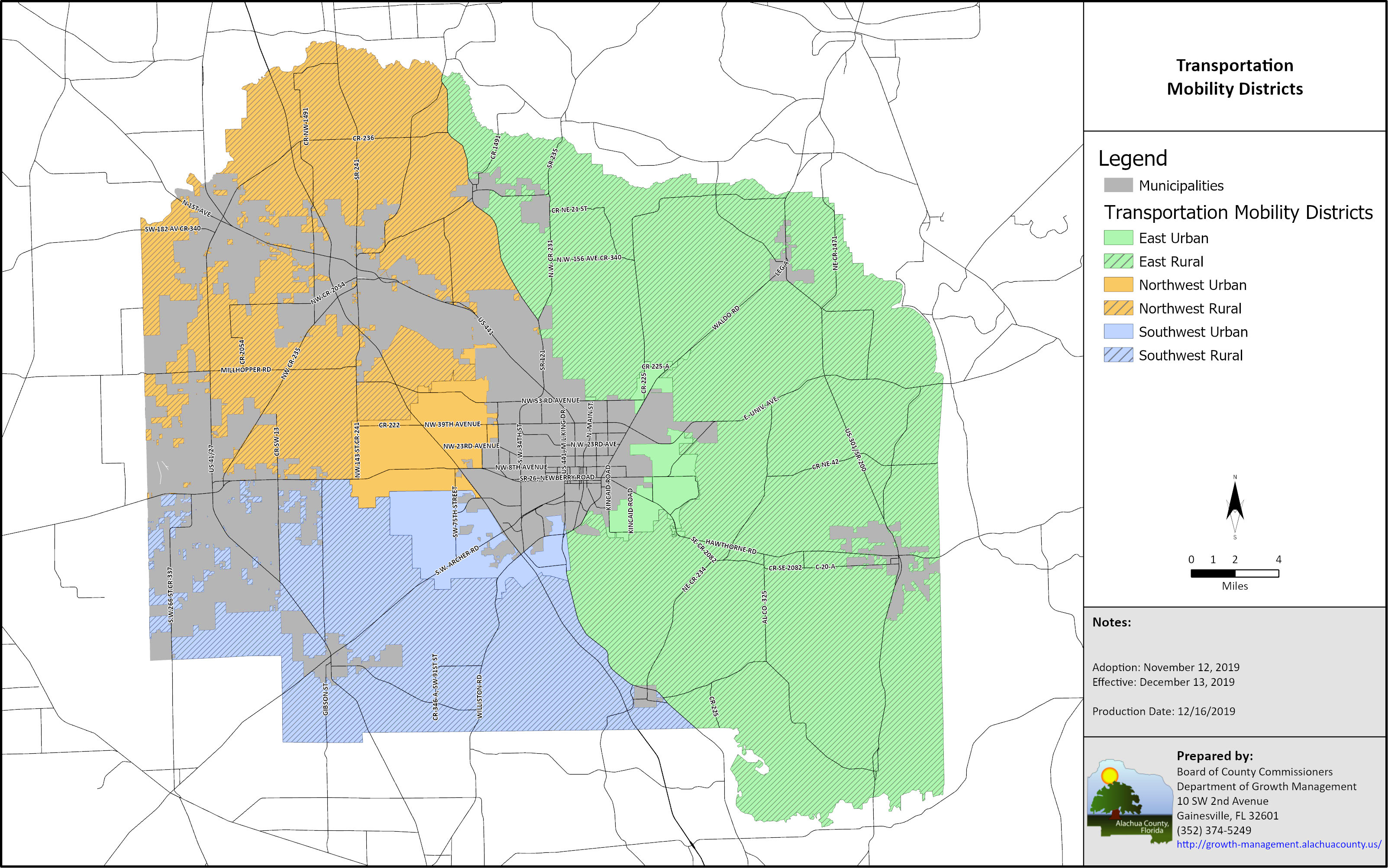
Map c. Express Transit Corridors
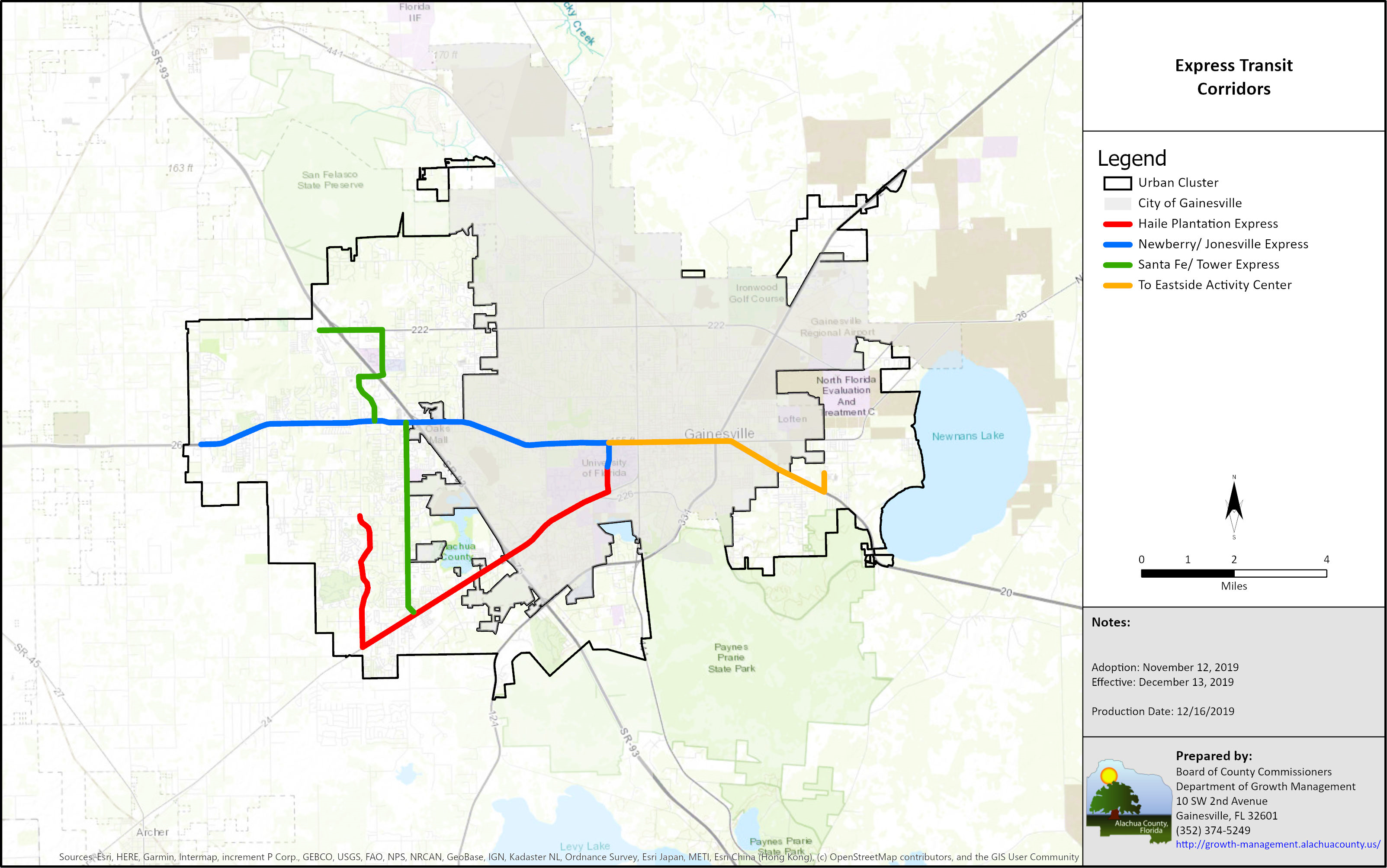
Map d. Rapid Transit Corridors

Map e. Wetlands and Floodplains
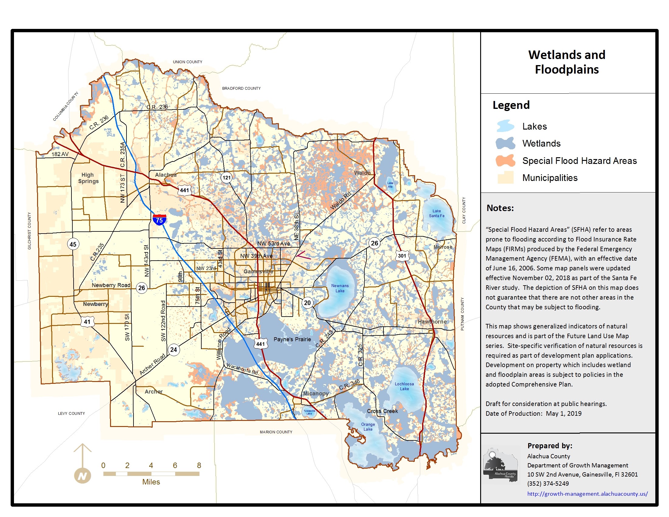
Map F1. Archer Road/SW 34th Street Activity Center/Retail and Special Area Study

Map F2. Idylwild/Serenola Special Area Study; Williston/I-75 and Williston/SW 13th St. Activity Centers

Map F2a. Idylwild Serenola Special Area Study, Environmental Resources

Map F3. Tower Road/24th Avenue Activity Center
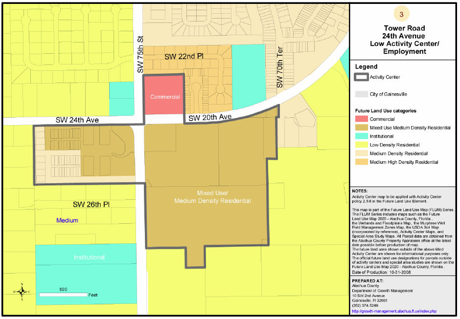
Map F4. Archer Road/Tower Road Activity Center
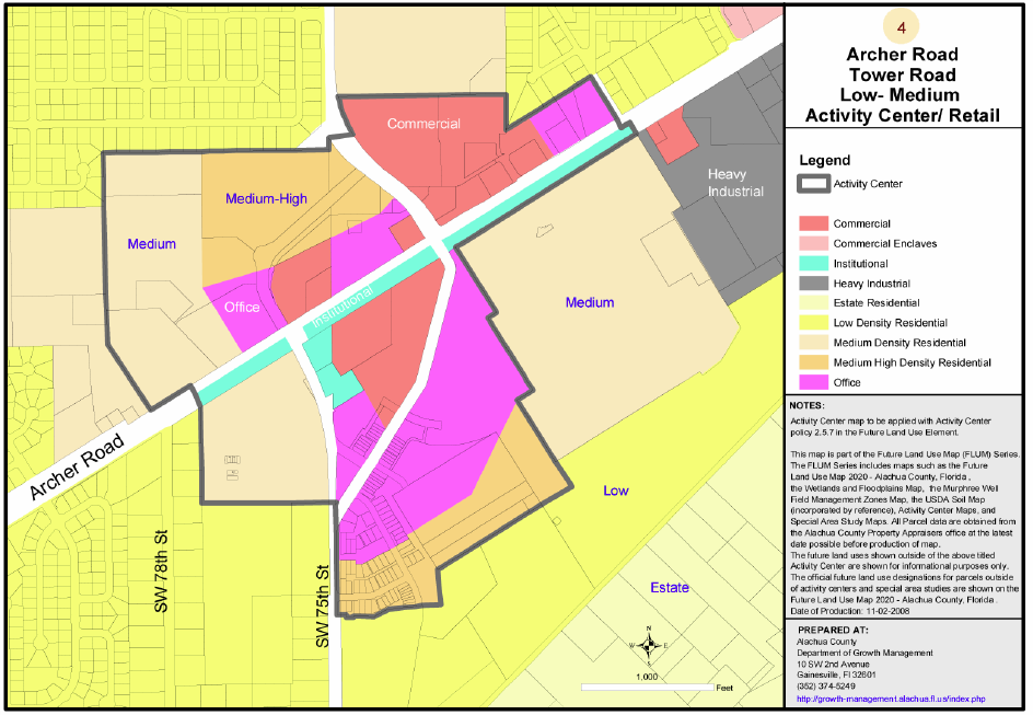
Map F5. Jonesville Activity Center
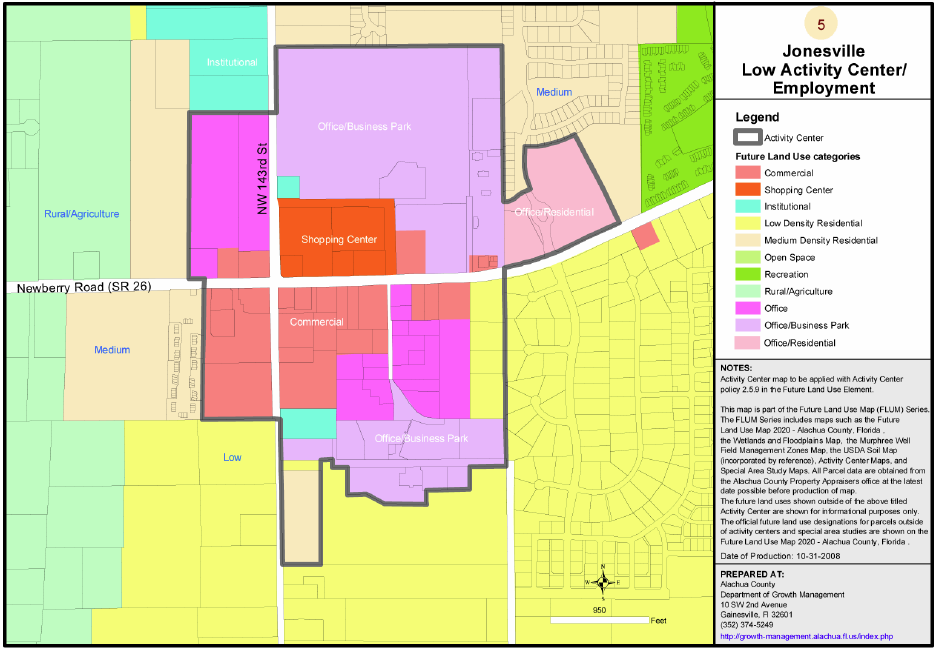
Map F6. Millhopper Activity Center
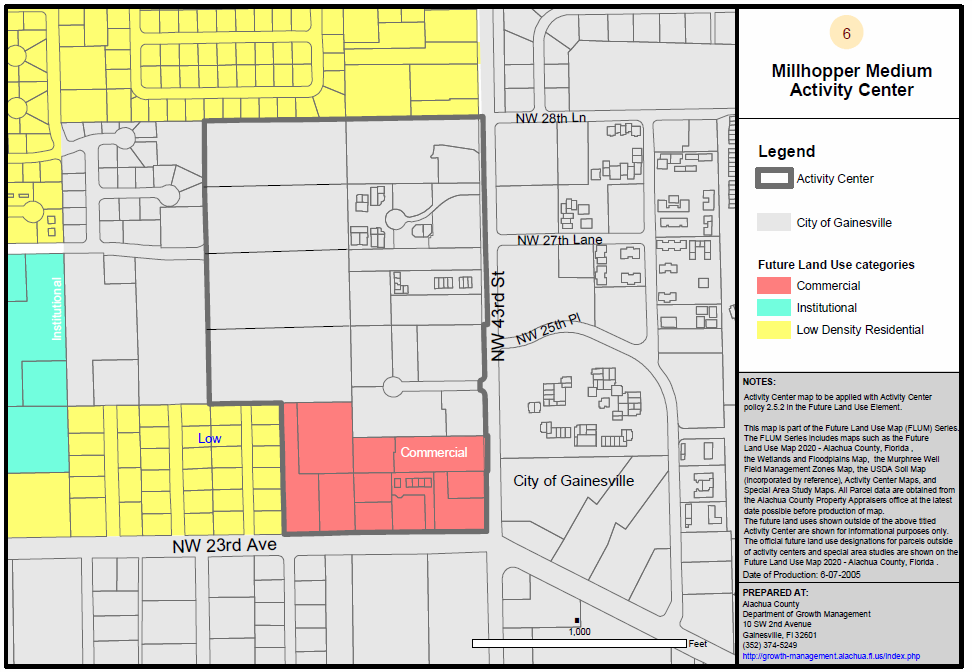
Map F7. North Main Street/NE 53rd Avenue Activity Center
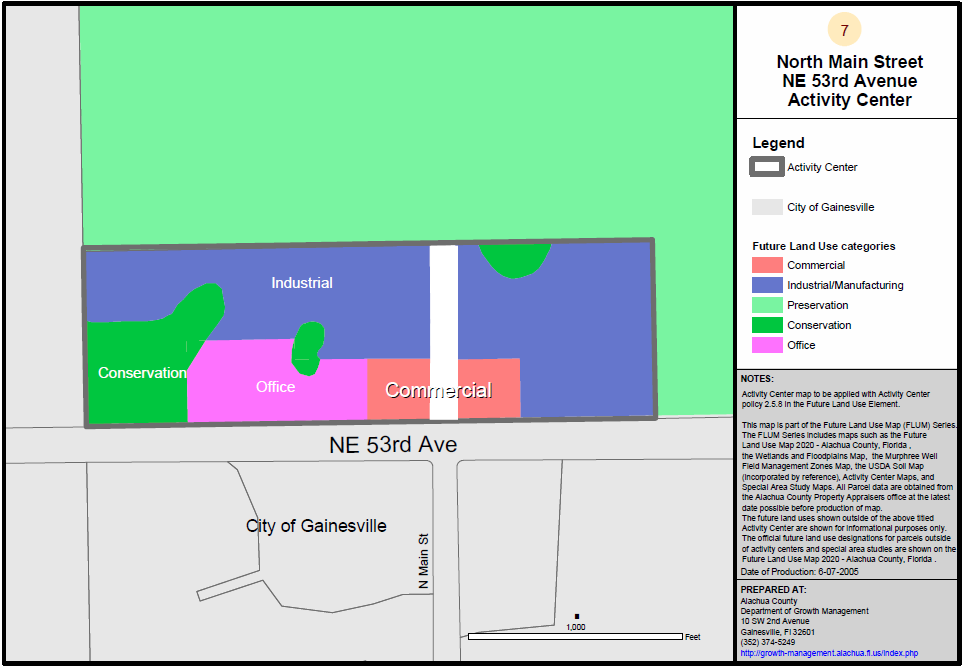
Map F8. Reserve
Map F9. Oaks Mall Activity Center
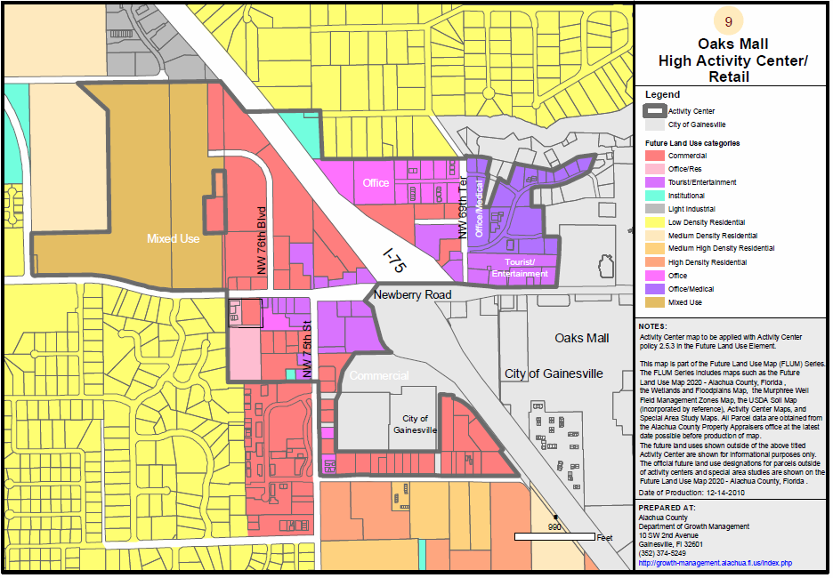
Map F10. Santa Fe Community College Activity Center
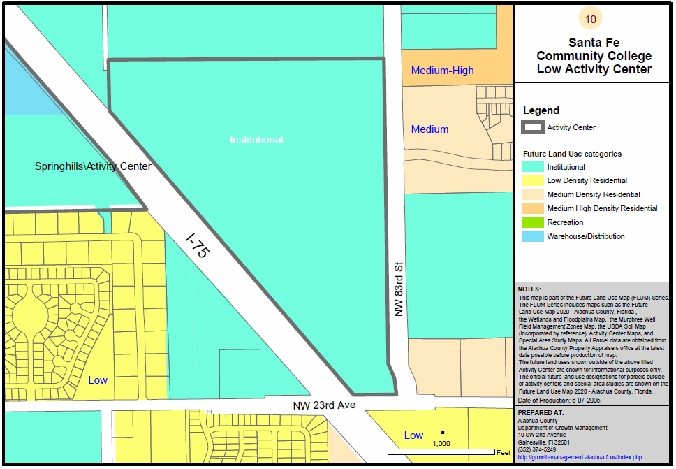
Map F11. Springhills Activity Center
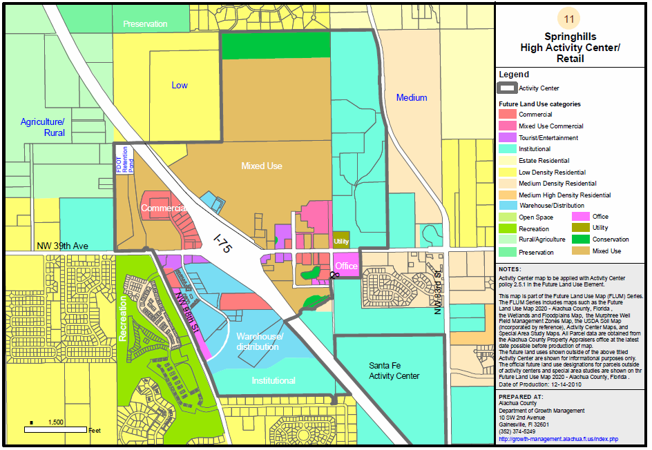
Map F12. East Side Activity Center
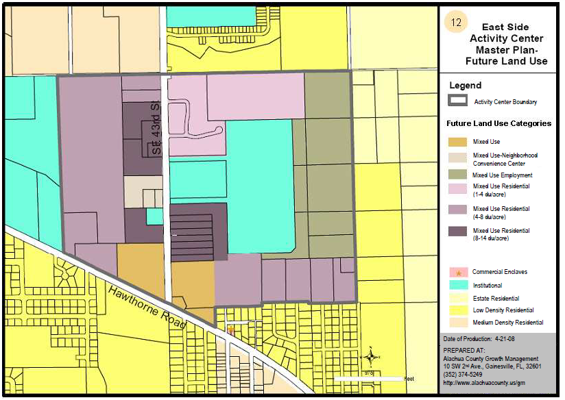
Map F12a. Eastside Activity Center Community Facilities
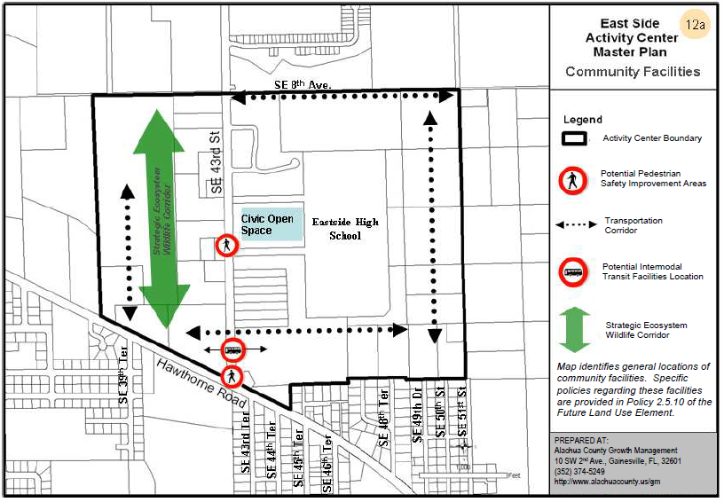
Map F13. Waldo Special Area Study Map 1
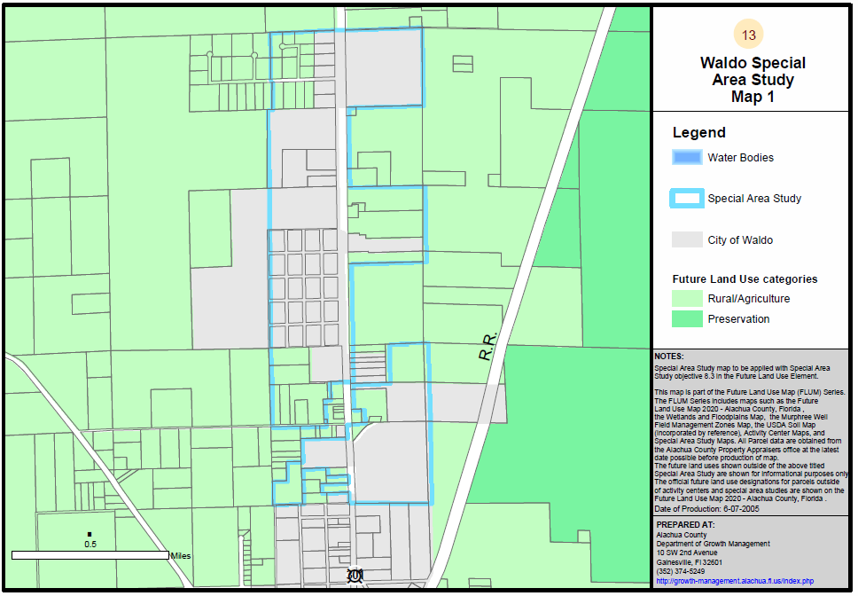
Map F13. Waldo Special Area Study Map 2
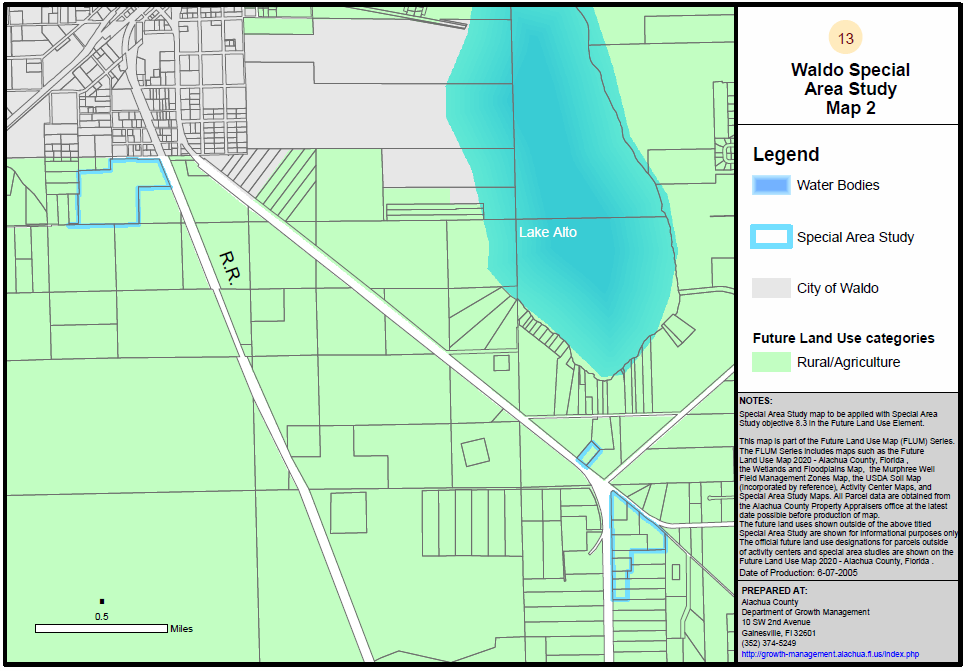
Map F14. North Main Street Special Area Study
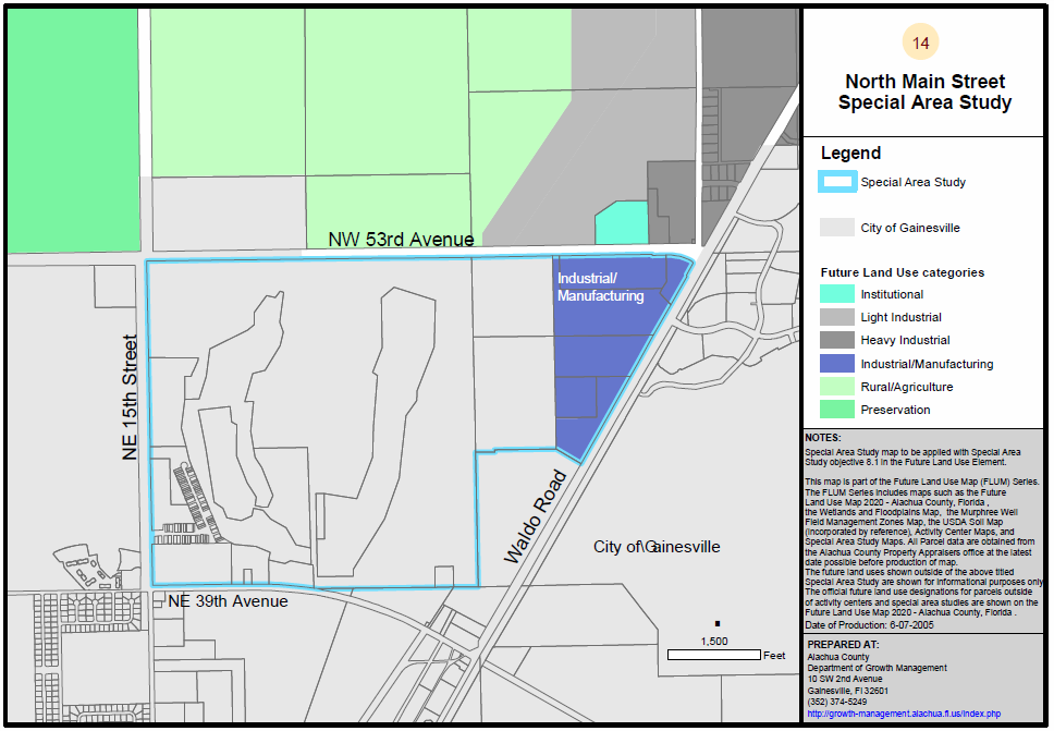
Map F15. Cross Creek Special Area Study
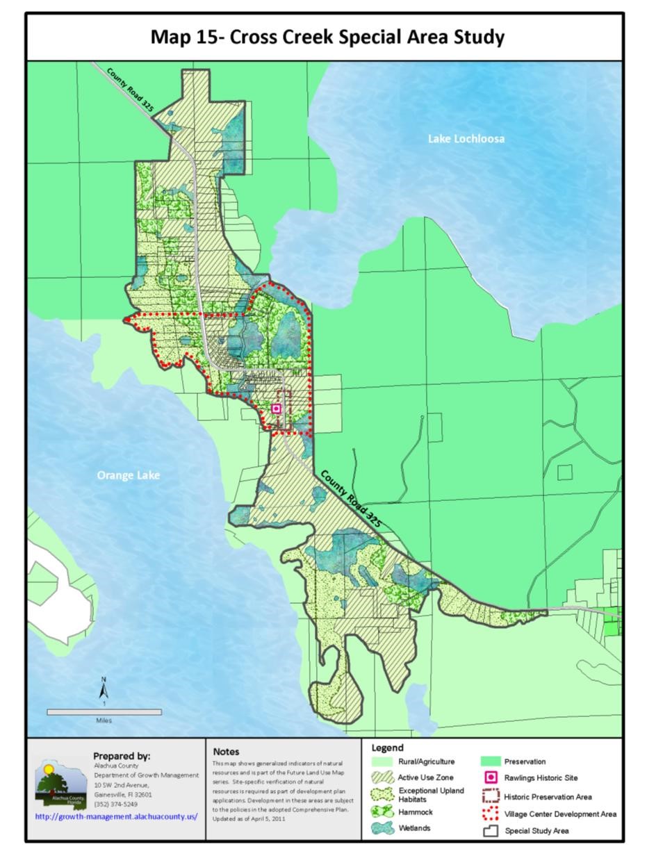
Map F16. Plan East Gainesville ‘Figure A’: Recommended Master Plan (Special Area Plan)
.png)
Top